Chris
Jensen, a member of our hiking group and an avid river advocate, had
suggested a hike to the headwaters of the Verde River. Chris, who
had been there before, agreed to lead us on the trip and it was
scheduled for 15 November 2014. We left Cottonwood under lightly
overcast skies, but with the hope that they would clear later in the
morning.
We
traveled to Paulden in two groups, one taking Hwy 89A to Prescott and
then traveling north on US 89 to Paulden while the other took the
dirt road that leads through the Perkinsville area. We planned to
meet at Depot 89, a convenience store just south of Paulden. The
group traveling on the dirt roads took considerably longer to make
the trip, but claimed the scenic views along the way well compensated
for the additional time.
Those
of us who arrived first spent the time people watching while we
waited for the scenic view group to arrive. A flea market was in
full operation in the spacious Depot 89 parking lot and a truly odd
assortment of individuals were hanging out there, some selling
products, just some browsing. The most noteworthy of these was an
elderly man with a white beard wearing a tan slicker and a large
western style hat, generally the sort of attire that might have been
purloined from the wardrobe of an old John Wayne movie set. On
closer inspection, however, the western look was utterly destroyed by
bare legs protruding from a grimy pair of shorts and ending in dirty
sneakers.
While
we were observing the goings on at the flea market, a large black
pickup roared into the parking lot and parked in the spot next to
where we were standing. Curious as to what sort of person might be
driving it we watched as a young boy, who just might have been old
enough for a learners permit, scooted down from the driver's seat and
strutted into the store. He returned barely five minutes later and,
seeing us still standing there, probably assumed that we had spent
the time enviously admiring his truck.
Apparently
pleased with the attention and thinking it would be ungracious to
just ignore such an audience, he paused to warn us about the dangers
of picking up hitchhikers. By way of illustration, launching into a
story about his father. It seemed that, one night on a dark and
lonely stretch of road, his father had, against his better judgment,
stopped to pick up a forlorn-looking hitchhiker. Then, just a few
minutes later, his car broke down and could not be restarted. Upon
seeing the hopelessness of the situation, the hitchhiker observed,
“This is your lucky day.”
“What
do you mean, lucky? I am stranded here in the middle of nowhere.”
“yes,
but you are still alive. Until your car broke down, I was planning
on shooting you and taking it,” responded the hitchhiker as he
walked off into the darkness.
The
kid then climbed back into the cab of his oversize pickup and roared
out of the lot in what would have been a cloud of dust had it not
recently rained.
After
the late arrivals from our hiking group had availed themselves of the
bathroom facilities and fortified themselves with snacks, we climbed
back into our vehicles, crossed the highway, turned south on old Hwy
89 and continued for about 0.1 mile. We then turned left onto Sweet
Valley Road, which runs through State Trust land, and drove for 1.1
miles before turning right on a dirt road that ended 1.2 miles ahead
on the east side of a wash that drains into the Verde River Canyon.
I
had originally thought the upper reaches of the Verde would flow down
Hells Canyon. I later learned that this section of the canyon
drained the Big Chino and Williamson Valley Washes and that the Verde
River originates in this area, between Sullivan Lake and Stillman
Lake. Hells Canyon, on the other hand, starts around 25 miles north,
as the crow flies, flows to the southwest for several miles, turns
south above Drake and then to the southeast to feed into the Verde
River Canyon about 17 river miles downstream from where we now stood.
We
donned our packs and posed for a group photograph before beginning
the hike.
 |
| Left to right: Miriam Sterling, Connie Woolard, Teal Sullivan, Chris Jensen, Gary Jacobson, Ruth Frazier, Betty Wolters, Lila Wright, Anita Jackson, Daisy Williams, Dave Beach, Bill Woolard, the author, Mark Purcell, Jim Manning and Bob Coates – photograph by Name Withheld |
We
needed to hike west to find a descent into the canyon and, as noted
above, we were parked on the east side of a wash. That, of course,
meant that we would have to find a way across the wash. That turned
out to be relatively easy, although it was a fairly steep climb down
into the wash and back up the other side. Once we were on the west
side of the wash we found a fairly well-defined trail to follow. The
trail soon enough led us close to the canyon rim and we had a good
view to the bottom of the canyon and across to the rim on the other
side as well as downstream.
Below
us we could see a faint trail tracing its way along the canyon floor
from where we would descend. This is the point where the Verde River
originates. We could see the upper reach of what Chris explained was
Stillman Lake, near the tree showing rich yellow fall colors near the
center of the below photograph. A large rock, which we later
learned carried some intricate Indian drawings along with some
latter-day graffiti, can be seen in the extreme lower right quadrant.
Stillman Lake is shown extending downstream at the left side of the
photograph, and Little Thumb Butte is visible on the horizon in the
upper left quadrant. Meanwhile, across the canyon on the opposite
rim, in the right upper quadrant, are several buildings, listed on
my, admittedly ancient, map as Morgan Ranch Headquarters.
 |
Our first view down into the Verde River Canyon at the headwaters
|
Chris
told us that the river once extended upstream to originate at
Sullivan Lake and an article posted on the National Wild and Scenic
Rivers System website still says that it “heads
at Sullivan Lake in the Big Chino Valley1.”
In contrast, agreeing with Chris, the Arizona Department of Water
Resources, on its website says, “The
Verde River originates in a steep-walled volcanic rock canyon near
Paulden below Sullivan Lake Dam (now almost entirely filled with
sediment). Springs feed the headwaters near the upper end of
Stillman Lake2”.
As
can be implied from these opinions about the origin (or head) of the
Verde, there are various definitions as to what constitutes the
source of a stream. For instance, the source of the Colorado can be
said to be at the Continental Divide.
 Not
overly interested in such exotica at the time, we just continued on
our way west along the rim of the canyon looking for a way to descend
to the floor below. For us the first water we could see was a good
enough definition for headwaters of the Verde. The descent turned
out to be 0.5 miles from where we had parked. It is well marked and
actually has a gate in an iron-rail fence. The photograph (right)
shows a hiker approaching the open gate.
Not
overly interested in such exotica at the time, we just continued on
our way west along the rim of the canyon looking for a way to descend
to the floor below. For us the first water we could see was a good
enough definition for headwaters of the Verde. The descent turned
out to be 0.5 miles from where we had parked. It is well marked and
actually has a gate in an iron-rail fence. The photograph (right)
shows a hiker approaching the open gate.
It
is actually possible to descend the canyon wall at this point by
several different routes, but if one just looks for it there is a
fairly well-defined track, following what is likely the easiest
course available.

Volcanism
along with subsequent erosion and earth movement have left some
interesting rock exposed. The photograph (left)
is but one of several seen on the way down.
When
we arrived at the canyon floor the hiking became much easier, but
before proceeding we stopped for our midmorning snack. We had after
all been on the road and hiking for the better part of two hours now.
Upon finishing our break, I again hiked behind the rest of the group
because we had found some Indian paintings on the large rock that had
been visible from the rim and I wanted to examine and photograph
them. The left half of the rock, as shown below, was covered with
intricate Indian drawings while the right half was devoted to
graffiti of a more recent era.
 |
Indian drawings on a large rock at the Verde River Canyon headwaters
|
 A
little farther on was a smaller rock (right)
also inscribed with drawings.
A
little farther on was a smaller rock (right)
also inscribed with drawings.
We
saw several other interesting drawings along the way and I
photographed a number of them as shown on the following page.
Four
examples of Indian drawings, thankfully without graffiti, are shown
below. Because I am not sure what any of these drawings represent, I
present them without comment.
 |
| Drawings at Verde River headwaters |
 |
| Drawings at Verde River headwaters |
 |
| Drawings at Verde River headwaters |
 |
| Drawings at Verde River headwaters |
Still
bring-ing up the rear, I noted a sudden disturbance among the main
group of hikers ahead and hurried to catch up. It turned out that,
while examining drawings, located too high to see well from below, a
hiker's foot had slipped into a crevice and he had fallen sideways.
It appeared that his ankle was broken. Carrying him out was out of
the question, both because of the difficulty of climbing the steep
cliff and because of the danger of further injury, so we called
Search and Rescue.
Although
we provided GPS coordinates, we decided that someone should return to
the road where we were parked to guide the rescue party to the site.
That way we could get them quickly to the injured hiker without their
losing time searching for a way down the cliff. Jim Manning
volunteered for the job and, along with another hiker, I accompanied
him. The third hiker, perhaps a little too anxious to make sure he
arrived at the road in time to meet the rescuers when they arrived,
sprinted up the final few yards to the top of the cliff and promptly
set out in the wrong direction on the trail that runs along the rim.
By the time Jim and I emerged at the top, he was nowhere in sight.
We now had a missing hiker as well as an injured one.
Unable
to determine where the missing member of our party had gone, Jim and
I proceeded toward the road where we expected to meet the rescue
party. We both continued far enough that we could see the trail all
the way to the road and thus make certain that our lost hiker had not
gone in that direction. I then waited there in case he realized his
mistake and returned; Jim continued on to the road to meet the rescue
squad, which had now arrived, and give them directions. I waited
where I was until a member of the squad reached me and accompanied
him to the descent point from where the hikers below were visible.
From there he continued on his own.
I
stayed on the rim near the descent, still hoping our missing man
discovered his error and returned that way. Except for the gash cut
by the canyon, the terrain was relatively flat and open, so surely he
would eventually find his way to a road. If nothing else, Highway 89
was only about a mile west along the canyon rim. Also, this was a
good vantage point from which I could see what was going on below.
When
the rescue squad member who had proceeded into the canyon had
completed his assessment of the injured party and the problems
associated with carrying him out, he called for a helicopter.
Although the terrain might not be favorable for a carry-out rescue,
there was a good spot for a helicopter landing on the open, flat
canyon floor.
When
the helicopter arrived, it landed alongside the trail, about 150
yards from the injured hiker.
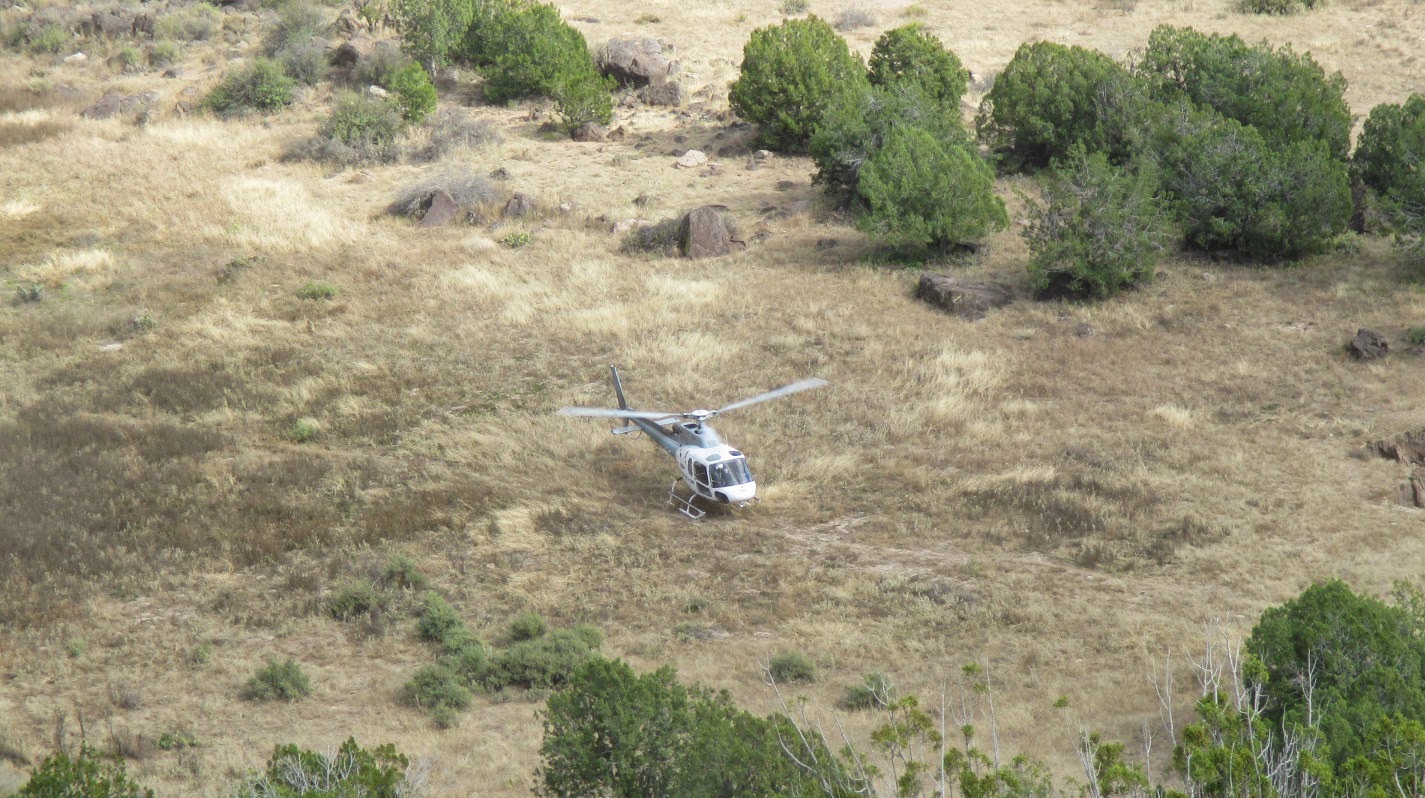 |
Rescue helicopter on the canyon floor as seen from the rim
|
Having
decided that, after all this time, it was very unlikely that our lost
hiker would return this way, I left as soon as the helicopter lifted
off and made my way to join Jim. Fortunately, by the time I arrived
so had the missing hiker and, soon after, the remaining hikers
returned from the canyon. Except for the injured hiker now on his
way to the hospital with what was determined to be a broken ankle, we
were finally all accounted present.
Although
Chris did lead some of the hikers about another mile down the river,
the round trip distance recorded by my GPS for this hike was 1.8
miles, the maximum elevation was 4512 feet and the total ascent was
254 feet.
The
GPS track for the hike is shown in Figure 1 on the included map (next
page)
in red. The blue track shows the route from Depot 89 to the
trailhead. Figure 2 on the map page shows close-up details of the
hike area.
 |
Figure 1 – Route from US 89
|
 |
Figure 2 – Hike area details
|
lands/PlanningAreaOverview/SurfaceWaterSaltVerdeWatersheds.htm
No comments:
Post a Comment