Directions
from Cottonwood are as follows: drive through Camp Verde on Hwy 260,
turn right on Fossil Creek Road (ten miles from the Hwy 260/I-17
interchange at Camp Verde) and continue for another 8.9 miles to
arrive at the Towel Creek Trail Trailhead. There is no designated
parking area; however, the road is wide enough to permit parking
alongside. These directions are for reaching the trailhead;
however on this hike, we actually stopped just past Needle Rock,
parked at a wide open area on the east side of the road about 200
yards short the actual trailhead. After parking, we climbed
over a fence, bypassing a locked gate, followed a road across the
Hackberry Springs Wash and then turned south, still following an old
road, to connect with the Towel Creek Trail. The way we went is
actually shown on the USGS overlay for Google Earth as being Towel
Creek Trail. I think the trail must have been rerouted sometime
in the past to avoid a Ranch house located just across the wash from
where we parked.
After
crossing the gated fence, we paused for a group photograph with
Needle Rock in the background before continuing our hike.
 |
Left to right: Fran Lind (kneeling), Miriam Sterling, Becky Fowski, George
Everman (kneeling, front), Bob Wakefield (kneeling, behind George),
Jim Manning, Annie Johnson (kneeling), Lila Wright, Dave Beach,
Akemi Tomioka (kneeling), Janet Wakefield, Dolly Yapp (kneeling),
Name Withheld, Daisy Williams (kneeling), Anita Jackson,
Mary Gavan and the author (kneeling)
|
As
we traveled south along Hackberry Springs
Wash toward the connection with Towel Creek Trail we encountered a
herd of horses (second
photograph
below).
They were very friendly but lost interest once it was determined that
we were not dispensing snacks. Connecting with the trail, we
continued along the southeast slope of Hackberry Mountain. At
first we were actually on the slope of a thousand foot lower
formation that separated us from Hackberry Mountain proper and
shielded it from view. It was not until we passed Pombo Tank,
over half way to Towel Tank, that we could actually see Hackberry
Mountain. We were still traveling southeast and now had
Hackberry Mountain in view on our now right and could see the Towel
Peaks directly ahead. When we reached Towel Tank, located
between Hackberry Mountain and the Towel Peaks, we would turn west
and go directly between those two formations, following Towel Creek
Trail on toward our goal, the Indian Ruins located near the Verde
River.
On
arriving at Towel
Tank, we were confronted by a herd of cattle. Like the horses
we had encountered earlier, they lost interest as soon as it was
determined that we didn’t come bearing edible goodies.
Pictures
of both the cows and the horses are shown below.
 |
Herd of cattle at Towel Tank.
|
The tank is
located at the top of the saddle that separated Hackberry Mountain to
the north from the Towel Peaks to the south.
 |
Herd of horses encountered between the ranch house below Needle
rock and Towel Trail
|
Towel
Tank lies in the saddle that separates Hackberry Mountain to
the north from the Towel Peaks to the south. To this point we
had climbed gently along a rocky trail from Fossil Creek Road.
From here we would follow an equally rocky trail sloping a little
more steeply down to the Indian Ruins. The picture shown on the
next page accurately illustrates the type and condition of the trail
for most of its length. The picture was taken as I descended
into a wash and shows the ascent on the other side.
Only six
hikers intended to hike all the way to the ruins. Some of the
others had already visited them on a recent scouting hike and some
simply wanted a shorter hike, so we separated not far beyond the
tanks, with George, Akemi, Jim, Mary, Ellis and Becky continuing on.
 |
The rocky Towel Creek Trail required close attention to footing.
|
About
two-thirds of the way from Towel Tank to the ruins we came upon a
short section
of the creek that actually had a small trickle of flowing water.
There were no cattle in the area at the time; however, we saw plenty
of fresh signs indicating it is heavily used. Having just
stopped for a rest and a snack break shortly before arriving at the
flowing water, we did not pause, but pressed on toward our goal.
Form
here the trail was a little less discernible, although we found
occasional cairns placed along the way. Fortunately, all the
false trails made by cattle soon come to an end and it is then
apparent that one has made a wrong turn.
On
reaching the area of the ruins it is necessary to cross the wash and
bushwhack up the hillside on the other side to access them. At
the point where we left Towel Creek Trail (2.1 miles short of the
river) we could see both ruins set in the cliffs across the creek.
Easing our descent to the creek was a side trail that angled upstream
and descended to the bottom. The way up to the ruins was fairly
steep but open and we were soon settled in at the larger
(westernmost) of them eating lunch.
 |
The larger of the two ruins in the area
|
After
lunch and my traditional nap we
traveled the short distance eastward along the cliff face to look at
the smaller ruin.
 |
This is the smaller of the two ruins
|
I
did nothing more than stick my head
inside either of the ruins; they are both being used extensively by
bats and the floors are deeply carpeted with enough nitrogen rich
guano to keep the most avid gardener happy for several seasons.
We
descended back to Towel Creek upstream
from where we had ascended to the ruins and followed a wash up the
slope to access the trail. We should have returned the way we
came; it would have been easier. We made, primarily at my
insistence, several stops during the rock stream climb back to Towel
Tank. I really didn’t realize how dehydrated I had become
until I weighed myself before stepping into the shower that night and
found that I was several pounds lighter than normal.
For
some reason
George had poker chips with him (Was he trying to get a game
started?).
One of
the other hikers who turned back early got his hands on one and left
it squarely in the middle of a cow pile (right)
for George to find on the way back.

After
the hike I learned
from Lila that the group that turned back early visited the Tee Pee
Rocks on the way home. This formation, a clustering of
fumaroles related to an eruption of Hackberry Volcano about 7 million
years ago, is located just off Fossil Creek Road about a mile from
Hwy 260.
The
following is quoted from
an article by Steve
Ayers in the Camp
Verde Journal:
The
unusual formations
are called fumaroles. They are the result of hot volcanic ash falling
on a surface that is saturated with calcium rich water, such as the
shores of the former "Lake Verde." The water in the ground
turns to steam and vents upward through the fallen ash.
Where the calcified water comes
in contact with the ash a layer of cement-like material is formed.
Over time, the softer ash around the vents is eroded, leaving the
conical shaped vent pipes exposed.
The
pockmarked holes are the result of water eroding the base
of the cones as they slowly expose themselves to the elements.
The Cottonwood
Basin Fumaroles resulted from an eruption of Hackberry Volcano that
took place about 7 Ma {million
years},
give or take a Ma.1
For
a look at active fumaroles one has no farther to go than Salton
Sea in Imperial County, California. A shallow magma body
underlying the area causes the activity there; carbon dioxide is
released and conveys subsurface mud to the surface. These
fumaroles are located in a mud field and, although you can drive to
the edge of the field, it is difficult to get really close to the
fumaroles without sinking into the muddy surroundings.
Here
is a shot by David Beach of the fumaroles at Tee Pee Rocks
 |
Fumaroles at Tee Pee Rocks
|
Bob
Wakefield
got a couple of good flower photographs
along the way. He identifies them as a Desert onion and
“possibly” as Indian Mallow or Abutilon palmeri.
 |
Desert onion
|
 |
Abutilon palmeri
|
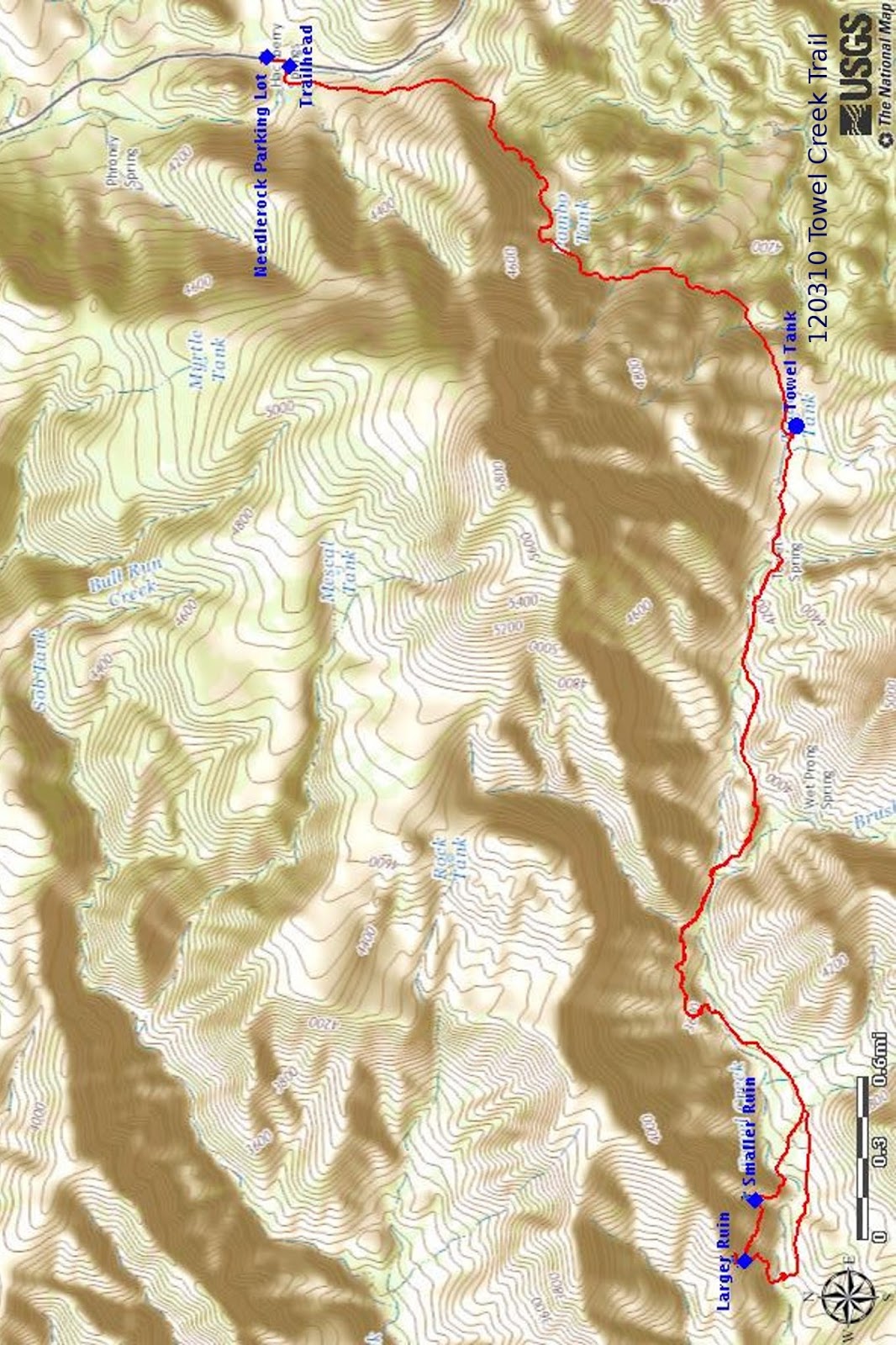
The GPS Track
for this hike is shown in red on the included map (below).
Note that the track shown is the actual present-day trail; it avoids
climbing the fence at the locked gate. From the Needlerock parking
lot, one walks a short distance south along Fossil Creek Road to join
the trail at the official trailhead.
The round
trip distance from the parking lot for this hike is 10.2 miles, the
highest elevation is 4465 miles and the total ascent is 1959 feet.
1
https://www.cvbugle.com/news/2010/mar/23/a-violent-past-a-brief-history-of-verde-valley-vo/
No comments:
Post a Comment