Nine
hikers from the Skyliners group hiked on Telephone Trail #72 in Oak
Creek Canyon on Saturday, 06 November 2010
We
drove through Sedona on Hwy 89A and parked alongside the road about a
tenth of a mile beyond mile marker 385. From there we hiked a bit
less than a tenth of a mile further to reach the trailhead. Contrary
to what we had been led to believe, parking was not a problem; even
though it was almost 9 AM on a Saturday morning. It should be noted,
however, that when we completed the hike around 3 PM, the area
parking was at a premium.
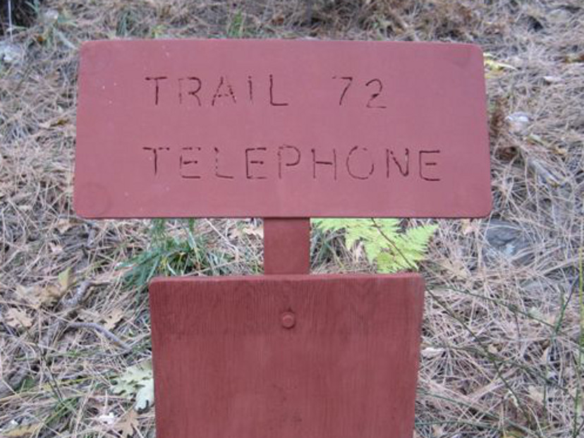 The
trailhead is fairly well marked (right - photograph by George), although one must know where to look
and be alert to avoid missing it.
The
trailhead is fairly well marked (right - photograph by George), although one must know where to look
and be alert to avoid missing it.
The
trail runs up the canyon, parallel to the highway for just over a
tenth of a mile before turning sharply up the canyon wall. This area
of the forest has recently been thinned, and the workers apparently
appropriated a section of the trail for use during this operation.
Unfortunately, where the work trail leaves Telephone Trail, it is now
much more obvious than the original trail, and we made the mistake of
continuing on the work trail at this point.
 After a while, finding
that we were circling back down the slope, we turned back to
intersect Telephone Trail near the point where we had left it. This
side trip is included in the round trip hiking distance given in this
report and is shown separately, in green, on the attached Google
Earth map.
After a while, finding
that we were circling back down the slope, we turned back to
intersect Telephone Trail near the point where we had left it. This
side trip is included in the round trip hiking distance given in this
report and is shown separately, in green, on the attached Google
Earth map.
Just
over half a mile from the trailhead (not counting our side trip on
the work trail), we came out on top of a sharp ridge with a view down
the other side into another side canyon. We stopped here for a snack
before continuing southeast along the trail, which ran just below the
crest for a distance, then crossed over and followed the other side
of the crest to a sharp narrow ridge of rock that formed the spine of
the ridge crest at that point. This section of rock (left)
has several windows (or peepholes, as some call them) through which
one can look through back down into Oak Creek Canyon. Several
pictures of these windows are shown below.
 |
Window in rock crest of ridge
|
 |
Window in rock crest of ridge – tree beyond
|
 |
The trail leads between the tree and the windows
|
 View of Oak Creek Canyon through the window – by George Everman |
 |
Kissing rocks at top
|
The
section of trail between where we had stopped for a snack and the
window rocks was fairly easy, following at generally the same level
along the ridge spine. Soon after passing the window rocks, however,
the trail, still following along the ridge between side canyons, grew
sharply steeper and was a bit difficult to follow in places.
Fortunately, wrong turns soon became apparent and we never had to
retrace our steps more than a few yards. A rock formation known as
the “Baby Carriage”came into view as we continued our climb. To
me it looked more like Albert the Alligator, from the old Pogo
comic strip, with Pogo the Possum astride his neck, than a baby
carriage.
 |
The Baby Carriage
although I still see a Possum (Pogo) riding an Alligator (Albert)
|
Not
more than two tenths of a mile of steep climbing from window from the
rocks we came to what we decided must be the end of Telephone Trail
on top of the canyon rim. Although there were signs of old roads in
the area, we found no discernible trail beyond this point, and
stopped here for lunch. We were approximately one mile from the
trailhead on Hwy 89A.
After
lunch for everyone and a quick nap for me, we walked on along the rim
in a generally southwest direction for about two tenths of a mile.
We had some discussion about continuing along the rim and descending
by way of the Thomas Point Trail. However, we were uncertain how
difficult it would be to find the start of that trail and decided to
return the way we came, putting off a Thomas Point-Telephone Trails
Loop for another day.
Climbing
the trail had been difficult due to the steep gradient; traveling
back down, while much faster and easier, presented difficulties of
its own. I heard several hikers say that it was much harder on the
knees than the climb up had been. But we all made it in good
condition and paused at the lower trailhead for a group photograph.
We
also had a great view of Mount Agassiz framed by trees as we
approached the top of the trail.
 |
Magnified view of Mt. Agassiz framed by trees
|
 |
Left to right: Daisy Williams, John McInerney, Linda Tovar, Betty Wolters,
George Everman, Miriam Sterling, Name Withheld, Donna Goodman
– Photograph by the author
|
The
total hiking distance was just about four miles. That includes a
short hike from where we parked to the trailhead, the work trail hike
that we inadvertently took, and the extra four tenths of a mile we
hiked along the rim after lunch. The elevation change, according to
my GPS file was about 1370 feet.
The
GPS track for this hike is shown on the included map (below).
Telephone Trail is shown in red; the yellow track shows where
wandered along the rim.

No comments:
Post a Comment