The
original plan for this hike was to start at the Bell Rock Parking
Area, hike about 0.2 miles on Bell Rock Path, take Big Park Loop to
Courthouse Butte Loop and and then turn off of Courthouse Butte Loop
at a wash and follow an ancient but unofficial trail that leads east
along the south side of Munds Mountain to the Rabbit Ears formation.
We would then take another unofficial trail along the backbone of a
ridge to arrive back at the junction of Big Park Loop and Courthouse
Butte Trails. From there, we intended to retrace our path back to
the Bell Rock Parking Area.
Unfortunately,
while I was busy drinking a hot tea that I had carried with me and
fumbling with my GPS, we failed to turn right at the Big Park Loop
Trail junction. When I finally noted that we had deviated
significantly from the track we intended to follow, we decided that
rather than turn back, we would just continue the way we were headed
until we hit Courthouse Butte Loop Trail and then follow it to our
turnoff to the Rabbit Ears Trail. That turned our intended
tadpole-shaped hike into a double loop hike, actually a rough figure
eight.
Shown
below is the trailhead as the trail leaves the kiosk at the Bell
Rock Vista Parking lot.
 |
| Trailhead at the kiosk located at Bell Rock Parking Area |
The
trail we were now on, actually still a part of the Big Park Loop but
leading us in a clockwise direction as regards the Big Park Loop
instead of our intended counterclockwise direction. Bell Rock could
be seen to our left and Courthouse Butte was straight ahead.
We
stopped at a convenient spot along the way for a group photograph.
 |
| Left to right: Bob Rauen, Ellen McGinnis, Daisy Williams, James McGinnis, Floyd Gardner, Anita Jackson, Joanne Hennings (kneeling), Connie Woolard, the author (kneeling) Jim Manning, Loren Pritzel, Lila Wright, Bill Woolard and Karl Sink – photograph bu Name Withheld using the author's camera |
About
0.6 miles from the trailhead we came to the western intersection of
Big Park Loop Trail and Courthouse Butte Loop Trail. From this point
we followed Courthouse Butte Loop Trail almost directly east for
around 0.6 miles to the eastern junction of Big Park Loop Trail with
Courthouse Butte Loop Trail. In effect, that 0.6-mile section might
more accurately be labeled both Big Park Loop and and Courthouse
Butte Loop. As a matter of fact, the Forest Service itself is
somewhat inconsistent in naming this particular section of trail.
Although the signs posted on the trail itself refer to it as
Courthouse Butte Loop Trail, an area trail map posted at another
point along the trail refers to it as being part of Big Park Loop
Trail.
Looking
to our left as we hiked along this section of trail, we had
awe-inspiring views of the sheer rock walls of Courthouse Butte.
 |
| Courthouse Butte as seen from Courthouse Butte Loop Trail |
At
the point where the eastern leg of Big Park Loop Trail intersects
with it, Courthouse Butte Loop Trail turns north to follow a wash
alongside the eastern edge of the butte. The following photograph
shows Anita Jackson standing on the trail. Although one can easily
hike up the solid rock bed of the wash itself, the actual trail
climbs past the sign shown at right, turns left where Anita is
standing, and then follows along the bank about five feet above
bottom.
 |
| Anita Jackson standing on Courthouse Butte Loop Trail |
Just
under 0.1 miles up the trail from here, at a point marked by the tree
shown (below left), the wash turned
right and crossed the trail. We followed the wash at first but then,
almost immediately, left the wash by the left bank at the spot
pointed to by the hiker (below right).

Choosing to turn right
in the wash and continuing for a few yards had put us firmly on
Rabbit Ears Trail. Actually, the digital map (Arizona Topo Map)
that I use in my GPS, available as shareware from GPSFileDepot1,
shows two trails (Rabbit Ears 1 and Rabbit Ears Alt) for part of the
way to the formation. We followed the one termed Rabbit Ears Alt
because it was the most-used and easier route. After leaving the
wash, the trail climbed for a distance through a juniper forest
before coming out at a large flat rock ledge. This afforded us our
first good view of the Rabbit Ears formation, standing apart from the
hulking cliffs that mark Munds Mountain.
 |
| Rabbit Ears visible in the upper right quadrant; flat rock ledge in foreground |
We
continued hiking across flat rock ledges interspersed with stands of
juniper before entering a more heavily forested area with deep
washes. We crossed one deep wash and then hiked up another,
following the well-used and easily discerned trail all the way. On
previous hikes in the area, it had often been necessary to choose
carefully between different trails used by the mountain bikers who
frequent the area. Now the bikers seem to have pretty much settled
on the best routes, making following the trail considerably easier.
We did, of course, find the occasional detour to a good viewpoint but
these were easy to distinguish from the more well-traveled main
trail.
About
1.4 miles from Courthouse Butte Loop Trail we were at the closest
point on the trail to the Rabbit Ears formation. We were at a sunny
spot where the trail the trail crossed a bare, rocky spot and the
sun-warmed rocks provided ample room to sit or recline while we
admired Rabbit Ears, about 0.3 miles away, in comfort. Shown below
is a magnified view of the formation from a December 2010 hike with
George Everman, Lila Wright and Jim Manning.
 |
| Rabbit Ears in 2010 photograph taken from o.3 miles away |
When
we were finished basking in the sun at the Rabbit Ears Viewpoint, we
continued on along the trail for another 0.2 miles, winding our way
around an outcropping and through a saddle in the boomerang-shaped
ridge that lies between Munds Mountain, and Jacks Canyon to end at a
trail named, according to my GPS, Dairy Springs. From this trail
junction, one leg of Dairy Springs runs south along one wing of the
boomerang to connect with Jack's Canyon Trail. The other track,
which we took, leads west along the other boomerang wing to end at
the east junction of Courthouse Butte Loop and Big Park Loop Trails,
thus completing one section of the double loop which this hike forms.
As
we made our way along the sometimes rocky but well-defined trail,
passing through a mixture of juniper and manzanita, we had great
views of some of the most well-known area landmarks.
 |
| Courthouse Butte is seen in the center; Castle Rock (standing alone) is shown to the left of Courthouse Butte and a bit of Bell Rock is visible between the two; Cathedral Rock is visible in the distance to the right of Courthouse Butte |
As
we neared the trail junction we stopped for lunch on a high ridge
overlooking Courthouse Butte Loop Trail as it made its way along the
east side of the butte. Although we had not encountered many other
hikers on the 0.7 miles of Courthouse Butte Loop Trail we had hiked
earlier that morning, it was now obvious that traffic had increased
tremendously. We counted one group of at least 20 hikers along with
several smaller groups and a few individual hikers while we were
perched on the ridge.
By
1210 we were ready to close the second loop of our two-loop hike by
hiking south leg of Big Park Loop Trail back to the parking lot. The
distance back by the south leg was only 1.3 miles, very close to the
distance it would have been to retrace our path of earlier that
morning. Since it avoided the busy Courthouse Butte Loop Trail
altogether, it was also likely to be less crowded. As it were, we
were back at our cars by 1255.
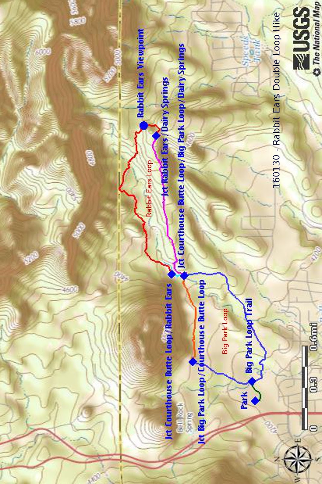
As
shown on the below map, I have divided the trail into several
different sections which will, hopefully, make things a little
easier. The lower part of Big Park Loop Trail is shown in blue, the
section of Courthouse Butte Trail that completes Big Park Loop Trail
is shown in copper, the 130-yard section of Courthouse Butte Trail
that leads to Rabbit Ears Trail is colored cyan, Rabbit Ears Trail is
red, the section of Dairy Springs Trail that completes Rabbit Ears
Loop is shown in magenta and the short connector between the parking
area and Big Park Loop Trail is colored green. As can be seen, our
double loop hike actually consisted of a Big Park Loop and a Rabbit
Ears Loop tied together.
Rabbit
Ears and Dairy Springs Trails are not official National Forest
trails.
We
hiked a total of 5.4 miles. The maximum elevation was 4712 feet and
the total ascent was 975 feet.
1Available
at: http://www.gpsfiledepot.com/maps/view/1/
No comments:
Post a Comment