This
hike was first proposed as a hike on Jail Trail. However, after
investigating the idea, we determined that the Jail Trail, running
from the old jail building on Main Street in Cottonwood to the Bridge
to Dead Horse, was only 0.5 miles in length. We obviously would need
to add something else to the hike, so Lila proposed that we start at
Riverfront Park and hike far enough up the river to make to make it a
good hike. We scouted the trail on 7 January, hiking all the way to
Tuzigoot Road and back, but not bothering to hike the short section,
about 0.1 mile, of Jail Trail that runs from Main Street down to
connect with the Riverfront Trail. In January, the trail was partly
covered by snow and a little muddy in spots. The only difficult
section was about the last 0.1 miles below Tuzigoot Bridge where the
trail just disappeared and we had to pick our was through thick
growth.
 On
7 March 2015, a beautiful, sunny but slightly chilly morning,
eighteen Skyliners gathered for a regular hike that would essentially
repeat January's scouting hike. We parked at Riverfront Park and
walked along the sidewalk past a service building, a sand-covered
play area and a swing set to connect with the main trail that runs up
and down the river. We were skirting the Frisbee (Disk) Golf course
and signs were posted along the trail warning of flying objects.
There are side trails all along the way. However, the main trail is
easily discerned all the way to Dead Horse Bridge. At the bridge, a
side trail runs down from the road and connects, through a stile,
with the main trail which turns sharply to the right toward the river
and then passes under the bridge along the river bank. A sign
(right) announcing the start of
Jail Trail is posted Just before the trail turns back north to cross
under the bridge.
On
7 March 2015, a beautiful, sunny but slightly chilly morning,
eighteen Skyliners gathered for a regular hike that would essentially
repeat January's scouting hike. We parked at Riverfront Park and
walked along the sidewalk past a service building, a sand-covered
play area and a swing set to connect with the main trail that runs up
and down the river. We were skirting the Frisbee (Disk) Golf course
and signs were posted along the trail warning of flying objects.
There are side trails all along the way. However, the main trail is
easily discerned all the way to Dead Horse Bridge. At the bridge, a
side trail runs down from the road and connects, through a stile,
with the main trail which turns sharply to the right toward the river
and then passes under the bridge along the river bank. A sign
(right) announcing the start of
Jail Trail is posted Just before the trail turns back north to cross
under the bridge.
As
we passed under the bridge, George and I were lagging behind while I
adjusted my GPS and, by the time we looked ahead again, the rest of
the group were lost to sight. This was not really a problem because
for, although there are a number of trails winding their way along
the river, we just had to continue north and we would be sure to
rejoin the group sooner or later. As it turned out, the main group
had taken a trail that forked right when they passed under the bridge
while George and I took the left fork. These forks can be seen in
the photograph below which was taken on the return hike.

As
it turned out the fork to the right led into a low-lying area which,
although it was approximately the way we hiked in January, was now
very muddy due to recent heavy rains. Two of the hikers, deciding
that they were not properly attired for hiking in the mud chose to
turn back here. Meanwhile George and I were hiking along a nice dry
trail. I could tell by referring to my GPS that we were not on the
track I had hiked before, but we were traveling parallel to it and
would eventually intersect with the Jail Trail which we could follow
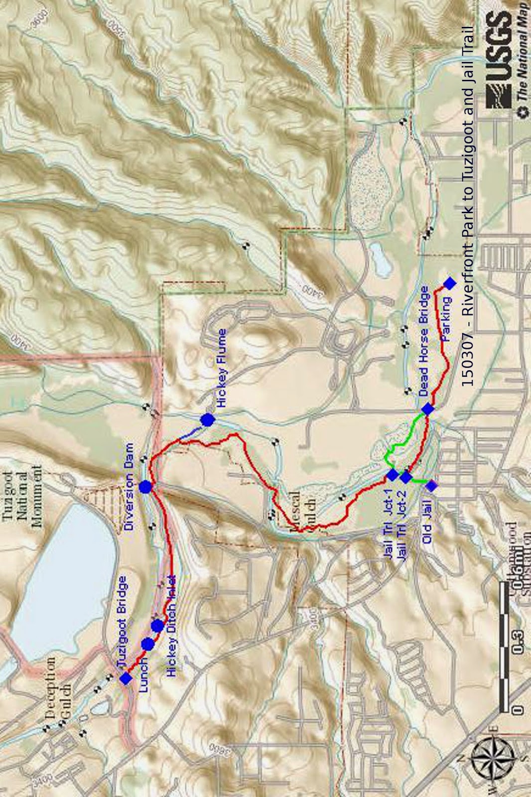
back to the main trail. In the below map insert, Jail Trail is shown
in green and the dry path followed by George and I, along with parts
of the main trail hiked in January, is shown in red. The section of
green track from Dead Horse Bridge to Jail Trail Jct-1 is also part
of the path we followed through this area on the January scouting
hike. The muddy path (not shown) followed by the main group of
hikers today was near the green line but reconnected with the main
trail farther upstream than the Jail Trail junction.
 |
| Insert showing Jail Trail and the way we hiked |
The
path that George and I took is probably the best way to hike this
trail, certainly following any heavy rainfall. However, on a hot
summer day it would be more exposed to the sun. As can be seen on
the map insert, we connected with Jail Trail about 100 yards south of
Jain Trail Jct-1. We then followed the trail back to the main track
and continued along the same path we had hiked in January.
Communicating
with the hike leader, Lila Wright, by cellphone, we found that we
were ahead of the main group and set a point farther up the trail,
where it passed very close to several houses, at which we would wait
for them. As we approached the area of the houses we noted a line of
rock and cement structures, about three feet tall, placed four to
five feet apart and strung together by a wire cable of about 1.5
inches diameter. Lila tells me that these structures were part of a
Civilian Conservation Corps (CCC) project. This would place its
construction in the 1930s. We could see no evidence that the spaces
between the separate rock and cement structures had ever been filled
with earth. On the other hand, any remaining signs could well have
been washed away during the last 80 years or so.
The
houses near which the two groups were to meet were nestled at the
edge of the flood plain close against a steep hill. We wondered why
in the world anyone would build in such a flood-prone spot. A couple
of the structures were protected by a concrete wall, but others were
not.
When
we passed this way last January a very boisterous rooster crowed at
us, starting as soon as we arrived at the edge of the small meadow
and continuing until we were well past it. This time we heard
nothing from him and wondered whether a hungry coyote might have
feasted on him. Or, perhaps the owner ate him.
The
main party soon arrived and we all continued upstream together,
passing through only one more really muddy area, the wash that drains
Mescal Gulch if I am correct. Otherwise the trail was relatively dry
and very easy walking, even widening into a little-used but still
quite passable dirt road as we crossed Horseshoe Bend heading to the
diversion dam that is pinched in between the cliffs at the foot of
Tuzigoot. Approaching the dam,we came first to the sluice gate that
provided water to Cottonwood Ditch. When we were there in January,
the only way across the ditch was to hold onto the valve wheel for
support and walk across on a plank atop the gate.
Now,
two months later, we found that dirt had been dumped into the ditch
filling an area wide enough to drive equipment across. Since the
dirt completely filled the ditch, blocking all water flow, it was
obvious that it must be temporary unless the ditch were permanently
removed from service. When we looked at the dam itself, we found an
answer. A large section had been washed away during last weeks heavy
rains and the temporary fill in the ditch must be to bring equipment
across to rebuild it. The below photograph on the left shows the dam
as it looked in January; the one on the right shows its present
condition. All of the dirt fill has been washed away, leaving only
the base of large boulders upon which the dam was constructed.
 |
Remains of the dam on 7 March 2015
|
 |
| Diversion dam on 7 January 2015 |
We
paused on the bank overlooking the ruins of the dam for a snack in
the warm sun and to enjoy the view. The Ruins of Tuzigoot (below left)
were clearly visible on top of the cliff directly across the river.
Two more of our hikers, having made arrangements for a train ride on the Verde Railroad, left us at the dam.
Although
the floodplain had largely disappeared and the river was pinched
between cliffs on either side at Tuzigoot, we had a panoramic view
looking up the river that included Mingus Mountain on the left to the
Tuzigoot ruins on the right.
 |
Panoramic view from Mingus to Tuzigoot.
|
From
the dam, we would follow an old road that has been carved low in the
cliff wall. But first we looked more closely at the Cottonwood Ditch
and noted a flume across it, apparently carrying water to Hickey
Ditch and on to Dead Horse Ranch on the other side of the river. A
pipe, apparently buried under the old road, carries water from an
intake somewhere further up river, feeds it through the flume across
that crosses Cottonwood Ditch and on through an open ditch to another
flume which carries it across the river to Dead Horse. Later, some
of the group located this (Hickey Ditch) intake just a short distance
downstream from where we stopped for lunch.
Traveling
along the old road, we saw a lot of evidence of small rock slides and
one recently fallen large boulder that completely closed the road to
any vehicular traffic, other than perhaps narrow, off road vehicles.
Our
goal for this hike was not really Tuzigoot but, rather, Tuzigoot
Bridge which lies about a mile up river from the dam. The hiking was
easy for the next 0.8 miles. We then reached a sunny, open area
along the riverbank with several flat rocks. We had noted areas all
along our hike where invasive trees (primarily tamarisk and paradise)
have recently been removed, some chopped and stacked into neat plies,
others chipped and left in anthill piles. Much of the area along the
river beyond this open spot was apparently not infested with
non-native species and had been left untouched. That made it rather
difficult for part of the way and we had to crawl under some trees
that had fallen and lodged in those around them. Fortunately, the
rough going did not last long and we were soon back in an open area
where a lot of trees had been removed.
 |
| Area where invasive species plants have been removed |
We
had left some of our group to wait at the open, sunny spot on the
other side of the overgrown section of trail and we intended to
return there to eat lunch, so we didn't linger for very long under
Tuzigoot Bridge.
 I
had planned to stay long enough to climb up to the road, but found
that I would need to wade a mudhole and changed my mind. The picture
here (right) shows the underside of
the bridge as seen last January from the road bank above.
I
had planned to stay long enough to climb up to the road, but found
that I would need to wade a mudhole and changed my mind. The picture
here (right) shows the underside of
the bridge as seen last January from the road bank above.
Heading
back to the open area for lunch, we found a slightly easier path than
the one we had taken on the way to the bridge. But it still required
a bit of crawling through the underbrush. After a leisurely lunch
and my noon nap, we headed back down the trail, stopping along the
way for a group photograph.
 |
| Left to right: Daisy Williams, Anita Jackson, Dolly Yapp, Joanne Hennings, George Everman (kneeling), Dave Healey, Akemi Tomioka, Loren Pritzel, Lila Wright, Joyce Arregui, Gary Jacobson, Collene Maktenieks (kneeling) and Beverly Sass |
About
0.3 miles below the diversion dam, at just about the spot where the
group photograph was taken, the trail (a dirt road at this point)
crosses the Hickey Ditch. A side trail runs along the ditch to the
flume that carries water across the river. Most of the group wanted
to see that flume and Lila led them along that trail while a few of
us dozed in the sun awaiting their return. That didn't take very
long as the river was only about 200 yards away.
We
then continued on past on down the trail, George and I again
lingering behind, looking around for things we might have missed
before. One of those missed objects turned out to be an old
automobile chassis that George spotted. Closer investigation
disclosed is a Dolphin branded car and that the chassis was still
largely intact. I later looked to see what company had manufactured
a car with that name. The closest thing I could find was a Dolphin
built by Sipani, an Indian company, in the 1980's and 1990's.
 |
| Jail Trail Trailhead |
 |
| Old Jail |
When
we arrived back at the junction with Jail Trail, we turned toward
Main Street on it and traveled about 100 yards to the junction with
the trail George and I had followed to there from Dead Horse Bridge.
While the rest of the group waited at the junction, I continued on to
the old Jail to photograph the jail and the trailhead sign posted
there. The brown building shown directly across the street looking
past the old stone jail is Bocce Pizzaria.
I
shortly rejoined the group and we continued on, soon arriving back at
our cars. When we had parked at about 0815, we had the parking lot
essentially to ourselves. Now at around 1330, it was jam-packed with
cars and drivers were circling while waiting for a spot.
When
I downloaded and measured the GPS track for this hike, I found it to
to be 7.4 miles round trip. The highest elevation was 3364 feet and
the total ascent was 618 feet.
The
route we hiked is shown on the included map (below) in red except that the 100 yards we hiked on
Jail Trail is in green and the 200 yard trip to the flume across the
river and back is shown in blue. While working on the map, I
identified the Hickey Ditch inlet. It is located, as shown on the
map, just downstream from where we ate lunch.

 Passing by a Forest
Service trail information Kiosk at the east side of the parking area,
we immediately entered the Munds Mountain Wilderness area, climbed a
steep, but mercifully short, section of trail and encountered our
first flower of the hike, a bladderpod mustard (right).
Passing by a Forest
Service trail information Kiosk at the east side of the parking area,
we immediately entered the Munds Mountain Wilderness area, climbed a
steep, but mercifully short, section of trail and encountered our
first flower of the hike, a bladderpod mustard (right). 
 George was assigned as
tailgater, to make sure we didn't lose anyone and I stayed with him
so that he could identify the flowers we saw along the way. The warm
days were working their wonders and, as we passed through a forest of
juniper, manzanita, ceanothus and other high desert plants, we found
a variety of flowers along the trail. One, called fineleaf
woolywhite, was particularly intriguing. It first appears as a
feathery looking clump of grass (left),
but then unexpectedly shoots up a tall stalk and displays yellow
blooms at the top (right) as though
to announce its arrival to the world.
George was assigned as
tailgater, to make sure we didn't lose anyone and I stayed with him
so that he could identify the flowers we saw along the way. The warm
days were working their wonders and, as we passed through a forest of
juniper, manzanita, ceanothus and other high desert plants, we found
a variety of flowers along the trail. One, called fineleaf
woolywhite, was particularly intriguing. It first appears as a
feathery looking clump of grass (left),
but then unexpectedly shoots up a tall stalk and displays yellow
blooms at the top (right) as though
to announce its arrival to the world. The distance on Spur A
Trail from the parking lot to the intersection with Margs Draw Trail
was 0.6 miles and we continued to find flowers such as the Indian
root shown here (left) along the
way.
The distance on Spur A
Trail from the parking lot to the intersection with Margs Draw Trail
was 0.6 miles and we continued to find flowers such as the Indian
root shown here (left) along the
way.
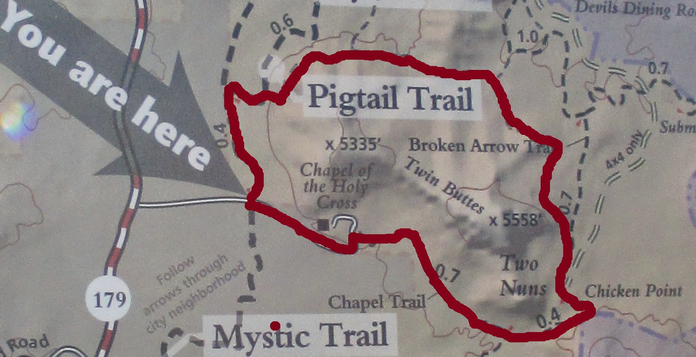
 The area is shown in
the map insert (right); the
junction of Margs Draw and Broken Arrow Trails is shown at top right
and I have placed a marker on what I believe to be Battlement Mesa.
The area is shown in
the map insert (right); the
junction of Margs Draw and Broken Arrow Trails is shown at top right
and I have placed a marker on what I believe to be Battlement Mesa. Although some flowering
plants stand out boldly as though to say, “stop and admire me,”
others are more modest, seeming to hide themselves like a shy child
hiding his face in his mother's skirt. We almost missed the small
yellow blossoms of the Wrights deer vetch (left) so well was it hidden
Although some flowering
plants stand out boldly as though to say, “stop and admire me,”
others are more modest, seeming to hide themselves like a shy child
hiding his face in his mother's skirt. We almost missed the small
yellow blossoms of the Wrights deer vetch (left) so well was it hidden