Although
we expect to hike sporadically in the high country during the summer,
a 31 May 2014 hike in Pivot Canyon was the last scheduled hike for
the season.
We
left Cottonwood at 0700, our normal starting time for May hikes, and
drove east on Hwy 260 for about 43 miles before turning left onto
Forest Road 144. The turnoff is just before you reach milepost 249;
in fact, one can actually read the numbers on the mile marker from
the turnoff. We traveled 1.8 miles on FR 144, turned left onto FR
149 and traveled 1.1 miles, turned right onto FR 142 and traveled 2.1
miles to the unmarked trailhead at Toms Creek. There is a wide
graveled area in the bottom of Pivot Canyon where FR 142 crosses Toms
Creek, providing ample parking.

 We
were greeted by a scattering of bright yellow primroses (right).
I have only seen these once before, on the Lower Cedar Bench Trail.
We
were greeted by a scattering of bright yellow primroses (right).
I have only seen these once before, on the Lower Cedar Bench Trail.
As
we continued the easy hike up the gently-sloping canyon, following an
ATV trail, I noted a beautiful young oak tree (left)
growing in isolation on the canyon floor and a thriving young aspen
(right). Later, in the upper
reaches of the canyon, I saw other young aspens along with the trunks
of old, mature dead ones.
Just
0.2 miles upstream from our stating point, an old road crosses the
canyon. This is where Toms Creek flows in from the left (southeast).
We didn't investigate the old road; however, it appears passable by
4-wheel drive vehicles. The main canyon at this point turns and
continues upstream to the west for about a mile to the mouth of Hicks
and Duncan Canyon (sometimes called Corduroy Wash because a wash of
that name joins Hicks and Duncan about 1.5 miles above). Pivot Rock
Canyon then turns and runs generally south for about 1.6 miles before
it turns to the southeast past Pivot Rock and then gently curves to
run northeast until it ends at Pivot Rock Spring.
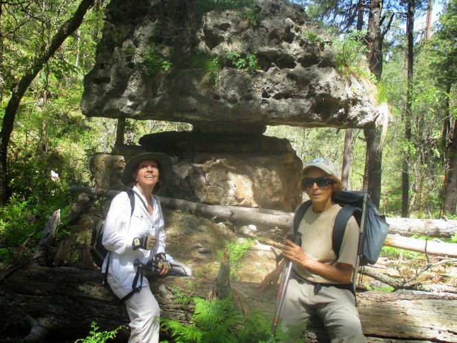
 About
1.5 miles from the trailhead at FR 142, there is an old settler's
cabin (left). That has, according
to Daisy Williams, who came this way several years ago, been
partially restored in recent years. We stopped there for a short
rest and to take a group photograph
About
1.5 miles from the trailhead at FR 142, there is an old settler's
cabin (left). That has, according
to Daisy Williams, who came this way several years ago, been
partially restored in recent years. We stopped there for a short
rest and to take a group photograph |
Left to right: Betty Wolters, Chris Jensen, Beverly Sass, Daisy Williams,
David Murrill, Lila Wright, Jim Manning and Joyce Arregui – photograph by
the author
|
Jim
Manning was hiking with a bad leg, having previously damaged a
muscle, and didn't intend to hike all the way to Pivot Spring. He
had anyway hiked the trail in April when we did a scouting hike. He
thus decided to stop off at the cabin, read a book for awhile, and
then return to the trailhead to wait for us.
About
0.1 mile upstream from the old cabin, what remains of Forest Road
9370 enters the canyon. This section of the road appears long
unused; however, it is still easily discernible as it leads steeply
up the canyon wall. As a matter of fact, we left the canyon by way
of this road when we did the scouting hike last month. It is still
posted as FR 9370 on the upper end.
After
another 0.6 miles upstream from FR 9307, we came to a parting of the
ways between the hiking trail and the ATV trail. As shown in the
below photograph, the ATV trail leaves the canyon bottom at this
point while the hiking trail continues up the canyon floor.
 |
| ATV trail leads to the right up the canyon wall; the hiking trail is straight ahead |
The
trail for the rest of the way is still very easy to follow although
in at least two instances ATV trails descend from the right canyon
wall. I followed one of those on the scouting hike and found that it
took me to an old road, still in use, that leads up a draw and back
down the other side to rejoin the trail.
From
this point the canyon closes in a bit but is still wide enough that
one can walk alongside the rocky streambed. The trail is almost
level and easy to hike. But about 0.4 miles from where the ATV trail
left the canyon floor and approximately where I returned to the trail
on the scouting hike after following the ATV trail, the canyon forks
and it is not really clear which branch is Pivot Rock Canyon. Just
remember that this is where the canyon turns southeast and take the
left branch.
 |
| Canyon fork – go left – do not take the path leading straight ahead |
At
this point, go directly up the left fork. The apparently well-trod
path leading up the slope between the two forks ends a few yards
ahead.
The
rock formation which gives the canyon its name lies just 0.1 mile,
ahead just above the trail on the left side. For the best view climb
the slope from the upstream side of the rock.
 |
| Pivot Rock – photographed in April 2014
We took a couple of photographs while at the rock.
|
 |
| The author – photo by Betty Wolters |
 |
| Joyce Arregui and Betty Wolters |
The
canyon floor this stretch was carpeted with a blanket of beautiful,
bright green ferns.
 |
| Upper Pivot Rock Canyon blanketed with ferns |
Just
upstream from Pivot Rock we found what remains of the rear passenger
compartment of an ancient automobile and wondered how in the world it
ever wound up at this inaccessible spot. The photograph below was taken in April 2014.
 |
| Remains of old automobile |
We
were now very near to Pivot Rock Spring where we expected to eat
lunch before turning back, so we moved right along.
When we arrived at the spring we found another party, a family group with several children, ranging from a couple of teenagers to a three-months old baby, was already there and were preparing to enter the cave from which the spring flows.
When we arrived at the spring we found another party, a family group with several children, ranging from a couple of teenagers to a three-months old baby, was already there and were preparing to enter the cave from which the spring flows.
 |
| Cave from which spring flows |
 |
| Hiker entering large chamber |
In contrast to the outside temperature, it was quite chilly inside the large chamber.
 |
| Inner chamber of cave at Pivot Rock Spring |
I am told that the cave
runs about an eight of a mile into the mountain and that one can
leave the inner chamber by one opening and return by another, making
a loop in the mountain. These entry and exit openings are pointed
out by the red arrows in the above photograph. We chose to defer
crawling through the loop to another day and climbed back out to eat
lunch.
We
had identified a several flowers during the April scouting hike. Now
a month later even more were in bloom and these were entirely
different than the April flowers. They are all included in the
following photographs, those from today's hike first, along with
notations as to when photographed.
 |
| Claret cup cactus – May 2014 |
 |
| Green gentian – May 2014 |
 |
| Thermopsis – May 2014 |
 |
| Bush pea (?) - May 2014 |
 |
| Wild rose – May 2014 |
 |
| Arizona honeysuckle – May 2014 |
The columbine (below),
was found growing in a naturally-formed flower pot located in a large
isolated boulder along the trail in the lower part of Pivot Rock
Canyon. Apparently there was just enough moisture to keep it alive.
It was photographed in May 2014
 |
| Columbine in natural flower pot - May 2014 |
 |
| Scrambled eggs – April 2014 |
 |
| Canadian violet – April 2014 |
 |
| Hookspur violet – April 2014 |
 |
| Creeping mahonia – April 2014 |
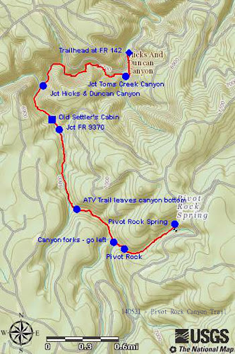
This was an easy hike.
The round trip distance was 6.6 miles, the trailhead elevation was
6685 feet and the elevation difference was only 372 feet.
Our GPS track is shown
in red on the included map (below). Points of interest discussed in the
narrative are also noted on the map.
No comments:
Post a Comment