Seventeen
Skyliner hikers set out to hike on Bell and Apache Maid Trails the
bright, sunny morning of 18 February 2012. Hikers from Cottonwood
met at the Safeway parking lot and carpooled to the Bell Trailhead;
those coming from Sedona met us there.
Apache
Maid Trailhead is located a little short of three miles up the trail
from the Bell Trailhead at Beaver Creek Ranger Station. A parking
lot (large but often filled) is located at the Bell Trailhead. To
reach it take I-17 to exit 298 (Hwy 179/FR 618), otherwise known as
the Sedona Interchange. From I-17 take FR 618 east for 1.5 miles to
the Beaver Creek Ranger Station turnoff (FR 618A). Turn left and
proceed 0.25 miles to parking area and trailhead. If the lot is
full, turn around and go back about 0.25 miles toward I-17 on FR 618
and then turn right to park at the Bell Trail Overflow Parking Lot.
You will have seen the sign on the way in. Toilet facilities are
provided at both parking lots.
Don’t’
even think about hiking on Bell Trail unless you want a lot of
company. It must be one of the most popular trails in the state. I
have never been on it without seeing several other hikers. Once
George and I came upon a Mexican lady struggling up the trail
carrying half a watermelon on a silver platter. She was taking it
along as refreshment for her family while they frolicked at the
swimming hole. Apache Maid, which starts about three miles from the
parking lot, is another matter. This is the second time I have hiked
on it without meeting anyone along the way.
Bell
Trail after leaving the parking lot on an old roadbed approaches and
then follows northeast along Wet Beaver Creek. Soon a school
(Southwestern Academy, Beaver Creek Ranch Campus) comes into
view across the creek.
Perhaps
a half-mile from the parking lot we came to the Bruce Brockett
Trailhead. I was told that this trail leads to the Bell Trail
overflow parking lot. According to the sign the lot is named Bruce
Brockett.
 That
would mean that the hiking distance would be approximately the same
whether one parked at the main trailhead or the overflow lot. The
photograph shown here (right) was
taken on the return trip and shows Bruce Brockett Trail leading up
the bank to the right. It is not shown on any maps that I have seen,
so I suppose it is relatively new.
That
would mean that the hiking distance would be approximately the same
whether one parked at the main trailhead or the overflow lot. The
photograph shown here (right) was
taken on the return trip and shows Bruce Brockett Trail leading up
the bank to the right. It is not shown on any maps that I have seen,
so I suppose it is relatively new.
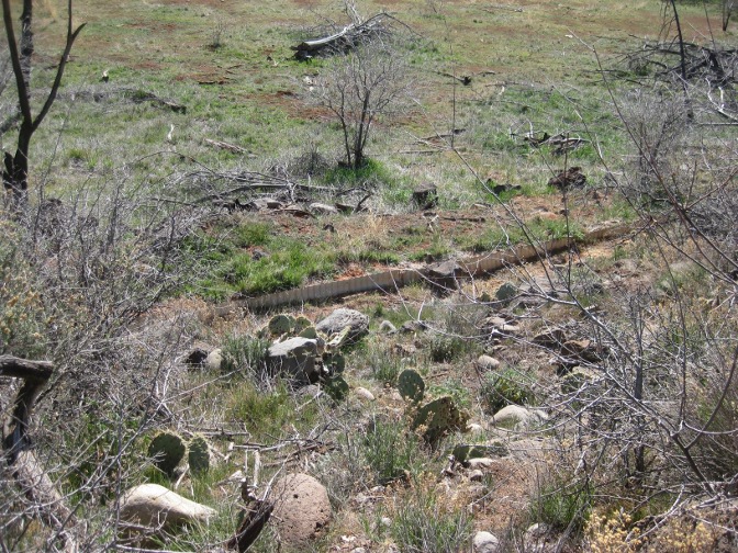
To
our right as we continued along the trail, the remains of an old
irrigation system were to be seen between the trail and the creek.
In places the system was just a ditch or canal.
 |
| Ditch or canal - part of irrigation system |
In other places it seems to have been constructed of plastic pipe.
 |
| Plastic pipe - part of irrigation system |
And even corrugated piping of the sort that is
commonly used for highway culverts.
 |
| Corrugated piping - part of irrigation system |
The
section of the system that was composed of just a ditch (or canal)
was unlined but in some places appears to have been reinforced by the
installation of metal sheeting on the lower side.
 |
| Reinforced section of open ditch |
The system seems to have been abandoned several years ago.
Just
under a mile along the trail we came to a petroglyph-covered rock beside the trail. Some of
the markings look suspiciously recent in origin. Whether others were
actually made by Indians I cannot say, but I think they probably
were.
 |
| Petroglyph-covered rock |
 About
another 0.8 miles along the trail we came to a trailhead marked White
Mesa Trail (left). I have never
been on this trail; however others have told me that it only goes a
short distance up on the mesa and ends.
About
another 0.8 miles along the trail we came to a trailhead marked White
Mesa Trail (left). I have never
been on this trail; however others have told me that it only goes a
short distance up on the mesa and ends.
Shortly
after passing the White Mesa Trailhead, we came to some Indian ruins
located alongside the trail and overlooking the creek just a few
yards away. Located as they are alongside the trail, which itself
follows an old road, they ruins have been picked over and pretty much
destroyed. About the most impressive thing that I saw along the
abandoned roadway was what is left of an old pit house.
 |
Ruins of an old pit house
|
Not
more than half a mile beyond the Indian ruins, we came to the Apache
Maid Trailhead and stopped for a snack. Apache Maid leads up to the
Mogollon Rim from here while Bell Trail continues along Wet Beaver
Creek, and some of our hikers wanted to go farther on Bell Trail
rather than climb to the rim.
Apache
Maid does look pretty scary from the bottom when standing at Bell
Trail looking up to the rim high above. After some discussion, we
split into two groups, a member of each group carrying a
walkie-talkie, and agreed to meet back at this point at 1300. The
walkie-talkies are a recent acquisition by the Skyliners and we were
trying them out on this hike. We have found that as the number of
hikers has grown, we often have a need to break into two groups and
this gives us a way to keep in touch in the event one of the groups
encounters a problem.
Before
parting ways, we paused for the obligatory group picture.
 |
Left to right: George Everman (kneeling), Jim Manning, Jan Prefontaine
(kneeling), Daisy Williams (kneeling), Connie Woolard, the author
(kneeling), Bill Woolard, Terri Johnson, Jan Johnson, Dolly Yapp
(kneeling), Lila Wright, Jo Benkendorf, Akemi Tomioka (kneeling),
David Beach, Becky Fowski, Mary Gavan and Karl Buckendahl
|

I
hiked with the group going to the rim on Apache Maid Trail. It is in
good shape all the way to the top and, as we had found out by hiking
the entire length of the trail starting at the base of Apache Maid
Mountain just a few weeks ago, the rest of Apache Maid is also in
pretty good condition. I was struck by the consistent grade of the
trail, accomplished by use of a lot of switchbacks. It hardly varied
all the way to the top. At the rim we encountered a weathered sign
(left) discouraging hikers from
continuing beyond this point. Those of us who had recently hiked the
trail thought it a bit misleading. Our experience was that it is
relatively easy to follow the entire length of the trail just by
paying attention to the wire-bound cairns placed along the way.
 We
had arrived at the top with plenty of time left to eat lunch and have
a quick nap before heading back to meet the others at the junction
with Bell Trail. I, of course, quickly dispensed with lunch and
settled in for my nap (right),
first unpacking and donning my windbreaker; it was a little breezy on
the rim. I slept a good thirty minutes before being awakened by the
noise of my cellphone alarm sounding. After I got home, George sent
me a picture, taken by Akemi during my nap.
We
had arrived at the top with plenty of time left to eat lunch and have
a quick nap before heading back to meet the others at the junction
with Bell Trail. I, of course, quickly dispensed with lunch and
settled in for my nap (right),
first unpacking and donning my windbreaker; it was a little breezy on
the rim. I slept a good thirty minutes before being awakened by the
noise of my cellphone alarm sounding. After I got home, George sent
me a picture, taken by Akemi during my nap.
The
views on the way up to the rim and from the top were the highlights
of this hike for me. A couple of shots are shown below.
 |
The San Francisco Peaks from Apache Trail at the edge of the Mogollon Rim
|
 |
Looking down Wet Beaver Creek, across Southwestern Academy and
on the distant mountains
|
The
hike turned out to be only a little over eight miles (GPS reading)
instead of the ten miles I had estimated. The section of Apache Maid
that we hiked was 1.8 miles by GPS with an elevation gain of 1100
feet. The section of Bell Trail that we hiked to get to Apache Maid
is essentially flat with around a 100-foot elevation gain.
Historical
Note:
Hike
Arizona.com (http://hikearizona.com/decoder.php?ZTN=384)
presents two possible sources for the name Apache Maid: One is that
troops, fighting Indians here in 1873, killed an Apache woman and
took her baby with them to the fort at Camp Verde. This is coupled
with an account that a young Apache girl came to the area with troops
from Camp Verde in 1874 and that the mountain was named after her.
Acceptance of this possibility thus requires the assumption that the
“baby” taken to Camp Verde by the troops the year before was
actually a young girl. The second possible source presented is that
Apache Maid was named after a lost and starving young Apache girl who
was adopted by one of the early settlers.
See
the included map (below)
for a track of this hike.

No comments:
Post a Comment