Becky
Fowsky, with her husband Frank, had reserved a group campsite at the
north rim of the Grand Canyon for 9 to 14 August 2012 and had invited
us to join them.
Kwi
and Lynn Johnson, Lila Wright, George Everman, Akemi Tomioka and
Ellis Price (the author) decided to join them there. Kwi and Lynn
planned to spend the entire five days at the campsite. Lila Wright
and Ellis Price would camp for only three days, returning on the
twelfth, and George and Akemi would not arrive until the eleventh.
I
rode with Lila who wanted to take her pickup because it has a camper
shell installed and she preferred that to sleeping in a tent. She
picked me up at home at 0700 and we took I-17 to Flagstaff, then
drove north on US Hwy 89.
When
we crossed the Little Colorado River at Cameron I noted that all the
saltcedar (tamarix) along the river was dead or dying. That seemed
strange as other plants appeared to be unaffected.
Continuing
on past Cameron, we came to an area with numerous small
conical-shaped formations that looked like giant ant hills. They
appeared to be formed of shale. A medium Gray (or lead gray) in
color, they appeared at first glance to be piles of gravel, such as
might be used in highway construction or repair. However, they were
too numerous and randomly dispersed for that.
We
passed the turnoff to Tuba City (despite the signs extolling the
town's wonders and encouraging us to visit) and continued on to US
Hwy 89A where we turned to cross the Colorado River at Marble Canyon,
just south of Lees Ferry.
Lees
Ferry was established by John D Lee,
a Mormon settler with seventeen wives, in 1871. The ferry served as
the only place to cross the river until Navajo Bridge, funded by the
Arizona Highway Commission and the Bureau of Indian Affairs, opened
in 1929. Having become a part US Hwy 89A, Navajo Bridge was later
deemed inadequate for that service, and was replaced in 1995. The
old bridge remains, open to pedestrian and equestrian use, as part of
the Navajo Bridge Interpretive Center. It was placed on the National
Register of Historic Places in 1981.
We
stopped at the interpretive center to look around and walk across the
old bridge. We noted that the saltcedar along the streambed of the
Colorado was, like that at the Little Colorado, dead. Lila asked the
attendant at the interpretive center whether she knew who had treated
the treated the plants and how they had managed to selectively kill
only the saltcedar on such a wide basis. She did not.
 |
The Colorado River from Navajo Bridge
|
We
had planned to eat lunch at Cliffhouse Restaurant in Marble Canyon at
the base of the the Vermilion Cliffs. However, it was entirely too
early when we arrived, and we decided to drive on to Jacob Lake. We
arrived there just as they were opening the main dining room for
lunch and had our choice of seating. Looking around we found the
walls adorned with paintings, photographs, and various objects of art
for sale.
Superimposed
on all this was Christmas decorations, and then I noticed that
Christmas music was playing in the background. On questioning our
waiter, we found that one group of college student workers, soon due
back at school for classes, was being relieved by another group on a
different school schedule, and that they had decided to have three
days of Christmas during the shift overlap. They even had a
Christmas tree in the main lobby.
The
food selection was good, with items for every palate, even
vegetarians. The service was pleasant and reasonably fast, and the
food quality was excellent. We were soon on our way, pleasantly full
and hoping that we might come this way again sometime.
The
drive from Jacob Lake Inn Restaurant to our campsite in the Grand
Canyon National Park is just over 42 miles along State Highway 67.
On the way we noted that the forest was recovering from a fire that
must have occurred several years ago. The hills were covered with
young aspen trees, and I wondered if they had all sprung up from the
extensive root systems of the burned trees; I had been told that the
aspen propagated itself this way, and that groups of trees were
called clones. However, I have since learned that they also
propagate by reseeding in the normal way. I have no idea which
method predominated in the burned over area we saw.
We
arrived at the North Rim Campground (Transept Trail Campground) at
about 1330, checked in with the ranger on duty, and after some
driving around looking for our assigned group campsite, were flagged
down by Kwi and Lynn who had arrived early and were all set up. We
immediately set up our tents. Lila still intended to sleep in her
truck, but set up a small tent in case the ranger questioned us. It
was, after all, billed as tent camping only. However, we were
allowed to have three vehicles at the twenty-tent site, and we saw
nothing wrong with her sleeping in one of them.
 |
The author's tent.
|
We
checked out the campsite and found a well-stocked store with a coffee
bar and wi-fi. There was also a self-service laundry and pay shower
($1.50 for 5 to 7 minutes). A drinking water spigot was provided at
the campsite. You might say that we had all the comforts of home.
Widforss
Trail
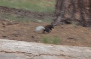 On
Friday morning as we ate breakfast and prepared for our first day at
the North Rim, we were greeted by a multitude of ground squirrels
just waiting for us to leave camp so that they could scavenge through
our belongings. A fat raven perched on a bare tree branch nearby,
greeted us with a cheeky “squawk, squawk” and assured us that he
would look after things while we went hiking. At least that's what I
thought he was saying. Meanwhile, an uppity Kaibab squirrel
(photograph by Kwi, above right)
flashed his gleaming white tail as he scampered around nearby, nose
in the air, muttering to himself, “if that riffraff will ever
leave, I'll check and see what tribute they have brought for me.”
On
Friday morning as we ate breakfast and prepared for our first day at
the North Rim, we were greeted by a multitude of ground squirrels
just waiting for us to leave camp so that they could scavenge through
our belongings. A fat raven perched on a bare tree branch nearby,
greeted us with a cheeky “squawk, squawk” and assured us that he
would look after things while we went hiking. At least that's what I
thought he was saying. Meanwhile, an uppity Kaibab squirrel
(photograph by Kwi, above right)
flashed his gleaming white tail as he scampered around nearby, nose
in the air, muttering to himself, “if that riffraff will ever
leave, I'll check and see what tribute they have brought for me.”
Finally,
having finished our breakfast, cleaned up and stowed our gear for the
day and fastened our tents securely (or so we thought), we left our
belongings in the promised care of the noisy raven and departed for
the Widforss Trail.
From
the campsite, we Drove about 150 yards out to the main road (Hwy 67),
turned left (generally north) and followed that paved road for about
nine-tenths of a mile before turning left onto an unpaved road that
took us along the edge of Harvey Meadow to the Widforss Trailhead,
around another seven-tenths of a mile from Road 67. Trailhead
parking was ample and toilet facilities were available.
A
Trailhead Sign noted that the trail was named after, “Gunnar M.
Widforss who painted landscapes in the national parks of the West
during the 1920s and 1930s.” The sign goes on to describe the
trail as follows:
The Widforss Trail
follows the canyon rim as it skirts the Transept, a large tributary
gorge of Bright angel Canyon. The trail winds through a mixed
spruce-fir forest to a picnic area near Widforss Point overlooking
Haunted Canyon.
A
pamphlet, available from a trailhead trailhead box. identifies
fourteen specific viewpoints marked by numbered posts along the first
2.5 miles of the trail. This is the “guided hike” section of the
trail and, I am sure that many hikers turn back at that point. The
trail does, after all, turn away from the rim and the great canyon
views there.
We
left the trailhead heading in a southwest direction. This took us,
in a fairly steep climb, up the slope to the Kaibab Plateau. As we
climbed we soon came to an area where a forest fire had raged some
years ago. Most of the damage had occurred to the right of the
trail, that is to our northwest as we moved along the trail.
Although, I am sure the canyon rim must have served as a firebreak,
even when we were not right on the rim, almost all the was damage was
to our right. In the photograph shown below, damage appears to have
been relatively light close up, becoming more severe farther away.
 |
Fire damage along the Widforss Trail
|
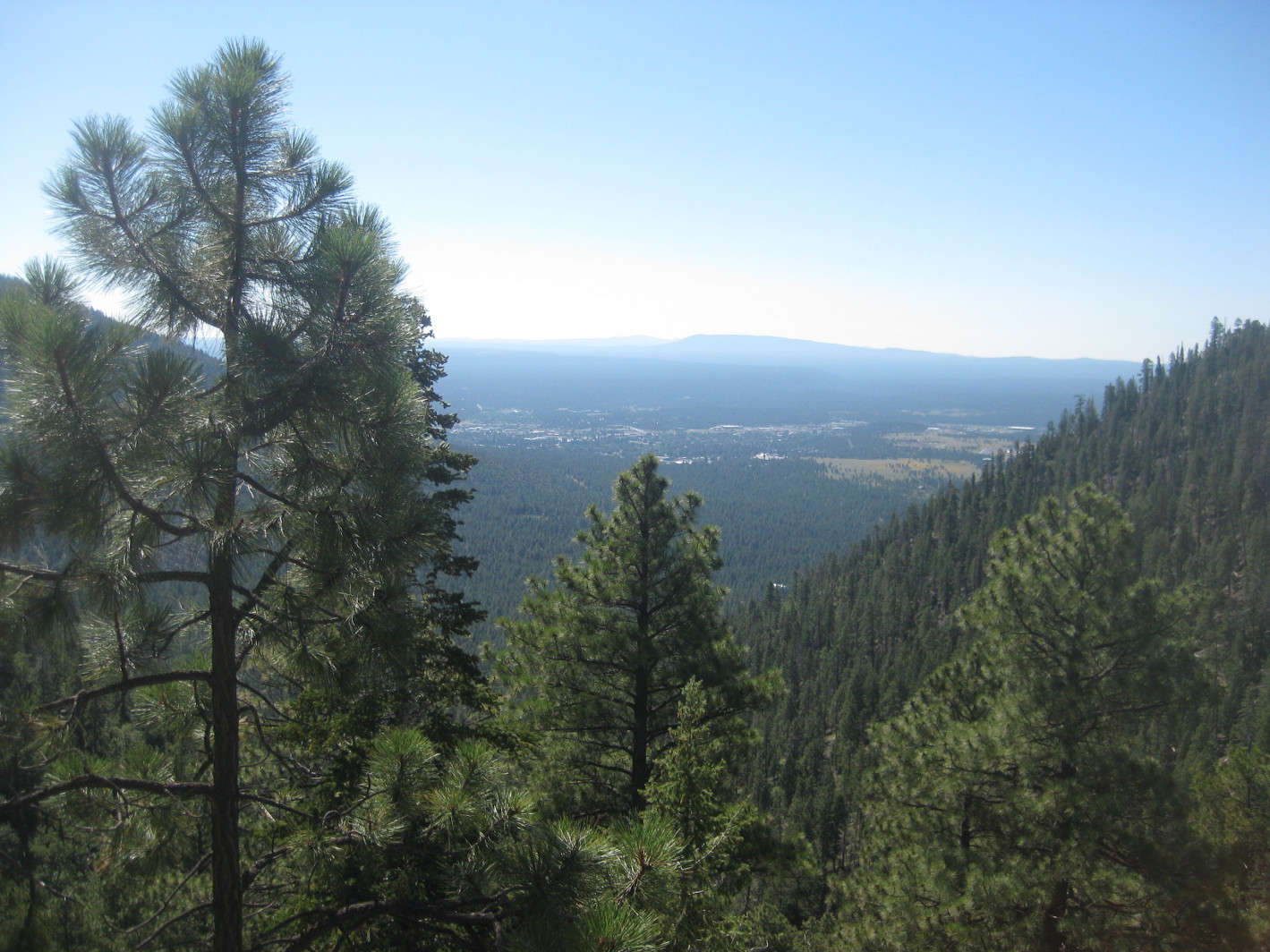
A
little farther along, at marker 5, we got our first good look down
into Transept Canyon and the view across Grand Canyon to the San
Francisco Peaks 70 miles beyond.
 |
Looking down Transept Canyon to Bright angel Canyon – On the horizon,
the San Francisco Peaks, 70 miles away, are faintly visible through the
haze (see right of center)
|
We
could not see the Colorado River itself from the trail because it was
beyond the far wall of Bright Angel Canyon into which Transept feeds,
apparently at an angle leading to the name Transept. I had some
trouble with that name as applied here because I usually visualize a
transept as a structural part of a cathedral running transverse to
and across the main structure. By comparison, Transept Canyon would
seem to form form only a semi-transept with Bright Angel Canyon.
As
we continued along the rim above Transept Canyon we enjoyed
ever-differing views of the canyon below.
 |
The outcropping just to left of center is Oza Butte
|
Some
of our group paused long enough for a photograph at the rim.
 |
Lila Wright, Betty Fowsky and Kwi Johnson, along with two unknown hikers
|
On
a section of the trail that jogged away from the rim to cross a wash,
we came to a large ponderosa pine growing directly in the middle of
the trail. The trail brochure said it was “nearly 13 feet in
circumference” and “one of the largest ponderosa pines
along the Widforss Trail.”
 |
Large ponderosa in the middle of the trail
|
As
we continued along the trail beyond the “guided trail” portion,
we continued to observe fire damaged forest. Also clearly
demonstrated was the natural process of recovery. Note the variety
of plant life demonstrated in the photograph below. As you can see
the aspen are making a strong comeback in this area. I have learned
that this tree propagates itself by cloning (or sprouting from an
extensive root system) and by reseeding. I have no idea which method
predominates here. Whatever the method, fresh-growth aspen trees
were even more noticeable in the burned-over forest along Hwy 67 on
the way to the park.
 |
Fresh growth in burned-over forest with aspen trees predominating
|
Along
the way we came upon a log showing the artful designs drawn by
insects burrowing under the bark of dead trees.
 |
Designs in a log drawn by artistic insects.
|
After
about two and a-half miles the trail veered away from the rim and we
were soon in a more open section section of forest. Patches of
flowers bordered the trail along the way.
 |
Asters blooming alongside the trail
|
The
last section of the trail sloped gently downhill to Widforss Point
where we found a picnic table awaiting us.
 |
Picnic table at the end of Widforss Trail
|
Deciding
not to eat our lunch at the table, we continued to a grass-covered,
tree-shaded spot on an open slope about 100 yards ahead.
The
actual location of Widforss Point, as shown in the below photograph,
was about a quarter of a mile ahead.
 |
Looking ahead at Widforss Point
|
We
had great views all around from our lunch spot and were positioned on
a soft mat of grass with a gently wind blowing to keep us cool. No
one was in a hurry to leave, so we lingered for a good while before
heading back.
For
the return trip, we had a choice of returning exactly the way we had
come or of taking a short loop that skirts the drainage to the east
of the trail we came in on. We split into two groups, some going one
way the rest the other. As I returned the way we had hiked in and
was carrying the GPS, our track on the map included in this report
does not show the loop.
A
short way up the trail, I found a large patch of Indian paintbrush
along the way that I had somehow missed on the way in.
 |
Indian paintbrush in bloom along the trail
|
We
started to meet other hikers now, all wanting to know how much
farther it was to the end of the trail. We stopped and chatted for
several minutes with a family from Belgium.
When
we arrived back at the rim above Transept Canyon, I found a suitable
vantage point for a photograph showing the wash running down the
bottom of the canyon all the way to Bright Angel Canyon.
 |
Looking down Transept Canyon to Bright Angel Canyon
|
The
difference in elevation between the highest and lowest points on the
trail was (according to my GPS) only just over 500 feet. However,
the total ascent, considering all the ups and downs along the way,
was closer to 1300 feet. The round trip distance was 10 miles as
advertised.
When
we got back to the campground, we found that the ground squirrels had
invaded the Johnson's tent and made a mess of things. So much for
the raven's assurances. Or did I just misunderstand what he was
saying that morning?
The
red track on the map included in this report (below) shows our GPS track for the hike. The
yellow track shows the route we drove from the campground to the
trailhead.
Hike Cape Final Trail/Visit Greenland
Lake,Vista Encantada, Roosevelt Point, Walhalla Overlook, Cape Royal
and Point Imperial
We
got up early on Saturday morning and set out to visit Point Imperial,
the viewpoints along the rim of Walhalla Plateau, and hike Cape
Final Trail to Cape Final.
Our
first stop was Greenland Lake, described as shown on the below sign.
The bottom photograph shows its present appearance.
 |
How Greenland Lake was formed.
|
 |
Left to right: Becky Fowsky, Kwi Johnson and Lila Wright in Greenland Lake
|
Not
lingering at the lake, we headed to Vista Encantada, our first real
Grand Canyon viewing point, where we would be able to look out over
the canyon.
When
we arrived at Vista Encantada. rain was threatening at the rim and we
could see that it was actually raining at places in the canyon;
however, looking on across the canyon, the sun was shining on the far
mountains.
 |
Looking across the Grand Canyon to the sun-drenched mountains beyond
|
Since
our plans for the day included a four-mile hike on Cape Final Trail
and, with some of the group actually hoping to do the five-mile Uncle
Jim Trail before the day was done, we quickly finished our viewing,
returned to the car and headed for our next stop, Roosevelt Point.
An
informational sign was posted at Roosevelt Point identifying some
features of the scene laid out before us.
 |
Section of sign showing Echo Hills, Navajo Mountain and the Navajo
Reservation
|
 |
Section of sign showing location of the Little Colorado River Gorge
|
 |
Wording on the informational sign at Roosevelt Point
|
The following graphic, from the same
informational sign, shows the Hopi Reservation and the part of the
Navajo Reservation that can be seen from Roosevelt Point.
 |
Navajo and Hopi Reservation lands visible from Roosevelt Point
|
The following
photograph was taken
looking toward Navajo Mountain. However, Navajo Mountain along with
Echo Cliffs and other distant topographical features are obscured in
the photograph by a series of rain squalls spread across the canyon.
 |
Roosevelt Point - Looking toward Navajo Mountain – rain in the canyon
is obscuring the mountain
|
Our next stop was Cape
Final Trail. It was now looking very much like rain, but we found
such a glorious display of flowers scattered along the trail that we
just had to continue the hike.
 |
Skyrocket (or scarlet gilia) at Cape Final Trailhead and along the trail
|
The trail led us up a
gentle slope for 1.3 miles to the rim at Viewpoint 1
and our first good view of the canyon from Cape Final. The most
awe-inspiring view for me was looking directly down for several
hundred feet from the head of the canyon below us. The presently-dry
wash visible running down the canyon in the below photograph dumps
into Lava Creek which feeds into the Colorado River through Lava
Canyon.
 |
Looking down into a canyon that feeds into Lava Creek
|
The sky was now
beginning to clear and views were improving. The downside of that
was, of course, that the intense August sun was now bearing directly
down on us, unfiltered by cloud cover. Fortunately, much of Cape
Final Trail is sheltered by trees and, being on the rim, we had a
good breeze most of the time. All in all it was still very pleasant
hiking, as we left Viewpoint 1 and headed for Viewpoint 2,
three-tenths of a mile away.
In the photograph shown
below, taken at Viewpoint 2, one can see the cliffs (center
horizon) in Vermilion Cliffs National Monument. It
was interesting to reflect that we had driven past and admired these
same cliffs just two days previously after crossing the Colorado at
Marble Canyon. There was still some rain activity between our
viewpoint and the cliffs, so they are not shown as clear as they
might have been.
 |
View of the Grand Canyon with the Vermilion Cliffs visible in the distance
|
Leaving Viewpoint 2, we
hiked another four-tenths of a mile to Viewpoint 3. From there, we
got a glimpse of the Colorado River deep in the canyon, about a mile
below us and eight miles away. Judging from reference to Google
Earth, the small section of the river visible slightly to the right
of and above center in the following photograph is at Awatubi Canyon,
a little over three miles upstream from the Little Colorado River
junction.
 |
A glimpse of the Colorado River a mile below us and eight miles away
|
Juno Temple is also
visible in the above photograph; see the circular formation at right,
just above center.
 Viewpoint 3 is only
about 160 yards from the end of the trail at the very tip of the cape
(labeled VP4 on the included map).
From where we stood we could see two other hikers who had preceded us
on the trail and were already there enjoying the view. We continued
on to join them there. The final climb up a slight slope to
Viewpoint 4 was helpfully marked by a small sign (see
right).
Viewpoint 3 is only
about 160 yards from the end of the trail at the very tip of the cape
(labeled VP4 on the included map).
From where we stood we could see two other hikers who had preceded us
on the trail and were already there enjoying the view. We continued
on to join them there. The final climb up a slight slope to
Viewpoint 4 was helpfully marked by a small sign (see
right).
 The point was marked by
several survey markers, the latest (left)
having been installed in 1934. I took pictures of them all, but
later discarded everything that was dated before 1934.
The point was marked by
several survey markers, the latest (left)
having been installed in 1934. I took pictures of them all, but
later discarded everything that was dated before 1934.
The two hikers we had
seen from our last stop were still at the cape when we arrived and
proved to be a very friendly couple. We visited with them for a few
minutes before they went on their.
Before leaving one of
the friendly hikers offered to take a picture of us standing on the
rim with the canyon as a background.
 |
Left to right: Becky Fowsky, Kwi Johnson, Lila Wright and the author
|
We took two additional
photographs (below) from
Viewpoint 4.
 |
Looking across the canyon from the tip of Cape Final, Viewpoint 4
|
 |
Looking down into the canyon from the tip of Cape Final, Viewpoint 4
|
Leaving our perch on
the tip of Cape Final, we returned along the trail the way we had
come, marveling anew at the flowers strewn along the trail. The two
pictures shown below were taken by Akemi Tomioka on a 13 August hike
and forwarded by George Everman.
 |
Skyrocket (or scarlet gilia) alongside Cape Final Trail
|
 |
Skyrockets, Indian paintbrush and other flowers alongside road to
Cape Final Trail
|
Leaving Cape Final
Trail behind, we loaded into our car and headed on to Cape Royal.
Just before reaching Cape Royal we stopped at Walhalla Overlook to
get a look through Angels window.
 |
Looking through Angels Window from Walhalla Overlook
|
We then continued along
the road for a short distance, parked at Cape Royal and walked out on
top of Angels window.
 |
From atop Angels Window – the Colorado River is visible below
|
Leaving Angels window,
we walked the short distance the Cape Royal viewpoint where the two
below photographs were taken.
 |
Looking down into the canyon from Cape Royal
|
 |
Looking across the canyon from Cape Royal
|
Our next stop would be
Point Imperial which turned out to be a most pleasant site with
expansive parking, toilet facilities, shade and benches. Here we
enjoyed what I thought were the best views of the day. See the
following three photographs.
 |
Looking into the canyon from Point Imperial
|
 |
Looking across the canyon from Imperial Point
|
 |
From Imperial Point
|
We paused to eat lunch
before leaving this excellent spot.
 |
Eating lunch and enjoying the view at Imperial Point are, Left to right:
Kwi Johnson, Becky Fowsky, Lila Wright, Ellis Price and Lynn Johnson (Lynn
had joined us at the end of the hike on Cape Final Trail)
- photograph courtesy of a passerby
|
After lunch, we
returned to the campground where I took a leisurely shower, shaved
and made myself comfortable for the rest of the day.
We had gotten up at
0530 to get an early start for today's activities and I was ready for
some down time. I have a strong aversion to tight schedules under
any circumstances, and this is especially true for vacation and
leisure activities. While the rest of the hikers in the group were
busy arranging to get up early again the next morning so they could
hike the Uncle Jim Trail before Lila and I departed for home, I had
already decided that I would sleep in instead. Uncle Jim would have
to wait for another day when I was in the mood.
Later that evening
George Everman and Akemi Tomioka joined us and we all had a pleasant
evening around the campfire.
 |
I will not attempt to identify the campers shown here as I really can't
make out the faces – photograph by Lynn or Kwi (I am not really sure which)
|
The included map (below) shows only the trail we hiked, that is Cape Final Trail. The rest of our travels to and between viewpoints was by automobile on paved roads.
Hike
Uncle Jim Trail and Return Home
On
Sunday, 12 August 2012, George, Becky, Kwi, Lila and Akemi got up
early and set out to hike the Uncle Jim Trail before it got hot and
in time for Lila to leave before 1000. We wanted to be at the Bison
Viewing Area on the way out of the park at 1000 because we had been
told that was the most likely time for them to be out.
Below
is a photograph of the Sunday morning hikers.
 |
Becky Fowsky, Kwi Johnson, Lila Wright and Akemi Tomioka
(photograph by George – not shown)
|
 The
hikers found a number of fossils on Uncle Jim Trail. A good example
is displayed in the photograph shown here (right – Photograph by Akemi Tomioka).
The
hikers found a number of fossils on Uncle Jim Trail. A good example
is displayed in the photograph shown here (right – Photograph by Akemi Tomioka).
Lila
and I headed home immediately after the hike, Kwi and Lynn left
later that same day, and George and Akemi stayed on until Tuesday to
hike the Cape Final and Widforss Trails and visit some more of the
scenic areas. George provided the following photographs taken after
Lila and I left.
 |
Monday evening rainbow (13 August 2012) – photo by Akemi Tomioka
|
 |
Monday Evening Sunset (13 August 2012) – photograph by Akemi Tomioka
|
 Before leaving for home
on Tuesday, George and Akemi hiked on the Widforss Trail where they
found the horned toad shown here (Left - photograph by
Akemi Tomioka). Note how well it blends into
the background.
Before leaving for home
on Tuesday, George and Akemi hiked on the Widforss Trail where they
found the horned toad shown here (Left - photograph by
Akemi Tomioka). Note how well it blends into
the background.
Meanwhile, Lila and I,
having gotten to Marble Canyon too early to eat lunch at Cliffhouse
Restaurant on the way to the campground, thought that if we were at
the Bison Viewing Area at 1000 that would just about enable us to
reach the restaurant in time for lunch on the way back home. Our
calculations were correct and we were right on time for lunch.
Lunch at the Cliffhouse
Restaurant turned out to be every bit as good as our meal at Jacob
Lake had been three days before. I had a delicious beanburger with
an excellent salad. The portions were such that I was unable to eat
it all, so I had them pack up part of my burger to take home. It
made a great lunch the next day.
As we had driven along
the Vermilion Cliffs, I had been watching for the distinct lead-gray
colored shale that we had seen in the “ant hill-like” formations
we had noted above Cameron. I had by now decided that they were
formed from a layer of shale with a harder rock layer overlying it.
It seemed to me that the protective overlying layer had eroded away
unevenly leaving small areas (caps) protecting the softer shale layer
underneath, while the surrounding unprotected shale rapidly eroded
away. Meanwhile, the isolated protective caps steadily eroded
becoming smaller and smaller, until they were finally gone, leaving
the ant-hill shaped piles of shale, which, now fully exposed to rain
and wind, were in turn rapidly eroding away.
While
at the Grand Canyon, I had noted a lead-gray layer called Bright
Angel Shale, laid down about 515,000,000 years ago, and now centered
around the 5000 foot elevation level. The same color of rock is seen
in outcroppings at that approximate elevation along the Vermilion
Cliffs and in the cliffs just east of the Colorado River crossing at
Marble Canyon. Meanwhile, the place where we had seen the ant-hill
like formations above Cameron was between 4000 and 5000 feet in
elevation. I have also seen the same color of shale in the lower
part of Paria Canyon, in the White Mountains near Fossil Creek and in
New Mexico between Farmington and Gallup, in this case in the same
ant-hill-like formations we saw above Cameron.
 |
Lead-colored shale layer in cliffs east of Colorado River at Marble Canyon
Crossing
|
On the way to the
campsite, I had noted some of the formations with tiny caps still
perched on them; however, I was unable to spot a good spot to stop
for a picture of one of those on the way back. The pictures shown
below are the best I could do.
 |
Ant-hill shaped piles of shale, possibly created when an overlying layer
eroded away
|
The below photograph is
a close-up of the shale that composes the formations. You can scoop
it up and crumble it with your hands. In fact, I brought a sample
home with me in a baggie.
 |
Shale that forms the ant-hill shapes
|
We made good time and
were home for an early dinner.