Seventeen Skyliners
hiked the Twin Buttes Loop in Sedona on 14 March 2015. This hike,
consisting of a combination of trails, can be performed in a
clockwise direction, as we did, or in a counterclockwise direction.
We parked alongside Chapel Road at the Mystic Trailhead and headed
north on Mystic Trail. The hike consists of a series of bike trails
or parts of trails (Mystic, Piglet, Hog Wash, High on the Hog, Hog
Heaven, Broken Arrow, Little Horse and Chapel). This route is shown
in red on the below excerpt from a Forest Service map posted at the
trailhead.
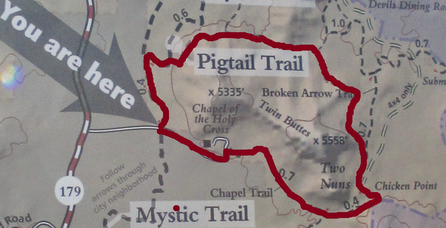 |
The route we took is shown in red on the above map
|
 From
the hike described here, we made one
significant deviation. We followed a social trail that climbs
steeply up the butte behind the Chapel to a small cave (right).
It is a steep, precarious climb along a faint trail that rises
almost 200 feet in 0.1 miles. The cave (or perhaps tunnel, as it has
an opening at either end) is only about 30 feet long and small
enough that one can barely squeeze through with a pack on.
From
the hike described here, we made one
significant deviation. We followed a social trail that climbs
steeply up the butte behind the Chapel to a small cave (right).
It is a steep, precarious climb along a faint trail that rises
almost 200 feet in 0.1 miles. The cave (or perhaps tunnel, as it has
an opening at either end) is only about 30 feet long and small
enough that one can barely squeeze through with a pack on. George
is shown here (left)
exiting
the cave. Having assumed the role of tailgater for the hike, he was
bringing up the rear. I do not recommend a climb to the cave as a
part of this hike. It is a lot of effort for a climb through a short
cave. Some of us climbed through the cave and returned to the trail
by a different route; others just looked and returned the way they
had come.
George
is shown here (left)
exiting
the cave. Having assumed the role of tailgater for the hike, he was
bringing up the rear. I do not recommend a climb to the cave as a
part of this hike. It is a lot of effort for a climb through a short
cave. Some of us climbed through the cave and returned to the trail
by a different route; others just looked and returned the way they
had come.
From
our position high on the shoulder of the butte, we had an excellent
view of Cathedral Rock across the valley.
 |
View of Cathedral Rock
|
We
returned to the trail and continued on our way around Twin Buttes.
The
trails were well-marked and posted with signs (right).
The signs warned bikers of the level of difficulty ahead. We had
long since learned that a trail rated as difficult for bikers would
require a great deal of care from hikers. On the other hand, the
very fact that a trail is rated as navigable for bikers tends to put
a certain limit on just how difficult it can be.

We
wanted to make it to the saddle north of Twin Buttes for our
midmorning snack and, as a result, delayed our snack a bit longer
than we should have. By the time we reached the saddle, I was
feeling quite ready for a rest. As a matter of fact, I even managed
to get in a short nap.
A
single cloud floated high in the sky above the distant mountains and,
except for the occasional short, steep climb, hiking was easy. The
views, meanwhile, were such as to cause one to pay too much attention
to the scenery and too little to footing.
 |
Panoramic view visible from the north slope of Twin Buttes
|
From the saddle where
we stopped to snack we could look down on Submarine Rock and,
although we couldn't pick it out, the location of Devil's Dining
Room. A steady stream of jeeps were to be seen carrying tourists
along the jeep trail that runs from Morgan Road to Devils dining
Room, Submarine Rock and on to Chicken Point. While at the saddle we
also saw other hikers and bikers for the first time on this hike.
Traffic then picked up steadily for the rest of the hike but never
became heavy enough to be a real problem.
The
trees along the way included junipers, Arizona cypress, manzanita,
ceanothus and crucifixion thorn. Because of the recent rains and the
arrival of spring growth, the plants were arrayed in various shades
of green ranging from the feathery, delicate hues of new growth to
the darker shades of maturity. The various shades of green stood in
stark contrast to the surrounding red rocks, but together they were
quite pleasing to the eye.

Few
flowers were to be seen along the trail on this hike, a fact that
made a single ceanothus (left)
in full bloom a striking sight.
 We
arrived at Chicken Point to find it a very busy place. There were
several groups of individuals who had driven their own vehicles in
and were just basking in the sun on the bare rock surface, eating
lunch or simply enjoying the view. I found a sunny spot on the rock,
ate my lunch and settled in for a nap. George and Akemi had
previously climbed along a narrow white line (hardly wide enough to
be called a ledge) in the cliff above (right)
and George decided to climb back to it while I napped.
We
arrived at Chicken Point to find it a very busy place. There were
several groups of individuals who had driven their own vehicles in
and were just basking in the sun on the bare rock surface, eating
lunch or simply enjoying the view. I found a sunny spot on the rock,
ate my lunch and settled in for a nap. George and Akemi had
previously climbed along a narrow white line (hardly wide enough to
be called a ledge) in the cliff above (right)
and George decided to climb back to it while I napped.
When
George had returned from his adventure and I had awakened from my
nap, we all gathered for a group photograph.
 |
| Left to right: James McGinnis, Ellen Mcginnis, Joyce Arregui, the author, Akemi Tomioka (front), Anita Jackson, George Everman (front), Connie Woolard, Donna Goodman, Daisy Williams, Karl Sink, Collene Maktenieks, Frank Lombardo, Jim Manning, Tim Wolters and Betty Wolters – photograph by Name Withheld |
As
we left Chicken Point we had a view of the terrain ahead from
Courthouse Butte on the left to Cathedral Rock on the right.
 |
Courthouse Butte, Bell Rock, Unnamed Mountain and Cathedral Rock
|
From Chicken Point it
is just 0.4 miles along Little Horse Trail to Chapel Trail and then
another 0.7 miles to the end of the trail at the chapel parking lot.
From the end of Chapel Trail back to our starting point at Mystic
Trail is only another 0.4 miles, this along a paved road.

At
the end of Chapel Trail we encountered an automatically-closing gate
(left). That is a very handy
arrangement as one doesn't have to fumble around closing and latching
the gate after passing through. Just push it open, pass through and
let it go.
 On
the other side of the gate was posted a very puzzling sign (right).
Since this very obviously is a trailhead, being one end of the
Chapel Trail and with two signs posted just beyond the gate to
identify it as such, one is left to wonder what the sign really
means.
On
the other side of the gate was posted a very puzzling sign (right).
Since this very obviously is a trailhead, being one end of the
Chapel Trail and with two signs posted just beyond the gate to
identify it as such, one is left to wonder what the sign really
means.
My
GPS track shows a hiking distance of 4.2 miles for the loop with a
maximum elevation of 4629 feet and a total ascent of 1016 feet. We
hiked an additional 0.2 miles and climbed an additional 185 feet to
visit the cave. The
GPS track for the loop hike is shown in red on the attached map (below).
For
those who might be interested, an interactive Bike Trail Map of the
area is available at:
http://www.trailforks.com/map/?lat=34.831287579117884&lon=-111.7570010023071&z=15&m=roadmap

No comments:
Post a Comment