Friday, February 24, 2017

Camp Verde Cliff Dwellings


On 4 February 2017 thirteen Skyliners (Jim Manning, Jim Gibson, Mark Purcell, Karl Sink, Glen Sperry, Ellen McGinnis, Jim McGinnis, Joanne Hennings, Joyce Arregui, Theresa [last name unknown], Daisy Williams, Anita Jackson, and Frank Lombardo) drove through Camp Verde on Hwy 260 and parked on the left side of the road at mile marker 225.4. The trail leaves the road through a permanently closed gate of heavy pipe. There is room at this location to park 5 or 6 cars. This parking area is arrived at before reaching Clear Creek. It is necessary to pass through the closed gate by climbing between two widely spaced pipes.

Even though, we were really close to highway traffic we found that bushes nearby were adequate cover for a restroom stop before starting out on the trail. Caves up high on a cliff are visible from the beginning of this well-traveled but unnamed trail. This hike includes both cliff dwellings and other (pithouse) ruins. Fifteen Skyliners had hiked here on 12 February 2011. A few of today's hikers had been on that previous hike.

In 2011 I had been the last hiker to finish the climb up to the caves, the last few hundred feet of which is very steep, requiring some hard climbing to reach the first of the cave dwellings. The others that day had already left the cave area when I arrived and I only had time to take a couple of photos before hurrying to follow them. So I was really glad that this time our leader, Jim Manning, gave us about twenty minutes to explore all the caves that I had bypassed before.

This Photograph (right) shows stone and mortar partial enclosure of a cliff dwelling and includes hikers Theresa and Anita.

Just below the cliff dwelling shown here I saw and photographed two substantial pottery fragments (below left). We found many other potsherds scattered in various locations at this site. In keeping with the custom for such locations, we just examined and photographed them and left them in place for others to enjoy. A second cave with stone and mortar enclosure is shown here (below right).

Pottery shards below dwellings                    Dwelling with a mortared opening
Below Anita Jackson and Karl Sink are shown still exploring a cave while Glen Sperry and Jim McGinnis are departing.

Anita, Karl, Glen and Jim exploring a cliff dwelling
From the cave area we made our way on up to the top of the mesa where we found a deep, narrow chasm (left) separating two unequal parts of the mesa. The smaller part of the mesa where we went next was covered with ruins. The ruins were circles of low rock walls like the ruins of pit houses. To reach them we had to climb up over some larger rocks on the way up. A good example of these ruins is seen in the photograph below which shows Ellen McGinnis sharing a particularly impressive pottery shard with Frank Lombardo while Jim McGinnis quenches his thirst.

Ellen, Jim and Frank standing in the ruins atop the mesa
Ellen placed the pottery shard back atop the rock where she found it (below right). Note that the fragment, shown below, has a part of the rim still attached and a piece of corncob is located nearby.

Looking back on the caves
 in the wall of the mesa
Looking back from the ruins atop the mesa, we could see the caves below (left) along which we had followed the trail on the way up.

Leaving the smaller part of the mesa where the Indian ruins were located, we crossed the chasm that separates the two parts and hiked uphill through an area of creosote bushes (right) toward the high point of the mesa. Creosote resin was used by Native Americans as a glue; other parts of the plants were used medicinally.

When we arrived at the top we were looking down on the Salt River Materials Group Clarkdale Cement Plant's Gypsum Mine. Gypsum is used as a cement retarder so that the cement dries more slower.

Gypsum Mine
As seen below, from the high point of the mesa we had a clear view all the way to the San Francisco Peaks.

Looking north to the San Francisco Peaks
Rather than returning by the trail we had followed past the caves to the top of the mesa, we split into several groups that descended by different routes, creating a real problem for our hike leader. Along the way we passed some tall tree-sized Canotia holacantha plants (right). This species is the most common of the crucifixion-thorns.

Along the way down the wall of the mesa there was a very old stump with many roots (left) with only a few of those roots still attached to the soil. This stump probably could be dislodged very easily. I held my camera pointing downwards above the stump to get a photo of the star-like arrangement of the roots.
In his report1 of the 2011 hike in this area Ellis Price described two peaks located below the mesa alongside Hwy 260, “two small peaks visible from the mesa; one shows vegetation and one is completely bare. I saw no indication of anything, such as a rock layer, that would have caused the peaks to form naturally, and there was no sign of a road that might have been used by heavy equipment. I have no idea what produced them.” He also provided the following photograph.

Two small peaks at the foot of the mesa alongside Hwy 260
Curious to see whether I could determine the origin of the peaks from an up-close examination, I chose what appeared to be the easiest route to them. I had thought that others in our group would have felt the same curiosity and that I would meet them there.

However, I found myself alone at the peaks. The only evidence of other human activity was a few old footprints. As already noted we had started the descent in several different groups; now the individual groups had splintered, some making their loop shorter by going across the face of the mesa to intersect the trail that we had ascended on and some making a longer loop by heading more directly towards the highway and then returning to the trailhead.

I became concerned about being out of sight of everyone else while examining the peaks. However I finally caught sight of Jim Manning and waved to him. Jim waved back, indicating that he saw me, so I lingered to take the following photographs. One of the peak with sparse plant growth (below left) and one of the bare peak (below right).

Sparsely-covered peak                                              Bare peak                                             
As I approached the sparsely-covered peak I first thought that maybe it could have been a huge dump of useless product left over from the Gypsum Mine operations. But, if that were true, where was the road used by the dump trucks? The second smaller bare peak seemed to me to resemble somewhat the mudstone formations that I had seen years before in an area of the Grand Staircase Escalante National Monument. A closer look at photos of both peaks gives a hint that if all the white pebbly soil which covers the peak with vegetation were removed then that peak might look much the same as the bare peak. And all the white pebbly soil below the base of the bare peak looks as though it has eroded down off of the peak.

The geology of the Verde Valley is historically such that it sometimes held lake water interspersed with periods when it completely dried up leaving evaporites of salt and gypsum near the present town of Camp Verde. During wet periods the lake was quite extensive. High lake water left deposits of white limestone while low lake water left deposits of brown mudstone.

On leaving the peaks I was out of sight of the others for a long time because I could not find any other safe way down from those peaks than by retracing the route that I had taken in order to get there.

I finally caught sight of a few of the other hikers. I had made it down from the peaks and found a place where I could cross to the other side of a gulch which separated me from them. Jim McGinnis had backtracked looking for me. When I reached where Jim Manning was he let me know that he had been concerned about what could have happened to me.

After following along Hwy 260 to rejoin the other hikers, already back with the vehicles, Jim Manning reminded us that we should all try harder to remain together as a group, keeping at least some of the other hikers in sight at all times.
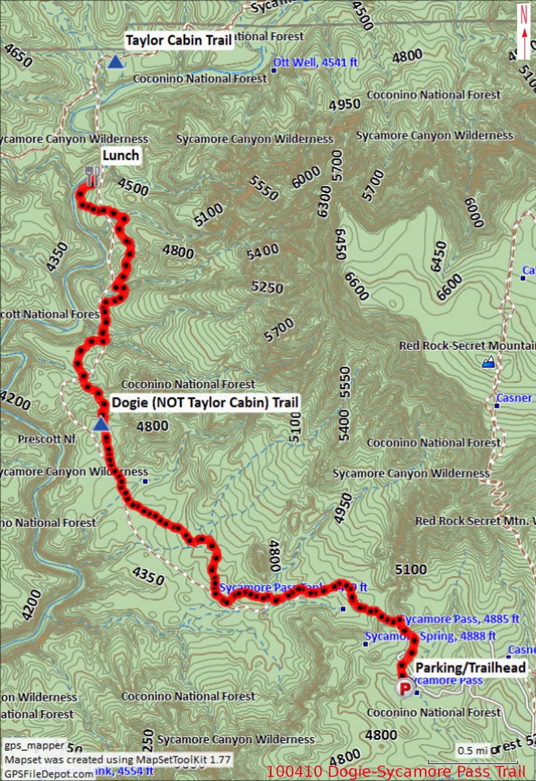
Editor's note: No one made a GPS track of this hike, a major shortcoming in my opinion, so I have used the track I made during the 2011 hike. The route at least approximates the route taken by the author of this report. The red track on the included map shows the route to the top of the mesa; the blue track shows the 2011 return route.

This report was written by Daisy Williams and assembled, edited and posted online by Ellis Price with help from Lila Wright.


1Price, E. F. (2012). Hiking in and around Verde Valley. United States: Createspace. P 327


Monday, February 13, 2017

Dogie Trail – Sycamore Pass


Parking at Sycamore Pass
Location: 34°55'21.08"N; 111°59'41.80"W
Elevation: 4681

Thirteen Skyliners (Donna Goodman, Betty Wolters, Daisy Williams, Anita Jackson, Dolly Yapp, Miriam Sterling, Marvin Alt, Gordon Bice, Fran Lind, Lila Walker, Ellis Price and two others) hiked on Dogie Trail in the Sycamore Canyon Wilderness on 10 April 2010. On 28 January 2017, Jim Manning led a second group of hikers (Karl Sink, Glenn Sperry, Jon Beach, Jim Manning, Chris Jensen, Jim Gibson, Dana Smith and Dave Beach). From Cottonwood, both groups took State Highway 89A to FR 525 just past mile marker 364. Then followed FR 525 for about 2.8 miles before turning left on FR 525C (Sycamore Pass Road) and continuing for about 9 miles to arrive at the Dogie Trailhead at Sycamore Pass.

Our hike leader for the 2010 hike, apparently still aggravated from our failure to remain closely grouped on a previous hike, lectured us severely about Skyliner Rules. Most importantly, we were told not to get ahead of the leader and to remain together so that she would know where everyone was at all times. She also said that we were supposed to be a social group and that we were to remain together and enjoy socializing as a group. Altogether, it reminded me of being chewed out by Chief Petty Officer Weir, my Company Commander during recruit training in 1951.

On the 2016 hike, one member, had a problem with his legs part-way into the hike and had to turn back; Dave Beach remained with him while the rest of the group continued on to Sycamore Creek. I had noted in 2010 that a couple of signs, with the trail name misspelled as “Doggie” instead of “Dogie,” were posted at the parking area and along the way to where the trail officially starts. No one mentioned the signs on this hike and I don't know whether they have been corrected. In any case hikers pass through a gate at the saddle about 200 yards from the parking area and enter the Sycamore Canyon Wilderness through a gate. Dogie Trail starts at this point.

After passing through the gate in April 2010 , I paused to take a couple of photographs looking ahead into the wilderness.

Looking into Sycamore Creek Wilderness from the saddle
Looking into Sycamore Creek wilderness from the saddle
On leaving the saddle the trail, at first, leads fairly steeply downhill. The following photograph shows the trail as it appeared in April 2010.

Heading down into the wilderness from the saddle on Dogie Trail  - 2010
For the current hike it was covered with ice, as shown in the below photograph, provided by Jim Manning.

Treacherous, ice-covered trail in February 2017
Probably the most distinctive rock formation along the trail is shown below. I thought it looked a bit like a giant coffee mug.

Rock formation resembling a giant coffee mug
We saw numerous flowers along the way in 2010.

Creamcups                                                    Dwarf mountain ragwort (?)
Purple milkvetch                                           Touristplant or Draba
Plains blackfoot/Blackfoot Daisy             Dock of some sort
Just under 1.75 miles from the parking lot we passed Sycamore Tank. The tank contained very little water in 2010. But, as we noted on the way back in on that hike, enough to attract a couple of migrating ducks. Sadly, my attempt to photograph the ducks resulted in nothing useful. However, Jim photographed the now-brimming tank, alas without ducks, during the current hike.

Sycamore Tank in January 2017
After traveling just over 5.5 miles from the parking lot we reached Sycamore Creek. From here the trail crosses the creek and continues upstream along the opposite side to connect with the Taylor Cabin Trail about one-half mile ahead. We stopped in 2010 and again in 2017 at the stream for lunch before turning back. In 2010, I ate rapidly, had a quick hot tea and settled in for a nap. I managed to find a nice spot several yards from the group and the quiet murmuring of the creek soon lulled me to sleep. I awakened about forty-five minutes later when the other hikers were up and ready to head back up the trail. I lingered a bit to take a photograph.

Looking up Sycamore Creek from the Dogie Trail Crossing in 2010
The hikers report that Sycamore Creek was running full, bank to bank, at the time of the 2017 hike.  Unfortunately, no one thought to take a photograph. 

The total hiking distance was 11.3 miles as shown by my GPS in 2010. This distance was recorded from the parking lot to Sycamore Creek and back. So far as I can determine, no GPS track was recorded for the current hike. The GPS profile for the hike shows a maximum elevation of 4881 feet and a minimum of 4194 feet. The elevation change on Dogie Trail between the parking area and Sycamore Creek is only 687 feet; however, the total in-and-out ascent, due to all the ridges and washes crossed along the way, was recorded as 2251 feet. It is not a difficult hike, but does require some stamina.

The map included as part of this report (below) shows the GPS track recorded in 2010 for this hike.

NOTE: On some maps, Dogie Trail is incorrectly listed as part of Taylor Cabin Trail.


Saturday, February 11, 2017

Adobe Jack Loop Hike


On Saturday, 7 January 2017, Dave Beach led twelve Skyliners on the Adobe Jack Loop. He drove us northeast on State Route 89A to the trailhead between West Sedona and Uptown Sedona. The trailhead is on the north side of the highway just 0.3 miles beyond Airport Road and just before the Mariposa Restaurant.

The morning sun was still lurking just below the eastern horizon when we arrived in Sedona, but had already announced its presence by the glorious colors reflected from the low-lying clouds.

Sunrise in Sedona
There are several trails, collectively designated (right) as "Soldier Wash Trails", in this area. Three major trails run in the north-south direction up the wash. These are Adobe Jack (to the west), Javelina (to the east) and Grand Central located between these two. Several shorter trails serve to connect these three together.

Another sign posted at the Adobe Jack Trailhead provides the following information about HJ Meany, the individual for whom the trail was named:

"HJ Meany, also known as Adobe Jack, was born in Prescott, Arizona to a couple of European ancestry who met at Castle Hot Springs not far from there. They worked on the Crown King Railroad, were gold miners in the Congress Mine, and moved to California during the Great Depression. Jack came from a working class family who struggled through rough times. He served in WW11, graduated from USC School of Engineering, and ultimately climbed the corporate ladder. He always kept his love for the Old West in his heart and soul. He is dearly missed by his family and all who knew him." This sign is signed by George and Claudine.

Although our schedule had named only the Adobe Jack Trail, Dave would take us on a loop hike that would include some or all of the following trails: Crusty, Grand Central, Javelina, Jordan, a short loop around Ant Hill and Adobe Jack itself.

We left the parking area on Adobe Jack, crossed a wash (left), a side branch of Soldier Wash, and immediately turned right onto Crusty Trail. A small stream running down the wash formed an attractive waterfall. After 0.4 miles we came to the end of Crusty at Grand Central Trail. There we turned right and continued for another 0.2 miles to arrive at Javelina, the trail we would follow on our journey up the wash. We hiked the entire 1.2 mile length of Javelina Trail, ending up at Jordan Trail. Along the way we passed the upper Power Line Plunge Trailhead at a junction with Javelina. From here Power Line Junction runs southwest, crosses Grand Junction and ends at Adobe Jack just 0.9 miles north of the trailhead on Hwy 89A.

Just over a 100 yards beyond Power Line Plunge, Javelina Trail ends at Jordan Trail. This Trail, new in 1999, serves as a connector to other trails in the area and would lead us northwest to the upper end of Adobe Jack at the Devil's Kitchen.

About 0.5 miles from the Javelina/Jordan Trails junction we came to Ant Hill Loop Trail (right), a short trail that loops around a large mound named Ant Hill. We used it along with a short section of Grand Central, which intersects Ant Hill Loop, to hike around and to the top of Ant Hill.

As we traveled along Jordan Trail, and especially from Ant Hill itself, we had great views of the red rock country all around and on to distant mountains beyond. The following photograph shows snow-covered Mingus Mountain beyond the shoulder of Ant Hill.

Snow-covered Mingus Mountain in the distance
Our hike leader, Dave Beach, gathered us all together for a group photograph on top of Ant Hill.

Left to right: Dave Beach, Roxanne Wessel, Chris Jensen, Connie Woolard, Roger Fenske, Daisy Williams, Joanne Hennings, Anita Jackson, Ellen McGinnis, Loren Pritzel, Jim McGinnis, and Jim Gibson
Shortly after returning to Jordan Trail, we arrived at Devil's Kitchen sinkhole. This is a natural sinkhole located at the convergence of Soldier Pass, Cibola Pass, Jordan and Adobe Jack Trails.

At Devil's Kitchen there are signs reminding us to use extreme caution when walking near the sinkhole. Sedona geologist, Paul Lindberg, writing for the Arizona Geological Survey1 notes that, “The Devils Kitchen sinkhole formed catastrophically and will continue to enlarge over geologic time”. He continues by saying, “Certain edges of the Devils Kitchen sinkhole are at greater risk of collapse while others are deemed less likely to collapse. It should be emphasized, however, that no degree of certainty exists at this site.”

A sign posted at the site provides diagrams and explanations detailing the sinkhole's creation along with pertinent measurements and dates. One wall of the sinkhole is shown in the photograph below.

Devils Kitchen Sinkhole
A short distance away from the sinkhole our return route on the Adobe Jack Trail began (left). In some spots the trail was muddy but not bad enough to cause mud to cake on our shoes.

We had a good view of the Fin (or Sail) and Steamboat Rock as we hiked along Adobe Jack Trail.

The Fin (or Sail) and Steamboat Rock
At about noon we found that we were more than half-way through our hike, so we decided to continue on without stopping for lunch. We had already eaten a snack while we were on Ant Hill.

On this first hike of the new year the sky was all gray and the weather was cold enough that most of us kept our warmest jackets on throughout the hike. The most significant wildlife we saw during the hike were two deer, a buck and a doe.

This hike was about 5.4 miles long and the elevation varied between 4385 feet and 4660 feet. Editor's note: These statistics are only estimates because no one provided a GPS track for the hike and some of the track data was hand-drawn by the editor.

The route to the Devil's Kitchen included a 100-yard section of Adobe Jack Trail, the entire 0.4 mile length of Crusty Trail, about 0.2 miles of Grand Central Trail, the entire 1.2 miles of Javelina Trail, about 1.6 miles of the Jordan Trail combined with a short, about 0.7-mile, loop trail to circle around Ant Hill and climb it for the view. The 2.0-mile return track, from Devil's Kitchen to the parking lot at Hwy 89A, was entirely by Adobe jack Trail. The included map (below) shows the entire hike in red.

Other trails shown within the loop we hiked include two segments of Grand Central (purple), Power Line Plunge (green) and Coyote (blue).

This report was written by Daisy Williams and assembled, edited and posted online by Ellis Price with help from Lila Wright.


1http://azgeology.azgs.az.gov/archived_issues/azgs.az.gov/arizona_geology/winter09/article_devilskitchen.html

Thursday, February 2, 2017

Hike to Old Still in Fay Canyon


Eleven Skyliners hiked to the site of an old still in Fay Canyon on 10 December 2016. This report, based on that hike, also uses information from Ellis Price's report of a 3 February 2010 hike published in his book, "Hiking in and Around Verde Valley"1. Two of today's hikers had also been on that earlier trip.

To travel to the old Fay Canyon still we actually followed Bear Mountain Trail for 0.6 miles from the Doe Mountain/Bear Mountain parking lot at the foot of Doe Mountain. We then turned north into Fay Canyon, following a sometimes tedious social trail located high on the canyon's west wall.

A more familiar, and easier, Fay Canyon hike is along Fay Canyon Trail, another hike described by Ellis Price in the same book.2 Unfortunately, two of the hikers who gathered in Cottonwood for today's hike thought it was to be a repeat of the hike on Fay Canyon Trail. Upon learning that it would instead involve climbing part way up the talus slope of Bear Mountain and then hiking along the canyon wall, they decided not to go with us.

From the Doe Mountain/Bear Mountain parking lot, we crossed the paved Boynton Pass Road and stepped over a green pipe crossbar at the trailhead. That pipe was almost too high for me, just a bit higher and I would have had to crawl under. The base of Bear Mountain was some distance away and in between, across a flat-looking area, there were several moderately deep gulches which we had to cross before we began the steep climb up Bear Mountain Trail to the social trail turnoff into Fay Canyon. This turnoff could be missed by the less observant hiker but the GPS co-ordinates for it are included in the 2010 report.3 Additionally, within the angle made by the two trails, there stands a tall rectanglar-shaped pillar of red rock, shown below, with a small, vertical slit forming a window near the top on the right side of the pillar.

Red rock with a small vertical window near top right
This hike is difficult to follow in a few places and it is best to use a GPS device. The trail follows a shelf or wide ledge high on the west wall of the canyon. At places the shelf is wide and covered with a mixture of grass, cactus, juniper and manzanita. Gradually, however, it tapered to become a narrow rock ledge. As we traveled north along the shelf we had a high cliff wall (below left) on one side and a sheer drop down into Fay Canyon on the other. After traveling for about half an hour after leaving Bear Mountain Trail, we could look across the canyon to the top of Fay Canyon Arch (below right) on the far side. From this angle the arch is indistinguishable from a shallow cave.

                                          Sheer canyon walls to the west                Fay Canyon Arch

It was time for our snack break and we paused at a spot with a panoramic view looking back through the mouth of Fay Canyon toward Dry Creek Road, Capitol Butte and Chimney Rock.
Snack break – with a view out the mouth of Fay Canyon
The goal for this hike was a smoke-stained overhang, containing discarded coffee cans, an old galvanized tub, and some barrel hoops. Sheltered from view from above by the overhang itself and from the canyon floor below by a rock ledge, it is rumored to have been the site of a still during the prohibition era. The two hikers, George Everman and Jim Manning, who had been to the location before reported that they had looked for, but never found, a way to access the spot from the bottom of Fay Canyon. Thus the route we took along the canyon wall, well above the floor.

About 1.2 miles from the Bear Mountain Trail turnoff we came to a shelf of bare rock, completely devoid of vegetation save for the occasional scraggly plant struggling for survival in a crack. The overhang which houses the old still site is located just under the lip of the bare rock ledge upon which we stood. At first the edge of the rock shelf appears to present a straight descent into the canyon far below. A closer look reveals a narrow ledge just below and a way to climb down to it. Without further ado, we shed our packs and started the descent. As I made my way down, I thought about the return trip. Would I be able to make it on my own or would I need a boost?

Once on the ledge, we traveled in the down-canyon direction for about 100 yards, making our way around a few stunted trees, several large boulders and some cactus plants before reaching the remains of the old still. This descent and the route along the narrow ledge are shown in the map insert (right).

Ellis Price is shown below in a photograph taken during the 2010 hike. Everything remains essentially the same as at that visit.


Ellis Price at the old still ruins – 3 February 2010
Assuming the tales of moonshiners are true. we wondered how they might have brought in their raw materials and hauled out the finished product. It is a fairly tough route the way we came. They could, however, have used pack animals.

Along the ledge we found a variety of plants growing in patches (below left) where moisture seeps from the cliff. There were also numerous rocks of various sizes and shapes all piled together where they have fallen from the overhang (below right).


Plants growing in a seep Rocks fallen from overhang
Two hikers ventured even further along the ledge, beyond the overhang, until it became too narrow for safety.

Gary Jacobson and Dave Manning -on the narrow part of the ledge

The two photographs below, taken as we headed back to where we had descended to the ledge, show a downstream section of the cliff wall stained with dark mineral deposits from water running over the edge (below left) and an upstream view into the depths of the canyon (below right).

A view down the canyon A view up the canyon

Back on the rock shelf above the overhang, we stopped to eat lunch near an area of water-retaining depressions separated by weirdly-shaped rock surfaces (left). I wondered: Could the strange shapes of the rock between the depressions represent sand blown by wind and moved by waves in an ancient tidal zone?

The trail back led us along a narrow ledge at the head of a side canyon and there we were faced with a cliff wall adorned with bright yellow lichen (below left). Atop the cliff a small manzanita (below right) lifted its reddish brown branches, topped by dark green leaves, to the sky, struggling to survive in a sparse patch of soil.

Bright yellow lichen on the cliff wall A manzanita growing atop the cliff
Back at Bear Mountain Trail, we paused for a group photo before heading back down the mountain and across the gulches.

Left to right: George Everman, Karl Sink, Jim Manning, Joanne Hennings, Joyce Arregui with Dave Beach (standing), Lila Wright, Daisy Williams, Dave Manning, Betty Wolters, and Gary Jacobson.
This hike was 3.9 miles long, the highest elevation was 5137 feet and the total ascent was 1188 feet.

The GPS track for this hike is shown in red on the included map (below). For the sake of clarity, only the return route is shown. The hike in included a bit of exploring and was slightly longer.

This report was written by Daisy Williams and assembled, edited and posted online by Ellis Price with help from Lila Wright.


1Price, Ellis F. Hiking in and Around Verde Valley. USA: CreateSpace, n.d. Print. pp 43-50
2Ibid, pp 27-36

3Ibid, p 44