Fourteen
hikers turned out for our 17 January 2015 hike, not as many as last
Saturday when we were 18 strong, but more than usual. We normally
number somewhere between 7 and 10 and have never had a turnout of
more than 21 or 22. We are an informal group with no dues and little
in the way of rules. We don't allow dogs because they are just too
much trouble on the trail when hiking in groups. Other than that, we
just obey such standard rules as avoiding losing contact with the
group. This is primarily done by asking each hiker to be aware of
the location of the next hiker in line.
For
this hike to Rosie's Volcano, an area with a lot of social trails and
not one official trail, we would use a tailgater, a hiker who brings
up the rear to make sure no one wanders off the trail taken by the
main group. Dave Beach and George Everman alternated in performing
this task.
I
was unable to find any specific information on this volcanic cone
but, located about a mile to the north, slightly northeast of the Dry
Creek Bridge on Hwy 89A, it is easy. Finding the start of the trail
leading to its top is another matter. One continues for another 0.8
miles after crossing Dry Creek Bridge and turns left on the road that
runs between Sedona Pines Resort and Sedona Shadows 55+ manufactured
home community. The name of the road is Red Moon Drive; however, I
don't know that the name is posted in an obvious location. Less than
0.1 mile from the highway one must turn left onto

 Sunset
Hills Drive, continue for about 0.4 miles and turn right onto Pine
Drive, not obviously marked, at the sign (right).
Sunset Hills Drive itself turns slightly left and continues across
Dry Creek. Once on Pine Drive you must immediately turn left onto
Loop Drive (left). After turning onto
Loop Drive continue for 0.1 mile to a small parking and rest area
located on the left side of the street. There is room for four
vehicles if you squeeze them in tightly. The rest area is clean and
orderly like everything else in this well-maintained community.
Sunset
Hills Drive, continue for about 0.4 miles and turn right onto Pine
Drive, not obviously marked, at the sign (right).
Sunset Hills Drive itself turns slightly left and continues across
Dry Creek. Once on Pine Drive you must immediately turn left onto
Loop Drive (left). After turning onto
Loop Drive continue for 0.1 mile to a small parking and rest area
located on the left side of the street. There is room for four
vehicles if you squeeze them in tightly. The rest area is clean and
orderly like everything else in this well-maintained community.
While
we were disembarking and donning our backpacks, a voice greeted us
saying, “Have a nice hike.” After some searching we found that
the voice belonged to a lady hidden in the shadows on a porch across
the street. She then crossed the street carrying a hat that she
thought one of the hikers might be able to use. Apparently she was
in the process of moving and didn't need it anymore. It was a nice
gesture, but we had all brought adequate headgear with us, so we
politely declined. Whereupon she hung her hat on a post and left.
 A
dyke, with a concrete block wall on its top, has been erected along
the bank of Dry Creek to protect the community from floodwaters. We
needed to cross Dry Creek to reach the volcano so we climbed the
provided cross-tie steps (right)
to check for a way to the other side.
A
dyke, with a concrete block wall on its top, has been erected along
the bank of Dry Creek to protect the community from floodwaters. We
needed to cross Dry Creek to reach the volcano so we climbed the
provided cross-tie steps (right)
to check for a way to the other side. Atop
the dyke, we found a nice walking path, apparently running the entire
length of the structure. The concrete block wall served to prevent
walkers from falling down the steep bank on the other side and also,
I suppose, as an additional protection against flooding. It was
immediately obvious that we couldn't safely descend into the wash
there, so we turned downstream toward the Sunset Hills crossing where
we knew we would be able to descend into Dry Creek Wash. Along the
way we could look down onto the neatly-tended back yards (left).
Atop
the dyke, we found a nice walking path, apparently running the entire
length of the structure. The concrete block wall served to prevent
walkers from falling down the steep bank on the other side and also,
I suppose, as an additional protection against flooding. It was
immediately obvious that we couldn't safely descend into the wash
there, so we turned downstream toward the Sunset Hills crossing where
we knew we would be able to descend into Dry Creek Wash. Along the
way we could look down onto the neatly-tended back yards (left).
Looking
ahead we could see the end of the dyke and a well-worn path leading
back up the wash on the other side of the wall.
 |
Walking path and concrete block wall atop the dyke
|
 Just
before we turned to descend into the wash we found a very healthy
looking prickly pear cactus with odd-shaped leaves (right).
Daisy told me it was a variety called cow's tongue or
mother-in-law's tongue.
Just
before we turned to descend into the wash we found a very healthy
looking prickly pear cactus with odd-shaped leaves (right).
Daisy told me it was a variety called cow's tongue or
mother-in-law's tongue.
When
we had descended into the wash and were headed back upstream, we
found a well-worn trail along the wall of the dyke. Along this
section of the hike we met a lone hiker out walking two dogs. The
hiker gave us a cheery greeting and his dogs were friendly, but each
found something to bark at, reminding us again why dogs are not a
good idea with large groups.
We
had two goals in mind for this hike. The first and primary one was
of course to climb to the top of the old volcano. A secondary goal
was to visit the small, red butte above the El Rojo Grande Ranch,
sometimes known as Wrigley Ranch. We could now see both at a
distance . The volcano as viewed from the dyke is shown below.
 |
Rosie's Volcano seen from the dyke along Dry Creek Wash
|

Looking
directly up the wash we could see the red butte marking the El Rojo
Grande Ranch (left).
The
trail we were following led us on past the area where we had parked
and then turned and crossed the wash. Although hardly enough to wet
our feet if we tried, we did find water in Dry Creek.
The
trail, after crossing the creek, was still well-defined, showing
fairly heavy usage by both hikers and equestrians. I did, however,
take the wrong fork at one point and did not notice my error until it
became obvious that we were deviating widely from a GPS track I had
made six years ago. We corrected course and continued toward the
saddle just to the right of the volcano (photograph
above), judging that the climb from there would
be less precipitous than elsewhere. At least part of the way we
found that we were following along the track of an ancient wagon
road.
Dave
Beach, an avid bird watcher, had brought his binoculars and a birding
book along to see how many birds he could identify. For the climb
from the saddle, to avoid having the main party of hikers scare the
birds away before he got a chance to see them, he went on ahead with
one other hiker. The rest of us brought up the rear, pausing at each
fork in the trail to let the slower hikers catch up and make sure we
all kept to the same trail
After
a stiff climb we all arrived at the top and settled in to enjoy the
view while having an early lunch.
 |
| Left to right: Miriam Sterling, Pat McCue, Joanne Hennings, Dave Beach, Daisy Williams, John Ashworth, George Everman, Jill Ashworth, Anita Jackson, Lila Wright, Connie Woolard, Dolly Yapp and Karl Sink – photograph by the author |
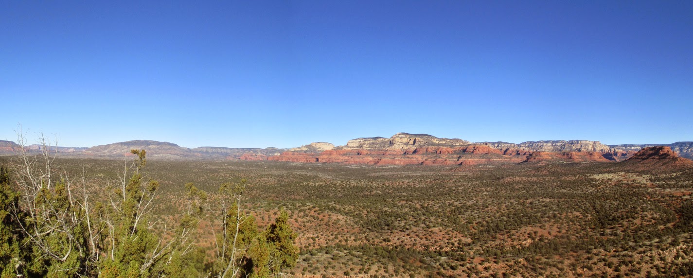
The
below photograph shows the view from Mingus Mountain southwest of us
to Black Mountain in the northwest. The mountain in the near
distance with the pipeline scar running along its shoulder is,
according to Google Earth, Windmill Mountain. Just a bit of Sycamore
Gap is visible at the far right.
 |
Mingus Mountain to Sycamore Gap as seen from atop Rosie's Volcano
|
Below
is the view of red rock country from Sycamore Gap (just a sliver of
Black Mountain shows at the extreme left) in the northwest to
Cockscomb slightly northeast of our viewpoint. Lined up along the
way, left to right are: Casner Mountain, Loy Butte, Bear Mountain and
Doe Mountain (the flat-topped mesa just to the left of Cockscomb).
 |
Sycamore Pass to Cockscomb from atop Rosie's Volcano
|
After lunch we headed
back down the trail. Several of the faster hikers went on ahead with
the agreement that they would wait for us on the saddle. We would be
leaving the trail we had hiked in on just below the saddle so as to
visit the small butte at El Rojo Grande Ranch. On a previous hike to
the butte, we had come out between the butte itself and the red rock
outcroppings behind it. But that was a pretty strenuous hike that so
far as I could see yielded no advantage over hiking along a fairly
distinct trail that would allow us to come out on top of the
outcroppings. After all we certainly had no intention of actually
climbing the butte and the top of the outcroppings looked to be
easily accessible. So it was that we struck out cross country to
connect with the trail that would take us there.
Although
we probably expended some unnecessary effort by bushwhacking instead
of just continuing along the trail we were on until it intersected
with the one we wanted, we did find the trail and followed it to a
saddle behind the outcroppings. The trail continued through the
saddle and probably ended down below at the El Rojo Grande Ranch, but
we turned off at the crest and had a fairly easy climb on up to the
top. We could now look across a narrow, separating saddle to the
red, cylindrical butte and also directly down onto the ranch
headquarters buildings.
According
to a July 2007 article in the Phoenix Business Journal1,
the 173-acre ranch is no longer owned by the Wrigley family
but was sold due to a divorce. The article goes on to say that
before selling the property one of
the Wrigley heirs built a 6,700 square foot circular house there in
1994. The modern-looking stables were probably also constructed
then. Sometime after that, the ranch was sold to members of the Hills
Brothers Coffee family and was again listed for sale, in 2007, for
$29,000,000. The article called it the El Rojo Grande Ranch while
Google Earth labels it Dos Leos Ranch but also includes the name El
Rojo Grande Ranch on the road leading to it.
We returned using the
same trail we ascended on, but continued on past the point where we
had joined it before. It led us into a saddle between the butte and
a smaller outcropping just below. From that saddle we had our best
view of the ranch. We could see very little of the house, located
just right of center directly below Scheurman Mountain in the
photograph below. Just to the left of the main house is what appears
to be the caretakers house and just below that is a large
green-roofed building, probably a barn. To the right of that, hidden
by the trees, are two additional structures, matching the large
building in style, that we presumed to be stables. Below and to the
left of what I have called a barn can be seen a green meadow with a
cluster of sheltered picnic tables located at its edge. Although the
ranch is obviously set up as an equestrian facility we saw nothing to
indicate that horses are presently stabled there.
 |
El Rojo Grande Ranch
|
In summary, this
appears to be a meticulously well-maintained “horseless” ranch
that could be called Wrigley Ranch, Hills Brothers Ranch, El Rojo
Grande Ranch or possible even Dos Leos Ranch.
We next turned our
attention to the slender red butte. I had hoped that someone would
be able to provide a name for it, but even Lila who has spent most of
her life in the area didn't know. It has a very distinctive nose
when viewed from the southwest, so we decided to just call it “Who
Nose” Butte.
 |
Who Nose Butte at El Rojo Grande Ranch
|
We
followed the trail we were on down the spine of the hill until we
intersected with Dry Creek Wash at the upper end of the dyke. We
then continued down the wash to the lower end and exited where we had
entered. As can be seen by the messy looking track at the bottom of
the included map (next page), we
returned to the parking area by way of Loop Drive rather than along
the top of the dyke.
The
red line is our GPS for this hike. The short blue line to the left
of Who Nose Butte shows a path to take that should avoid bushwhacking
altogether.
This
hike was 4.0 miles total. The highest elevation was 4654 feet and
the total ascent was 1126 feet.

1http://www.bizjournals.com/phoenix/stories/2007/07/16/daily8.html
Want to do this hike, missed the one today. Been wondering how to get closer to the "who nose butte". Thanks for the great article!
ReplyDeleteI’ve wanted to hike this since I was a little girl. Thanks for the insight for when I finally do it!
ReplyDelete