Seven
Skyliners (Lila Wright, Dolly Yapp, Kwi Johnson, Donna Davis, Miriam
Sterling, Anita Jackson and the author) hiked on Mt. Elden on 15
September 2012. We drove to Flagstaff, took US
180 W and followed it about 3.2 miles before turning right on Schultz
Pass Road. We followed Schultz Pass Road for about 0.5 miles before
taking FR 557 (Elden Lookout Road) by continuing straight ahead where
Schultz Pass Road turns sharply left. The first part of this road is
paved; however, the pavement soon ends. The dirt road was in very
good condition and we did not really need the high-clearance vehicles
we were traveling in. We drove about 2.9 miles on Elden Lookout Road
to reach the Brookbank Trailhead, where we found parking for three or
four cars. Only one car was there, so we had room to park our two
vehicles.
None
of the maps I looked at before starting this hike were really up to
date. The Arizona topographic map I use in my GPS shows old, no
longer existing roads, and calls Brookbank Trail along with a section
of Sunset Trail “Oldham to Sunset Trailhead.” The trail map
available on the Hiking Section of the Coconino National Forest
website doesn't show Little Bear Trail on the page that highlights
Brookbank Trail. Finally, Google Earth with the National Geographic
Topographic overlay does not show the trails in this area.
Notwithstanding
the map confusion, Lila had hiked this way before and we set out up
Brookbank Trail with confidence.
 |
Hikers heading up Brookbank Trail just above Eldon Lookout Road
|
 Just
one mile from the trailhead (my GPS said 1.2 but was incorrect), we
came to a fork in the road. A posted sign (right) indicated that Brookbank
turned to the right and that straight ahead was Schultz Loop Trail
(not shown on any of the maps I referenced).
Just
one mile from the trailhead (my GPS said 1.2 but was incorrect), we
came to a fork in the road. A posted sign (right) indicated that Brookbank
turned to the right and that straight ahead was Schultz Loop Trail
(not shown on any of the maps I referenced).
We
decided to deviate from Brookbank Trail for a walk across an
expansive meadow that Lila told us was straight ahead and a snack
break at a good viewpoint, so we followed Schultz Loop. We would
return later to this intersection and resume our loop hike.
Just
one-tenth of a mile from the intersection we came to the edge of the
meadow. Schultz Loop Trail continued alongside the meadow, but we
turned west on a social trail that headed straight across it. As we
were approaching the other side of the meadow, which appeared to be
formed from an ancient lake bed, we turned to the southwest on
another social trail that followed the course of an old road (still
shown on my topo map).
Most
of the flowers in the meadow appeared to have already passed their
peak; however there were still a few hardy clumps of sunflowers, some
Indian Paintbrush and several gorgeous butter and eggs flowers
scattered along the way. Additionally, we saw a few salsify or
salsifi (Tragopogon) flowers. Salsify, also known as
goatsbeard, is a native of Europe and Asia1.

Nine-tenths
of a mile from Schultz Loop, we came to the viewpoint that was our
goal for a snack break. We found there a nice rocky outcrop with a
great view out over Flagstaff and beyond. Lila is shown here (left) climbing up to find a comfortable perch, while
Dolly is approaching from below.
I
also climbed the rocks and found that we did indeed have a good view.
We could see the city of Flagstaff laid out below us, Mormon
Mountain directly beyond the city and Flagstaff's Buffalo Park closer
in. Meanwhile the slope of Mount Eldon loomed to our left. These
are all shown in the photograph below.
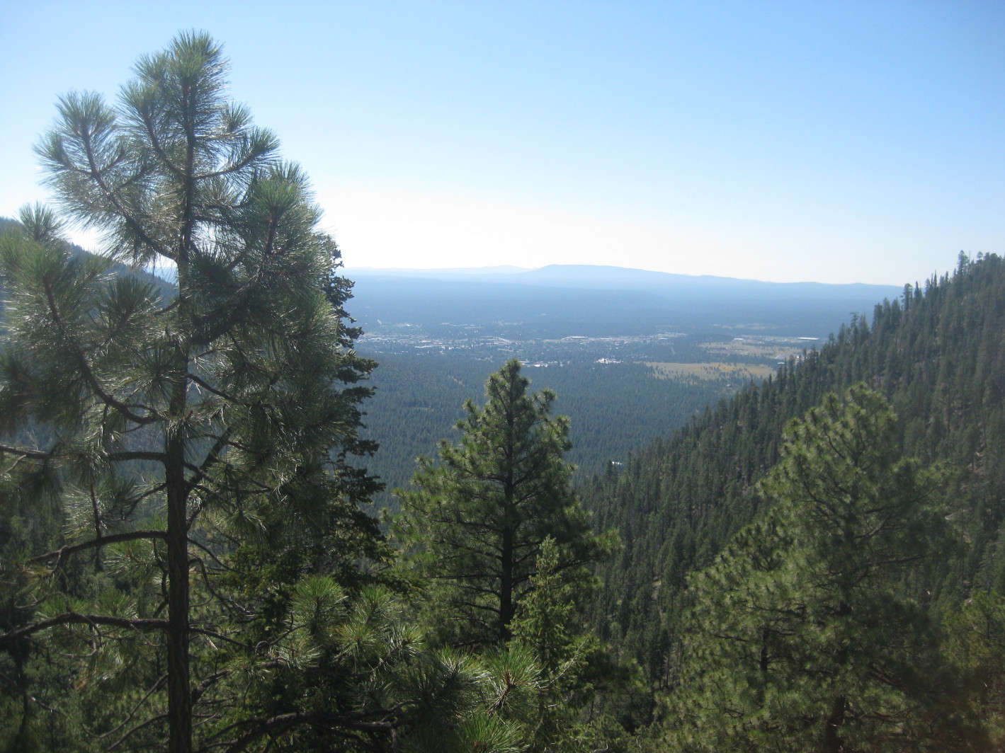 |
The shoulder of Mount Eldon is seen through the tree branches to the left,
Flagstaff is in the center with Mormon Mountain beyond and Buffalo
can be seen at center right (the lower treeless area)
|
 From
the viewpoint we retraced our way back to the Schultz Tank/Brookbank
junction and resumed our loop hike by continuing on Brookbank. The
trail lead us around a small peak (8747 feet high) located in the
middle of the Dry Lake Hills. As we rounded the north side of this
small peak we could look straight across Schultz Pass to Doyle Peak
(right) on the horizon.
From
the viewpoint we retraced our way back to the Schultz Tank/Brookbank
junction and resumed our loop hike by continuing on Brookbank. The
trail lead us around a small peak (8747 feet high) located in the
middle of the Dry Lake Hills. As we rounded the north side of this
small peak we could look straight across Schultz Pass to Doyle Peak
(right) on the horizon.
Shifting our view a bit to the left (northwest) we had a glimpse
through the trees of Fremont and, peering over its shoulder, the
treeless upper portion of Agassiz.
 |
Fremont (center) with Agassiz peering over its shoulder (behind the trees)
|
By
my GPS it was 2.1 miles from the Junction of Brookbank and Schultz
Loop trails to the end of Brookbank at Sunset Trail. If accurate,
that would mean that Brookbank is 3.2 miles long as opposed to the
2.5 miles provided by the forest service signs.
When
we arrived at the end of Brookbank, we found ourselves in a less than
ideal spot for lunch and, although it was now noon, decided to
continue on to eat at the start of the social trail that we intended
to take back to Eldon Lookout Road. That turned out to be just 0.3
miles ahead and was an ideal lunch spot. We were now in a grassy
meadow with a choice of sun or shade and a gentle, refreshing breeze
was blowing.
After
lunch, we walked about 100 yards east along Sunset Trail beyond the
Little Bear turnoff and then turned right (southwest) on a social
trail to head down the mountain and reconnect with Eldon Lookout Road
1.2 miles above where we were parked.
A
quick calculation indicates that we would have added less than a mile
to our hike had we continued on Sunset Trail to Upper Oldham Trail
(not shown on any of the maps I am using). We could have returned to
our cars this way without hiking on the road at all. I thought the
route we took was quite acceptable; however, I would like to do the
loop we did today, leaving off the side trip up Schultz Loop Trail
and through the meadow to visit the viewpoint and adding the return
by way of Upper Oldham. Upper Oldham, by the way, is a name I saw on
a trailhead sign where the trail intersected with Eldon Lookout Road.
According
to my GPS this hike was his hike was 7.2 miles long, the maximum
elevation was 8666 feet and the total ascent was 1795 feet.
The
GPS track for this hike is shown on the included map (below).

1http://en.wikipedia.org/wiki/Salsify
No comments:
Post a Comment