On
6 February 2016, the Skyliners hiked Kel Fox Trail. We had
previously hiked the trail on New Years Day in 2011. I wrote a
report for that hike, so I will simply add a few additional comments
here and republish that 2011 report,.
The
first comment concerns the start of the hike. In the original report
I provided directions to the paved parking area and described the
start of the trail. I have now added a photograph showing the gate
(see red arrow, below) intended for
hiker use. Apparently, hikers are supposed to use this gate, to exit
to the road right of way along CR 78 (Beaverhead Flat Road), follow a
non-existing trail for about 100 yards to the intersection with Old
Beaverhead Flat Road (a dirt road) and then recross the fence through
a similar gate located adjacent to a cattleguard in the dirt road.
However, it is much easier to just pass along the left side of the
gate, follow along the inside of the fence and access the dirt road
just beyond the cattleguard.
 |
Hiker gate leaving parking area
|
On
the return hike we saw a large, isolated boulder, lying in the center
of a clear, grassy area. The boulder seemed somehow out of place,
lying there in splendid isolation. This was the fourth time I had
passed this way, the last time just a couple of hours earlier, but
the first time I had taken note of the boulder. It is located in the
saddle above Fuller Tank about 1.1 miles from the trailhead on
Arabian Road and some 85 yards west of the trail. It was now almost
noon and this area afforded us clear views north into the Red Rock
Country and south all the way to the distant mountains in Tonto
National Forest, so we decided to stop for lunch.
On
approaching the boulder, we found that it contained Indian
petroglyphs, some sort of abstract (at least to me) design along with
a picture of an animal (see red arrow, below)
such as might have been made by a small child. The abstract carving,
composed primarily of neat, straight lines was rather appealing. On
the other hand the Indian who drew the animal needed a few more art
lessons.
 |
Isolated boulder with Indian drawings
|
On
the 2011 hike we had stopped for lunch just 160 yards from our
present location and had then turned back without continuing to the
Arabian Road trailhead. This time, we hiked the entire length of Kel
Fox Trail . For this reason, as well as to show the location of the
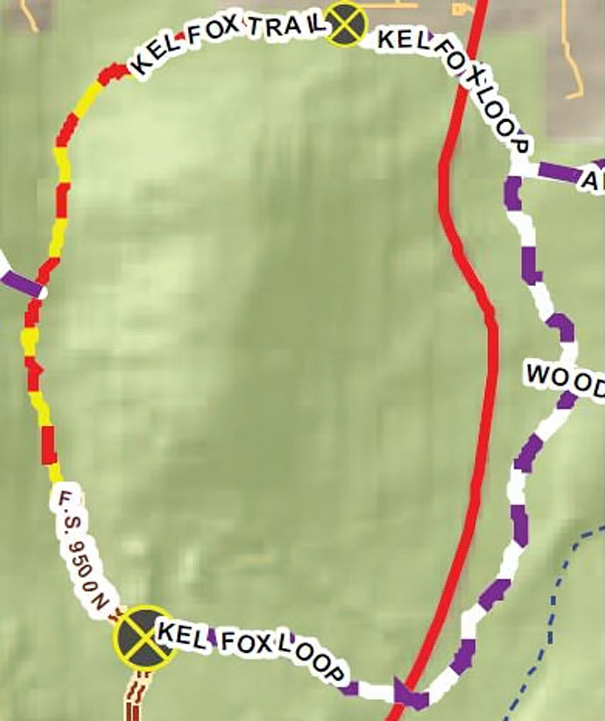
petroglyphs, I have included a revised trail map.
The
actual one way trail distance, starting where we parked off
Beaverhead Flat Road and ending at Arabian Road in the Village of Oak
Creek, is 3.5 miles. Our round trip hike distance, including the
detour to the petroglyphs and another small detour, was 7.2 miles,
the maximum elevation was 4277 feet and the total ascent was 1285
feet.
Our
GPS track, including the detour to the petroglyphs, is shown in red
on the below map.

NOTE: Starting below, the entire 2011 hike report is appended to this update.
Kel Fox Trail
To start the New Year
off right, eight Skyliners hiked on Kel Fox trail on New Year’s
Day, 2011.
I
was asked to include in the hike report some information about the
rancher for whom the trail was named. With a little research, I
unearthed SCR1012
- 441R, Kel Fox; death resolution1,
a concurrent resolution of the Arizona Legislature:
The Honorable Kel
Fox passed away on May 15, 1998, at the age of eighty-five.
Born in Stamford,
Connecticut in 1912, Kel Fox moved with his family to Arizona in 1922
where his family established the Foxboro Summer Camp near Sedona. As
a rancher and farmer, he served as president of both the Yavapai and
Coconino Cattle Growers Associations and was active in the Arizona
Cattle Growers Association and the Arizona Game Protective League. He
also was active in the Sedona Chamber of Commerce and the San
Francisco Press Club.
Known as a gentleman
and a scholar, Kel Fox graduated cum laude from Princeton with a
baccalaureate degree in history in 1935. He later attended the
University of Arizona where he received a doctorate degree in
agricultural sciences. During World War II, he ably served his
country in the United States Coast Guard.
In 1939, Kel Fox
embarked on more than fifty years of public service to the State of
Arizona through his efforts as executive secretary for Governor R.T.
Jones. He was subsequently elected to both the Arizona House of
Representatives and the Arizona Senate, serving from 1946 to 1954. As
a legislator, Kel Fox was a main force behind the construction of
Interstate 17 and providing rural counties with electricity. In
addition to his outstanding legislative service, Kel Fox also served
the state as a member of numerous commissions and boards, including
Water Quality Control, the State Board of Appeals, and Watershed
Management.
Kel Fox will be
sorely missed by his family, many friends and the citizens of the
State of Arizona. Therefore.
Be it resolved by
the Senate of the State of Arizona, the House of Representatives
concurring.
From
Cottonwood, we traveled north on Hwy 89A, took Cornville Road through
Cornville and, just after passing milepost eight, turned left on
Beaverhead Flat Road (sometimes labeled Beaver Flats Road).
We
continued on Beaverhead Flat Road about five miles before turning
left to park in a paved lot just a few yards from the road. We
paused here to take a group photograph before starting our hike.
 |
| Left to right: Daisy Williams, Lila Wright, Betty Wolters, Donna Goodman, Jim Manning, Gordon Bice – the author and one other hiker are not shown |
 A
clearly visible trail leads east from the parking area passing,
several yards ahead, between two plaques, one on either side of the
trail. The plaque mounted on the left side of the trail (see
right), describes the Chavez Trail running from
Prescott to Winslow. The Sunset Crossing mentioned in the plaque was
near present day Winslow. As a matter of fact, until just a couple
of years ago, the overpass (west of Winslow) that carries Interstate
Highway I-40 over the Burlington Northern Santa Fe (BNSF) Railway had
a sign that identified that spot as Sunset Crossing.
A
clearly visible trail leads east from the parking area passing,
several yards ahead, between two plaques, one on either side of the
trail. The plaque mounted on the left side of the trail (see
right), describes the Chavez Trail running from
Prescott to Winslow. The Sunset Crossing mentioned in the plaque was
near present day Winslow. As a matter of fact, until just a couple
of years ago, the overpass (west of Winslow) that carries Interstate
Highway I-40 over the Burlington Northern Santa Fe (BNSF) Railway had
a sign that identified that spot as Sunset Crossing.
I
assume this plaque, mounted on the right side of the trail (see
left),
is intended to credit those listed thereon with providing the parking
area. Information available on the website of a local inn2
indicates that the section of trail starting here and following a
natural gas pipeline east to the bottom of the hill where the
pipeline then turns north is Beaverhead Flat Trail. However, the
Verde Valley Regional Trails Plan (VVRTP)3
doesn’t show Beaverhead Flat Trail extending that far to the east.
Trail
names aside, soon after passing between the two plaques we arrived at
a fence fitted with a pedestrian gate. However, instead of passing
through the gate we continued on by and traveled more or less
parallel to the fence for about 100 yards to come out on a dirt road
running parallel to Beaverhead Flat Road and the gas pipeline.
(NOTE: One can access this road by vehicle just a few yards from
where we turned off to park, approximately at milepost 5.2.)
Counting from the parking lot, we followed this road for about
three-quarters of a mile to a fork in the road. The natural gas
pipeline ran along the road to our left and we went that way,
continuing for another seven-tenths of a mile to the end of the road
at Fuller Tank. This road is marked as FR 9500N, identified by the
same local inn website quoted previously, and is so labeled on the
Verde Valley Regional Tails Plan. An article in Sedona Monthly4,
on the other hand, identifies the road as FR 9501L all the way from
Beaverhead Flat Road to Fuller Tank.
Whatever
the official road designation, it is an easy hike and can be driven
in any high-clearance vehicle all the way to Fuller Tank. As a
matter of fact, most descriptions of Kel Fox Trail that I have seen
are based on driving to the tank to start the hike.
 The
presently existing Kel Fox Trail (see right),
as shown by the Verde Valley Regional Trails Plan runs from Fuller
Tank to Arabian Road in the Village of Oak Creek. The VVRTP also
shows a proposed Kel Fox loop that would cross and run parallel to
and east of Hwy 179, connecting the trailhead at Fuller Tank to the
trailhead at Arabian Road in the Village of Oak Creek.
The
presently existing Kel Fox Trail (see right),
as shown by the Verde Valley Regional Trails Plan runs from Fuller
Tank to Arabian Road in the Village of Oak Creek. The VVRTP also
shows a proposed Kel Fox loop that would cross and run parallel to
and east of Hwy 179, connecting the trailhead at Fuller Tank to the
trailhead at Arabian Road in the Village of Oak Creek.
Looking
ahead from FR 9500N as we approached Fuller Tank, we could see
outcroppings of red in a rock-capped mountain straight ahead of us.
Fuller Tank is located to the left of this mountain that forms one
side of the saddle that contains it.
 |
Looking ahead from FR 9500N. Kel Fox Trail starts at Fuller Tank, located in a saddle to the left of the mountain shown here.
|
FR
9500N ends at the dike creating the tank and Kel Fox trail starts
there. To access the trail from the road one has only to walk across
the dike and follow the pipeline markers along the hillside toward
the crest of the saddle. It is tempting to continue along the east
side of the tank from the end of the road rather than crossing over,
as there is a well trodden cow path there; however, as we could see
while hiking up the other side of the draw, it eventually fades away
and would have left us to bushwhack on up to the crest.
Before
leaving the area, we paused for a short break at the tank to catch
our breath, look around at our surroundings, look back at the way we
had come and look ahead at where we would go. The tank was nearly
dry at the time of this visit. We had expected that it would be
brimming with water after the recent rains, and we could only
surmise that it is no longer maintained and thus does not hold the
runoff. At least it does still serve as a miniature wetland,
retaining at least some moisture.
Following
are a few photographs of the area and a shot of the view behind us.
 |
| Jim Manning shown on the dike at Fuller Tank. Kel Fox Trail leaves the end of the dike beyond Jim and follows the pipeline along the slope to the right. |
 |
Looking down into Fuller Tank from the dike. At least a small wet area remains.
|
 |
Looking back the way we came from the dike at Fuller Tank
|
Continuing
on for about eight-tenths of a mile, we approached the saddle crest.
 |
Looking out over the Village of Oak Creek to the snow-capped red mountains in the distance
|
Leaving
the trail we climbed a short distance up the west flank of the
saddle to find a sunny lunch spot with a good view:
 |
| Looking across Oak Creek Village to the snow-capped red rocks beyond. Cathedral Rock is visible in the upper left section |
 |
| The Village of Oak Creek, Courthouse Butte and Snow-capped red rocks beyond |
Kel
Fox Trail is only about one and eight-tenths miles long and from
where we stopped it was still a mile to the trailhead on Arabian
Road in the Village of Oak Creek. However, including our hike up FR
9500N to reach the start of the trail, we had already almost two and
one-half miles to reach the spot where we ate lunch, and we decided
to turn around there and make an easy day of it. After all it was
New Years Day and we didn’t want to start the new year by tiring
ourselves out.
According
to my GPS track, this hike was five and four-tenths miles round trip
and the elevation change (highest to lowest) was around 635 feet.
To
access the trail from the Village of Oak Creek, turn off Hwy 179
onto Rojo Road, go about two-tenths of a mile to a fork and turn
left. According to the map I consulted, you will still be on Rojo
Road. Continue for just over 200 yards and turn right on Arabian
Road. You should find the trailhead on the left just over 100 yards
ahead.
On
the below map, I have
shown our hike in red and sketched in
the part of Kel Fox Trial that we did not hike in green.

No comments:
Post a Comment