A
bright morning sun highlighted the remaining patches of snow on
Mingus Mountain when we gathered in the Cottonwood Safeway parking
lot on 13 February 2016 for our scheduled hike.
We
planned to start and end our hike at the junction of Verde Valley
School Road and Turkey Creek Road (Forest Road 216B). Note that some
maps may show Verde Valley School Road ending at the turnoff to Verde
Valley School, 3.1 miles from Hwy 179, and call the rest of the road
Red Rock Crossing Road. In any case, it is 4.1 miles from Hwy 179 to
FR 216, so just stay on the main road. Our chosen parking area was
still 0.5 miles from Turkey Creek Trailhead, perhaps a more logical
place to start the hike, but we were unsure of the condition of FR
216B and the hike would anyway be fairly short.
We
donned our packs, set out at what was for us a brisk pace and were
soon at the Turkey Creek Trailhead. A relatively new sign (below
left) pointed us into the parking
area and a much older sign (below
right) pointed out the start of
Turkey Creek Trail.
 |
| Sign pointing to parking |
 |
| Old metal trailhead sign |
We intended to repeat a hike that some of the party had done in February
of 2009. From the trailhead we hiked south for 0.4 miles on Turkey
Creek Trail before turning southeast onto a well-traveled social
trail. Our hike leader in 2009 had told us it was Twin Peaks Trail.
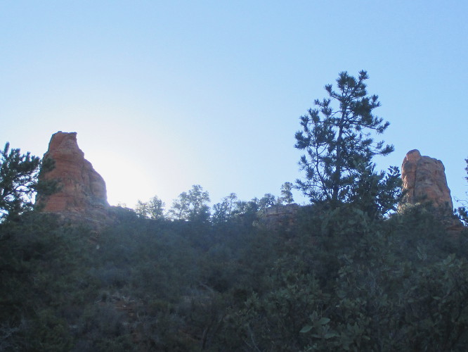
I have since learned that some maps show it as Twin Pillars Trail.
As we continued along the trail we could see, looking southwest, two
prominent peaks (below left)
that could have given the trail the name Twin Peaks. On the other
hand, looking straight ahead, silhouetted against the morning sun, we
could see two buttes (below right)
that could be called pillars protruding above the ridgeline. These
formations could easily have resulted in the name Twin Pillars.
 |
| Twin peaks |
 |
| Twin pillars |
Because,
in addition to these formations, we also visited Turkey Trail
Sinkhole on this hike I decided to title it the Twin Pillars, Twin
Peaks & Turkey Creek Sinkhole
hike, covering all bases so to speak.
About
0.4 miles from where we had turned from Turkey Creek Trail, we came
to a fork in the trail we took the left fork and continued for
another 0.3 miles, coming out at a saddle (below
left) overlooking Verde Valley
School on the other side of the ridge. The twin pillars shown above
were to right of the saddle and the left was marked by a rocky mound
(below right),
rising another 200 feet above the saddle.
 |
| Saddle as we approached |
 |
| North side of saddle |
We
had a great view to the north from the saddle at Twin Pillars. In
the below photograph, Capitol Butte is barely visible through the
branches of a tree, Wilson Mountain is shown on the horizon left of
center with Airport Mesa just below it, Cathedral Rock is visible
just right of center and Twin Buttes is shown at right with Munds
Mountain looming above it on the horizon.
 |
View to the north-northeast from the gap above Verde Valley School
|
We
spent some time snacking and enjoying the view from the gap before
retracing our steps back down the trail to the fork. At the fork we
turned southwest toward the twin peaks we had seen in the distance.
About 100 yards from the fork we entered a wash with a wide, flat,
solid-rock floor and followed it upstream for an estimated 40 yards
before leaving it on the other side. We then found ourselves
climbing steeply along the spine of a ridge that sloped down from the
twin peaks. We found several patches of manzanita just ready to
burst into full bloom. Following Dolly's example I munched on
several of the juicy buds, finding them surprisingly tasty. They
were pleasingly sweet with just a slight tart flavor to add some
character. No wonder honeybees are so fond of manzanita blossoms.
Except
for a short, relatively level, grassy stretch along Turkey Creek
Trail, starting about 3.6 miles into our hike, the trail led us
through a mix of junipers, pinon pines, scrub oak and manzanita.
Other than the grassy stretch, the only exception to this mixture of
desert plants were a couple of open rock ledges the trail crossed on
the way up the slope below the twin peaks. The below photograph,
taken at one of these rock ledges, illustrates the glorious views
available to us from the trail. Is it any wonder that we dallied
along the way? Bear Mountain is shown on the horizon at left, closer
in is seen Scheurman Mountain and Capitol Butte looms just right of
center. The mountains in the Red Rock-Secret Mountain Wilderness
form the horizon between Scheurman Mountain and Capitol Butte and
Wilson Mountain is seen on the far horizon just right of Capitol
Butte.
 |
| View from the trail leading up the slope to Twin Peaks
As
we trudged along the trail toward the peaks, a group of seven
teenagers passed us for the third time. We assumed they were
boarding students from the nearby Verde Valley School out to explore
the area. They seemed bent on exploring all of the side trails along
the way and were obviously traveling much faster than our normal,
comfortable pace. Although we had noted several cars already parked
at the junction of FR 216B and Verde Valley School Road when we
started our hike and found even more, along with a couple at the
Turkey Creek Trailhead itself, when we returned, we met no one else
on the trail other than the group of teenagers and a lone biker.
|
As
already noted this hike was intended to roughly duplicate a 2009
Skyliner hike on what our leader called Twin Peaks Trail. However,
in addition to starting at Verde Valley School Road for today's hike
rather than at Turkey Creek Trailhead where we started in 2009, we
made two other deviations from the GPS track. First, as we
approached the base of the easternmost of the twin peaks, we had left
the trail in 2009 to pass higher along the slope of that peak (below
left, blue track) and then descended to rejoin the
trail in the pass that lies east of both peaks for the trip down the
slope to rejoin Turkey Creek Trail. The trail crossed the creek,
which was dry as usual, twice on the way down. We stopped for lunch
at the wide, bare slab of stone that formed the creekbed at the
second crossing. From there, it was just another 0.2 miles to the
Turkey Creek Trail junction and our second deviation from my six
year-old GPS track. In 2009 we had turned west on the trail and
hiked 0.3 miles to Turkey Creek Tank (below right,
blue track) and returned before continuing on our loop
hike.
 |
| Deviation at Twin Peaks |
 |
| Deviation at Turkey Tank |
We
were now more interested in visiting Turkey Trail Sinkhole. For me
this was the last of seven Sedona area sinkholes to be visited, the
other six having already been included in various Skyliner hikes.
The seven Sedona area sinkholes are all listed below in clockwise
order:
- Devils Kitchen Sinkhole
- Mitten Ridge Sinkhole
- Devils Dining Room Sinkhole
- Turkey Trail Sinkhole (5th largest of the seven)
- Nolan Draw Sinkhole
- Red Canyon Sinkhole (largest of the seven)
- 4543 Sinkhole (smallest of the seven)
These
are all described in detail by Paul A. Lindberg in Sedona
Sinkholes and Groundwater Flow: The Geologic History of Their
Evolution, Coconino and Yavapai Counties, Arizona, published
in 2010 by the
Arizona
Geological Survey as
Contributed
Report CR-10-C1.
This sinkhole has a
relatively small opening as shown in the below photograph.
 |
| Small, 5 feet by 10 feet, opening to Turkey Trail Sinkhole |
According to Lindberg,
the small opening shown above widens below to an opening of 25 feet
by 85 feet. He reports that the depth from the rim to the ”bottom
of collapse breccia” is 75 feet.
There
were remnants of an old fence around the perimeter of the sinkhole,
apparently left over from when the area was pastured. The below
group photograph was taken from the northeast side of the sinkhole,
looking across it to hikers standing on the southwest side. There
was an intact section of fence behind the photographer but, as can be
seen, no fence remained on the other side of the opening where the
hikers are lined up.
 |
| Left to right: (front row): Dolly Yapp, George Everman and Daisy Williams; (back row): Jim Manning, Beverly Sass, David Beach, Terry Johnson, Anita Jackson, Roger Fenske, Lila Wright and Dave Healey - the author and one other hiker are not shown |
This loop hike was 5.5
miles in length. The highest elevation was 4331 feet and the total
ascent was 1160 feet. On the below map, our GPS Track is shown in
red. The two short blue sections of track highlight the deviations
between today's hike and the 2009 GPS track..

No comments:
Post a Comment