Cowpies
Trailhead is located at: 34°52'19.60"N; 111°42'47.31"W; Elevation: 5047
Sixteen
Skyliners (Betty Wolters, Anita Jackson, Lila Wright, David Manning,
Marvin Alt, Dolly Yapp,George Everman, Jim Manning, Miriam Sterling,
Daisy Williams Donna Goodman, Ellis Price and four others) hiked
Cowpies-Mitten Ridge Trail off Schnebly Hill Road On 9 January 2010. From Cottonwood, we traveled north on Hwy 89A, turned south on
Highway 179 in Sedona and traveled about 0.3 mile to before turning
left on Schnebly Hill Road. We proceeded 3.5 miles on Schnebly
Hill Road to reach the Cowpies Trail trailhead. Schnebly Hill
Road is paved for the first mile, but the last 2.5 miles rough,
unpaved road. The parking area is located on the right (south side)
of the road, directly across from the trailhead.
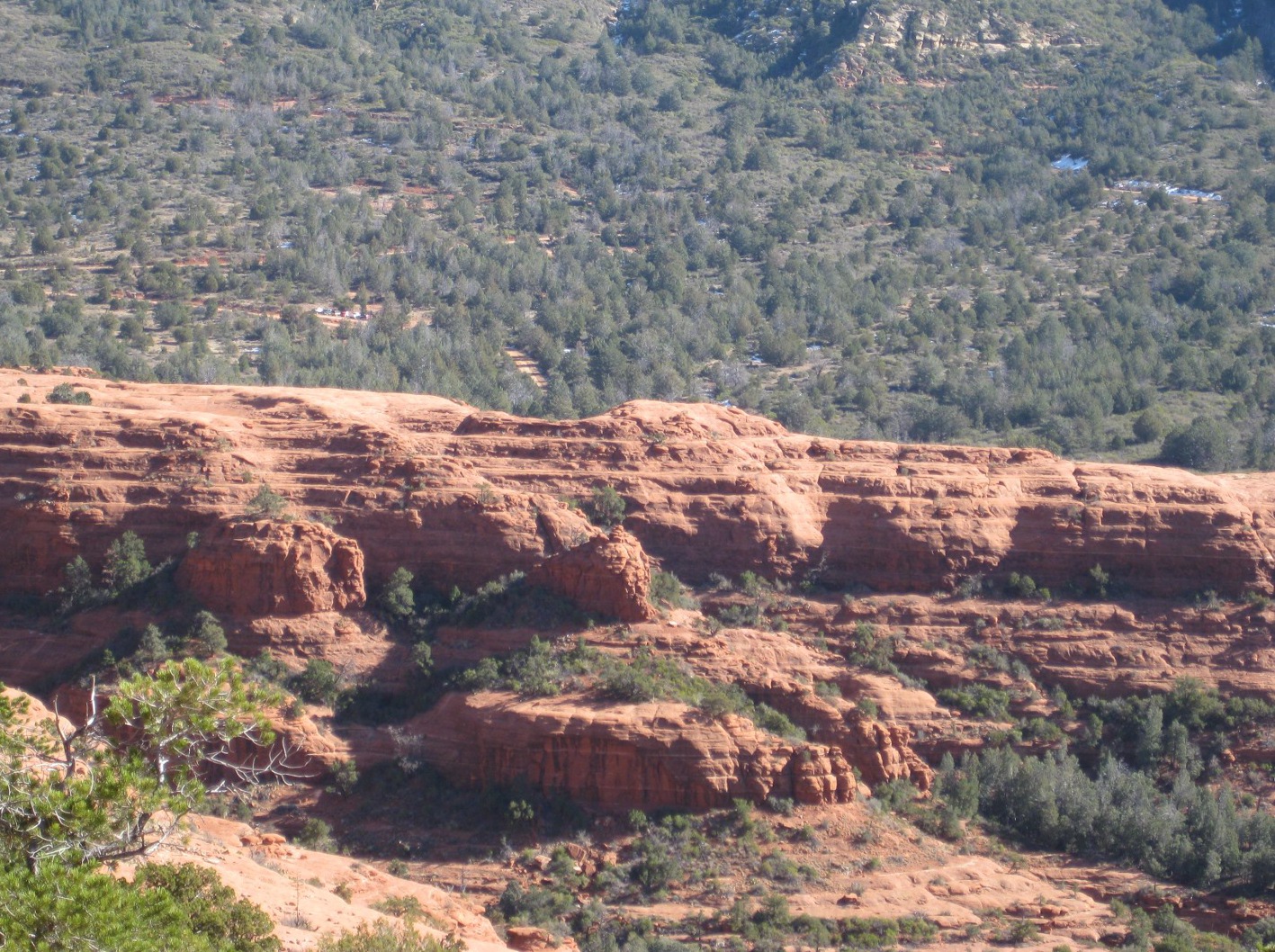
Shortly
after leaving the trailhead we stopped at an open area to look across
to the Cowpies and on to the gap in Mitten Ridge that was our
destination for today’s hike.
 |
| Taken just over a tenth of a mile from the trailhead. The Cowpies are the relatively flat formations just beyond the hikers shown standing on the edge of a cliff. The gap in Mitten Ridge (to the right) is where we ended our hike |
We continued across the open area
to the cowpie formations beyond , climbing to the top of the highest
one for a view of the canyons below surrounding area. Looking to the
north, we could see see the faint trace of Schnebly Hill Trail making
its was diagonally up the mountain, along the original Schnebly Hill
Road, to the Mogollon Rim. Visible below the trail was the
Merry-Go-Round (or Carousel) formation.
 |
| The Merry-Go-Round formation (center right) and Schnebly Hill Trail snaking up the ridge, following the trace of the original Schnebly Hill Road, toward the Mogollon Rim |
Turning
to the south we had a good view down Bear Wallow Canyon and across
Sedona to Mingus Mountain in the distance. Munds Mountain loomed
across Bear Wallow Canyon to our left and Cowpies Canyon ran down
from our right to join Bear Wallow just below the Cowpie formations.
Looking farther down the canyon, and across Sedona, Mingus Mountain
was visible in the distance.
 |
Bear Wallow Canyon (left) and Cowpies Canyon (right) running together just below our vantage point
|
 Closer
in, was a lone tree (see
right) that seemed to be
growing from bare rock just below the rim of Cowpie Canyon.
Closer
in, was a lone tree (see
right) that seemed to be
growing from bare rock just below the rim of Cowpie Canyon.
We
stopped for a snack and then retraced our way from the Cowpie
formations around the head of Cowpie Canyon and rejoined the trail
running along the side of Mitten Ridge toward the gap.
(NOTE:
According to some reports I have read, the trail is called Cowpies
Trail from Schnebly Hill road to the point where we turned to hike on
the Cowpies and Mitten Ridge Trail the rest of the way to the gap.
I decided to avoid a decision by just referring to the whole length
as Cowpies-Mitten Ridge Trail.).
Along
the trail we found a particularly striking view of Arizona Cypress
trees against a backdrop of red cliffs.
 |
| Arizona Cypress against the red rock. Note the window in the rock spire at the top left of the tallest tree. The Schnebly Hill Trail is faintly visible, running up Schnebly Hill to the Mogollon Rim in the upper right. |
The
trail between the head of Cowpie Canyon and Mitten Ridge Gap is
indistinct in some places and the last few hundred yards are a pretty
steep climb. However, don’t be discouraged, as you really
can’t go too far wrong if you just keep heading toward the gap, and
the view from the gap is well worth the short climb. At the gap
we stopped to enjoy the views while we ate lunch. Some of these
views are shown below and on the following pages.
To
the east we looked down on the Cowpie formations. Cowpies Canyon
runs down this side of the bare red ridge shown here, Bear Wallow
Canyon runs down the other side and Munds Mountain, already showing a
few scattered patches of snow, looms beyond.
 |
The Cowpies formations from Mitten Ridge Gap. The hump in the middle of the photograph is the highest cowpie
|
To the west, we could
look down into Oak Creek Canyon, across Oak Creek and Midgley Bridge
and on to the Cliffs on the other side of the canyon.
 |
A view into Oak Creek Canyon showing Midgley Bridge and looking out across Sedona - Taken from Mitten Ridge Gap
|
 |
This outcropping from Mitten Ridge forms the south side of Mitten Ridge Gap
|
 |
This is the cliff that forms the north side of Mitten Ridge Gap
|
After
lunch we returned directly by way of the Cowpies-Mitten Ridge Trail
to the parking area.
The
total hiking distance for this hike was 3.6 miles according to my GPS
log. The distance from the Cowpies Trailhead at Schnebly Hill
Road to the end of the trail at Mitten Gap, without the excursion to
the Cowpies, is 1.2 miles.
Our
GPS track for this hike is shown on the included map (below)

No comments:
Post a Comment