Despite
a predicted 60% chance of rain, we set out on 27 July 2013 to make a
loop hike around Bismarck Lake. To do this we planned to start at
the Bismarck Lake Trailhead, hike on that trail past the lake and
join with the AZ Trail. We would then follow the AZ Trail north
until we came to an old road that would take us to Little Spring.
From Little Spring, we planned to bushwhack our way back across a
ridge that separated it from Bismarck Lake.
We
left Cottonwood a bit after 0700, but I had to stop for gas and it
was about 0730 when we left Cornville after picking Lila up there.
We took I-17 to Flagstaff, continued straight on Milton when the
freeway ended, passed under the railroad overpass, took the sharp
right turn and turned left onto US Hwy 180 (Humphreys Street). We
drove 12.2 miles from the end of I-17, passing the turnoff to
Snowbowl along the way, to turn right onto FR 151 just after passing
mile marker 235. About 6.4 miles along FR 151, we came to the
Bismarck Lake turnoff. We turned right onto that road and drove 0.6
miles to the Bismark Trailhead. We donned our gear and paused for a
group photograph.
 |
Left to right: Betty Wolters, Miriam Sterling, Kwi Johnson, Lila Wright and
Ellis Price – photograph taken by the sixth hiker using the authors camera
|
We
found an informative sign, providing distances and other pertinent
information, posted at the beginning of the trail.
 |
Bismarck Trailhead sign
|
 A
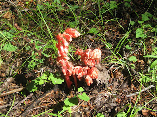
short distance ahead we started to see pinedrop plants (right) along the way. This plant lives
in a parasitic relationship with, and derives all its carbon from, a
fungus which itself colonizes a host plant's roots.
The
trail rose at a gentle slope along an old road, now blocked by a
fence and several mounds of earth to prevent vehicular traffic. It
passed at first through a heavily forested area and then skirted a
verdant meadow with a few trees scattered about.
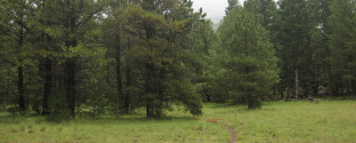
The
meadow is shown in the following photograph (below)
taken on the way back down the trail.
 |
Meadow between the trailhead and Bismarck Lake – taken on the way back
|
There
were several flowers scattered alongside the trail. Predominate
among these were blue to purple flowers that I at first took to all
be lupines. However, I later found that they were mostly loco weed.
 |
| Lupine |
 |
| Locoweed |
Above,
the leaves of the lupine are arranged around the stem in clusters
while the locoweed has a fern-like arrangement.
About
eight-tenths of a mile from the trailhead, we arrived at a fork in
the trail. By bearing left, we could go directly to Bismarck Lake,
continuing straight ahead would take us to the Arizona Trail. We
continued straight and were soon at another sign. Both signs are
shown below.
 |
Bismarck Lake is 0.2 miles to the left
|
 |
We arrived at the Arizona Trail
|
We
turned north on the Arizona Trail, going toward Forest Road 418, and
were soon traveling through a cool forested area along the bottom
slope of Humphreys Mountain just outside the Kachina Wilderness area.
 |
On the Arizona Trail – note the unique trail sign on tree in center
|
Lila
had recently hiked this section of trail and had noted a hand-written
sign pointing out the way to Little Spring. That observation led to
this hike and our plan to loop around Bismarck Lake. However, when I
laid out the hike and plotted a proposed GPS track, I used the route
of an old road shown on my map that left the Arizona Trail at a
closer spot. When we came to the old road, we had not reached the
sign Lila had seen, so we continued along the trail for a short
distance farther before stopping for a snack and to decide whether to
return to our plotted track. One member of the group went ahead for
about another quarter of a mile and returned to say that he had not
reached the sign. Also, it was now threatening to rain, so we
decided to return to the plotted track.
Shortly
after we started down the old road, the rain started to fall and we
stopped to don ponchos.
 |
In our ponchos we were indeed a colorful lot.
|
 Now
protected from the rain, we continued on our way along the
well-defined trail. The rain was intermittent and between showers
the butterflies came out to play on the locoweed (left)
growing in the old roadbed.
A
little over half a mile from the Arizona Trail we came to a junction
with what was once FR 418B, but was now long unused as a road. We
turned west on it and continued toward Little Spring. Then, about
0.5 miles ahead we turned off of old 418B and followed another road
for about 100 yards to arrive at Little Spring.
 From
here we intended to bushwhack our way back to Bismarck Lake.
However, we noted a fairly well-worn trail leading up the mountain in
the general direction we wished to go and decided to give it a try.
As we started up the trail, I saw a beautiful berry-laden bush
(right)
growing alongside the trail. Luckily, no one tried eating the
berries, as I later learned it was poisonous red baneberry, sometimes
called snakeberry.1
 The
trail we were following led sharply up the mountain for a distance
before leveling off a bit. Not far from Little Spring, we found an
ancient tree with many dead branches. An attached Forest Service
sign (left) proclaimed it to be a
Wildlife Tree, not to be cut.
The
trail became a bit obscure at one point where it detoured around a
fallen tree. Other than that one spot, it was clear and easy to
follow. Additionally, a quick peek at my GPS showed that we were
following closely along the track I had plotted to guide what we had
thought would be a bushwhacking trip from Little Spring to Bismarck
Lake.
Along
the way we saw numerous old carvings, such as were left by Basque
sheepherders, on the aspen trees. One tree had both what appeared to
be a cross and a spaceship (or rocket).
 |
| Cross |
 |
Spaceship (or rocket)
|
Once
we had topped the ridge, the trail sloped gently down and the going
was easy.
 |
Section of Little Spring-Bismarck Lake Trail sloping gently down to the lake
|
We
stopped at the lake for lunch and, having long since removed them,
now used our ponchos to protect us from the wet grass. We had a
great view across the lake to the cloud-shrouded slopes of Mount
Humphreys.
 |
Looking across Bismarck Lake to Mount Humphreys-Agassiz
|
From
here it was just a mile back to the trailhead and we were soon
approaching the end of this trail.
 |
Approaching the Lake Bismarck Trailhead
|
Our
track is shown in red on the included map (below). The dark green track is the road from FR 151
to the Bismarck Lake Trailhead. The light green track shows the
continuation of FR 151 toward its junction with FR 418. A section of
the Arizona Trail is shown in yellow.
The
Bismarck Lake Loop hike was exactly 5.0 miles according to my GPS.
That is the trailhead to trailhead distance and excludes the extra
distance we hiked on the Arizona Trail before turning back to follow
our plotted track. The elevation gain was 555 feet and the maximum
elevation was 8875 feet.
 |
| Bismark Lake Loop |
Having
finished the Bismarck Lake Loop in good time, we decided that we
would drive the short distance, only 3.1 miles, to Walker Lake and do
that hike too. We would then return to US 180 by way of the north
end of the FR 151 loop.
To
reach the Walker Lake Trailhead, we returned to FR 151 and drove
north, passing the Little Spring settlement on the way, until we
reached FR 418. We turned right (east) on FR 418 and drove about 0.2
miles to the first road on the left. According to my map the road is
numbered 9004S. It turns to the right after almost 0.3 miles and
continues for just over another tenth of a mile, for a total of 0.4
miles from FR 418. I later checked the Coconino National Forest
Motor Vehicle Use Map and found that this road is not listed.
However, it appears to be well-used.
After
traveling 0.4 miles from FR 418 we came to the Walker Lake Trailhead.
From here the road is definitely closed to all vehicular traffic.
 |
View of sign and the trail ahead
|
It
is just a short hike up the gently-sloping old road to the rim of the
volcanic crater in which the lake is located. I was hiking ahead of
the others and, just as I rounded a curve where the road turns to
cross the rim of the crater, a large doe jumped up right in front of
me. She, even more startled than I, lost no time in departing the
area. By the time I had traversed the few remaining yards to the
rim, she was just a fleeting figure far down the old road that once
led down to the lake.
 |
If you look very carefully, you can see the deer between the two dead trees
|
As
shown below, the lake is laid out with a mixture of woods and
grassland as a backdrop.
 |
Walker Lake
|
The
Hochderffer Fire of 1996 swept down into the bowl on the western
slope and destroyed the forest in patches.
 |
Looking along the western slope from inside the crater
|
The
included map (below) shows the
short Walker Lake hike in blue. The green track is the route we
drove to the trailhead. The magenta track is part FR 151 leading to
US 180, only about two miles away.
This
hike, as shown on the map, is only 0.6 miles round trip. The
elevation gain is 140 feet and the highest elevation is 8345 feet.
 |
| Hike at Walker Lake |
No comments:
Post a Comment