Coyote
Spring Trail had been on my list of trails to hike since 30 May 2009
when I passed the trailhead on a hike to Martin Canyon. I finally
got it placed on the Skyliner schedule for 14 November 2015. We took
Hwy 89A south through Jerome to the Mingus Summit and turned right
onto Forest Road 106, the paved road to Potato Patch Campground.
About 0.30 miles from the highway, we angled left to continue on FR
106. Another 0.10 miles brought us to a the end of the pavement at a
roughly circular graveled area with toilet facilities. We continued
on through this area and left it going generally Northwest, still
following FR 106 for about another 0.70 miles to arrive at Woodchute
Trailhead where FR 106 ends.
 |
Woodchute Trailhead at the end of FR 106 - the pedestrian gate (center) marks the beginning of Woodchute Trail
|
We,
however, were not taking Woodchute Trail, only borrowing a bit of
space in its parking lot. We donned our packs and left the parking
area heading west on FR 106D. At first this road was well-maintained
and had even been graveled recently. After about 0.2 miles, however,
we passed through a fence with an open gate and found ourselves on an
unmaintained dirt road. It was still passable for high-clearance,
4-wheel drive vehicles, but very questionable for other vehicles.
About
0.6 miles from the parking area we came to Hickey Tanks (plural
because two tanks are located close together) and an unsigned fork in
the road.
 |
Unsigned fork in the road at Hickey Tanks – the right fork is FR 106
|
Assuming
(correctly) that the left fork was primarily for access to the tanks,
we continued along the right fork and shortly came to a viewpoint
from which we could see into the Woodchute Wilderness.
 |
| Looking north across Martin Canyon, which runs behind the ridge marked by the peak at left, into the Woodchute Wilderness |
While
still at the viewpoint we posed for a group photograph, but we were
in speckled sunlight and it came out so distorted as to make me dizzy
just looking at it. I tried again later in the hike with even worse
results, somehow getting no exposure at all.
Approximately
0.3 miles west of the viewpoint we came to another fork in the road.
Here FR 106D turns to the left (south) and continues to Mingus Tank,
passing the turnoff to Hickey Mountain on the way. We continued
straight ahead on FR 106E and, after another 0.2 miles, arrived at
the junction with FR 9710W which leads down the mountain to Turkey
Tank and on to Martin Canyon. That is the route (although not
identified as FR 9710W at the time) that we followed on 30 May 2009
for a loop hike from Woodchute Trailhead to Martin Canyon and then up
the slope on Trail 104 to Woodchute Tank before returning to our
starting point by way of Woodchute Trail. This time, rather than
turning toward Turkey Tank, we continued straight ahead for another
0.1 mile to the Coyote Spring Trailhead. In May 2009 the trailhead
was marked with the trail sign as well as with an Adopt-A-Trail sign
indicating a trail sponsor (below left).
Now the Adopt-A-Trail sign is gone and the trail sign stands alone
(below right).
The
trail, at first well-used and easy to follow, led down the spine of a
ridge that separates Coyote Canyon, to the south, from Little Coyote
Canyon, to the north. We had left the ponderosa pine forest behind
and were now passing through an area populated mostly by junipers.
 |
A section of Coyote Spring Trail near the upper end of the trail
|
Around
0.2 miles from the trailhead the trail made a sharp turn to the right
and a less distinct path continued straight ahead to a viewpoint.
We stopped at the there and I did get a photograph of the other five
hikers as they enjoyed the view. Truthfully, I prefer such unposed
shots. It is , however, admittedly difficult to identify individual
hikers.
 |
Left to right: Jim Manning, Lila Wright, Karl Sink, Daisy Williams and Joanne Hennings
|
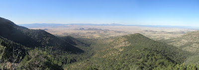
We spent some time at
the viewpoint enjoying the sweeping panoramic view which stretched
from Prescott Valley at the left, past Granite Mountain on the
western horizon to Chino Valley at the right.
 |
Panoramic view from Coyote Spring Trail Viewpoint
|
Reluctantly
leaving the viewpoint, we returned to the trail and continued down
the crest of the ridge for another 0.6 miles before the trail started
to angle down the southern slope into Coyote Canyon. By this time
the trail had become much less distinct and we had to stop
occasionally to get our bearings. Luckily previous hikers had placed
a few ribbons along the way. These markers were especially helpful
because the GPS track I had downloaded was wildly Inaccurate for all
but the last mile and a half of the trail.
After
about another 0.1 mile, most of the hikers wanted to stop for lunch
and head back. It was really quite early for lunch, we were still
about 0.75 miles from Coyote Springs and I really wanted to hike the
whole trail. But some of the group were concerned about the time it
would take to climb back up the steep trail we had descended and
thought that, if we continued, we would be very late getting home.
Accompanied
by Karl Sink, I continued for about another 200 yards to a point from
which we could clearly see the canyon mouth, the spot at which the
trail ends. Then, worried that we would be holding the rest of the
group up while they waited for us to return before heading home, we
turned back to join them for lunch. Later examination of my GPS
track and measurements on a map disclosed that we were 0.7 miles from
the end of the trail at Coyote Spring. To reach it we would also
have descended another 540 feet in that distance.
On
arriving where the rest of the hikers were eating, I quickly ate my
meal and settled in for a nap before heading back. Sometime later I
awoke to a disquieting silence. Looking around I saw no one and at
first thought that the entire group had left me behind. Then, with
some relief, I saw Karl's bright red backpack hanging on a nearby
bush. A closer look disclosed Karl, himself, sound asleep under the
bush. The other hikers, wide awake and still worried about the time
it would take to complete the steep climb ahead, had made the quite
sensible decision to let Karl and me finish our naps while they got a
head start back up the trail. After all there were two of us and we
both knew the way back. They may also have considered the well-known
fact that I tend to be a somewhat grumpy hiker when awakened too
soon from my noon nap.
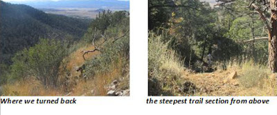
The
photographs below show the mouth of the canyon from where we turned
back (below left) and a hiker
struggling up the steepest part of the trail (below
right).
During
this hike we discussed other trails that some of us have hiked in the
area, especially the Martin Canyon/Woodchute Trail Loop and the
Hickey Mountain/Mingus Lake Loop hikes. To answer some of the
questions raised about those hikes, I am including the below map
insert that shows both of them along with today's hike. Martin
Canyon/Woodchute Loop is shown as a blue track, Hickey
Mountain/Mingus Lake Loop is shown as a cyan track. And Coyote Spring
is shown in red (the hiked part) and green (the unhiked portion).
 |
Showing Coyote Springs hike, Martin Canyon/Woodchute Loop hike and Hickey Mountain/Mingus Tank Loop hike.
|
The
GPS track is shown on the included map (below)
in red. The green line shows the short section of the trail that we
did not hike.
Two
sets of hike statistics are included below. The first is of the
trail as we hiked it from the Woodchute Trailhead to where we stopped
for lunch and turned back. The second set of statistics also
includes the short part, 0.7 miles, part of the trail that we did not
hike.
Our
hike today was 5.3 miles round trip, the maximum elevation was 7273
feet and the total descent was 1083 feet. Had we completed the hike,
the distance would have been 6.6 miles, the highest elevation would
still have been 7273 and the total descent would have been 1673.


No comments:
Post a Comment