Following
trips to Ireland in 2012 and Wales in 2014, Diana and I decided to
spend some time in England and Scotland in 2015. Thinking of the
weather and that we would be ranging at least as far north as
Edinburgh, we scheduled our trip for the last part of May.
I
took the airport shuttle from Cottonwood to Phoenix and stayed at the
Airport La Quinta Inn on the night of 13 May, flying on to
Washington, DC the next day. As I have done before, I chose a
flight with a stop in Chicago in order to fly into National Airport
in DC. That way I could take a short taxi ride to Diana's office and
ride home with her for an overnight stay before we continued on to
London on the 15th. On arriving at the airport security
checkpoint at Phoenix Sky Harbor, I found that I had been entered in
TSA PreCheck, possibly because I am classified as elderly. I had not
even noted that my boarding pass was so marked until a TSA employee
pulled me out of the regular line and redirected me.
 After
a good night's sleep, we took an early morning taxi to Dulles Airport
and caught a flight to London, arriving there in time for
another good night's sleep; that enabled us to avoid jet lag. Diana
was also entered in PreCheck, likely because we were traveling
together and I had made the reservations. I think that TSA must have
found that they had idle employees manning their PreCheck lines part
of the time and decided to move low-risk travelers to that line as an
efficiency measure. We arrived at Heathrow in London a few minutes
early, caught a taxi to a Ibis Hotel. I selected the Ibis because it
seemed to specialize in spartan but comfortable and economical rooms (right).
I was not disappointed and we stopped for an additional two nights
at another Ibis in Newham, the Dockland area of London.
After
a good night's sleep, we took an early morning taxi to Dulles Airport
and caught a flight to London, arriving there in time for
another good night's sleep; that enabled us to avoid jet lag. Diana
was also entered in PreCheck, likely because we were traveling
together and I had made the reservations. I think that TSA must have
found that they had idle employees manning their PreCheck lines part
of the time and decided to move low-risk travelers to that line as an
efficiency measure. We arrived at Heathrow in London a few minutes
early, caught a taxi to a Ibis Hotel. I selected the Ibis because it
seemed to specialize in spartan but comfortable and economical rooms (right).
I was not disappointed and we stopped for an additional two nights
at another Ibis in Newham, the Dockland area of London.
Bright and early on the
morning of 16 May we ate breakfast and headed out to see the sights
of London. We had decided to take a Hop-on Hop-off bus tour and a
riverboat cruise on the Thames.
It
was Saturday morning and, as we walked to the bus stop to catch a bus
to the subway “tube” station, we came upon a group of “tin man”
lookalikes celebrating the start of the weekend. At least we think
that is what they were doing because when asked their only response
was, “hey, it's the weekend.”
 |
| “Tin man” lookalikes cavorting in the parking lot at the Holiday Inn |

Physically,
London is an exquisite mixture of the very old, the very new and
everything in between, all melded into a harmonious whole that is
visibly being reshaped as one watches. Just in the area around
Parliament Square, for instance, Westminster Abbey (shown
below) was constructed beginning in 1245, the nearby
Palace of Westminster (Houses of Parliament) was rebuilt after a
major fire in 1834 and Portcullis House, built to augment limited
space in the Palace of Westminster, was opened in 2001.
 |
Westminster Abbey seen from the bus stop at College Green (Abingdon Street Gardens)
|
The
photograph below shows Big Ben (center) located at the north end of
the Palace of Westminster and a portion of Portcullis House (lower
left) with the London Eye on the other side of the Thames visible in
between.
 |
Portcullis House, the London Eye and Big Ben
|
 The
London Eye (right), a 443 foot high
Ferris wheel on the south bank of the Thames, was built in 1999 to
commemorate the millennium. The 394-foot diameter wheel was
assembled lying flat on piled platforms (or temporary islands) in the
river and then lifted into position. The first lift attempt failed
and David Marks, one of the architects is quoted as reporting that
“Virgin
[Airways] had fun with that,
since British Airways was sponsoring the Eye. Richard Branson flew a
balloon overhead that said: 'BA can’t get it up!1'”
Since the millennium the Eye has been sponsored by Merlin
Entertainments, EDF Energy and, currently, by Coca-Cola.
The
tall, top heavy structure at the left in the below photograph is the
Walkie-Talkie Building. Completed in 2014, this 525-foot, 37-story
skyscraper is the thirteenth tallest building in London. The
distinctive shape of the building resulted in the reflection of
sunlight into streets to the south during construction with a
concentration up to six times the heat of direct sunlight.2
The developer has received planning commission to install a
“brise soleil” sunshade as a permanent solution to the problem.3
 |
New London Skyscrapers (left to right): The Walkie-Talkie, the Cheesegrater and the Gherkin
|
The rightmost of the
three skyscrapers shown above is the Gherkin. Completed in 2003,
this 591-foot, 41-story building is the ninth tallest building in
London. In November 2014 the building was sold for £726,000,000.
Construction
in the city continues apace as evidenced by the many cranes dotting
the skyline.
 |
Current construction activity is evidenced by the many cranes dotting the skyline
|
 |
An old, familiar London icon, Tower Bridge as seen from London Bridge
|
 |
| Diana in vest and long sleeve shirt |
 |
Ellis in a hooded jacket
|
 |
Tower of London
|
During
our bus tour, we had noted a statue of Queen Boudica, the warrior
queen of the ancient Iceni tribe, who is reported to have destroyed
the Roman city of Londinium, precursor of London, in about AD 60.
 |
Boudica, warrior Queen of the Iceni Tribe
|
Our
first stop the next day was Guildhall Art Gallery and London's Roman
Amphitheatre. Guildhall, built in the 15th century and still the headquarters of the City of London Corporation.6
The adjacent Guildhall Art Gallery was built in 1885. During
restoration work to the gallery in 1988, the remains of the Roman
Amphitheatre were discovered and the building was redesigned to
incorporate the new findings.
 |
Guildhall – Guildhall is straight ahead, Guildhall Art Gallery is at right
|
The
display is completely blacked out except for a few strategically
placed spotlights that provide only enough light to permit safely walking
through the exhibit. One enters by walking up the passage at the
east gate into the arena. To the left and right are what is left of
the stone foundations. Beneath the visitors feet, under glass, are the wooden remains of a drain system embedded into the floor. Ahead
is a luminous sketch outlining the interior of the amphitheatre
as it must have been in Roman times. Similarly, luminous
reproductions of human figures, including gladiators, are scattered
about.
 |
Londinium's (London's) Roman Amphitheatre
|
The below map,7 available on Wikimedia, shows Londinium as of about AD 400. Note
that the location of Londinium's Roman Amphitheatre is shown by the
elliptical shape on the map.
 |
Londinium in about AD 400
|
The
museum also has extensive exhibits representing other periods, from
prehistory to modern times. One of these exhibits displays bone
fragments, tools and weapons covering the period from 38,000 BC to
4000 BC.
 |
| The attached label identified the objects shown as follows: Items 1 – 3 (People and animals, 30,000 – 11,000 BC); Items 4 – 7 (Spear tips and long blades, 11,000 – 9500 BC); Items 8 – 14 (Flint and antler tools, 8500 – 6500 BC); Item 15 (Flint arrow tips, 6500 – 4000 BC) |
 |
Artifacts recovered from a brick-lined well at 21 Union Square in London
|
The
trip from our hotel in London to the hotel in Chippenham would only
take about 2.5 hours. That left us time on the 18th to
visit a few of the remaining sections of the old London Wall before
catching the train to Chippenham. We had actually seen a section of
the wall the day before, near Tower Gateway where we caught the
Docklands Light Railway back to our hotel and we would start by
taking another look at that section. We hoped for better lighting
this morning than had prevailed the evening before.

 We
were not disappointed. I was able to get a much better photograph
(right) in the morning light. I
also remembered that we had seen another section of the old wall
while visiting the Museum of London, itself located at 150 London
Wall, a street that runs for a distance along the course of the old
wall. This particular section of wall (left)
is visible as one approaches the entrance to the museum.
We
were not disappointed. I was able to get a much better photograph
(right) in the morning light. I
also remembered that we had seen another section of the old wall
while visiting the Museum of London, itself located at 150 London
Wall, a street that runs for a distance along the course of the old
wall. This particular section of wall (left)
is visible as one approaches the entrance to the museum.
Below,
behind a bronze statue believed to depict the Emperor Trajan, is
shown a well-preserved section of London Wall.
 |
Statue of Emperor Trajan in front of a section of London Wall
|
 This
photograph (right) shows a section
of the old wall as it has been modified and added to over the
centuries. According to what I have been told, the lower section,
marked by layers of red rocks, are part of the original Roman wall.
The wall shows additions and repairs, including brick and concrete,
made over the course of centuries. The brick wall of a more modern
building is shown at left.
This
photograph (right) shows a section
of the old wall as it has been modified and added to over the
centuries. According to what I have been told, the lower section,
marked by layers of red rocks, are part of the original Roman wall.
The wall shows additions and repairs, including brick and concrete,
made over the course of centuries. The brick wall of a more modern
building is shown at left. |
A relatively large still-intact section of London Wall
|
Our
tour guide picked us up at 1030 the next morning and we were on our
way to Stonehenge, about 25 miles away. About 1.5 miles west of the
stones, we found a large, modern visitor's center complete with gift
shop, cafe,
ticket office, car and bus park, exhibition on the history of the
site and even a site specific museum. For those who have no wish to
walk, a shuttle bus ferries visitors to the stone circle.
As
for the history of the site, most of the information presented in the
next five paragraphs is available at www.stonehenge.co.uk.9

 I
clipped a view of an Aubrey hole11
from a 2006 picture (right) as it
appears on the wikimedia.org site. According to the description it
is Aubrey hole number 21.
I
clipped a view of an Aubrey hole11
from a 2006 picture (right) as it
appears on the wikimedia.org site. According to the description it
is Aubrey hole number 21.
Around
2150 BC, some 82 bluestones were transported to the site from the
Preseli mountains, in south-west Wales. These stones, some weighing
four tons, are thought to have been dragged on rollers and sledges
for part of the 240-mile journey and carried on rafts by water for
other parts of the trip.
The
Sarsen stones (sandstone blocks) were brought in from north
Wiltshire, some 25 miles away in about 2000 BC. These stones,
weighing around 50 tons, must have been moved using sledges and
ropes. It has been calculated that it would have taken 500 men to
pull one stone.
Finally,
not long after 1500 BC, the bluestones were rearranged in the
horseshoe and circle seen today. These stones are thought to have
originally numbered around 60. Many of these have been removed or
broken up with below ground stumps remaining of some.
The
guide turned out to be one of those individuals who romanticize the
past. He seemed to see Stonehenge and other such ancient manmade
marvels as the results of voluntary labor, somewhat akin to a
“rearing” (“barn raising” in the United States). He
expressed the belief that the introduction of agriculture and
development of settlements destroyed civilization. I think he also
sensed spiritual presences among the old stones.
Call
me a pessimist if you will, but I envisioned the hard work being done
by slaves captured from neighboring tribes or tribesmen in fear of
damnation by pagan gods conjured up by a cast of avaricious,
vainglorious priests. I was also undisturbed by any spiritual
presences.
We
took the shuttle bus from the visitors center to the site, arriving
to find that only a few other visitors there at the time.

 |
| Stonehenge |
According
to English Heritage, “Avebury rivals - some would say exceeds -
Stonehenge as the largest, most impressive and complex prehistoric
site in Britain.” The same source indicates that the site was
“built and altered over many centuries from about 2850 BC to
2200 BC” and notes that the circular bank and ditch enclose an
area of 28.5 acres which includes part of Avebury village.
As
also noted by English Heritage, “Avebury is part of a wider
complex of Neolithic and Bronze Age monuments, with many other ritual
sites in English Heritage care. West Kennet Avenue joined it to The
Sanctuary, and another stone avenue connected it with Beckhampton.
West Kennet Long Barrow and Windmill Hill are also nearby, as is the
huge and mysterious Silbury Hill. This extraordinary assemblage of
sites seemingly formed a huge 'sacred landscape', whose use and
purpose can still only be guessed at. Avebury and its surroundings
have, with Stonehenge, achieved international recognition as a World
Heritage Site.” These sites are identified on a poster map
(see large map below) which is posted at
the West Kennet car park.
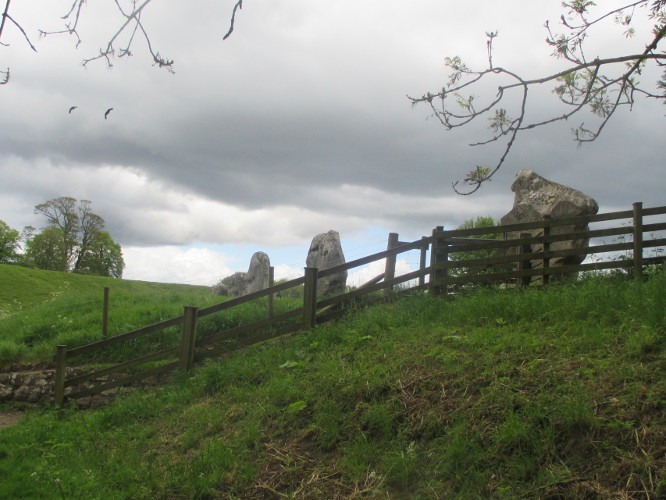 We
had scheduled the visit to Avebury primarily to see the large
prehistoric stone circle, according to the National Trust the world's
largest.12
When we arrived we parked very near a pathway that would lead us up
a short slope from the road, through a gate and into the field
(right) containing the first of the
stones.
We
had scheduled the visit to Avebury primarily to see the large
prehistoric stone circle, according to the National Trust the world's
largest.12
When we arrived we parked very near a pathway that would lead us up
a short slope from the road, through a gate and into the field
(right) containing the first of the
stones.
However,
we first walked through the grounds containing Avebury Manor and
Garden, the museum, the cafe and St James Church. We bypassed
everything but the church which dates from 1000 AD and is still in
use. The old church has many interesting features, including but
certainly not limited to, several beautiful stained-glass windows and
an interesting barrel font.
The entrance to the
church is shown below. The church tower, partly obscured by a tree,
was added in the 1500s. The church grounds are, as might be
expected, almost entirely taken up by the surrounding burial sites.
The grounds and indeed the entire church site is
well-maintained and presents a most pleasing and restful place for
the pilgrim in need of rejuvenation.
 |
| Poster map posted at West Kennet car park |
 |
Entrance to St. James Church at Avebury
|

The
church nave is shown below; the decorated cylindrical object seen in
the lower left corner of the photograph is the font cover.
 |
St. James Church nave
|


Leaving the church, we crossed the road and proceeded up the path to the stone circle. The stones at Avebury are smaller than those at Stonehenge; however, the circle is much larger. Also one can walk among them and actually touch the stones.
 |
Part of the stone circle at Avebury
|
 Diana
is shown here (right) examining one
of the stones close up. One of the stones had what appeared to be a
naturally-formed channel that funneled sound so as to amplify it.
One could speak into the opening at one end of the channel and the
words would emerge significantly amplified from the the other end of
the channel. Our guide seemed to think this amplification had some
spiritual significance.
Diana
is shown here (right) examining one
of the stones close up. One of the stones had what appeared to be a
naturally-formed channel that funneled sound so as to amplify it.
One could speak into the opening at one end of the channel and the
words would emerge significantly amplified from the the other end of
the channel. Our guide seemed to think this amplification had some
spiritual significance.
 |
Postulated original layout of Avebury
|
 While
the tourists might find the stones meaningful and exciting, this
horned sheep (right)
took a more prosaic view. She just thought one of the stones made a
great spot to rest in the shade. I thought the day a little chilly
myself and actively sought out the sun, but the sheep was wearing a
wool coat.
While
the tourists might find the stones meaningful and exciting, this
horned sheep (right)
took a more prosaic view. She just thought one of the stones made a
great spot to rest in the shade. I thought the day a little chilly
myself and actively sought out the sun, but the sheep was wearing a
wool coat.
West
Kennet Avenue, a Neolithic Era processional road leading to Avebury
Henge from the Sanctuary, located 1.6 miles to the southeast, is
lined on both sides by large upright stones. After leaving the
henge, we stopped a short distance from Avebury as we were on our way
to West Kennet Long Barrow to look back at the old roadway, now
filled with grass and wildflowers, as it stretched in a gently
curving line back toward the henge.
 |
West Kennet Avenue, looking toward the Avebury Henge
|
Its
function remains a mystery: possibly it enshrined the dwelling place
of some revered person, and certainly huge numbers of human bones
were found here, accompanied by food remains suggesting elaborate
death rites and ceremonies. Later, West Kennet Avenue was constructed
to connect it with newly-built Avebury, reinforcing the status of
this enigmatic but clearly very important site.”16
A
1743 drawing by William Stuckeley illustrates the connection between
Avebury Henge and the Sanctuary along with another avenue that ran to
the southwest from the henge. Stuckeley theorized that “ the
two avenues were part of a giant 'snake' winding across the landscape
with its head at The Sanctuary and also incorporating Avebury
itself.”17
 |
Public domain drawing by William Stuckeley18
|
English
Heritage describes West Kennet Long Barrow as, “One
of the largest, most impressive and most accessible Neolithic
chambered tombs in Britain. Built in around 3650 BC, it was used for
a short time as a burial chamber, nearly 50 people being buried here
before the chambers were blocked.”19

 |
West Kennet Long Barrow entrance – seen from the north
|


We had, on the way up the
chalk hill to the cavern, noted a uniquely-shaped hill located just
across the way to the northwest. It looked somewhat like an old
volcanic cone. Our guide identified it as Silbury Hill and informed
us that it was manmade. English Heritage says, “the
largest man-made mound in Europe, mysterious Silbury Hill compares in
height and volume to the roughly contemporary Egyptian pyramids.
Probably completed in around 2400 BC, it apparently contains no
burial. Though clearly important in itself, its purpose and
significance remain unknown. There is no access to the hill itself.”
As we descended from West Kennet Long Barrow on our way back to the
car park we had an unobstructed view of Silbury hill across the
yellow, rapeseed-covered fields. The rapeseed fields and Silbury
Hill are shown in the following photograph.
 |
Silbury Hill seen across rapeseed fields
|
As
it were, the theft drastically altered our plans; we gathered our
wits about us and decided what we would have to do to recover from
the loss of our belongings. For me it was straightforward. I would
just need to find an outdoors store where I could purchase a new
shirt, pants, socks and underwear. In addition to that, because I
had carried a flash drive containing all of my passwords in my
backpack I needed to make a few quick online password changes. The
flash drive was encrypted and I was not too concerned but did
consider it prudent to change the most important ones.
Diana,
on the other hand, felt that with the loss of her smartphone all of
her passwords could have been compromised, so she had a lot more work
to do. She also had to obtain an emergency passport. We thought
first that we would just take the train back to London and obtain a
passport at the American Embassy there. But, although the embassy's
website implied otherwise, actually making an appointment turned out
to be virtually impossible. The telephone answering system is
seemingly designed to make sure one never really accomplishes
anything. She finally gave up in disgust and tried the consulate in
Edinburgh, finally managing to get an appointment for the following
Tuesday.
The
following day we visited the Wiltshire County Police office to obtain
a copy of the police report of the theft. To our surprise, we were
told that those reports were only released to insurance companies.
They were, however, quite anxious to help and finally decided that,
since the American Consulate required a copy of the report in order
to issue a replacement passport, they could at least provide a
document verifying that such a report had been made and specifying
the report number.
Next
we walked to the station and caught a train to Swindon, the closest
town with a discount outdoor clothing and equipment store. The
store, GoOutdoors, was part of a chain nationwide chain and turned
out to have everything we needed except, strangely enough, underwear
which we later found at a Tesco supermarket. Having replaced the
essentials, we stopped at the restaurant attached to GoOutdoors to
eat and plan our next move. I had canceled all of our reservations
for the next few days, so we needed to decide where we would stay
tonight. I had made the reservations through Booking.com because of
the convenience and because they clearly state cancellation policies.
Usually, cancellation without charge is possible within two days of
arrival, sometimes even as little as one day. In our case, the only
fee we had been charged was for the stay we had scheduled for that
night in Cirencester and now, finding that we still had time plenty
of time to travel there by bus, I went online and reinstated that
reservation.
We
had verified that our Bed and Breakfast in Cirencester, the Talbot
Inn, had Wi-Fi, so we would be able to continue cleaning up the mess
caused by possibly compromised passwords and complete arrangements
for next Tuesday's appointment at the consulate in Edinburgh. We
would also need to print documents such as copies of Diana's old
passport, her drivers license and birth certificate. Luckily,
between us we had digital copies of all of those documents and had
found that most places we stayed would willingly print documents for
us if we just e-mailed them as pdf attachments.
On
checking in at the Talbot Inn we found the accommodations to be
quite satisfactory and the lady who showed us to our room assured us
that the Wi-Fi reception in our room was the best. Oddly, however,
she seem a little hesitant about the point. Soon, we were to find
out why; the very best Wi-Fi connection in Cirencester is less than
adequate. We couldn't even get a good enough connection to reliabye
send e-mail. One message I sent to Rosemary, just disappeared and
didn't even show up in my out box. We finally visited the local
library and used their computers. The system there was also very,
very slow but it did at least work after a fashion and Diana was able
to print some of the documents she needed for the consulate.
We
wound up staying three nights in Cirencester instead of the planned
two nights. We were too stressed out and still too busy trying to
recover from the theft to worry much about sightseeing. We mostly
just explored the town on foot and visited stores to replace a few
additional items such as my camera battery charger. Diana also found
a package that she could purchase which enabled us to access the
cellular network with our Kindles. It came with a data package
adequate to last us for the rest of our trip. That way we could
access the web anywhere we had cellphone service.
We
did finally make time for a visit to the local Corinium Roman Museum.
Corinium Dobunnorium was the name of a Roman settlement at the
present site of Cirencester. According to English Heritage, “one
of the largest Roman amphitheatres in Britain, built in the early 2nd
century” was located there. “It served the Roman city of
Corinium (now Cirencester), then second only in size and importance
to London, and had a capacity of around 8,000 spectators”20.
My
camera battery was low and I didn't take any pictures while in the
museum, but I did later find some interesting photographs that will
serve to illustrate the kind of artifacts they had on display. My
personal favorites were a large tile mosaic of a tiger and of a high
relief sculpture of three goddesses.
The
Corinium Museum website identifies the three goddesses as, “Mother
Goddesses” of the “Iron Age” or “Early Roman”
Period. It goes on to say, “The fruit and bread in their baskets
help to identify these carved figures. Perhaps they were objects of
prayer to provide a plentiful harvest with food on the table all year
round.”23
 |
| Floor tile mosaic 21 |
 |
| Three goddesses22 |

Leaving
Cirencester and the Cotswolds behind, we took the bus and a train to
Newcastle. That turned out to be a very frustrating all-day trip.
We were no sooner than settled on the train than I received an e-mail
from my bank indicating that there was a problem with a cash
withdrawal made just before we left Cirencester. The train kept
going through tunnels and densely populated downtown areas where we
lost the cell signal and we worked for a couple of hours attempting
to contact the bank.
Finally,
we just called Rosemary and had her contact them for us. As it
turned out, I had first tried withdrawing £400 and then reduced it
to £300 upon receiving a message saying that was over the limit.
The machine then recorded both amounts as withdrawals. The bank
promptly refused to recognize the £400 amount and automatically sent
me a notice because two withdrawals had been attempted within a very
short period of time at the same machine. Rosemary soon got the
matter straightened out and notified us by phone, but it all made for
a very frustrating train ride.
We
arrived in Newcastle Upon Tyne and walked to our hotel, Jurys Inn.
It was Saturday, 23 May and we planned to stay two nights, traveling
on to Edinburgh on Monday in order for Diana to keep her appointment
at the American Consulate on Tuesday. We had no specific plans for
Newcastle other than just goofing off for a day and resting up for
Edinburgh. Jurys Inn was a very good place for that. Our room was
comfortable, the service was excellent and they had a good restaurant
on site.
We
did take a short walk on Sunday just for the exercise and to purchase
our train tickets for the next day's trip to Edinburgh. The
half-mile walk to the train station took us through Times Square and
a large building labeled the International Center for Life, described
as a “science
village based in the heart of Newcastle
upon Tyne where
scientists,clinicians,
educationalists
and
business
people work
to promote the advancement of the life
sciences”.25
At Times Square we also noted a place called Think Tank? Of which
one customer wrote, “Great
venue for small gigs, had a great time. Although barman was very
impatient and unnecessarily rude”.26
Next door to the Think Tank? Was a night club called Digital which,
if the Google reviews are to be believed, has a high-quality sound
system and amazing DJs. That probably just means it is very, very
loud.
On
Monday, we made a late morning of it with a leisurely breakfast and
caught the train to Edinburgh just before noon. Arriving at
Edinburgh's Waverley Station at about 1430, we took a
taxi to the Holiday Inn Express on Cowgate. Actually, it would have
been just a short walk, but we didn't trust the Google directions for
walking as they seemed to take us on a route where no streets
existed. Later, we learned that the directions would have taken us
on a shortcut through a “close”, or alleyway, in this case with
steps. It appears that closes were originally private property. At
least in this case, however, it is now a commercial passage,
Fleshmarket Close that runs between Market Street and High Street
(Royal Mile), crossing Cockburn Street. A small pub, the Halfway
House, is located between Market and Cockburn Streets. Fleshmarket
Close was featured in Ian Rankin's novel Fleshmarket
Alley, an
Inspector Rebus novel.
If
one leaves the close and follows Cockburn Street to High Street, one
will pass The Baked Potato Shop at 52 Cockburn Street, an excellent
place to enjoy a stuffed baked potato. Baked potatoes are available
at a number of places in Edinburgh and can be filled with a variety
of ingredients such as hummus and roasted vegetables (my favorite).
Diana and I ordered baked potatoes several times as our main course
while in Edinburgh.
The
Holiday Inn Express on Cowgate turned out to be a very accommodating
place. Its only real drawback was that the business center turned
out to be a single computer in the lobby for which they charged an
exorbitant fee. As is normal for this hotel brand Wi-Fi was free and
about the only use for the computer in the lobby was for
such tasks as printing documents such as airline boarding passes or,
in our case, one final document that Diana needed to obtain her
passport. Luckily, the hotel staff seemed to understand the futility
of attempting to make money by renting a computer in a hotel that
offered free Wi-Fi and volunteered to print documents, e-mailed to
them by guests, on the office computer. So Diana soon had the final
document she needed for the next day's trip to the consulate.

 I
walked with her the next morning to the consulate on Regents Terrace.
The trip was only 0.6 miles by way of Cowgate, St Mary's Street,
Canongate (Royal Mile), down Old Tool Booth Wynd (left) to Calton Road and then up
Calton Hill by way of a steep, paved path (right) to end at the intersection of Regent Terrace and Regent
Road.
I
walked with her the next morning to the consulate on Regents Terrace.
The trip was only 0.6 miles by way of Cowgate, St Mary's Street,
Canongate (Royal Mile), down Old Tool Booth Wynd (left) to Calton Road and then up
Calton Hill by way of a steep, paved path (right) to end at the intersection of Regent Terrace and Regent
Road.

 The
American Consulate is located at 3 Regent Terrace, along a section of
the terrace that is blocked to vehicular traffic, presumably to
prevent the use of car bombs. We arrived a few minutes before
Diana's 0900 appointment but she couldn't gain admittance until the
appointed time, so I left her sitting on the steps (right)
and headed back to the hotel.
The
American Consulate is located at 3 Regent Terrace, along a section of
the terrace that is blocked to vehicular traffic, presumably to
prevent the use of car bombs. We arrived a few minutes before
Diana's 0900 appointment but she couldn't gain admittance until the
appointed time, so I left her sitting on the steps (right)
and headed back to the hotel.
We
had agreed that I would stop at the first convenient cafe or pub on
Canongate for a leisurely tea and to read the paper. Diana would
then look for me there if she finished at the consulate sooner than
expected.
As
it turned out, I found a nice little cafe with an outdoor table
directly across Canongate from the entrance to Old Toll Booth Wynd.
But after drinking two cups of tea and finishing the Daily Telegraph,
I decided that it was time to move on, so I returned to the hotel.
Diana arrived soon after, having searched for me in several pubs on
The Royal Mile.
I
have used street names Canongate and The Royal Mile interchangeably
and this might be a good time to explain why. The Royal Mile, one
mile and 107 yards in length, is actually comprised of five different
streets. From west to east, it starts at Edinburgh Castle which sits
on an extinct volcano and runs down the spine of a ridge to end at
Holyroodhouse Palace. Along the way it encompasses the following
streets: Castle Hill, Lawnmarket, High Street, Canongate, a short
section of Horse Wynd and Abbey Strand. All of these street names
are still in use, so a street address may use either The Royal Mile
or the local street name.
We
decided that we both now needed some alone time and I wanted to see
whether I remembered anything at all from a September, 1952 visit I
made to Edinburgh Castle while on active duty in the Navy. That
visit is described below as reported in my first book:27
By
the time we arrived in Edinburgh, we were more than ready for some
R&R The crew were on port and starboard liberty, that is at
least half the crew had to be aboard at all times and, usually, the
half that were granted liberty were required to be back on board by
midnight. As one might guess, we called that routine “Cinderella
Liberty.” But for our R&R visit to Edinburgh, we were granted
overnight liberty. Sandy and I were really looking forward to our
overnighter and we planned carefully for it. As soon as we
disembarked from the liberty boat, we found ourselves an acceptable
place to sleep for the night, paying cash as required by the
proprietor. With our sleeping arrangements assured, we went merrily
on our way to see the sights of Edinburgh.
We
stopped at a couple of bars and then decided that we must see
Edinburgh Castle. At the castle we wandered around the grounds and
watched a kilt-clad marching band playing bagpipes. In the course of
our wanderings, we met two very nice girls who insisted on showing us
around the city and then invited us to their home for dinner. It was
a very enjoyable experience. But strangely, my most vivid memory of
that visit was noticing the mother wince visibly when I accepted the
second lump of sugar that she offered for my tea. That is when it
dawned on me that the people in Europe were really still under
rationing. I had only accepted sugar at all because it seemed to be
expected and the polite thing to do; now, afraid that it would only
embarrass her if I changed my mind, I gamely stirred in the second
lump and suffered in silence with the mother.
All
pleasant experiences must end eventually and so it was with our day
in Edinburgh. However, we were still looking forward to a good
night’s sleep in full size beds as opposed to the canvas bunks we
were accustomed to. We arrived back at our lodging a bit past
midnight only to find the place locked up tight with a large sign
saying “WE CLOSE AT MIDNIGHT” firmly affixed to the door. We
then looked at the vouchers we had been given by the proprietor when
we paid and found the same warning prominently displayed there. We
were in the middle of Edinburgh, now a very silent city, after
midnight and the liberty boat did not run again until 0800. We
finally stumbled onto a derelict who was surprised that we didn’t
even know enough to go to the “Old Sailors Home” for assistance.
He allowed that if he were a sailor, that’s where he would be. Our
new friend was kind enough to give us directions and we soon arrived
at the home only to find that all beds were already taken.
Fortunately, they were a kind and resourceful group who were able to
scrounge up some spare blankets and they let us sleep on tables in
the dining room. We would have to wait a bit longer for nice, soft
beds.
Heading
west on Cowgate from the hotel, I continued on Cowgatehead and
Grassmarket and then climbed up Castle Wynd to Castlehill Street
which I then followed to the castle entrance. Castle Wynd is divided
into Castle Wynd South, leading from Grassmarket to Johnston Terrace,
and Castle Wynd North, leading from Johnson Terrace to Castlehill.
The area at the castle entrance was packed with tourists and I saw
nothing that stirred any memories from that long ago visit.
 |
Edinburgh Castle on 26 May 2015
|
I
next considered looking for the Old Sailors Home where I slept on a
dining room table in 1952. I have been told that it is now a luxury
hotel, the Malmaison. I can not be sure that is accurate, but the
location does look about right. However, I decided that a visit to
the location would not be productive because all I really remember
about the Old Sailors Home is the table I slept on and the nice wool
blanket that kept me warm. It was a pleasant, sunny day, so I
lingered a while longer at the castle looking out over the city, took
a series of photographs to stitch into a panoramic view and headed
back to the hotel.
 |
Panoramic view of Edinburgh from Edinburgh Castle.
|
The
Old
Town of Edinburgh,
Scotland,
consisted originally of the main street, now known as the Royal
Mile,
and
the small alleyways and courtyards that led off it to the north and
south. These were usually named after a memorable occupant of one of
the apartments reached by the common entrance, or a trade plied by
one or more residents. Generically such an alleyway is termed a close
/ˈkloʊs/,
a Scots
term
for alleyway,
although it may be individually named close, entry, court, or wynd.
A
close is private property, hence gated and closed to the public,
whereas a wynd is an open thoroughfare, usually wide enough for a
horse and cart. Most slope steeply down from the Royal Mile creating
the impression of a herring-bone pattern formed by the main street
and side streets when viewed on a map. Many have steps and long
flights of stairs.
Because of the need
for security within its town walls against English attacks in past
wars, Edinburgh experienced a pronounced density in housing. Closes
tend to be narrow with tall buildings on both sides, giving them a
canyon-like appearance and atmosphere.
However,
in actual practice, these definitions seem to be violated. For
instance Fleshmarket Close is obviously a public thoroughfare with a
pub located along the way. Likewise, Castle Wynd is too narrow for a
horse and cart and also has steps, making it unsuitable for other
than foot traffic.

 South
Grays Close (right)
is apparently named after
a John Gray Burgess. According to the RCAHMS search site, Canmore,
“South
Gray's Close, High Street, Edinburgh In 1512 South Gray's Close was
inhabited by a Burgess of the City, one John Gray. Originally, the
Close lay on the land of the Grey Friars so the origins of its name
are obscure. It has at other times been known as Mint Close and Coyne
House Close. Many titled families had townhouses in this part of
town. South Gray's Close was inhabited by the Earls of Buchan,
Selkirk, Hyndford and Rosslyn. The Close was also used for business.
From 1574 to 1709 it housed Scotland's Royal Mint and officers of the
Mint lived here until 1877. In later years the use of the buildings
changed and in 1847 the United Industrial School opened here, with 50
pupils. Source: RCAHMS contribution to SCRAN.”29
South
Grays Close (right)
is apparently named after
a John Gray Burgess. According to the RCAHMS search site, Canmore,
“South
Gray's Close, High Street, Edinburgh In 1512 South Gray's Close was
inhabited by a Burgess of the City, one John Gray. Originally, the
Close lay on the land of the Grey Friars so the origins of its name
are obscure. It has at other times been known as Mint Close and Coyne
House Close. Many titled families had townhouses in this part of
town. South Gray's Close was inhabited by the Earls of Buchan,
Selkirk, Hyndford and Rosslyn. The Close was also used for business.
From 1574 to 1709 it housed Scotland's Royal Mint and officers of the
Mint lived here until 1877. In later years the use of the buildings
changed and in 1847 the United Industrial School opened here, with 50
pupils. Source: RCAHMS contribution to SCRAN.”29
After
our early morning expedition, we ate breakfast and then set out to
catch the tour bus for a city tour. The tour was quite interesting
with commentary on the points of interest along the way. It was not,
however very conducive to photography. There was always someone or
something in the way of the things I would have liked to photograph.
So I just made a note of what I wanted to photograph or see more closely and resolved to return another day.
When
we returned to the hotel, we reviewed our schedule, discarded any
plans for trips to other parts of Scotland and booked ourselves into
the hotel for an additional four nights. Having learned that I would
not get award points for reservations made through Booking.com, I
went online and booked the additional nights through the IHG site
using my awards number. That also turned out to be a good thing for
another reason. When we later decided to cancel the last night and
take the Caledonia Sleeper back to London, they were at first going
to charge us for that last night's lodging because I gave less than
24 hours notice of the cancellation. However, when they looked again
at the reservation and found that I had used their own reservation
system, they canceled the charge.
The
next day we took a boat tour of the Firth of Forth. A bus took us to
Hawes Pier at South Queensferry where we caught a boat, christened
“Forth Belle.” The Forth Belle is licensed to carry 215
passengers, although we had only about half that number, and has a
cruising speed of 12 knots.
 |
Looking west from Hawes Pier to Forth Road Bridge, a suspension bridge
|
“Wind
shielding will be built into the design of the new bridge, to enable
usage during periods of high winds, which regularly lead to
restrictions on the existing bridge.”30
An artist's conception of the new bridge, along with the two
existing bridges at Queensferry, is shown below.
 |
Artists conception of Queensferry Crossing Bridge along with Forth Road Bridge and Forth Railroad Bridge31
|
The
Forth Railroad Bridge, officially just Forth Bridge, is the red
structure shown in the above graphic (and also below). It is a cantilever bridge
opened in 1890 and, at 8296 feet, is exceeded in length
only by one other cantilever span bridge, the Quebec Bridge in
Canada.
Forth Bridge, the railroad bridge across the Firth of Forth at Queensferry
|
 |
Inchgarvey Island and the end of Forth Bridge
|
 |
British Falcon crude oil tanker loading at BP's Hound Point terminal
|
Leaving
Hound Point behind we continued east along the southern coast,
heading toward Inchmickery Island. Along the way we passed a
fully-loaded container ship, the Nor Feeder. The Nor Feeder
(previously Jan Fabian until 2006) is a 3999 GT container ship, built
by JJ Sietas Schiffswerft ‐ Hamburg, Germany in 1998. The ship is
owned by Arriva Shipping, Vindafjord, Norway and is registered in
Gibralter.
 |
Nor Feeder container ship, entering port fully loaded
|
Inchmickery
is now “part of the Forth Islands Special Protection Area
and home to a range of breeding seabirds including shag, eider and
fulmar and a small population of puffins (less than 20 pairs)35.”
 We
turned north quite far from the island and never got close enough for
a really good photograph. So instead of using my own, I have instead
substituted a much better public domain photograph (right36).
We
turned north quite far from the island and never got close enough for
a really good photograph. So instead of using my own, I have instead
substituted a much better public domain photograph (right36).

Inchcolm
was once used as a home for hermits. It is said that King
Alexander I was looked after by a hermit when marooned on the island
in 1123. Alexander
subsequently decided to make the island the site of an Augustinian
monastery.
The monastery is thought to have been chartered in 1162 or earlier
and raised to the status of an abbey in 1235. Its ruins, now under
the care of Historic
Scotland,
are the best-preserved of any Scottish medieval monastic house. The
island was fortified during the First
and Second World Wars in order to defend
Edinburgh-Leith
and
the naval base at Rosyth.
The remains of a NAAFI
(British version of a Post Exchange or PX) still stand and is
currently used
as a shop by Historic
Scotland.
As of the 2011 census, the island had no permanent inhabitants.37
I
did manage to photograph the old Abbey as we sailed along the shore;
however, I found a much better photograph available online that I
chose to use instead.
 |
| Inchcolm Abbey on Inchcolm Island38 |
We
left the dock at Inchcolm and sailed around the north side of the
island, now heading back toward the bridges.
 The
most interesting sight on the way back along the shoreline was the
large number of seals basking in the sun as it danced in and out from
behind the always lurking clouds. Mostly they had settled themselves
on rocks; however, this fat fellow (right)
had found a spot on one of the buoys that mark the ship channel.
The
most interesting sight on the way back along the shoreline was the
large number of seals basking in the sun as it danced in and out from
behind the always lurking clouds. Mostly they had settled themselves
on rocks; however, this fat fellow (right)
had found a spot on one of the buoys that mark the ship channel.
We
sailed west under the Forth Bridge and the Forth Road Bridge, and
continued past the towers erected for the new Queensferry Bridge.
The below photograph, taken from the fantail of the Forth Belle after
we had passed under the bridges, shows one of the towers for the new
stayed-cable bridge in the left foreground, the colorful structure of
the cantilevered Forth Bridge in the distance and the Forth Road
Bridge, a suspension bridge, in between.
 |
Looking back at the bridges at Queensferry from the west
|
 |
HMS Queen Elizabeth being assembled at Rosyth Dockyard
|
The
next day was designated for alone time and I think Diana spent a
large part of it at the hotel weeding out the photographs she had
taken. As for me, I was determined to take a walk in Holyrood Park
and get a closer look at Holyrood Castle and the Scottish Assembly
Building.
Leaving
the hotel, I walked east on Cowgate which became Holyrood Road after
about 100 yards and continued until I reached the Scottish Assembly
at the end of Holyrood Road. The devolved Scottish Parliament was
created in 1998. The new Scottish Assembly Building, actually a
group of several buildings, was opened by the Queen in 2004. It is a
controversial post-modern building, but I think the complex, shown in
the public domain photograph below, is beautiful.
 |
New Scottish Parliament Building seen from Salisbury Crags40
|
 |
| Site plan of the Scottish Parliament: 1 Public Entrance, 2 Plaza, 3 Pond, 4 Press Tower, 5 Debating Chamber, 6 Tower one, 7 Tower two, 8 Tower three, 9 Tower four, 10 Tower five Canongate Building, 11 Main Staircase, 12 MSP's Entrance, 13 Lobby, 14 Garden, 15 Queensberry House, 16 MSP building, 17 Turf roof, 18 Carpark and vehicular entrance 41 |
 |
|
|

 Two
of the 24 quotations inscribed on the wall are shown below, a proverb
of unknown origin (left), provides a translation. The other, a verse from
the Jute Mill Song by Mary Brooksband (right), can be read as follows:
Two
of the 24 quotations inscribed on the wall are shown below, a proverb
of unknown origin (left), provides a translation. The other, a verse from
the Jute Mill Song by Mary Brooksband (right), can be read as follows:
O,
dear me, the world is ill-divided
Them
that works the hardest are with the least provided
But
I must bide contented, dark days or fine
There's
no much pleasure living off of ten (shillings) and nine (pence).

Passing the gallery, I continued along Abbey Strand toward the Palace of Holyroodhouse. In the below photograph of the palace a bit of the Holyrood Abbey ruins are seen to the left.
 |
Castle of Holyroodhouse with a bit of the abbey shown at left46
|
 I
continued on past the palace, following Horse Wynd to Queens Drive
and then taking Radical Road into Holyrood Park. It is said that,
following the Radical War of 1820, unemployed weavers were put to
work paving a track around Salisbury Crags; the track (right),
known as Radical Road, still exists.
I
continued on past the palace, following Horse Wynd to Queens Drive
and then taking Radical Road into Holyrood Park. It is said that,
following the Radical War of 1820, unemployed weavers were put to
work paving a track around Salisbury Crags; the track (right),
known as Radical Road, still exists.
Radical
Road climbs diagonally up the slope of Salisbury Crags, passing three
old quarry sites (North Quarry, Long Quarry and South Quarry). It
tops out and rejoins Queens Drive below the saddle between Salisbury
Crags and Arthur's Seat. It is not clear whether Arthur's Seat is
named for the legendary, possibly mythical, King Arthur.
The
photograph below shows Arthur's Seat (the peak in the middle) and
Crow Hill (the rounded peak at the right) above the old South Quarry
site.
 |
South Quarry at Salisbury Crags
|
 |
Looking out over Hunters Bog from the Salisbury Crags/Arthur's Seat Saddle
|
 |
Showing the Scottish Parliament, the Castle of Holyrood house and the surrounding area – seen from Salisbury Crags
|

It
didn't take long to descend the slippery trail, make my way past the
castle and parliament building and then back to the hotel by way of
Holyrood Road and Cowgate. The one-way distance from the Holiday Inn
Express to the rim of Salisbury Crags above the old North Quarry was
only about two miles and, even adding a couple of extra miles for
wandering around, the round trip was only about six miles. So I
hadn't had a very long walk nor was the climb in the park very
demanding, but I was pleasantly tired and I turned in early.
The
next morning we took a free, guided walking tour offered by Sandemans
New Europe Tours. This organization runs free, guided walking tours
in major cities throughout Europe and in New York, Jerusalem and Tel
Aviv. The guides are self-employed and work on a tips only basis, so
an unsatisfactory guide is not likely to last very long. Travel
website TripAdvisor rates the Edinburgh tour very highly.
A
large number of people gathered outside Starbucks at Royal Mile and Blair
Street at 1000. The organizers checked us in and sorted us into
smaller groups of manageable size. Each group was assigned a guide,
ours being a young woman named Sabela. Although born and raised in
Madrid, Sabela spent a lot of time while growing up in Scotland and
England, she decided to move to Edinburgh and now makes her living as a
tour guide. She was quite enthusiastic about her job, very
knowledgeable about the city and its sites and very effective in
communicating that knowledge to her audience. She definitely knew
how to work a crowd and I am sure she received quite generous tips.

One of our first stops was the Heart of Midlothian, a mosaic (right) set into the pavement near St. Giles Cathedral (the High Kirk of Edinburgh), to mark the location of the Old Tolbooth. From medieval times to the 19th century, a Tolbooth (or townhouse) was the main municipal site of a Scottish burgh; it normally included a council meeting chamber, a jail and a courthouse.
 |
| The Old Tolbooth 50 |
 |
| Old Tolbooth and Luckenbooths51 |
Although
we didn't note this phenomenon, we were told that if we watched for a
few minutes we would see a passerby spit on the Heart of Midlothian.
Apparently this custom originated as a contemptuous gesture toward
authority -- specifically toward prisons, the gallows and taxes.
Spitting on the heart is also said by some to be lucky.


Maggie Dickson's name lingers on as the name of a pub (right) in the Grassmarket.
 Leaving
the Royal Mile we descended the hill below Edinburgh Castle by way of
Johnston Terrace and Granny's Green Steps (left).
Leaving
the Royal Mile we descended the hill below Edinburgh Castle by way of
Johnston Terrace and Granny's Green Steps (left).
The
castle loomed high above us, perched on the 350 million year old
volcanic plug which is called Castle Rock. Glacial erosion later
removed the softer sedimentary rock surrounding the plug and a hard
basaltic tail extending to the east. This tail is the route taken by
the Royal Mile between Edinburgh Castle and the Castle of
Holyroodhouse. Before descending Granny's Green Steps, I paused to
photograph the castle and the volcanic rock beneath it.
 |
Edinburgh Castle seen from Johnston Terrace and Granny's Green Steps
|
 |
Lunch at Grassmarket
|
 Mackenzie's
poltergeist is reported to have have kicked, bitten and scratched
people. These reports escalated after a homeless person broke into
Mackenzie's mausoleum (right52)
for shelter in 1998. According to a Wikipedia article, “In
2000, an exorcist,
Colin Grant was summoned to the graveyard to perform an exorcism
ceremony; he was said to have picked up 'evil forces' and claimed
that the forces were too overpowering and feared that they could kill
him. A few weeks later, he died suddenly of a heart attack.”53
That section of the cemetery is now closed off except for nocturnal
guided tours. The site has been featured on several television
programs about the paranormal.
Mackenzie's
poltergeist is reported to have have kicked, bitten and scratched
people. These reports escalated after a homeless person broke into
Mackenzie's mausoleum (right52)
for shelter in 1998. According to a Wikipedia article, “In
2000, an exorcist,
Colin Grant was summoned to the graveyard to perform an exorcism
ceremony; he was said to have picked up 'evil forces' and claimed
that the forces were too overpowering and feared that they could kill
him. A few weeks later, he died suddenly of a heart attack.”53
That section of the cemetery is now closed off except for nocturnal
guided tours. The site has been featured on several television
programs about the paranormal.

The stop at Greyfriars ended our free walking tour and we headed back to our hotel.
On
Cowgate about a tenth of a mile from the Holiday Inn Express, we
 saw
an office block that had recently (since 2010) been converted into
student housing. It was located just across Cowgate from the Sin
Nightclub (right).
We thought that was a handy arrangement for the students. Later, I
found that the nightclub is located in a building that was once a
church and was until recently called Faith Nightclub. I wondered
whether the conversion of the office block to student housing had
anything to do with the name change.
saw
an office block that had recently (since 2010) been converted into
student housing. It was located just across Cowgate from the Sin
Nightclub (right).
We thought that was a handy arrangement for the students. Later, I
found that the nightclub is located in a building that was once a
church and was until recently called Faith Nightclub. I wondered
whether the conversion of the office block to student housing had
anything to do with the name change.
 Continuing
on toward our hotel we came to a building at the corner of Niddry
Street that had the rear end of a cow protruding from the building as
though she were entering from Cowgate. Just around the corner the front part of the cow appeared to be exiting the building (left) on Niddry Street.
It was, to say the least, an attention-getting display and I am sure
there was some point to it, but just what that might be escaped me.
Continuing
on toward our hotel we came to a building at the corner of Niddry
Street that had the rear end of a cow protruding from the building as
though she were entering from Cowgate. Just around the corner the front part of the cow appeared to be exiting the building (left) on Niddry Street.
It was, to say the least, an attention-getting display and I am sure
there was some point to it, but just what that might be escaped me.
We
had now decided to check out a day early and take the Caledonian
Sleeper back to London. By sleeping on the train we would save a
nights lodging, making the cost of the sleeper quite reasonable.
Unfortunately, we were too late to get sleeper berths, but the coach
seats turned out to be comfortable enough. Because the train would
not leave Waverley Station in Edinburgh until quite late in the
evening, we arranged a late checkout from the hotel and then just
spent the rest of the day goofing around and drinking tea.
Below is a panorama of several photographs taken from
Jeffrey Street looking north at trains entering and leaving Waverley
Station.
 |
| Looking north across Waverley Station: the clock tower at left is part of the Balmoral Hotel; the obelisk-shaped structure in the middle is Martyr's Monument in the Old Calton Burial Ground; Governor's House is located just the right of Martyr's Monument; finally, the tall structure at the right, shaped like an upended telescope, is Nelson's Monument |
We
arrived back in London at Euston Station early the next morning and
took the bus and tube to Heathrow and then on to the nearby Holiday
Express where we had reservations. There, we were able to check in
early so as to get a good nights sleep before our morning flight back
to Dulles.
On
the long flight to Dulles the next day I watched two movies, I
remember not what they were, and finished the current edition of the
Economist on my Kindle. That night I stayed with Diana and she
dropped me off at the downtown Washington National Airport the next
morning for my flight back to Arizona. I had a layover in Chicago
but was back home in Cottonwood around 1800.
1Kate
Abbott, The Guardian, 10 February 2015
2
http://en.wikipedia.org/wiki/20_Fenchurch_Street
3
http://www.independent.co.uk/news/uk/home-news/walkie-talkie-skyscraper-to-be-fitted-with-permanent-sunshade-after-it-melted-cars-9379037.html
4
http://en.wikipedia.org/wiki/122_Leadenhall_Street
6
The City of London, a tiny part of Metropolitan London, is a
separate city and ceremonial county within London. It has its own
Lord Mayor
7
Fremantleboy,
Drallim (translation) -
http://upload.wikimedia.org/wikipedia/commons/5/59/Map_Londinium_400_AD-de.svg
8
http://www.museumoflondon.org.uk/london-wall/whats-on/galleries/war-plague-fire/
9
http://www.stonehenge.co.uk/
10
Drawing
by Adamsan.
Copied from en:Image:Stonehenge
phase one.jp
for
better availability through Wikimedia Commons
11
Taken
by
User:Adamsan on
02/01/06
and posted at:
https://commons.wikimedia.org/wiki/File:Aubreyhole.jpg
12
http://www.nationaltrust.org.uk/avebury/
13
http://history.wiltshire.gov.uk/community/getimage.php?id=5788
14
https://en.wikipedia.org/wiki/Avebury
15
Ibid
16
http://www.english-heritage.org.uk/visit/places/the-sanctuary/
17
https://en.wikipedia.org/wiki/Beckhampton_Avenue
18
Ibid
19
http://www.english-heritage.org.uk/visit/places/west-kennet-long-barrow/
20
http://www.english-heritage.org.uk/visit/places/cirencester-amphitheatre/
21
By Tony Grist (Photographer's own files) [Public domain], via
Wikimedia Commons
22
Ibid
23
http://coriniummuseum.org/collections/ten-treasures/
24
Lorenzo Monaco (circa 1370–circa
1425) [Public domain], via Wikimedia Commons
25
https://en.wikipedia.org/wiki/Centre_for_Life
26
https://www.google.com/search?q=Think+Tank?,+Bio+Science+Centre+Times+Square,+Scotswood+Road,+Newcastle+upon+Tyne+NE1+4EP&ludocid=16132909400655317440#lrd=0x487e774b53ff1475:0xdfe39b9fc39ec9c0,1
30
https://en.wikipedia.org/wiki/Queensferry_Crossing
31
By Transport Scotland [OGL
(http://www.nationalarchives.gov.uk/doc/open-government-licence/version/1/)],
via Wikimedia Commons
32
http://www.scottish-places.info/features/featurefirst1464.html
33
https://en.wikipedia.org/wiki/Hound_Point
34
https://en.wikipedia.org/wiki/Inchmickery
37
https://en.wikipedia.org/wiki/Inchcolm
38
By
Magnus Hagdorn (Inchcolm Abbey Uploaded by Snowmanradio) [CC BY-SA
2.0 (http://creativecommons.org/licenses/by-sa/2.0)], via Wikimedia
Commons
39
https://en.wikipedia.org/wiki/Rosyth_Dockyard
40
By Andrew Gainer (Ubernerd42) (Own work) [Public domain], via
Wikimedia Commons
41
By Russ McGinn, converted to SVG by DTR (Own work) [Public domain],
via Wikimedia Commons
42
https://en.wikipedia.org/wiki/Scottish_Parliament_Building
43
Thomas Duesing [CC BY 2.0
(http://creativecommons.org/licenses/by/2.0)], via Wikimedia Commons
44
https://en.wikipedia.org/wiki/Scottish_Parliament_Building
45
CanongateQuote". Licensed under CC BY-SA
3.0 via Wikimedia Commons -
https://commons.wikimedia.org/wiki/File:CanongateQuote.JPG#/media/File:CanongateQuote.JPG
46
by Kim
Traynor (Own work) [CC BY-SA 3.0
(http://creativecommons.org/licenses/by-sa/3.0)], via Wikimedia
Commons
47
By Alexander Kincaid [Public domain], via Wikimedia Commons
48
https://en.wikipedia.org/wiki/Luckenbooths
49
https://en.wikipedia.org/wiki/Old_Tolbooth,_Edinburgh
50
https://en.wikipedia.org/wiki/Old_Tolbooth,_Edinburgh
51
By Alexander Kincaid [Public domain], via Wikimedia Commons
52
By Jonathan Oldenbuck (Own work) [CC BY-SA 3.0
(http://creativecommons.org/licenses/by-sa/3.0) or GFDL
(http://www.gnu.org/copyleft/fdl.html)], via Wikimedia Commons
53
https://en.wikipedia.org/wiki/Greyfriars_Kirkyard