The
Aerie-Cockscomb Loop is well-used by both bikers and hikers and we
had been advised a couple of days before our scheduled hike that the
Sedona Mountain Bike Festival would be underway on 4-6 March 2016.
Our hike was scheduled for the 5th, right in the middle of
the festival. We gave some thought to rescheduling. However, it was
too late to change the notice in the newspaper, so we chose to forge
ahead. The trails were, after all, intended for multiple use.
From
Cottonwood we drove to Sedona, turned left onto Dry Creek Road, drove
2.9 miles to the stop sign at the junction with Boynton Pass and Long
Canyon roads (Boynton Pass Road to the left; Long Canyon Road to the
right), turned left onto Boynton Pass Road, continued for 1.6 miles
to a stop sign, turned right onto Boynton Canyon Road and continued
for about 0.1 mile before turning into the Boynton Canyon Trailhead
parking lot on the right.
 We
arrived at the parking area around 0830, early enough to be sure we
would have no trouble finding parking space. Generally speaking, the
trailheads around Sedona start filling rapidly after about 0900. The
Aerie Trailhead (right) where we
started our loop hike is located at the toilet facility, just across
the driveway from the more prominent Boynton Canyon Trailhead.
We
had expected to share the trail with a large number of bikers and
were a bit surprised to find that we had the trail to ourselves for
the first 1.4 miles when the first biker passed us. After that lone
rider, biker traffic slowly picked up, increasing steadily for the
remainder of the hike. We were a rather large group, 13 in number,
and were pretty well spaced out. Knowing that passing us all would
otherwise be a very tedious affair for bikers, we passed the word
down the line each time we met one and all stepped off the trail
until the biker or bikers had passed. The words “biker ahead”
brought back an old memory from my time on the USS Hornet. While
practicing for the 24 July 1969 Apollo 11 splashdown, we steamed
around in circles in the Pacific Ocean searching for pieces of
plywood previously tossed overboard and shouting out “chips ahoy”
each time we spotted one.1
But
back to the present. After leaving the trailhead, we had paused
briefly for a group photograph (below)
using the yawning mouth of Boynton Canyon for the background.
 |
| Left to right: Loren Pritzel, Karl Sink, Jim McGinnis, Ellen McGinnis, Lila Wright, Collene Maktenieks, Joanne Hennings, Jim Gibson, Beverly Sass, Daisy Williams, Akemi Tomioka and George Everman |
We
crossed Boynton Pass Road and then a dirt road before coming to our
first trail intersection. There are a lot of crisscrossing trails in
the area and these, at least in our case, required frequent use of a
map or GPS track to make sure we took the correct path. The
weatherproof plastic map signs (below)
posted along the way were very helpful.
 |
| Donated maps posted at many trail intersections in the area |
 The
trail junctions were uniformly and reliably signed as shown in this
photograph (left). The signs
varied a bit in size, depending on the lettering required, and in age
but they were all similar in style and all were firmly planted so as
to remain pointing in the correct direction.
The
trail junctions were uniformly and reliably signed as shown in this
photograph (left). The signs
varied a bit in size, depending on the lettering required, and in age
but they were all similar in style and all were firmly planted so as
to remain pointing in the correct direction.
Doe
Mountain, which we circled in a counterclockwise during this hike, is
shaped roughly like a triangle with points to the northeast,
southeast and southwest. Our path, following Aerie Trail led us, on
a dogleg course, partway up its northeast slope to an elevation of
about 4730 feet. From there we had an excellent panoramic view of
Red Rock Country to the northeast. Unfortunately, the sun was in our
eyes and did not provide good lighting for photography. However, we
soon rounded the northeast corner of Doe Mountain and had an
excellent view to the northwest from Mingus Mountain, hidden behind
the tree at left, across Woodchute Mountain on the horizon, to the
forbidding shape of Bear Mountain to the right.
 |
Looking
northwest from the east slope of Doe Mountain
|
A little farther along
the slope of Doe Mountain as we turned toward the pass between the
mountain and the Cockscomb Formation, we could see across Verde
Valley to Black Mountain and Casner Mountain and between them the
mountains beyond Sycamore Canyon.
 |
Looking
across Verde Valley from Aerie Trail – Black Mountain is at the
left, Casner Mountain is right of center with the faint red splotch
of Robbers Roost along its slope and Loy Butte is seen at right
across the shoulder of Bear Mountain.
|
It was interesting as
we walked along to consider how the maze of trails we observed had
come into existence. It appears that the older sections of trail
follow the course of old roads that were intended to move people and
goods from place to place. These, although generally following land
contours, did give some consideration to the shortest distance from
point to point. Newer trails, on the other hand, appear to have been
designed more for the trail experience than to connect any specific
points, winding often through washes and around hills that could have
been avoided.
As
previously noted, biker traffic increased throughout the hike and we
encountered an estimated total of somewhere between 125 and 150 along
the way. This, however, turned out to be no problem as most of the
riders were in groups of four to six and passed quickly, with a
courteous greeting, when we stepped off the trail. Sharing the trail
with the bikers today was even less trouble than during an October
2014 hike to Cathedral Rock. The numerous bikers on that hike were
also quite courteous but had seemed to be traveling singly rather
than in groups and so had to be contended with individually.
As
for other hikers, I remember only a man with a dog, a single woman
hiker who passed us along the way and two women who apparently hiked
only a short way on the trail before turning back.
After
we rounded the south side of Doe Mountain and headed north along its
eastern slope, we once again had panoramic views of the Red Rock
Country to the northeast. This time the lighting was much more
favorable and I snapped several photographs for a panoramic view.
 |
| Looking into Dry Creek Canyon and the mountains beyond. Capitol Butte is shown at right and Chimney Rock is barely visible between the butte and the tree at the right edge |
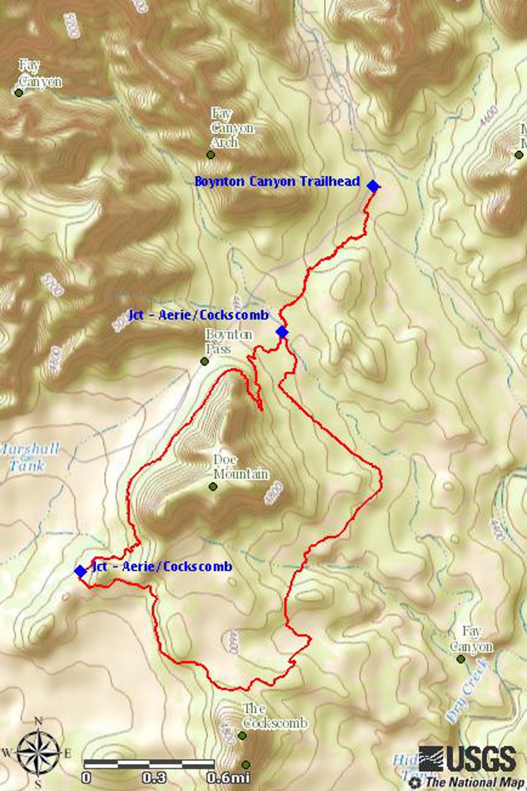
Our GPS track for this
hike is shown in red on the following map. The total hike distance
was 7.2 miles, the maximum elevation was 4728 feet and the total
ascent was 777 feet.
1
Price, Ellis F, At Sea & Ashore During Vietnam. Createspace,
2011, Print, Page 73
No comments:
Post a Comment