October
21, 2015 started out a bit on the chilly side, but the sun was
shining brightly, giving us hope for a pleasant hike to Devil's
Bridge. My last visit to the bridge had been in March of 2009.
However, I think some of the group hiked there in March of 2012 while
the rest of us climbed the west face of Capitol Butte, Thunder
Mountain if you prefer.
We
drove north from Cottonwood on Hwy 89A to Sedona and turned west on
Dry Creek Road, proceeding for 2.0 miles before turning right onto
Forest Road 152 (some maps label FR as 152 Vultee Arch Road; some
call it Dry Creek Road). In any case, after turning onto it, we
drove another 0.2 miles before turning left into a large, paved
parking area with toilet facilities. That means, of course, that you
must display a Red Rock Pass or a U. S. Forest Service Golden Age
Pass. The turn in is hard to miss because it is located just where
the pavement ends and a line of partially-embedded boulders bisects
the road ahead. If your vehicle can't cross the boulders, use the
parking area.
This
road has deteriorated significantly during the fifteen years I have
lived in the area. I am sure this is primarily due to lack of
funding but the resulting rough road must also be a favorable
development for the jeep tour companies located in Sedona. A lot of
their customers are surely tourists who would drive themselves if the
road were maintained. I myself do not hesitate to drive the road,
even as far as the Vultee Arch Trailhead where it ends, about 3.5
miles ahead. But I only do it in a 4-wheel drive, high-clearance
vehicle equipped with skid plates. Four-wheel drive and
high-clearance vehicles are, in my opinion, necessities; the skid
plates are added insurance.
The
upside of the non-maintained forest road is that a lot of work has
been put into improving and adding trails to provide access to the
area. For instance, whereas a few years ago one could drive up the
road and do a short, 1.8 mile, in-and-out hike to Devil's Bridge, we
would today park at the newly-developed parking lot and hike on
Chuckwagon Trail and a short connector trail to reach the Devil's
Bridge Trailhead. In this instance, it made for a 6.3 mile round
trip hike, just about right. On the other hand, to hike some of the
longer trails located farther up the road, one really does need
vehicle access.
We
donned our gear and gathered for a group photograph.
 |
Left to right: David Beach, Chris Jensen, Daisy Williams, Roger Fenske, Gary Jacobson, Iris Dobler, Lila Wright, Nita Nettleton, Dirk Knehr, Ellen McGinnis, Jim McGinnis, Robert Reed, MaryAnn Reed-Cook – author not shown
|
We
looked back over our shoulders to Lizard Head (below
left) outlined against the sky along the slope of
Capitol Butte and then fixed our eyes on the trail ahead (below
right).

Although
I had a GPS track for the trail we would follow, it was completely
unnecessary. The path was well-worn and clearly marked. We left the
parking area at the well marked trailhead and found ourselves
traveling along a lightly forested hillside, the vegetation
consisting primarily of juniper, scrub oak and manzanita. This light
growth was soon interrupted by a wide slick-rock area, mostly devoid
of vegetation, that formed the low point of a wash running down the
slope of Capitol Butte and emptying into Dry Creek. After crossing
this bare spot, the trail led us up a slight slope and into another
stretch of junipers, scrub oaks and manzanitas. Looking west from
this section of the trail we had a great panoramic view of the nearby
red rock formations and the Black Hills on the horizon. The black
hills can be seen stretching from the left to just past the middle of
the below photograph. The red mound in the center is Cockscomb, the
flat mountain behind the dead tree is Doe Mountain and the mountain
at right is Bear Mountain.
 |
| The Black Hills, Cockscomb, Doe Mountain and Bear Mountain |
After
crossing a gently-sloping ridge, the trail descended into the next
wash and the junipers and small shrubs gave way to Arizona cypress
trees. The first specimens we saw were a rather scrawny lot but, as
we moved deeper into the wash, the trees became larger.
The
trail runs generally parallel to and, at first, quite close to FR
152. But after about 0.8 miles it turns away from the forest road
before swinging back and crossing it to connect with the Devil's
Bridge Trailhead. One result is that the distance by trail is almost
a mile greater than by road. Recognizing this, the trail builders
provided a connector trail (below left)
here so that hikers can conveniently connect with the road if they
wish. We chose to continue on the trail and soon came to a unique,
laddered stretch of the trail (below right)
that had been carved by nature in the bottom of a wash.

As
we were crossing another juniper-covered ridge between sections of
the trail that were overhung with Arizona cypress trees, we came to a
second great viewpoint, from here we had a panoramic view into the
Secret Mountain Wilderness.
 |
| Secret Mountain Wilderness–Doe Mountain (left) to Little Round Mountain (right) |
We descended from the
ridge and, deep in the Arizona cypress forest and, just 2.2 miles
from the trailhead, came to the Devil's Bridge connector trail. The
connector begins at the sign pictured here (below
left) and ends at Forest Road 152, just across the
road from the Devil's Bridge Trailhead (below
right).

The
distance from FR 152 to Devils Bridge is only 0.9 miles. The first
part of that is along an old wagon road which is quiet steep in
places (below left). Then it
leaves the old road and becomes very steep (below
right).

Don't
be discouraged by the steep section of trail shown above. It is
short and, despite the fact that they don't show up very well in the
picture, there are steps to make the climbing easier.
In the below
photograph, seven of our hikers are shown standing on the bridge.
The trees shown in the background are on the other side of the
canyon. The scraggly little bush in the foreground is a manzanita.
 |
| Left to right: Jim McGinnis, Lila Wright, the author, Chris Jensen, MaryAnn Reed-Cook, Robert Reed and Dirk Knehr |
There
were a lot of hikers at the bridge, but they were quite orderly,
going onto the bridge one or two at a time, occasionally in larger
groups, to have their pictures taken by compatriots waiting on the
slope above. I chose a spot in the sun and photographed some of our
group as they ventured onto the arch of the bridge.

We
lingered for some time on the sunny rocks overlooking the bridge to
watch the hikers. Some just looked at the bridge from the slope,
some ventured tentatively out onto the arch as though they might be
the person under whom it collapsed and some strode confidently onto
the arch and turned walked on their hands or stood on their head to
show their lack of fear.
We
had delayed our midmorning snack until we arrived at the bridge
because Lila had told us the mountain behind us would shade the area
starting around 1100. As predicted, the sun retreated behind the
mountain and we stirred ourselves for the return hike. On our way
back, we moved smartly along until we found a sunny spot for lunch on
the other side of FR 152. Unfortunately, I had perspired enough by
then that my clothes were damp and a chill wind was blowing. I was
just too uncomfortable for my normal noon nap, barely closing my eyes
before being awakened by a cool gust of wind. I was ready to move on
and my trailmates readily agreed.
We
arrived back at the parking lot early enough that we decided to add a
short scouting hike to the itinerary for the day. We planned to hike
to Windmill Mountain next January and still had not determined just
what route we would take. We had noted, while looking at an
out-of-date map that an old road once ran toward the mountain,
leaving the highway somewhere between the Sedona Wastewater Treatment
Facility and the Dry Creek Bridge on Hwy 89A. We hoped to use that
road for part of our hike. We just needed to locate it and hike on
it far enough to find a good point from which to bushwhack our way to
the top of the mountain. We determined that the access to the old
road is now by way of the northernmost entrance to the wastewater
treatment facility. One just turns off Hwy 89A as though entering
the facility and then immediately turns right on a dirt frontage
road. We parked there and explored on foot, finding that the old
road, still marked as a forest road, will indeed lead us over half
way to the top of Windmill Mountain.
Today's
hike to Devil's Bridge and back turned out to be 6.3 miles. However,
it can be shortened to 5.3 miles by taking the connector located 0.8
miles along Chuckwagon Trail from the parking area and continuing on
FR 152. Additionally, one can drive on past the Forest Road 152
turnoff on Dry Creek Road to the stop sign, turn right on Long Canyon
Road (FR 152B) and continue 0.6 miles to the Chuckwagon Trail sign on
the right and shorten the hike to 4.3 mile. You will recognize the
start of this hike by a small parking area alongside the road.
Although it was marked as Chuckwagon Trail the last time I hiked it,
it might be called Lost Way or Mescal Trail or Mescal Bike Trail. I
have seen all three names on different maps.
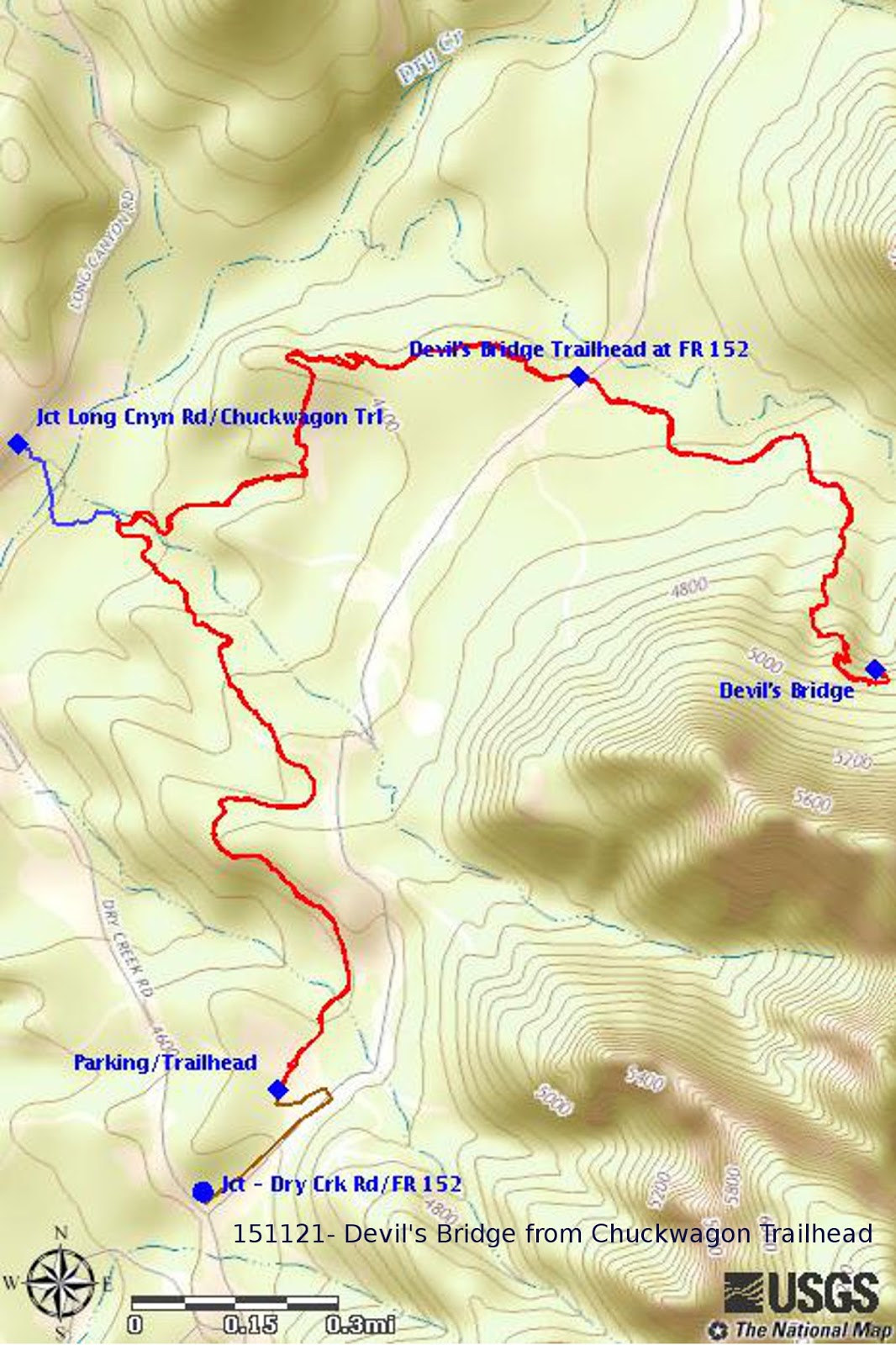
Our
GPS track for the 6.3 mile round trip hike we did today is shown in
red on the included map (below).
The highest elevation was 5009 feet and the total ascent was 1283
feet.
The
alternative section of trail, starting at Long Canyon Road and
resulting in a 4.3 mile hike, is shown by the blue track on the map.
This blog post very useful for our side because
ReplyDeleteAluminium Scaffolding Rental In Hyderabad