It
was a dreary day on 6 December 2014 when we set out to hike from
Lower Red Rock Loop Road near Elmerville to Horseshoe Bend at Oak
Creek. This was at least the third time I had hiked to the same
place on Oak Creek. I hiked in once along Lime Kiln Trail starting
from Red Rock State Park and turning off at the saddle through which
a riding trail leads down a steep rocky track to the creek at a sharp
curve that I call Horseshoe Bend. Although I don't think it has an
official name.
We
left Cottonwood at 0800, drove north on Hwy 89A, turned right onto
Lower Red Rock Loop Road and continued for another 1.2 miles to park
at a large horse trailer parking area at the trailhead.
The
Trail we were looking for was marked on my map as Elmerville Spur R,
a riding trail. However, we found it to be a dirt road signed as
Forest Forest Road 9845. A little distance down the road we did
finally see a riding trail sign, but it was Spur S instead of Spur R.
Then about 0.5 miles from the parking lot, Spur S turned sharply to
the left (east). Since the hike would otherwise be only around four
miles, I decided to be a little adventurous and follow Spur S to the
Lime Kiln Trail with which I knew it would intersect ahead. This
resulted in our making the dogleg to the east shown in blue below
from Spur S/Spur R to Spur S/Lime Kiln and back to Spur R Lime Kiln.
From there it was just 0.3 miles to the Spur A/Lime Kiln turnoff that
would lead us to the saddle above Horseshoe Bend on Oak Creek.
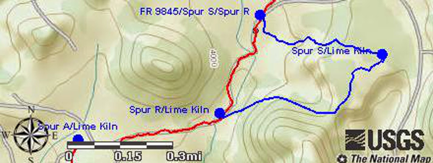 |
Map showing our circuitous route on the hike to Horseshoe Bend
|
Only
slightly delayed by my detour, we soon arrived at the saddle. There
we were faced with a steep, somewhat perilous 0.4 mile descent to Oak
Creek. Looking down the trail, several of our hikers decided it just
wasn't worth the effort and elected to climb a nearby knoll and enjoy
the view until the rest of us returned.
 The
descent, as we started down, did look rather scary (right)
but some of us had done it before and knew we could do it again.
The
descent, as we started down, did look rather scary (right)
but some of us had done it before and knew we could do it again.
We
had to make our way slowly to avoid stepping on a rolling rock or
loose gravel but we were shortly standing on a ledge overlooking the
bend in the creek. In the following photograph, the banks of the
creek are lined by sycamore trees, still clinging stubbornly to the
last leaves of the season, lining its bank.
 |
Sycamore trees lining the banks of Oak Creek
|
On
arrival at the creek we found a cozy camping spot with an existing
fire ring and a gaudy, out-of-place white plastic chair tucked close
against the red rock cliff on the creek bank. I wondered why anyone
would go to all the trouble of bringing such an out-of-place object
to this isolated place when chunks of driftwood and other naturally
occurring objects that would serve the same purpose were readily at
hand. Somewhat less objectionable to my mind was an ancient derelict
canoe, long past repair, nestled among the trees alongside the
stream.
 |
| Fire ring |
 |
Derelict canoe
|
Before
leaving the campsite, I took a last look at the peaceful views up and
down the stream. I thought that this would be an ideal spot to
spend time alone.
 |
Looking upstream from the campsite
|
 |
Looking downstream from the campsite
|
 |
Looking back to the hidden, isolated campsite
|
Before
starting our climb back to the gap where the other members of our
party were waiting, we paused for a view of the Indian ruin perched
in a fold of the red cliff on the northwest quarter of the bend. I
had already explored the ruin twice before and, truth be told, there
is not much to see anyway. We had found a few pottery shards, but
the structure itself is not very impressive, having apparently been
recently rebuilt by passing hikers.
 |
Indian ruins in a cliff northwest of the bend
|

Having no desire to
climb up to the ruins we turned our attention to the steep climb
(left) back to the saddle.
Strangely, the climb seemed less difficult than we had imagined it
would be. Still it was steep and precarious, requiring careful
attention to footing.
I
had lagged behind to take photographs and, as a result, reached the
saddle a few minutes behind the others. On arrival I found them all
grouped together for lunch, so I took a group photograph before
joining them.
 |
| Left to right: Mark Purcell, Jim Manning, Miriam Sterling, Marywave Van Deren, Leon Girdner, Joanne Hennings and Gary Jacobson – photograph by the author |
There
had been some disgruntlement about the circuitous route I had chosen
on the way in so I promised that we would take the shortest route
back. That would be easy because we now knew that Forest Road 9845
is also Spur S for part of its length and Spur R for the rest of the
way to Lime Kiln Trail. It runs directly from the parking area to
connect with Lime Kiln Trail just 0.3 miles from where we had left
that trail to turn onto Spur A. We had then followed it through the
saddle and down to the creek.
The
sun almost came out once on the way back. We did at least get a
brief glimpse of a small section of blue sky as we moved briskly
along FR 9845. But the clouds quickly closed in again.
The road we were
following had a few rough spots where a high clearance, 4-wheel drive
vehicle would be needed, it was otherwise in good condition.
 We
moved right along and made good time back our vehicles, making only
one brief stop to admire an especially attractive Christmas cactus
(right) located in a tree-shaded
spot alongside the road.
We
moved right along and made good time back our vehicles, making only
one brief stop to admire an especially attractive Christmas cactus
(right) located in a tree-shaded
spot alongside the road.
Our
total hike distance was 4.4 miles as shown on the included map (next
page). The red track shows our route for the return
hike while the blue track discloses the detour we took on the way in.
Without the detour, the hike would have been just 4 miles. The
maximum elevation was 4151 feet, the total ascent
was 615 feet and the total descent was 636 feet.

No comments:
Post a Comment