This report describes an April 2012 trip to Ireland with my daughter Diana.
Initially,
the trip was planned primarily as a hiking trip. Diana and I
intended to do a series of one-day hikes around the Dingle Peninsula
that would enable us to stay at bed and breakfasts along the way.
However, we soon decided to add visits to a few points of interest
and make some side trips for bird watching. We also looked at
the expected weather conditions in Ireland for the time of our trip
and decided that, neither of us being inclined to hike in the rain,
we would need to be flexible enough to substitute other activities
when conditions looked too bad. We later found that, at least
during the two weeks we were there, any local weather forecast that
did not include both rain and at least some period of sunshine was
just wrong.
Diana checked out the birding places and other points of interest, and I concentrated on identifying hikes that we might do and bed and breakfasts where we could stay. Everything would depend on the weather and also on what we felt like doing on any particular day.
We both made our reservations on United Airlines using the Military Officers Association of America travel service. We both flew to Newark (Diana from Washington, DC and I from Phoenix, AZ) to catch the same flight to Shannon, Ireland. The United web site allowed us to select adjacent aisle seats on the 6.5-hour flight to Shannon. We left Newark at 1730 on the 13th and arrived in Shannon at 0700 on the 14th. Seated near us on the plane was an Irish family (parents with two small, very well-behaved children) who were returning from vacation in the US and happened to live near Tralee where we intended to spend our first night. They gave us instructions on how to take the bus from the Shannon Airport to Tralee.
We were determined to avoid jet lag by remaining up until our normal bedtime that night and we had already decided to start our trip off with a hike from Tralee to Camp on the Dingle Way (a trail that runs all the way around the Dingle Peninsula), so we took the bus from Shannon to Tralee, changing in Limerick. On arrival in Tralee, we checked into the Grand Hotel on Denny Street and, finding the weather to be favorable and several hours of the day left, set out to see some of the town and locate the start of the Dingle Way.
 One of the first and most impressive sights we saw was St Johns Catholic Church (right) and we paused for a few minutes just to admire it.
The church was indeed nice and we could have spent more time checking it out, but we wanted to make sure we knew where to find the Dingle Way before we started out the next morning, so referring to the track I had drawn and loaded onto my GPS, we headed out to locate it. According to what I had been able to see on the map I was using, it should start at a place called Ashe Hall. Ashe Hall turned out to house the Kerry County Museum and we found a trail marker showing the start of Dingle Way at the pedestrian exit on the west side of the facility.
The day was pleasant and we had some time to kill so we decided to take the trail for a short distance to Blennerville and then return. This would take us along the river leading west into the bay where we could observe the birds in the area.
Leaving Ashe Hall, we followed the trail west down a small street for about 0.1 miles and then turned south on Highway R551 to connect with Highway N86 (the road to the village of Dingle) after another 0.2 miles. A roundabout with a fountain in the middle marks the intersection with the road to dingle.
The following picture was taken along R551 before we reached the roundabout at N86.
 |
Picture taken in Tralee on R551 approaching the intersection with N86
|
The trail followed N86 west for a short distance and then made a small jog to the right in order to follow along the opposite side of a canal that ran parallel with the road. My map showed the trail rejoining N86 a little over a mile ahead and we wanted to look at the birds in the marshlands along the river, so we continued along N86 to stay closer to the river. Diana is shown below pointing to the trail marker. The Dingle Way Trail runs between the canal and the apartment buildings shown to the right in the picture.
 |
Diana pointing to the trail marker
|
Beautiful pink cherry blossoms (Prunus serrulata, below left) and bright yellow flowers on Scotch Broom shrubs (Cytisus scoparius, below right), which grows extensively in hedgerows, lent color to the countryside along the way.
 |
| Pink cherry blossoms Scotch broom sedge |
 We passed an interesting thatched roof building (photograph by Diana right) located alongside N86 about halfway to Blennerville. It appeared to be used as some sort of office building; however, it might have been a residence.
Looking off to our left (south) across the river we could see streams running down through the marsh into the river (photograph by Diana below).
The light made it appear that ice had formed along the stream banks, but it was much too warm for that; it was just mud. Looking beyond the stream and across a level field, we could see a section of private property running up the mountain beyond (the green section). The upper right quadrant of the photograph shows what is apparently a part of the commons used by all the local farmers to pasture sheep.
 |
| Stream with hillside fields in the background |
We continued to the bridge at Blennerville and crossed over the canal to return by way of the Dingle Way Trail. We didn’t find a lot of exciting birds, but we did get in a good 3.5-mile walk. By the time we returned to the hotel and ate dinner we were ready for a good night’s sleep.
The next morning we awoke to a bright, sunny day and headed out for the hike to Camp with much anticipation. The first part of the hike just involved retracing the previous day’s walk to the Blennerville Bridge. We stopped where the trail leaves the parking lot at Ashe Hall (Kerry County Museum) to take photographs. Luckily, a friendly passerby was willing to take one of us together as we prepared to start our walk.
 |
Ellis and Diana on 15 April 2012 at Ashe Hall in Tralee, Ireland – photograph by a passerby
|
We stopped on the bridge for a view of the windmill at Blennerville (built in 1800) and to allow Diana to photograph birds.
 |
Photograph of the windmill at Blennerville - taken upstream from the bridge – by Diana
|
The trail followed N86 across the bridge but then immediately left it to follow a series of small streets and roads through the village and into the countryside. The fencerows were all ablaze with the bright yellow blossoms of Scotch Broom, occasionally interspersed with the beautiful pink of a flowering cherry.
The trail was easy to follow as long as one didn’t forget to watch for the turns indicated by the small yellow figure of a hiker above a directional arrow. Eventually, the trail left the road and we found ourselves passing through a bog. The bog is common land pastured by sheep with bright stripes of color painted on them to show ownership. It was located on the slope of a mountain range that runs from Tralee to Camp. We had the treeless mountains to our left and private fields below along the coast. The boggy hillside was terraced to channel water to specific drainage areas and avoid flooding the private fields. Our trail generally followed along these terraces. The photograph below shows the bogs (rather brownish landscape in the foreground) and the private fields along the shore below.
 |
Bogs shown in the foreground with private fields along the shore below
|
We pretty much had the trail to ourselves, meeting only one other couple along the way. They were from the local area and we paused to pump them for information. We learned that they called the Scotch Broom “furr,” a name I have been unable to verify anywhere else. They also noted the treeless mountains and attributed it to the British, saying ‘they cut all the timber and used it to build ships to send people to America.” The destruction of the forests by the British is a common complaint. However, Irish farmers apparently graze the mountains so intensely with sheep that no trees can get a start. I decided that they really prefer sheep to trees, but still resent the British for destroying the forests even though that is what made the grazing land available. About two thirds of the way through the bog, we came to a beautiful stream flowing down a deep gorge. Parts of the gorge were nearly inaccessible to sheep and trees had started growing in those areas. The river and gorge are shown in the below photograph.
 |
Stream (river) upstream of the Dingle Way crossing – note the trees growing along the steep bank
|
Immediately after we crossed the stream shown above, the trail became wetter and we often had to step carefully to avoid miring down in mud. The clouds had closed in and it began to look like rain. Additionally, we were both tired and getting a bit chilly, so we decided to cut down the mountainside and connect with N86 for the rest of our trip to Camp at the first opportunity. We did finally find a way down and followed the main road on to our destination. Walking along a main road in Ireland can be a hair-raising experience; there is often little or no shoulder room. They are careful to paint yellow lines on the outside of the road. Unfortunately, there is often no distance between the yellow line and a rock wall, meaning that a hiker is sharing the lane with oncoming traffic. Luckily, Ireland seems to be blessed with good drivers.
Even with the hazard of sharing a lane with traffic it was a relief to finally be off the bog, no longer having to slog through patches of mud. We took several short breaks at wide spots in the road and at one point watched farmhands herd cows across N86 from the lower fields to a milking barn on the upper side of the road. The next photograph (next page) shows the herd approaching the main highway.
 |
A herd of dairy cows approaching the milking barn
|
Having made advance reservations at the Finglas House Bed and Breakfast we were not worried about where we would stay for the night. However, when we finally arrived, we found that they were overbooked. The proprietress explained that her husband had taken our reservation while she was out. But, we were not to worry she said as she would make a reservation for us nearby and drive us to the alternate location.
Although we were both dead-tired and suffering from a touch of hypothermia by this time, we decided to go across the road and have dinner at Ashe’s Pub. They lead us to a side room that had no heating, at least not active heating, and there we sat shivering away while we waited for our food. We were the first customers in the room and thought at first that someone would have turned the heat on when we were seated. After all, it was nippy enough that a fire was burning in the main room. After a few minutes, I gave up and asked for heat. The waiter looked surprised that anyone would need heat in April, but thought about it for a few seconds and then relocated us to the main room where someone had vacated a choice table directly in front of the fireplace.
We managed to finish our meal and stumble back across the highway to the pub at Finglas House B&B for the ride to our alternate lodgings. When we got checked in, Diana took a hot shower while I had a hot tea. She then dived into her bed under all the covers she could find while I took a shower.
Seeing that she was still shivering when I finished my shower, I threw all of the spare towels over her and went to bed myself.
We both slept in until the very end of the breakfast period the next morning and were considering staying another day, as the weather had turned too bad for hiking anyway. But there is really little to do or see in Camp, so we walked back to the bus stop at Ashe’s Pub and caught the 1230 bus to Dingle. By the time we arrived there, visited the tourist office, decided on a hotel and checked in, the day was done. We ate at our lodgings, the Dingle Hotel, watched TV for a while and went to bed.
The next morning, it was again rainy and we visited the tourist office to check on boat tours that might be running. We particularly wanted to visit Greater Blasket Island, and they also ran a harbor tour called the “Fungie Tour” because a dolphin named Fungie always escorts the boat. We were told that Fungie has escorted the fishing boats in and out of the harbor for some twenty years. The seas were too rough for boat tours, but we found that a personal tour of the peninsula along Slea Head Drive past the landing for Blasket Island and on to Mt Brandon was available for a reasonable charge. We decided on that and were driven by Diarmuid Begley of the Diarmuid and Dorothy Begley Taxi and Shuttle Service.
Diarmuid turned out to be an excellent tour guide, providing information about the sights we saw, along with a running commentary on such recent events as visits by Queen Elizabeth and President Obama. He was hugely impressed by Obama’s ability to connect with the Irish people and was almost moved to tears by the Queen’s visit, the first by a British monarch since Irish independence in 1922. What impressed him most about the Queen’s visit was the fact that she laid a wreath at the Garden of Remembrance and bowed to honour those who died fighting the British for Irish freedom. He saw that as an apology for Britian’s actions.
The tour took us along the coast on Slea Head Drive (R559) with a side trip to visit the old Lord Ventry Manor House. Lord Ventry (Arthur William de Moleyns), apparently unable to pay the taxes, sold the 82,907-acre estate to the Land Commission and left the area in 1923. The lands were then transferred back to the tenants.1
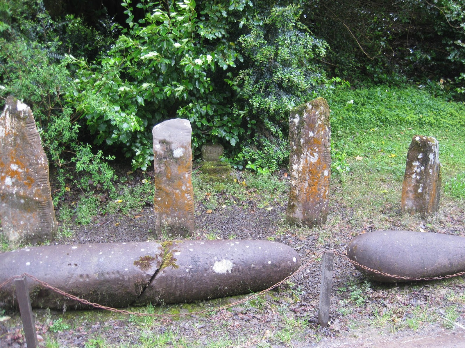 I did not get a picture of the manor house, now apparently used as a school; we just turned around in the driveway and departed. As we were leaving, I did get a shot of some ancient grave markers (right) placed alongside the drive-way. Our guide indicated that these had been moved here from elsewhere on the estate for safekeeping.
We stopped along the way to look at castle ruins located alongside the road in a pasture with grazing sheep. Diarmuid told us that the ruins were of a three-story residence used by an overseer on the Ventry Estate. These overseers were the people who collected rents from the tenants for the estate owner. I suppose the three-story “castles’ were to give them some added prestige as well as protect them from attack from disgruntled tenants.
 |
Rathanane Castle, Slea Head Drive, Dingle Peninsula, Ireland
|
Irish tradition associates the fairy forts (ringforts) and burial mounds with fairies and holds that those disturbing them are bound to suffer for it. Such beliefs are still to be found in Ireland today. As an example, according to a 22 November 2011 article in the Irish Independent, some claim that the removal of a tomb to a different location to make way for a quarry expansion caused the downfall (and bankruptcy) of Sean Quinn, a billionaire Irish developer.3
The ruins of some of the fairy forts (ringforts) built of stone are still clearly visible. Diana took the below photograph of ruins sitting atop the ocean cliff farther along Slea Head Drive.
 |
Fairy forts on the cliffs alongside Slea Head Drive – photograph by Diana
|
 |
Rough and stormy sea near the Blasket Island ferry landing at Dunquin
|
Diarmuid also pointed out various sites associated with the filming of Ryan’s Daughter,5 including the site of the village constructed for the movie and a beach that figured in the production. Dunquin villagers were used as extras and nearly a million pounds were spent in the area during the filming. This revived the local economy and lead to increased immigration to the Dingle Peninsula.
Some of my favorite sights along the way were the farmhouses and cottages, such as the below example partly hidden by a Scotch Broom hedgerow.
 |
Farmhouse partly hidden by a Scotch Broom hedgerow
|
The next day the seas had calmed down a bit and we took the harbor tour (also known as the Fungie tour). I managed to get a fairly decent shot of Fungie (the dolphin) when he came alongside to escort us toward the mouth of the harbor (picture below).
 |
Fungie the dolphin escorting us from the harbor
|
 | |
| View of birds, the shore and another boat from the harbor cruise boat – photograph by Diana |
 |
Boats along the quay with Dingle village as a background – photograph by Diana
|
 |
A view of houses along the shoreline with threatening clouds in the background.
|
The weather was still bad the next day with rain on and off all day long. We slept in, barely making it to the dining room before they quit serving breakfast. Diana took the Harbor tour again while I just lounged about and made a trip to the library to use the internet.
We would have to move from the Dingle Hotel today and were not decided as to whether we would go to another Dingle location or move on to Cork. Before making a decision, we stopped at the tourist office and found that the weather had cleared enough that the Blasket Island Ferry was running today, but that the forecast indicated that it would then have to shut down again for several days. We immediately had them book us a trip on the ferry, make reservations at a local bed and breakfast for another night in Dingle and arrange transportation to Dunquin where we could catch the ferry.
The Blasket Islands, consisting principally of Greater Blasket, Beginish, Inishnabro, Inishvickillane, Inishtooskert and Tearaght Island, were inhabited until 1953 by a completely Irish speaking population.6 They were then evacuated to the mainland, apparently because of the difficulty of delivering services to the islands. The ferry, operating primarily during the main tourist season, carries tourists to Greater Blasket, the larger of the group.
Some of the former inhabitants still live on the nearby mainland practically within sight of their old homes. The taxi that took us to Dunquin actually carried a former resident, a lady who was born on the island, from Dingle to her farm home on the way to Dunquin. Her first name was Naimh and she had migrated to America where she worked for Travelers Insurance company in Hartford, CT before returning to Ireland and marrying a farmer on the Dingle Peninsula near her birthplace.
When we arrived at the ferry landing we found that a long steep walkway ran from the parking area down the cliff to the actual landing. The picture below shows the ferry approaching the landing to pick us up. Note the dinghy being towed; it is used to transfer passengers between the ferry and the landing at Greater Blasket Island.
 |
Blasket Island Ferry approaching the landing at Dunquin with dinghy in tow
|
 |
Diana juryrigging a cover to protect her camera from the rain
|
 |
Loaded dinghy transporting passengers between the moored ferry and the landing
|
 |
Sheep on Greater Blasket Island Donkeys on Greater Blasket – by Diana
|
 |
Seal at Greater Blasket – by Diana Yes … the barbells work – by Diana
|
 |
| Fenced-off ruins on Greater Blasket Island |
From
our position high on the hillside we could see the moored ferry and
the dinghy returning a load of passengers to it. The small
island seen above the ferry is Beginish, the smallest member of the
Blaskets.
 |
Passengers being transported out to the moored ferry
|
On the return trip Diana rode on the fantail; note the dinghy riding the waves behind us. The winds were picking up and we caught the last ferry back.
 |
Diana riding back from the island on the fantail of the ferry
|
 |
View of the cliff as seen from the walkway leading from the Blasket Island ferry landing
|
 After breakfast the next morning, we left our laundry at the local “service wash” place in plenty of time to get it back that afternoon and headed out for the livestock auction. While walking up Green Street near Saint Mary’s Church we heard an awful commotion that turned out to be a magpie fight on the grounds of the Diseart Cultural Center (left).
When the magpies had settled their disagreement, we continued on to the auction barn. Young calves are being auctioned in the picture below. Today was the 21st of April and, as can be seen in the board shown in the picture (see upper right), they were not quite four weeks old.
 |
Livestock
auction at Dingle, Ireland
|
It was Sunday morning, 22 April when we caught the bus to Cork. To get to Cork, we first had to take a bus back to Tralee where we had started our travels a week ago. We changed buses in Tralee and continued on to Cork. We really didn’t have any firm plans for Cork, but it looked like a good place to visit and the weather was still not suitable for hiking. Even if it did clear up enough that we felt comfortable hitting the trail again, just about any place in Ireland would provide an opportunity.
Another good reason for taking a bus just about anywhere in Ireland is to enjoy the scenery along the way. I never tired of gazing out the bus window and watching the green pastures dotted with sheep, cows and horses slide by. I also noted that we passed occasional stands of timber. Ireland apparently has a reforestation program that subsidizes farmers for growing trees, this according to Diarmuid Begley our tour guide for the Slea Head Drive tour.
 We arrived in Cork early enough to look around before checking into the Imperial Hotel where we were staying that night. We strolled along the River Lee and then spotted St. Finn Barre Catherdral (sign at right). Upon approaching, we found that it was open for visitors; they even had someone playing the organ. We learned that the cathedral was designed by William Burgess, a follower of thirteenth century French Gothic architecture.
 |
St. Finn Barre’s Cathedral
|
 |
Legend of carvings displayed on the front of the cathedral
|
The next morning we ate breakfast with a very friendly lady from Galway. She was studying Art Therapy and traveled to Cork two days per week for classes. After breakfast we looked around the local area, visited the local post office to mail packages home and caught the bus to Doolin. Arriving near the end of the day, we checked into Cullinan’s Guest House where the tourist office had made reservations for us.
 |
Cullinan’s Guest House – our lodgings in Doolen
|
After a good night’s sleep, we ate a quick breakfast the next morning, left our dirty laundry to be washed and headed to the boat landing. The landlady told us that she could hike it in 25 minutes if she hurried, and that is about how long it took us. However, when we arrived we found that the ferry would be leaving half an hour later than the time they had given us ... they just wanted to make sure we were there on time. We got a handy tourist to take a picture of us together.
 |
Diana and Ellis ready to board the Aran Islands Ferry
|
 |
The Aran Island Ferry arriving to pick up passengers.
|
 |
Approaching the landing at Inis Oirr
|
Immediately after leaving the pier we stopped at a small mound that Oliver said was a burial place that showed human habitation as early as 1000 BC. I later read the plaque posted by the authorities and found that a better estimate was 1500 BC.
 |
Burial mound on Inis Oirr dating to 1500 BC
|
 |
Plaque posted at the burial mound shown shown above
|
Some additional information on this subject can be found at Wikipedia.com.7 A sample of the information available is provided below.
The islands were first populated in larger numbers probably at the time of the Cromwellian conquest of Ireland in the mid 17th century, when the Catholic population of Ireland had the choice of going "to hell or to Connacht”. Many fled to the numerous islands off the west coast of Ireland where they adapted themselves to the raw climatic conditions, developing a survival system of total self-sufficiency. Their methods included mixing layers of sand and seaweed on top of rocks to create fertile soil, a technique used to grow potatoes and other vegetables. The same seaweed method also provided grazing grass within stone-wall enclosures for cattle and sheep, which in turn provided wool and yarn to make hand-woven trousers, skirts and jackets, hand-knitted sweaters, shawls, caps, and hide shoes.8
The below photograph shows an example of these small fields.
 |
Cows pastured in fields built up of seaweed and sand – photograph by Diana
|
We came next to a rusty old wrecked ship. On March 8, 1960, the M.V Plassy, “while sailing through Galway Bay carrying a cargo of whiskey, stained glass, and yarn … was caught in a severe storm and ran onto Finnis Rock, Inisheer, Aran Islands. The crew of 11 were safely taken off with the assistance of local islanders using a breeches buoy 9 fired by rocket. Several weeks later a second storm washed the ship off the rock and drove her ashore on the island.10”
Fifty-two years later the Plassy still sits there, now a popular tourist attraction.
 |
Wreck of the M.V. Plassy – photograph by Diana
|
The following photograph shows the castle; the signal tower discussed in the above article is on the other side of the castle and not visible from this angle.
 |
O’Briens Castle at Innis Oirr
|
 |
Looking across the fields of Innis Oirr from the castle grounds
|
 |
Looking down on the island cemetery from the castle grounds
|
Christianity came to the islands before the end of the first millennium. Near the swimming beach next to the ferry pier is the island’s graveyard. Here one finds the buried church called Teampall Chaomhain (“St. Caomhan’s church”). This is a 10th Century church said to have been founded by St. Caomhan (“Kevin”), a disciple of St. Enda the Patron Saint of the Aran Islands. (This St. Kevin is said to be the older brother of the St. Kevin who founded the monastic community at Glendalough.) The church was nearly buried by drifting sands, but has now been excavated and is kept clear of sand by the residents. It is a beautiful and peaceful place looking out over the ocean. [See http://thefunstons.com/?p=541]
A sign (below left) posted at the church ruin provides some historical data, and the ruin itself is entirely surrounded by grave markers (below right) dating from the very ancient to quite recent.
The ruins of Saint Caomhan’s Church are shown below.
 |
| Historical data Grave markers surrounding church |
 |
Showing the ruins of Saint Caomhan’s Church
|
 Leaving the church ruins we returned to the landing area in time for lunch. After that we decided to explore the beach area. Diana looked for birds on a small sandy area of beach while I examined the sea-weed growing on the solid rock (right) that made up most of the shoreline. Some of the seaweed was a bright green that looked very much like hair covering the rocks.
A section of the small, sandy beach surrounded by the bright green of the seaweed-covered rocks is shown below.
Our time on Innis Oirr was soon up and we boarded Tranquility for the return trip.
 |
Seaweed-covered rocks, sandy beach (our ferry – the Tranquility – is also visible, upper right)
|
Our fellow passengers were mainly German tourists, and a rude and pushy bunch they were. When we reboarded one German lady(?) planted herself at the foot of the gangway and loudly insisted that everyone else wait until she rounded up the other seven members of her group.
Several of the passengers had also signed up for a cruise along the Cliffs of Moher and we would stay on the boat for that cruise when it returned to the landing. Others had just booked for the trip to Aran and would disembark. Diana and I had managed to snag seats topside in an area where the view was unobstructed by the ships superstructure. When we arrived back at the pier, we moved from our seats to allow a German woman seated inboard of us to disembark. After getting out of her seat, the woman decided that she didn’t need to disembark after all and returned to her seat. Diana and I then attempted to reclaim our seats only to find a large German woman climbing over the back, from a row of seats that did not have a good view, to claim our seats for herself and her companion. I quickly placed my body so as to obstruct her and I am afraid that I told her very loudly to back off. She settled back in her own seat and sulked for the entire cruise along the cliffs. We had been told that the German tourists were not well liked, but did not realize why until this experience.
The cruise along the Cliffs of Moher was well worthwhile; we both enjoyed watching the birds soaring along the cliffs and seeing the hundreds perched on ledges on the cliff walls. The below picture provides a striking example.
 |
| Close up of birds perched on a rocky spire (seastack) that stands apart from the cliff proper – by Diana |
 |
Spire(seastack) standing apart from the cliff – also note O’Brien’s Tower atop the cliff
|
 |
Threatening weather was closing in – by Diana
|
The next morning we arranged to stay at the guest house for another night and set out right after breakfast for our hike along the cliffs. We started out at a good clip, hiking at first along the main road, then taking a dirt/grass farm road and then a newly-constructed trail that followed closely along the rim of the cliff before, finally, connection with the main road between Doolin and the Cliffs of Mohair Visitors Center. The following pictures were taken along the way.
 |
Diana passing Sea View B&B Looking over the cliff to the sea below |
 |
Looking ahead to O’Brien’s Tower – located on top of the farthermost promontory
|
 |
O’Brien’s Tower from the visitor center – a closer view
|
It was now the 25th of April and we were scheduled to fly out of Shannon Airport at 0900 on the 28th. We decided to spend one night and part of the next day in Limerick, then spend the last night at the Park Inn at the Shannon Airport, conveniently located just across the parking lot from the terminal.
On the 26th, we spent a leisurely morning at the guest house, walked across the road to eat lunch at the pub and then waited alongside the road for the 1230 bus to Limerick. We had reservations at the Boutique Hotel in Limerick and didn’t need to worry about a place to stay, so on arrival we stretched our legs by doing some sightseeing. We walked through a Georgian Garden and passed a Georgian House to visit the Frank McCourt (author of Angela’s Ashes, a 1996 memoir) Museum. When we arrived at the museum, we found Billy Campbell, a childhood friend of McCourt’s, there for a tour with his granddaughters. In Angela’s Ashes, McCourt skipped his Irish dance lessons and used the money to attend movies with Billy.
 |
Ellis and Diana with Billy Campbell at the Frank McCourt Museum in Limerick
|
The next morning, we ate breakfast, checked out and went on a walking tour of the city. We crossed the River Shannon at Shannon Bridge, walked along the river on the strand and crossed back over on Thomond Bridge at King John’s Castle. We then walked to the MilkMarket (a farmer’s market) for lunch before catching the bus to Shannon Airport.
The picture below shows a view looking across River Shannon to King John’s Castle on the other side.
 |
Looking across River Shannon to King John’s Castle in Limerick.
|
The next morning we walked across the parking lot to find the terminal locked down, apparently due to a tripped fire alarm. We walked back over to the hotel and printed our boarding passes to give us a head start on checking in when the terminal opened again. By the time we had done that, the lock down was over and we proceeded to check in.
Our Ireland Vacation was over and we were ready to go home.
No comments:
Post a Comment