Our
daughter, Diana, was visiting for a few days and had mapped out a
rather extensive list of things to do while here. Diana and I have
made several trips (Ireland, Wales, England and Scotland) together
during the past few years and have learned to ignore lists when it
suits us. So it was that we canceled a planned hike on Monday in
favor of a more relaxing day of just visiting, working a jigsaw
puzzle (Rosemary and Diana), reviewing preparations for the
forthcoming Price family reunion (Diana and I) and finishing a report
for the last Skyliner's hike (me). Then, Rosemary having called and
made reservations for us, Diana and I took a train ride up the Verde
River Canyon on Tuesday, 19 April 2016.
Rosemary,
who was attending to some duties involving a book sale at the
library, went to the station to see us off. A kind passerby used my
camera to take a photograph (below)
of the three of us as Diana and I prepared to board the train.
 |
| Left to right: Ellis, Rosemary and Diana Price |
Apparently
the passenger cars are all named for Arizona towns and cities. At
least, in addition to the Cottonwood Car on which Diana and I rode, I
saw several others named for Arizona cities and none otherwise named.
A
short history of the origin and a description of the current status
of the Verde Canyon Railroad are available on Wikipedia:
The
tracks on which the Verde Canyon Railroad runs were opened in 1912 as
part of a north–south branch line linking a copper smelter at
Clarkdale and the copper mines at Jerome to Santa Fe Railway tracks
passing through Drake. The Santa Fe Railway owned and operated the
38-mile (61 km) branch line from 1912 to 1988.
David
L. Durbano bought the branch line in 1988.
Passenger service between Clarkdale at milepost 38 and
Perkinsville at milepost 18, resumed in 1990 under the name Verde
Canyon Railroad. Milepost 0 of the AZCR is at Drake, where the line
meets the BNSF Railway system. The AZCR track to Drake is still used
for hauling freight even though the excursion line stops at
Perkinsville.
Excursions
involve a 4-hour, 40-mile (64 km) round trip from Clarkdale to
Perkinsville and back. Scenes from How the West Was Won were filmed
at Perkinsville in the 1960s. The route follows the Verde River,
crossing bridges and trestles, and passes through a 680-foot-long
(210 m) curved Tunnel. Between milepost 30 and Perkinsville, most of
the land along the railroad right-of-way is in the Prescott National
Forest or the Coconino National Forest (across the river).
The
railroad carries about 100,000 passengers per year. In 2005 the
Verde Canyon Railroad celebrated its one-millionth passenger, and the
following month was named an "Arizona Treasure" by Arizona
Governor Janet Napolitano.1
 As
the train pulled out from the station it passed close by the old slag
pile left over from the United Verde Copper Company Smelter which
operated here from 1915 to 1950. The Photograph (right)
provides a close up view of the slag pile from the train window.
Note the overhanging railcar roof in the upper left corner. The
horizontal grooves in the slag wall were apparently caused by a
corr-ugated holding barrier that kept the molten slag away from the
tracks until it cooled and solidified. Rusted remains of the old
metal barrier can be seen at bottom right in the photograph.
As
the train pulled out from the station it passed close by the old slag
pile left over from the United Verde Copper Company Smelter which
operated here from 1915 to 1950. The Photograph (right)
provides a close up view of the slag pile from the train window.
Note the overhanging railcar roof in the upper left corner. The
horizontal grooves in the slag wall were apparently caused by a
corr-ugated holding barrier that kept the molten slag away from the
tracks until it cooled and solidified. Rusted remains of the old
metal barrier can be seen at bottom right in the photograph. One
of the attractions of riding the Verde Canyon Railroad is the chance
to observe bald eagles. Apparently, the eagles have become
accustomed to the regularly-passing trains and do not consider them a
threat. In any event they build nests quite close to the railway and
an eaglet was hatched earlier this year; unfortunately, it fell
victim to a predator before leaving the nest. A photograph (left),
taken in 2009, shows a long-since abandoned nest built close to the
track.
One
of the attractions of riding the Verde Canyon Railroad is the chance
to observe bald eagles. Apparently, the eagles have become
accustomed to the regularly-passing trains and do not consider them a
threat. In any event they build nests quite close to the railway and
an eaglet was hatched earlier this year; unfortunately, it fell
victim to a predator before leaving the nest. A photograph (left),
taken in 2009, shows a long-since abandoned nest built close to the
track.
We
also passed the still-standing stack of the The Arizona Power Company
(TAPCO) Power Plant (below). The
TAPCO power plant was constructed by Arizona Power Company during a
seven-month period in 1917 and placed into service that same year.
It operated under base load from 1917 until 1930 and then
sporadically thereafter until sometime in 1958. The plant was sited
here primarily to provide power to the United Verde Copper Company.
 |
Ruins of the TAPCO Power Plant
|
The
next point of interest was the SOB Bridge, located about 4.5 miles
from the station, which carries the track across the 175-foot deep
SOB Canyon. According to our guide, SOB stands for Superintendent of
Bridges. Personally, I would have liked some explanation as to why
it was so named; was a specific Superintendent of Bridges being
honored? If so why didn't they just use his name? Was it intended
to honor the position of Superintendent of Bridges? Without some
further explanation it simply doesn't make sense. Perhaps the SOB
was applied by the workers who built the bridge to describe their
feelings about the task and the name just stuck. Alternatively,
according to Phoenix Magazine, “one popular
legend attributes the canyon’s name to a river pilot, Bill Diamond,
aka 'Sweet Ol’ Bill.'”2
Whatever
the origin of its name, we would soon be crossing it; already we
could see the bridge from the window of
our railcar. In the photograph (below),
the engine of our train is shown at left and the bridge can be seen
just right of center.
 |
Train approaching SOB Bridge
|
The
train is a popular venue for weddings and wedding vow renewal
ceremonies, with vows taken while the train is stopped on the bridge.
Weddingbee.com3
says, “Most ... ceremonies take place on an adjoining open-air
viewing car stopped over a historic trestle and steep canyon at a
panoramic overlook....” This could only refer to SOB Bridge;
the trains all stop on the bridge for passengers to take in the
views, exemplified by the photograph (below).
 |
View from an open car stopped on SOB Bridge
|
The
above photograph, which shows the downriver view from the bridge,
includes a view of Mingus Mountain on the far horizon. Closer up, in
the lower right corner, can be seen a colorful ocotillo cactus.
Looking
ahead, as shown in the photograph (below),
we could see the channel the river has cut into the surrounding
plain, the looming, red-tinted slope of Black Mountain to the right
and, to the left, the jumble of hills through which the Verde River
Canyon runs.
 |
| Looking ahead as the train travels across the plain toward the mountains ahead |
Continuing
our way up the canyon, we soon passed the confluence of Sycamore
Creek and the Verde River. This is the site where Packard Ranch was
located. The ranch was homesteaded in the 1890s by a Mr. and Mrs.
Packard who grew fresh vegetables on 35 acres of irrigated land. It
is reported that Mr. Packard had a wandering eye and that Mrs.
Packard, tiring of his philandering, “forged his name on a
quit-claim dead for $1800, bought two horses and a rifle and
disappeared to places unknown.”4
The
ranch holdings are now a part of the National Forest. The Trust for
Public Lands5
reports that, “Packard Ranch’s
protection was critical to the health of two perennially-running
waterways, rarities in Arizona where clean, safe drinking water is
one of the State’s gravest worries. In January 2012, TPL
transferred ownership of all 139 acres to the National Forest.”
There
is still a strip of private land located at the Sycamore Creek
junction and running upstream along the river. Further upstream of
the private land is located the Alvarez Ranch. The ranch, a long
narrow strip of land on the north side of the river, was acquired by
Rosendo Alvarez in 1908. The ranch was vacated in 1993 after a
devastating flood and became a part of the National Forest in 1995.
Referring to the photograph (below),
the ranch property was located between the nearby trees and the hills
beyond them.
 |
| Location of the Alvarez Ranch |
I
visited the old ranch site in May of 2014 and took several
photographs. Included were the old ranchhouse (below
left), taken while standing in the
middle of the river, and a nearby well (below
right).
 |
| Alvarez Ranchhouse Well at Alvarez Ranch |
We
found several other intact buildings as well as a productive
pomegranate tree at the site during this visit.
 A
short distance beyond Alvarez Ranch the canyon loops sharply north,
even sightly north-northeast and then southwest as it looped around
Mormon Pocket. We camped at Mormon Pocket while on an overnight
hike down the canyon on 24 May 2014. We found a very nice wooded
area, tucked tight against the cliff wall, just across the river from
the railroad. This photograph (right)
taken on the current trip shows the the cliff at the approximate
position of our campsite.
A
short distance beyond Alvarez Ranch the canyon loops sharply north,
even sightly north-northeast and then southwest as it looped around
Mormon Pocket. We camped at Mormon Pocket while on an overnight
hike down the canyon on 24 May 2014. We found a very nice wooded
area, tucked tight against the cliff wall, just across the river from
the railroad. This photograph (right)
taken on the current trip shows the the cliff at the approximate
position of our campsite.
As
we continued on up the canyon toward Perkinsville, the cliff walls
seemed to become ever closer and higher. We could now look almost
directly down into the river below where we saw turtles sunning
themselves on the rocks.
Shortly
before we reached the tunnel, just over four miles downstream from
Perkinsville, we reached another bald eagle nest. It was located
high above us on a ledge in the side of a towering rock spire. I got
a pretty good photograph of the spire (below
Left). Diana, meanwhile, zoomed in
for a shot of the nest itself (below
right).
 |
| Tall rock spire with Close up of eagles nest eagles nest |

After
passing the eagle nesting area we entered the 680-foot long curved
tunnel that carries the railroad through a high ridge with sheer
slopes at a sharp bend in the river. Shortly thereafter we were at
Perkinsville. Little is left at the Perkinsville stop except for the
long-abandoned old train depot and a few other decrepit buildings.
The old depot (left)
was used for shooting a scene in the 1962 movie, How
the West Was Won. In that scene, Zeb Rawlins (George Peppard)
and his wife Julie (Carolyn Jones), along with their two children,
meet his aunt Lilith Prescott (Debbie Reynolds) at the “Gold City “
Train Depot. As filmed, the portico shown here was extended for
several feet to the edge of a wide boardwalk that ran along the front
of the depot and a since-demolished extension to the building. The
flooring beams, as shown in the photograph, for the extension and the
boardwalk are still in place.
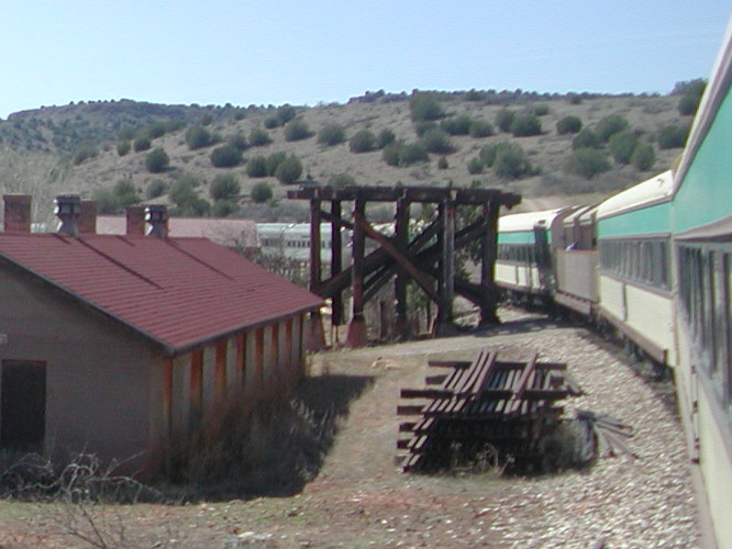 The
timber structure (right), shown
just beyond the red-roofed building, was photographed in 2009. It
once supported the old water tower tank used for steam locomotives.
The tank itself, out of use since the demise of steam locomotives in
the 1950s, was blown up for a scene in the movie; but that scene was
cut from the film.
The
timber structure (right), shown
just beyond the red-roofed building, was photographed in 2009. It
once supported the old water tower tank used for steam locomotives.
The tank itself, out of use since the demise of steam locomotives in
the 1950s, was blown up for a scene in the movie; but that scene was
cut from the film. The depot and and the
water tank foundation are located on the south side of the tracks.
The photograph (left),
taken looking north, shows the remains of a limestone quarry and kiln
used to produce lime for use as a flux at the Clarkdale Copper
Smelter until it closed in the 1950s.
The depot and and the
water tank foundation are located on the south side of the tracks.
The photograph (left),
taken looking north, shows the remains of a limestone quarry and kiln
used to produce lime for use as a flux at the Clarkdale Copper
Smelter until it closed in the 1950s. The train stops for ten
minutes at Perkinsville, just long enough for the engine to use the
siding to move to the other end of the train for the return trip.
The train itself does not turn around, the engine just moves to the
other end. The engine is shown here (right)
moving along on the siding for the change of direction.
The train stops for ten
minutes at Perkinsville, just long enough for the engine to use the
siding to move to the other end of the train for the return trip.
The train itself does not turn around, the engine just moves to the
other end. The engine is shown here (right)
moving along on the siding for the change of direction.
Perkinsville is located
in a relatively flat, roughly boomerang-shaped area, roughly 1.5
miles long and no more than 0.5 miles wide, along the river. Once
the engine was reattached to the train we started our return journey,
leaving the flat area around Perkinsville and, at Orchard Draw,
plunging once again into the narrow canyon.
 |
| Reentering the canyon at Orchard Draw |
Shortly we entered the
curved 680-foot tunnel, with walls sometimes only inches from the
cars (below left),
and were plunged into complete darkness. However, we soon reemerged
at the other end (below right)
and continued our journey down the lush canyon, now seen in a
different light than on the way up because of the angle of the sun.
 |
| Entering the tunnel Reemerging from the tunnel |
 |
| Warped and weathered canyon wall with weird shapes on top |
We were back at the
station in Clarkdale by 1638 after a most satisfying train ride up
the Verde River Canyon to Perkinsville and back.
NOTE: Be sure to review Footnote 4 below. It provides a lot of interesting information about the canyon, the railroad, the mines and smelter and the Packard, Alvarez and Perkins families.
1
https://en.wikipedia.org/wiki/Verde_Canyon_Railroad
2
http://www.phoenixmag.com/
3
http://www.weddingbee.com/wedding-vendor/verde-canyon-railroad
No comments:
Post a Comment