Sunday, November 25, 2012

Horton Creek-Derrick Loop


The Skyliners made two October 2012 hikes in the Horton Creek area. Both hikes are included in this report. The first, on the thirteenth, was reported by Lila Wright and collated by Ellis Price:

Nine Skyliners left Cottonwood at 0700 am, drove 93 miles to arrive at the trailhead at 0915 am. As we drove past Payson on Hwy. 260 we entered construction about a mile before our turnoff. We knew we were past our turnoff when we reached mp 269, so we turned around and could see our signs for Tonto Creek Recreational area and FR 289 on the way back. At this time of the year, the campground was closed but the trailhead parking lot was busy and quickly filling up.

From the parking lot, we walked back over the bridge spanning Tonto Creek and into the closed campground and trailhead. A very informative, color-coded sign was posted at the trailhead, showing the hiking trails in the Horton Springs area.

Color-coded sigh showing hiking trails – photograph by Lila Wright
Attached to one of the support posts for the sign on the previous page was a bear sign, reminding us that there had been an injury to a camper in the Payson area this summer. (photograph at right by Lila Wright).

Another sign gave us distances to the Highline trail and Horton Spring, our destination.

The first part of our hike was often through high grass that looked delicious for elk and deer. (photo)

High grass along the trail – photograph by Lila Wright
A great deal of the trail was over a badly eroded, rock strewn, old road bed. A tarantula crossed our rocky path (photograph at left by Lila Wright).

Once in a while, the trail veered away from Horton Creek but most of the time we could hear and often see the creek with its waterfalls and rapids.


Small waterfall on Horton Creek – photograph by Lila Wright
We had strict orders to look for and photograph a particular large, alligator juniper about half way to the spring. Going up the trail we thought we spotted it but discussed the fact that it did not seem bigger or more interesting than many others we had seen on other hikes in various places. Since we did not see any other large alligator junipers the rest of the way, we dutifully measured it on the way back down. It had a circumference of 4 1/2 arm spans. We also measured it with flagging tape and it was 16'10" when stretched out at home alongside a measuring tape. The hiking book we referred to said it was 19' so we either did not find the correct tree or missed a bump or two around the tree.
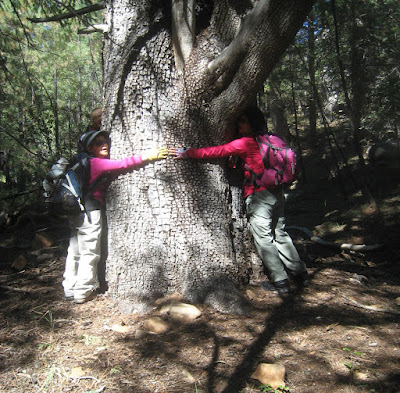
Old Alligator Juniper – photograph by Lila Wright
Our trail came to the Highline trail and we walked about 200 yards in an easterly direction on the Highline trail to our lunch spot right on the bank of Horton Creek. After lunch we posed for several group photos so hopefully the best is shown here. Our patient, unidentified photographer had lots of advice from us and another group of women hikers who were also enjoying the spot.

Left to right from rear: Lila Wright, Donna Davis and Donna Goodman 
(three abreast); Kwi Johnson and Miriam Sterling (two abreast); 
Betty Wolters, Daisy Williams and Dolly Yapp (single file, rear to front) 
– photograph by an unidentified hiker using Lila's camera
The actual spring gushed out of the boulders about 100 yards up a steep hill from our lunch spot.

Horton Spring – photograph by Lila Wright
The maple trees were just getting a tiny hint of autumn color and no other autumn colors showed except the brilliant red of the Virginia Creeper vine that twined up several trees along the lower portion of the trail. (see photograph by Lila Wright, below) Last night the temperatures were the lowest so far this fall and soon the fall colors will be beautiful on this hike. On our drive up, we noticed the San Francisco Peaks were covered with snow from the storm we had just the day before.

In 1990, the Dude fire destroyed many acres and Zane Grey's historical cabin about 3 miles west of this trail. Zane Grey often liked to hike the Horton trail to hunt elk and deer.

We ate an early dinner at "Tiny's Restaurant" in Payson and arrived back in Cottonwood a full 12 hours after we started. We were glad not to drive back through elk country in the twilight or dark.

Virginia creeper on trees and the very beginning of fall colors 
– photograph by Lila Wright
Becky Fowsky and Ellis Price, both having missed the 13 October hike, decided to schedule another hike in the same area. This time, however, instead of just hiking the length of the Horton Creek Trail and returning the same way, we would do the entire Horton-Derrick Loop. This would entail hiking up Horton Creek Trail, taking Highline Trail to connect with Derrick Trail and returning to Upper Tonto Creek Campground where the Horton Creek Trail started.

Becky Fowsky, Gary Jacobson, Diane Luce and the author left Cottonwood at 0700 on 25 October 2012 and drove straight through to the parking area located just across Tonto Creek from the campground. Frank Fowsky went with us but spent the day investigating Payson rather than hiking. We asked him to find a good place for us to eat dinner after our hike, and he come back with a recommendation for Tiny's Restaurant, the same place the hikers ate on the thirteenth. Like them, we found it to be an excellent, inexpensive choice.

From the parking lot we repeated the hike up Horton Creek already reported above by Lila Wright, seeing basically the same sights along the way.

When we arrived at Horton Spring, however, we crossed the creek just below the spring, using a makeshift bridge that had been constructed by placing several poles together across the stream. The bridge was a little shaky, but we all made it across without getting our feet wet.

Based on the rough-drawn map posted at the Trailhead we had expected the hiking distance on Highline Trail to be relatively short. What we found was that, of the 5.1 miles from where we crossed the creek to the parking lot, 2.9 miles was on Highline and only 2.2 was on Derrick Trail (all distances as measured by my GPS).

The Highline Trail is a National Recreational Trail and has diamond-shaped markers affixed to trees along the way that make it easy to tell that you are still on it.

It was close to lunchtime when we crossed Horton Creek on our way back, and we were alert for a good place to stop. As luck would have it, we came upon the below-pictured meadow just a few minutes past 1200.

Meadow along Highline Trail – our lunch spot
The return hike turned out be much harder than the Horton Creek Trail had been. The Highline Trail, although a good trail, was quite steep at times as it made its way across the ridges running down from the Mogollon Rim just above us. An alleviating factor was that it ran mostly through heavily-forested terrain that provided shade on this still warm fall day. It also provided some good views through breaks in the tree cover along the way.

The below photograph, taken just below Promontory Point, shows the view looking back toward Payson. Barely visible behind the dead tree to the left is the four-lane section of Hwy 260 running down the mountain to the turnoff for Upper Tonto Creek Campground where we were parked.

Looking toward Payson from the Highline Trail below Promontory Point
Eventually, the trail dropped down and, leaving the ponderosa pines behind, entered an area of smaller trees, primarily junipers.

The trail also became less steep but a little rockier. Although we were now out in the open, the hottest part of the day had passed and it was, after all, an autumn day. We perspired a little but remained quite comfortable.

As we approached and then traveled alongside an old fence, the surface of the trail became less regular and we found ourselves being careful to avoid stepping on loose rock.

A moderately rocky section of the Highline Trail
When we reached the Derrick Trail (right) and turned down it toward our final destination, the trail became much rockier, every step being on loose rock. The trail ran straight down the slope and, although the slope was moderate, unimpeded runoff had washed away all the dirt in the trail, leaving just the loose rocks. It was very much like walking in a rocky streambed. This continued for the better part of a mile before the trail leveled out a bit and entered another stand of ponderosa pines. It was still rocky, but by using a little caution, we could find dirt to step on between the rocks.

We also saw signs of recent work to ditch water away from the trail and minimize erosion. A little later, I noted a flash of color among the trees and, upon investigating, discovered a small mobile, hydraulically-operated “ditch witch” type machine (left). It must greatly facilitate trail repairs.

Continuing on through the pines, we soon came to our destination. The Derrick Trailhead is located just a few yards from the Horton Creek Trailhead. From there we retraced our steps out of the campground and across the one-lane bridge to the parking lot on the other side of Tonto Creek.

The Horton Creek Trail to its end at the Highline Trail is just over three miles long. The distance on Highline to the Horton Creek crossing is 0.4 miles, the distance from the creek to the beginning of Derrick Trail is 2.9 miles and the distance on Derrick to the parking lot is 2.2 miles. All distances were measured from my GPS track. However, it should be noted that my GPS track indicated the total distance was 8.4 miles while Becky's instrument read 9.4 at the end of the hike.

The maximum elevation for this hike was 6953 feet and the total ascent was 2176 feet.

The GPS track for the entire Horton Creek-Derrick Loop in shown on the included map (below).


Saturday, November 24, 2012

Grief Hill Trail


It was a beautiful day for hiking when eight Skyliners set out early on the morning of 24 November 2012 for a long-anticipated hike on Grief Hill Trail. From Cottonwood we took Hwy 260 toward Camp Verde and turned right onto FR 9603S just past Cherry Road. Watch closely and you will see a sign for Newton Lane on the left just before you reach the turnoff. At the turnoff there is a wide parking area alongside the highway and an unlocked gate that provides access to FR 9603S.

Turnoff from Hwy 260 to FR 9603S – gate is unlocked
After passing through the gate we continued on FR 9603S for about 2.8 miles, at first traveling northwest parallel to Hwy 260 for about three-tenths of a mile and then turning southwest as the road ran up the crest of a hill bordering a wash. About 1.6 miles from the gate at Hwy 260, we came to a junction with FR 9650C which leads off to the right and connects with Cherry Road. We continued on FR 9603S, now heading almost directly south for about another 1.2 miles, passing an unmarked road leading off to the left along the way, to arrive at the rim of Grief Hill Wash. We parked on the rim at a currently unused cattle-watering station consisting of several, bullet marked, metal troughs arranged alongside the road. As it turns out, we could easily have driven another two-tenths of a mile farther to another spacious parking area near the bottom of the wash.

Before starting our hike, we all gathered for a group photograph.

Left to right: Lila Wright, Donna Davis, the author, Jon Lloyd, Daisy 
Williams, Becky Fowsky and Jim Manning – photograph by the eighth 
hiker using the author's camera
There is no specific spot marked as the beginning of Grief Hill Trail, so I chose to arbitrarily designate the spot where FR 9603S first reaches the very bottom of Grief Hill Wash, about three-tenths of a mile from where we parked, as the trailhead. Be aware that an old road, rough though it is, continues on past this point, passing a metal water tank and an old corral along the way, beyond the point where a cairn marks the spot where Grief Hill Trail leaves the wash and heads up the mountain. Others have used this cairn as the Grief Hill Trailhead. It is located just one-half mile upstream (by GPS measurement) from my trailhead where we first entered the wash.

The hiking is easy for the half mile as the trail follows the old road up the wash, crossing back and forth several times, but never becoming very steep or excessively rocky. This section of road has apparently been kept in semi-passable condition by ranchers running cattle in the area.

However, once you reach the cairn marking the point where the old wagon road ran up Grief Hill, the trail becomes steep, rocky and hard to follow. But, by stepping carefully, resting often, keeping a sharp eye out for the rocks that were accumulated along the sides of the old road and with the aid of cairns placed along the way by others, it can be done.

On one of our rest stops, Daisy Williams told me of an article she had recently read in Arizona Highways that mentioned the old road and I had previously discovered a 1999 newspaper article that provided a sketchy history of the road.

The newspaper article, written by Jean Cross and appearing in the February 21, 1999 edition of the Prescott Daily Courier reports that, “between 1865 and 1870, a road paralleling today's Interstate 17 to the west [that is to the west of I-17] was the route used by freighters and military between Fort Whipple [Prescott] and the Verde Valley.1” Cross goes on to report that an article in the February edition of the Arizona Miner referred to the road as “an infernal breakneck pitch known as Grief Hill.”

Cross also wrote that the following information appeared in “an article written by Bob Munson appearing in The Journal of January, 1995:”

The earliest penetration of the Verde Valley by a vehicle requiring a road was by wagons of the Swetnam party in February 1865.” and that “When the Verde Valley's first garrison, Company K, 1st New Mexico Cavalry entered the valley … their wagon tipped over within 100 yards of beginning the descent.”

As for Indian attacks, the article says that U.S. Army records disclose the killing of a private during an attack in December 1866 and the loss of a wagon train from Fort Whipple along with the wounding of five members of its military escort during a May 1869 attack by a large force (100 to 200) of Indians.

The article in Arizona Highways, written by Kathleen Bryant, appeared in the April 2003 edition and was titled Frontier Medicine2. It discusses the tribulations of Dr. Edward Palmer whose wagon was burned during a skirmish with Apaches on Grief Hill as he was on his way to assume his post as Acting Assistant Surgeon at Camp Lincoln. Camp Lincoln was the predecessor to Camp Verde. Another source indicates that Dr Palmer arrived in October 1865 from Ft. Whipple along with Company A, 1st Infantry Arizona Volunteers, under the command of Lt. Primitivo Cervantes. Apparently the wagons had to be unloaded and lowered by block-and-tackle while the contents were carried down by soldiers. It seems some of Palmer's personal belongings had to be left behind at the top when night fell and he is reported as having written, “The Apaches had watched our movements... At an early hour a detachment was sent but found only ashes.3” The Arizona Highways article reports that Dr. Palmer later suffered a broken leg during another trip across Grief Hill.

Camp Lincoln was apparently relocated in January 1866 due to malaria carried by mosquitoes which thrived at the original location , West Clear Creek. On 23 November 1866, the name was officially changed to Camp Verde.

During our hike on Grief Hill Trail we didn't need to worry about Indian attacks, but the other conditions were much the same. We followed along the old roadbed all the way, veering off occasionally to to make our way around thickets of cactus or mesquite. In places we had to look hard for the rocks that marked the road's shoulders or the trimmed tree branches that showed where it had passed. Nevertheless, we were confident we had accurately retraced its route when we arrived at the saddle between Grief and Juniper Hill.

Below are some photographs showing the condition of the trail.

Looking up the trail on our ascent
Lila and Donna making the descent
Very near the top, the trail crosses the wash. I think this crossing must be where Company K's wagon tipped over in February 1865. After the crossing, the trail ascends steeply to cross a fence by way of a wire gate (photograph by Jon Lloyd at Right). It then continues upward into a cedar forest and levels out as it reaches the top. We were now in the saddle between Grief Hill to the north and Juniper Hill to the south. The trail from here became more difficult to follow. We found cairns placed sporadically along the way at first, but by the time we had started downhill on the western slope, these were no longer to be seen. I had previously placed a marker on my GPS map at the spot on FR 9607K that I thought would be the closest, and we headed that way. However, one of the hikers found what appeared to be a trail heading in a slightly different direction and we followed that for a while, but it faded out and we were left on the wrong side of a fence from our goal. We then crossed the fence and headed directly to the marker shown on my GPS. We actually intersected FR 9607K a short distance east of my marker. When we reached the road it was lunchtime and we stopped to eat.

The photograph by Jon Lloyd below shows a section of FR 9607K. It was taken from where we stopped for lunch and is just across the wash, visible in the center, from where my GPS marker had been placed.

Section of 9607K at the end of Grief Hill Trail, our lunch stop
After a quick lunch, and while the others waited, I hiked a short distance back toward the saddle, aiming for the shortest distance to intersect with the track we had made on the way here. Finding a clear route and another wire gate that we could use to cross the fence, I returned for the others and we took this more direct route back to the saddle to start our return trip down Grief Hill.

On the way down, we had clear views across Verde Valley and on to the San Francisco Peaks as shown in the following two photographs.

Section of Verde Valley framed between a tree and Table Mountain
Looking across Verde Valley and beyond the Mogollon Rim to the San 
Francisco Peaks in the distance
Our total hike distance, according to my GPS was 5.2 miles; however, that does not include the extra distance we hiked looking for FR 9607K. It is just the distance one would hike by following my cleaned- up GPS track of Grief Trail along with the distance from where parked to the bottom of Grief Hill Wash. The track I show for the actual trail starts at the point where FR 9603S first enters Grief Hill Wash, half a mile from where the trail leaves the wash to head up the mountain.

With that said, our hike is shown on the included map (see next page). Grief Trail is shown in red, the distance from where we parked to the trailhead is in blue and the yellow section is a part of the road leading to the trail.


1Prescott Daily Courier, 21 February 1999
2Arizona Highways, April 2003 edition, p 38

3By Stan Brown, available at: http://www.prescottcorral.org/TT6/ArizonaVolunteers.htm

Saturday, November 17, 2012

Verde River Falls from Salt Mine Road


Two years ago we attempted this hike and, losing our way, arrived at the river about a mile downstream of the falls. Although that hike turned out to be an enjoyable trip along an interesting section of the river, in my opinion more interesting than a visit to the falls, we were determined to reach the falls from Salt Mine Road. So it was that eleven Skyliners set out on 17 November 2012 on another attempt to do so. It was just three days short of two years since our failed attempt.

Eight of us left Cottonwood at 0800 and met the other three hikers at the intersection of Oasis Road with Salt Mine Road in Camp Verde. From there we continued on Salt Mine Road for about 10.8 miles and parked at a gated side road just short of the Chasm Creek crossing. As an aside, we passed the turnoff to the Chasm Creek Trailhead approximately one-tenth of a mile before reaching the parking area.

We hiked along the old road, still used by the rancher who grazes cattle in the area and by the Forest Service, for about 1.8 miles. We passed at least two opportunities to turn off on roads leading off to the right; however, we had traced a route that would take us to the falls, and it did not lead that way. At first, we were passing along the southern slope of a large hill with Chasm Creek off to the right. Eventually, we came out on the crest of a ridge between a large wash to north and Chasm Creek to the south. Straight ahead, the ridge rose some 150 feet to form a large bulbous knob as it ended at the river.

We knew from reference to our map that the falls were located just beyond that rise and that the shortest distance to there would be along its northern slope. I had plotted, and loaded into my GPS, a route that I believed would take us directly there. The old road we were following ran in that general direction; however, it soon became apparent that dropping down into the wash and following it to the river might be an easier route. Two of our hikers, elected to do just that, but I wished to find out whether the route I had plotted would work, so I continued along the side of the ridge with the rest of the party. The going was difficult in that there were a lot of loose surface rocks and these were mostly hidden by a dense layer of dead grass. We had to take great care to avoid turning an ankle or taking a fall. Long before we arrived at the fall, it was apparent that the wash would indeed have been the easier route and, when we arrived on the slope high above the river, the two hikers who had taken that route were already waiting for us at the bank.

The following photograph was taken, looking up river, just as we rounded the shoulder of the rise.

Looking up the Verde from the rise above the falls
Our route called for us to round the rise on the north side and then pass along the east side above the falls to descend just downstream. As we passed along the slope heading south, we could look directly down on our goal (picture below).

Looking down on Verde River falls from west of the river
The going became quite precarious as we made our way down the steep bluff. The hikers who were waiting below had a better view from there and helped by pointing out the best path for us.

When we were all finally safely down to the river we continued a short distance across a dry meander to eat lunch on the rocks alongside the main waterfall. The sun was warm and comforting and the soothing noise of the water rushing over the falls called for a nap. I barely managed to finish my lunch before falling asleep.

I awoke with a start to find the rest of the group on their feet and ready to depart. I quickly donned my pack and, finding that everyone was still grouped close enough together, asked our trusty volunteer photographer to use my camera to take a group photograph (below).

Left to right: Mary Gavan, Jim Manning, the author, Lila Wright, 
Donna Davis, Daisy Williams, Donna Goodman, Jo Benkendorf, 
Tom Mantovani and Beverly Sass 
– photograph by the eleventh hiker using the author's camera
No one wanted to climb back up the bluff we had descended, so we all returned by way of the wash. This just involved a short, easy hike along the river bank to the mouth of the wash and climbing under a fence on the north side to bypass a steep dropoff in the bed of the wash as it made its final descent to the river. As it turned out, we could have avoided climbing under the fence by walking just a few yards further upstream where a gate was conveniently provided. Indeed, several of the group took that route.

The wash was relatively open all the way, having only one short stretch where we climbed out to get around an obstructed area. Soon finding ourselves back parallel with the old road we had followed in, we left the wash and cut up at an angle to join the road for the return trip to our cars.
This is a relatively easy hike just as long as one takes the wash rather than the route I had mapped out. There is no discernible trail leading from the old road down to the wash. However, the slope is gentle and not too heavily vegetated except by grass, and there are far fewer rocks hidden beneath the grass than we had found when taking the other route in.

One could actually drive along the old road in a high-clearance vehicle and park at the descent point to the wash. The total hiking distance this way would be only about 1.5 miles round trip.

NOTE: This section of the Verde River is a bald eagle nesting area and is normally closed from the first of December until the middle of June.

The included map (below) shows our return route in red and the more difficult route in green.


Monday, November 12, 2012

Indian Ruins in Sycamore Basin


On 12 November 2012, Jim Manning and the author camped at the edge of the Sycamore Canyon wilderness area to look for Indian ruins in the wilderness. Four Skyliners had hiked to the area on Packard Trail the previous March and searched for the ruins without success. However, we did note then that FR 181 ended at the area we had hiked to on our search; we determined that we would drive to the end of that road at some future date, camp overnight, and search for the ruins again. This was that return trip.

As it were, by the time we left for the planned campout, only Jim Manning and I were left of the original four, the others having dropped out for various reasons.

Leaving from Cottonwood, we drove to Jerome on Hwy 89A, turned at the firestation onto Perkinsville Road and followed it for 3.2 miles beyond the Verde River Bridge at Perkinsville before turning onto FR 181. Perkinsville Road, although unpaved was in good condition; however, FR 181 turned out to be pretty rough. The below photograph provides a good example of the road surface.

Surface condition of FR 181
In some short stretches, the road was in better condition. However, for the most part it was about as shown or even rougher, in several cases much rougher, along with being steep and crooked. We were indeed glad that we had high-clearance, 4-wheel drive vehicles. Our average speed on this toad was less than seven miles per hour.

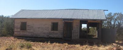
After around 6.8 miles of slow, careful driving we found that we had wound our way deep into Railroad Draw. After another mile we were out of the draw and had arrived at Henderson Flat. There we found an old, abandoned two-room bunkhouse (see photograph, next page) and a large steel water tank located under a catchment structure designed to funnel rainwater into the tank.

Steel tank located under catchment structure – note that the “roof” 
slopes to the center, funneling water into the tank
The above photograph was taken from a window of the old bunkhouse.

Deserted bunkhouse at Henderson flat
We saw a trail sign near the bunkhouse that at first caused us to think this place was called Lonesome Pocket; however, on further consideration, it was obvious that the sign only marked a trail that leads to Lonesome Pocket which, I later determined, is about two miles north (slightly east) from this point.

Leaving the bunkhouse/steel tank area, we headed on south on FR 181, coming, after less than a tenth of a mile, to the remains of Henderson Tank. This was a large tank formed by damming the wash that runs parallel to and on the east side of the road. The only remaining sign of the tank is the remains of the old earthen dam which ends at a rock wall that formed one side of a spillway, necessary to prevent water from overflowing the dam and washing it away.

The rock wall shown here forms the end on the earthen dam that trapped 
intermittent stream flow and retained it in “Henderson Tank.”
I had thought that the trip from Henderson Flat to the end of FR 181 where we intended to camp would only be about two miles. It turned out to be 5.5 miles and was the roughest part of the entire trip, taking an entire hour to drive. We did, however, eventually reach the end of the road and found ourselves just at the edge of Sycamore Canyon Wilderness.

Signage and unused check-in box marking the entrance of Sycamore Basin 
Trail #63 into the Sycamore Canyon Wilderness.
We wanted to find the Indian Ruins before dark, but delayed long enough to set up our tents before starting the search. We had been told that one should continue for a short distance from this point along an old jeep road running almost directly east into the wilderness area. When we came to the end of the jeep road, we were alongside a wash that ran downhill from a saddle between two hills. We could see a prominent rock ledge below the saddle on the right side of the wash that might be difficult to climb; however, the left side of the wash was very steep and looked even more difficult. Obviously, we would need to ascent to the saddle along the right side of the wash and, looking across the wash from where we were standing, just a few yards from the very end of the jeep road, a trail was clearly visible leaving the other side.

Trail visible from the old jeep road as it leaves the other side of the 
wash just across from the end of the road
On leaving the wash, the trail wound back to the left and came out in the saddle shown in the left of the above photograph. It is a bit rocky, but relatively easy to follow. If one does go astray, it soon becomes apparent and one has only to retrace a few steps and try another path. Except for a few very rocky spots, never more than a few yards in length, the trail is really quite visible all the way to the ruins.

On arriving at the saddle, we were faced with two smaller saddles ahead to the left. The first, leftmost, saddle is flanked by two substantial peaks, the second or rightmost saddle, however, is formed by a substantial peak on one side but by a much smaller outcropping of rock on the other. This is the one that leads to the Indian Ruins. It would, in any case, be difficult to go wrong here, as a very visible trail leads up to the correct pass.

On reaching the saddle, we were rewarded by a fantastic view down into Sycamore Canyon, across to Casner Mountain on the other side and on to the snow-clad San Francisco Peaks beyond the Mogollon Rim.

View from the saddle as we approached the Indian Ruins
We lingered awhile in the saddle to enjoy the view and then pushed on to find the ruins. The trail descended steeply for a short distance from the saddle before leveling off and continuing along the cliff face. We didn't know how much farther it would be to the ruins and were conscious of the time. The ruin, however, turned out to be only about 200-yards beyond the saddle. None of the reports I had read seemed to indicate that it was this close and I was pleasantly surprised to look up an see it, tucked neatly into the cliff wall, directly above me.

Indian Ruins in Sycamore Basin
Jim climbed up first while I waited below to take a picture.

Jim Manning looking out over Sycamore Basin from the Indian Ruins
We spent a considerable amount of time examining the ruins. The following two pictures show one of the rooms from above and from inside.

Room from above
Room from inside
As we descended from the ruin, I paused to take a photograph of a supporting wall. Note the bulging area; it is just below and provides support for the outer wall of the room in the above two photographs.

The bulging section is a supporting wall
About half way back to the saddle through which we had passed to reach the ruins, I noted a sign tacked to a tree about 15 yards below the trail. A very faint trail led downward at this point and we at first thought it must be where hikers had descended to read the sign which was unreadable from the main trail. However, the faint trail turned before reaching the tree and led a few yards along the cliff face to second, much smaller, ruin (see photograph at right). This ruin consists basically of a single still-standing wall that has mostly been reconstructed. However the first run of rocks in the lower right quadrant still have some mud plaster left. Rocks from the other walls of the structure are scattered about, some appearing as if walls had been deliberately pushed over.

After a quick look around this ruin, we climbed back up top the main trail, pausing along the way to examine the sign (see photograph at left) that had led us to leave the main trail and discover the second ruin. The sign announced that this is an “Archaeological Site” which is “monitored by the Arizona Site Stewards.”

It was now well past sundown on this side of the mountain and we lost no time in climbing back up to the saddle and returning to camp. We had accomplished our primary goal for the trip and were now free to explore whatever else we chose.

As we approached our camp. We gathered the materials we would need to start a fire – mainly dry grass and some small twigs for kindling. However, when we arrived back in camp we found the sun still well above the horizon on this side of the mountain, so we put our kindling aside and set out to explore some interesting outcroppings in the cliff wall just north of us. We left camp following Trail 53 (Henderson Flat Trail); however, after finding a few cairns, and not much else, along the way, we gave that up and just headed for the cliff. We found, as expected, that the outcroppings were formed by spires of soft rock protected by harder overlying caps. They stood close to but apart from the cliff face itself and formed small alcoves. The photograph shown below was taken from one of those alcoves. Despite appearances, the rock formations at the top of the photograph are not joined but stand apart when not viewed from an angle.

Looking out from an alcove
Looking out to the south, across Packard Mesa, from our location, we could see Mingus Mountain and Woodchute Mountain on the horizon.

Mingus and Woodchute Mountains on the horizon
Using his field glasses, Jim could make out the “J” on Cleopatra Hill above Jerome, both from our perch on the cliff wall and later from the camp site. Later that night, I found that I could just make out the faint glow of light from Jerome itself.

We were back at camp with a good fire going in time to have a hot meal by dark. Jim had brought a camp lantern with him. However, we really didn't make much use of it, as we were both tucked snugly into our tents soon after dark.

The National Weather Service forecast called for a low of 28 degrees F and I think they were about spot on. At least we had ice in our water bottles the next morning and the campfire, as we prepared and ate breakfast, felt very good indeed.

After breakfast we broke camp, extinguished our fire and then decided to hike a distance into Sycamore Basin on Trail 63 to see what the trail descent looked like. We found it to be less steep than we had feared. The trail is well-constructed with erosion barriers placed along the way and is in reasonably good condition. We followed it for about a mile through a pinion pine and juniper forest, passing an old unmarked grave site along the way. Then, looking ahead, we could see that it continued for a distance climbing and falling across gentle forested slopes; we had seen what we came to see, so we turned back after having descended only about a mile into the wilderness area. By returning to camp now, we would be able to make make it back as far as Henderson Flat and eat lunch at the old bunkhouse. That would enable us to get back home by the middle of the afternoon.

Our hike from the camp (which, incidentally, was at the end of Packard Mesa Trail #66 as well as at the end of FR 181) to the Indian Ruins we visited is shown in red on page 1 of the included map (see next page). Our trip to visit the the cliff alcoves is shown in light green, FR 181 is shown in dark green, the hike into Sycamore Basin on Trail 63 is shown in cyan and Trail 53 is shown in yellow.

It was only about 0.7 miles, one way, from our camp to the Indian Ruins we visited; our hike along the cliff walls to investigate alcoves was about 0.8 miles round trip; and our hike on Trail 63 was some 2 miles, round trip.

For future reference, there are three other Indian Ruins shown along the cliff walls just north of the ones we visited. I have identified the locations of these and have shown them on page 2 of the included map (see Ruin 1, Ruin 2 and Ruin 3). I located these sites using a USGS Survey overlay in Google Earth and transposed them into the mapping program I use.