On
14 September 2013, the Skyliners hiked from Lockett Meadow to Bearjaw
by way of the Inner Basin and Waterline Trails. We left Cottonwood
just after 0700 and were at Locket Meadow at about 0840. The 4.5
mile stretch of dirt road from Hwy 89A to the trailhead at Locket
Meadow was in better shape than we had expected. Repairs have been
performed recently and, except that it is still very narrow and has
some deep ruts carved by recent heavy rains, is easy to navigate.
Camping
at the meadow is available only at numbered sites which are available
for $6.00 for day use or $12 for overnight camping. Free parking for
hikers is provided at the trailhead.
 We
parked at the clearly-marked trailhead, paused just long enough to
review the trailhead sign (right),
and quickly headed up the trail toward Jack Smith Spring where we
expected to join and turn north on the Waterline Trail.
We
parked at the clearly-marked trailhead, paused just long enough to
review the trailhead sign (right),
and quickly headed up the trail toward Jack Smith Spring where we
expected to join and turn north on the Waterline Trail. This
was my first time on the Inner Basin Trail for almost a decade, well
before the 2010 Schultz fire, and I noted evidence of that fire soon
after we started up the trail. Fire damage was restricted to the
south side of the trail and we were soon past the burned area.
Despite the devastation caused by forest fires, they do have some
unique and, in their own way, appealing after effects. Here, the
silent dead trees still stood sentinel while below the forest was
covered with new-growth aspen along with scattered wildflowers, such
as the asters shown here (above left),
that are seldom seen in pristine forests.
This
was my first time on the Inner Basin Trail for almost a decade, well
before the 2010 Schultz fire, and I noted evidence of that fire soon
after we started up the trail. Fire damage was restricted to the
south side of the trail and we were soon past the burned area.
Despite the devastation caused by forest fires, they do have some
unique and, in their own way, appealing after effects. Here, the
silent dead trees still stood sentinel while below the forest was
covered with new-growth aspen along with scattered wildflowers, such
as the asters shown here (above left),
that are seldom seen in pristine forests.
We
were soon past the burn area and back into undamaged (at least by
fire) forest. The trail at first continued straight up the slope
toward Jack Smith Spring through a forest of mixed vegetation,
primarily pine and fir. Then, we emerged into a beautiful, almost
ethereal, zone of quaking aspen and grass-carpeted forest.
 |
Quaking aspen in a grass-carpeted forest
|
The
trail now started a series of switchbacks and I realized that this
was not the route I had followed when I last hiked on the Inner Basin
Trail. I have faint memories of following the traces of an old road
up the mountain slope. Now, there were no traces of old road and we
were following an obviously rather newly-built and well-engineered
trail, designed to minimize erosion and take the drudgery out of what
was, after all, a rather steep climb, rising almost 800 feet in the
first 1.7 miles.
 Having
plotted the old trail using a dated topographic map, I was expecting
to reach Waterline Trail at Jack Smith Spring after traveling 1.7
miles on Inner Basin Trail. Unexpectedly, the newly-constructed
trail brought us out on Waterline Trail 0.2 miles south of the
spring. A sign posted at the trail junction (right)
indicated that going south would take us to Schultz Pass Road, so we
knew that we were still south of the spring and would have to head
north to reach it. In any case, Bearjaw was certainly still well
north to the north.
Having
plotted the old trail using a dated topographic map, I was expecting
to reach Waterline Trail at Jack Smith Spring after traveling 1.7
miles on Inner Basin Trail. Unexpectedly, the newly-constructed
trail brought us out on Waterline Trail 0.2 miles south of the
spring. A sign posted at the trail junction (right)
indicated that going south would take us to Schultz Pass Road, so we
knew that we were still south of the spring and would have to head
north to reach it. In any case, Bearjaw was certainly still well
north to the north.
Waterline
Trail, following the path of a waterline serving Flagstaff, begins
at Schultz Pass, runs along the northeast slope of the San Francisco
Peaks into the Inner Basin and continues north and northwest to
Abineau Canyon. The below sign describes it well.
 |
Sign posted on Waterline Trail at Jack Smith Spring
|
We continued the short
distance on Waterline Trail to Jack Smith Spring. There we saw a
good chance to combine a group photograph with an informational sign.
 |
Left to right: David Beach. Miriam Sterling, Jerry Helfrich, Lila Wright and
Ann Urick – author not shown
|
 Another
sign (left) provided the distances
to various other points. If accurate, the distance of 3 miles given
to Bearjaw meant that it would have been 3.2 miles from the point we
left the Inner Basin for Waterline. However, I had plotted the
distance as being 3.9 miles. As it turns out, our GPS track from
where we first entered Waterline Trail to Bearjaw, perhaps a few
yards beyond the Bearjaw Trailhead, measured 3.1 miles.
Another
sign (left) provided the distances
to various other points. If accurate, the distance of 3 miles given
to Bearjaw meant that it would have been 3.2 miles from the point we
left the Inner Basin for Waterline. However, I had plotted the
distance as being 3.9 miles. As it turns out, our GPS track from
where we first entered Waterline Trail to Bearjaw, perhaps a few
yards beyond the Bearjaw Trailhead, measured 3.1 miles.
After
only a short pause at Jack Smith Spring, we continued on toward
Bearjaw. We had set that point as our goal because several of us had
already hiked the section of Waterline Trail between there and the
trail's end at Abineau Canyon as part of the
Abineau-Waterline-Bearjaw Trails loop.
The
road was not quite as well-maintained along this section, but was
still in very good condition. While we saw no vehicle tracks, there
was ample evidence in the way of fallen trees removed from the road,
that it was being maintained well enough to permit use by waterline
service vehicles. That, along with the very gentle slope and the
beautiful surrounding forest, made it an absolute pleasure to hike.
 |
View of Waterline Trail north of Jack Smith Spring
|
Because
of the heavy forest, we had only an occasional view of anything other
than our immediate surroundings. There were, however, a couple of
places where openings provided farther off views. The following
photographs were taken from such viewpoints.
 |
Looking down on Lockett Meadow where we started our hike from
Waterline Trail
|
 |
Looking generally northeast from Waterline Trail north of Jack Smith Spring
|
 We
arrived at the Bearjaw Trailhead (right)
at about noon. The trail we were on was mostly shaded and there was
a light cool wind blowing which, coupled with perspiration from the
hike, made us all a bit chilly, so we continued on past the trailhead
for several yards to stop for lunch in a sunny spot with several
fallen logs that would serve as seating.
We
arrived at the Bearjaw Trailhead (right)
at about noon. The trail we were on was mostly shaded and there was
a light cool wind blowing which, coupled with perspiration from the
hike, made us all a bit chilly, so we continued on past the trailhead
for several yards to stop for lunch in a sunny spot with several
fallen logs that would serve as seating.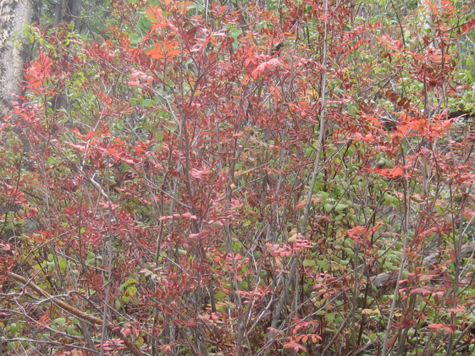
There
was the possibility of thundershowers, a 10% chance according to the
Weather Service, and the ground was still too wet from previous rains
for me to take my customary noon nap, so we were soon on our way back
down the trail. As always, I noticed different things on the way
back. For instance, this first hint of fall color prominently
displayed along the road bank (left).
 We
hurried along as we neared the end of the trail because heavy clouds
had gathered and we could hear the rumble of thunder in the distance.
Fortunately, we received nothing more than a heavy sprinkle before
arriving back at the parking lot. The rain continued to hold off for
the drive back along the dirt road to Hwy 89A, a fact that pleased me
immensely because I had seen a gorgeous yellow flower (right)
on the drive in that I wanted to stop and photograph on the way back.
We
hurried along as we neared the end of the trail because heavy clouds
had gathered and we could hear the rumble of thunder in the distance.
Fortunately, we received nothing more than a heavy sprinkle before
arriving back at the parking lot. The rain continued to hold off for
the drive back along the dirt road to Hwy 89A, a fact that pleased me
immensely because I had seen a gorgeous yellow flower (right)
on the drive in that I wanted to stop and photograph on the way back.
The
total distance for this hike as shown by the red GPS track on the
included map (below) was 9.6 miles
round trip, the total ascent was 1,071 feet and the highest elevation
was about 9741 feet.

No comments:
Post a Comment