Several
Skyliner members had hiked to Kendrick Peak a few years ago. The
hike to the peak using Kendrick Mountain Trail #22 is 4.6 miles one
way. That includes the 4.2 mile length of Kendrick Trail and an
additional 0.4 miles from the trailhead to Kendrick Watchtower. For
the present, 14 May 2016, hike I looked at three alternative trails:
Bull Basin Trail #40 which ascends the mountain on the north side,
Pumpkin Trail #39 which ascends the west side of the mountain and
Kendrick Firewatcher Shortcut which uses a part of Kendrick Mountain
Trail but starts at a different spot and runs north of Newman Hill.
Thinking that the shortcut sounded interesting I chose that option.
We
left Cottonwood at 0700, drove north on I-17 to its end at I-40,
continued straight on Milton, turned right onto Santa Fe Ave and then
north on Humphreys (US 180). We followed US 180 for 17.2 miles,
turned left onto Forest Road 193, drove 3.3 miles and turned right on
FR 171, drove 2.0 miles and turned right onto FR 190. We then
continued for another 1.1 miles on FR 190, passing the Kendrick
Mountain Trailhead and climbing through the ponderosa pine forest
between Newman Hill and East Newman Hill, to arrive at the departure
point for the Firewatcher Shortcut.
There
we found one already-parked vehicle, a modest, dark colored Toyota,
parked heading back down the slope. From where the vehicle was
parked it could easily, with a gentle shove by the driver, have
coasted down to the road and all the way back to Kendrick Mountain
Trailhead, 0.7 miles away. That reminded me of my first car, a 1936
Chevrolet; when I drove it to town, I always searched until I found a
hill to park on, just in case it wouldn't start when I was ready to
go home. That precaution served me well at the time.
There
is no marked trailhead, just a wide open area in the saddle between
the two ridges. Apparently the shortcut is primarily used by
personnel who man the Kendrick Lookout Tower; it provides them with a
place to park apart from the busy Kendrick Mountain Trailhead. An
additional benefit is that a car parked here can be viewed from the
tower, located 1.1 miles away and high above the parking area.
Before
heading across the road to climb the opposite bank along what
appeared to be a very faint trail, we stopped for a group photograph.
 |
| Left to right: Karl Sink, Collene Maktenieks, Anita Jackson, Daisy Williams, Loren Pritzel, Lila Wright, Dave Beach, Jim Gibson, Betty Wolters, Ellen McGinnis and James McGinnis – author not shown |
 The visible trail
didn't last very long; it just ran up the bank, turned to follow
along a short stretch of fence, faintly seen in the photograph
(right) which has been erected to
protect a stand of tender, young quaking aspens. When the trail
ended, we just followed a 2013 GPS track.
The visible trail
didn't last very long; it just ran up the bank, turned to follow
along a short stretch of fence, faintly seen in the photograph
(right) which has been erected to
protect a stand of tender, young quaking aspens. When the trail
ended, we just followed a 2013 GPS track.
The
track led us basically along the spine of a gently sloping ridge just
north of East Newman Hill. We were in relatively open country,
populated by lightly-scattered ponderosa pines. We were basically
just bushwhacking, using the GPS track as a guideline, and winding
our way around isolated rock outcroppings.
 |
| Scattered ponderosa pines through which we hiked |
As
we climbed higher we had excellent views across East Newman.
 |
| Panoramic view of East Newman Hill and beyond |
About
a mile into our hike we came to the top of the gently-sloping ridge
we had been following. Another tenth of a mile down the other side
of the ridge, in a saddle between it and Kendrick Mountain proper, we
intersected with Kendrick Mountain Trail #22 which we would follow
to Kendrick Lookout Cabin. Since leaving FR 190 at the fenced-in
stand of aspen, we had hiked a distance of 1.1 miles and ascended a
total of 765 feet. From this point to the cabin, a distance of 2.2
miles we would ascend another 1348 feet feet along a trail that would
include 16 switchbacks. We pressed on, coming soon to the first
switchback and from there had an ever-changing view as we climbed
higher on the mountain. Meanwhile, the ponderosa pines were replaced
by a mixed conifer forest of fir and spruce. The white bark of an
occasional aspen grove struck a pleasing contrast with the conifers.

From different vantage points along the way we could see the, still
snow-capped, San Francisco Peaks (left),
some 11 miles to the southeast.
Then,
just after our ninth switchback, we came to a fern-covered open spot
with a great panoramic view of the open country visible between the
San Francisco Peaks to the southeast and Bill Williams Mountain in
the southwest. Hikers are seen standing on the trail in the lower
right corner of the below photograph .
 |
| A panorama of the open country to the south, from an elevation of 9330 feet |
It
was still pretty early for flowers at this elevation and there were
few to be seen. An exception was several hardy dandelions, growing
all in a patch, (below left);
also quite colorful was an Oregon grape with its bright yellow
berries peering shyly from behind leaves that had already turned dark
red (below right).
 |
A patch of dandelions Oregon grape
|
We
made one brief pause to rest on the way up the mountain; but the
hikers soon seemed ready to go, so we quickly pushed off again.
 By
my GPS track, it was 1236 when we turned the corner at switchback 16,
no more than 200 yards from Lookout Cabin. According to a National
Forest sign posted inside, the “Old Lookout Cabin” was built by
the lookout in 1911-12 and served as the lookout's home. He kept a
horse at the site and rode it to the peak, about 300 feet higher in
elevation, each morning to watch for fires. He then returned to his
cabin home each night. This cabin (right)
served as home for the lookout until the 1930s.
By
my GPS track, it was 1236 when we turned the corner at switchback 16,
no more than 200 yards from Lookout Cabin. According to a National
Forest sign posted inside, the “Old Lookout Cabin” was built by
the lookout in 1911-12 and served as the lookout's home. He kept a
horse at the site and rode it to the peak, about 300 feet higher in
elevation, each morning to watch for fires. He then returned to his
cabin home each night. This cabin (right)
served as home for the lookout until the 1930s.
Kendrick
Mountain Trail #22 ends at the cabin, still 0.4 miles (by a
switchbacking trail) short of the present-day Kendrick Lookout. Bull
Basin Trail also ends at the cabin. The end of Kendrick Mountain
Trail is marked by a somewhat ambiguous sign (below
left). The small arrow shown on
the sign, left of the lettering “To Trailhead,” points directly
back down the trail we had just traversed. Of course, there is a
trailhead that way; but it is 4.2 miles away. I think the old post
with the rock atop it (below right)
once carried a sign marking this spot as the beginning of Bull Basin
Trail #40. Bull Basin Trail runs straight through the snowdrift seen
here and continues down the north side of Kendrick Mountain.
 |
| Kendrick Mountain Trail- Missing Bull Basin Trail- head sign head sign |
We
didn't linger at the cabin on the way up; we wanted to eat lunch at
the helicopter pad on Kendrick Peak and we still had 14 switchbacks
and 0.4 miles to go. Another trail sign (below
left) marked the way. The 14
switchbacks, being all packed into a very short trail, went fast. At
switchback 13, just a few yards below the Lookout Tower, we found yet
another trail sign, this one marking the beginning of Pumpkin Trail
#39, running down Kendrick's west slope (below
right).
 |
| Kendrick Lookout Trail- Pumpkin Trailhead head |
Another few paces and
we turned the corner at switchback 14 and arrived at Kendrick
Lookout. The National Historic Lookout Registry provides the
following information about the site:
Although
the 10’ steel tower with metal 14’x14’ flatroof cab and catwalk
was constructed in 1964, the previous L-4 structure on Kendrick
Lookout was built in the early 1930s. A log cabin built in 1911 one
quarter mile below the peak as sleeping quarters is the second oldest
example of a fire detection structure present in the southwest region
(Arizona and New Mexico). The current tower is in active service.
1
For the reader who
might wonder what an L-4 structure (mentioned in the above quotation)
is, the following information is provided by the Forest Fire Lookout
Page:
L-4 = standard 14 x 14 foot frame pre-cut lookout house built from 1929 through 1953, also known as an "Aladdin." It has a peaked roof, and wooden panels that are mounted horizontally over the windows in the summer to provide shade, and lowered over the windows in winter. Early models have a gable roof; later models have a hip roof.
 In
this photograph (left),
the bottom deck of the lookout tower can be seen at upper left, a
path is visible at lower right, a propane meter is shown just below
and right of center and a barely visible hiker can be seen eating
lunch just below and right of the meter.
In
this photograph (left),
the bottom deck of the lookout tower can be seen at upper left, a
path is visible at lower right, a propane meter is shown just below
and right of center and a barely visible hiker can be seen eating
lunch just below and right of the meter.
Being
quite hungry, I rushed on past the tower and settled on the
sun-warmed concrete pad to eat lunch and take a nap. Sooner than I
would have liked, I was awakened by a cool, brisk wind that came up
in conjunction with dark clouds that covered the sun. I reluctantly
picked up my pack and trudged back to the tower where I paused to
look back to the now-deserted concrete pad and the dark, threatening
skies west and southwest of us. Even under a cloudy sky, I could
still make out Sitgreaves Mountain, left of center, and Bill Williams
Mountain, on the horizon left of Sitgreaves.
 |
| View from Kendrick Peak looking west-southwest |
A
woman volunteer was manning the tower this weekend; it was apparently
a a regular weekend event for her. Lila apparently chatted with her
for some time while I was sleeping on the helicopter pad. And learned
that the Toyota we had found parked below belonged to her. She was
surprised that we had taken the Firewatcher Shortcut, apparently
thinking that only the people manning the lookout knew about it.
Judging from the lack of any discernible trail, I think she was very
nearly right. While eating lunch, I overheard a couple of hikers
discussing a nifty looking “sticker” they had acquired at the
tower.

The sticker turned out to be from a peel-off strip of Smokey the Bear stickers (right).
I
paused on the catwalk to photograph the San Francisco Peaks (below)
before descending the tower for the trek back to our cars, some 2300
feet lower and 3.7 miles away.
 |
The San Francisco Peaks from Kendrick Lookout Tower
|
One
of our hikers had not had time to eat lunch at the peak, so we
stopped at the old Lookout Cabin and I took a short nap on the
bare-springs of a bunk bed while the hungry hiker ate.
When
we reached the Firewatcher Cutoff, nine of our hikers continued for
another 2.0 miles along Kendrick Mountain Trail to the trailhead.
The author and the two drivers returned by way of the 1.1-mile
shortcut to where we had parked and then drove back along FR 190 for
0.7 miles to the trailhead. We all arrived at about the same time,
ending our hike at approximately 1630. The cleaned-up GPS track
showed the hike, using the Firewatcher Shortcut, was 7.4 miles in and
out (8.3 miles for those who returned all the way by Kendrick
Mountain Trail). The maximum elevation was 10413 feet ( a bit more
if one measures from the tower itself) and the total ascent was 2379
feet.
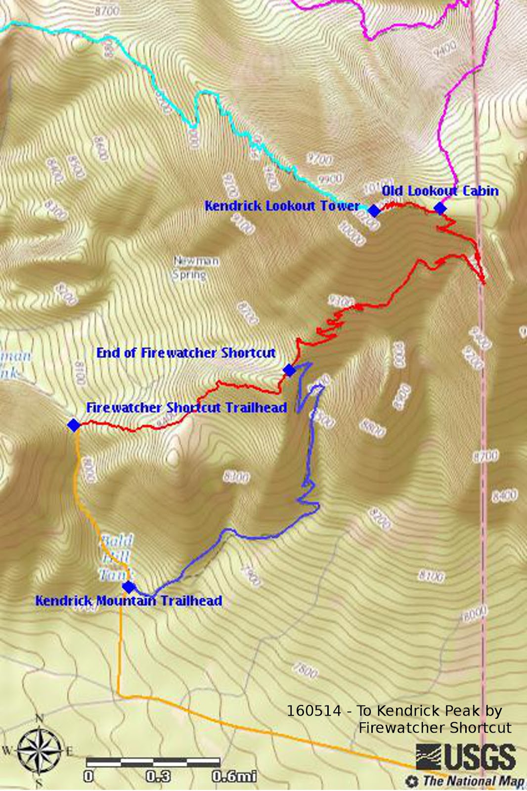
The
attached map (below) shows our GPS
track, using the Firewatcher Shortcut, to the tower in red. The cyan
track shows a section of Pumpkin Trail, the magenta track is a
section of Bull Basin Trail and the blue track is the lower part of
Kendrick Mountain Trail, the path followed by nine of our hikers for
the return trip. Finally, the dark yellow track is a section of
Forest Roads 171 and 190 that we followed to access the Kendrick
Mountain Trailhead and the Firewatcher Shortcut Trail.