On
a sunny day with a high, thin layer of clouds providing some
protection on an unseasonably warm late winter day, sixteen Skyliners
hiked Bear Mountain Trail on 16 March 2013.
Thirteen
hikers (Dave Beach, Miriam Sterling, Frank Lombardo, Collene
Maktenieks, Anita Jackson, Dolly Yapp, Jim Manning, Donna Goodman,
Daisy Williams, Betty Wolters, Lila Wright, one unnamed hiker and the
author) gathered at Cottonwood and carpooled to the trailhead. From
Cottonwood, we traveled north to Sedona on Hwy 89A and turned left
onto Dry Creek Road. About 2 miles from Hwy 89A we passed Vultee
Arch Road leading off to the right. After about another 0.85 miles
(2.85 miles from Hwy 89A) we reached a stop sign. Long Canyon Road
leads to the right from here. We turned left onto Boynton Pass Road,
traveling another 0.6 miles to reach a second stop sign at the
junction with Long Canyon road. Turning left we continued on Boynton
Pass Road for about another 1.25 miles before turning into the
trailhead parking lot for Doe Mountain and Bear Mountain Trails.
Three
additional hikers (Becky Fowsky, Mary Gavan and a second unnamed
hiker) were waiting for us there.
We
crossed the road and found a graduate student ensconced in a camp
chair at our trailhead. He was doing a paper on hiking in the
wilderness. Apparently, the paper was trying to determine what
hikers expectations were as they headed into the wilderness and
whether those expectations had been met when they returned.
Scholarly research on the benefits of wilderness areas seemed a good
cause, and we stopped long enough to fill out a short questionnaire.
 The
trail leads generally headed northwest for its entire length. During
the first quarter of a mile, crossing a mostly flat plain bisected by
deep-cut gullies. It then continued up the slope of Bear Mountain,
gently at first, but rapidly becoming quite steep and climbing 1000
feet in the next mile.
The
trail leads generally headed northwest for its entire length. During
the first quarter of a mile, crossing a mostly flat plain bisected by
deep-cut gullies. It then continued up the slope of Bear Mountain,
gently at first, but rapidly becoming quite steep and climbing 1000
feet in the next mile.
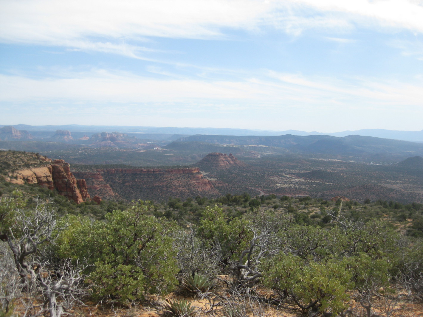
The
photograph shown here (right),
taken shortly after we started the climb up the steep mountain slope,
shows the trail crossing the flat plain below to the parking area
nestled at the base of doe Mountain.
After
a hard climb we found ourselves nearing the top of the
hematite-tinted sandstone (red rock) and the mountainside was
littered with fallen cream-colored rock from the overlying layer.
The following photograph shows hikers nearing the top of the red-rock
formation.
 |
Hikers nearing the top of the red-rock formation
|
When
we were about a mile from the trailhead we could look southeast
across a small canyon to beautiful red-rock formations on the other
side and on across Sedona to Munds Mountain looming in the distance.
 |
Red-rock formations across a small canyon and Munds Mountain looming
in the distance beyond Sedona.
|
After
topping the red-rock formation, the trail lead gently upward for a
distance then started a steep climb once again. We were hiking along
a ridge that, with intervening saddles followed by ever steeper
climbs would lead us to the top of Bear Mountain which still loomed
high above us.
Just
over half way up the trail we topped a small summit of the ridgeline
we were following and had our first glimpse of what lay on the other
side of the mountain. In the following photograph, red sandstone
spires arise from the bottom center pointing to Casner Mountain in
the distance while the cream-colored shoulder of Bear Mountain
intrudes from the right.
 |
First view of the terrain beyond Bear Mountain
|
The
trail was generally easy to follow with small cairns built by
previous hikers placed along the way. There were occasional side
paths leading off to viewpoints, but if one did take one of these in
error, the mistake soon became apparent.
We
became pretty scattered out on the way up the mountain, hiking in
four different groups. One group decided to stop for lunch part way
to the end of the trail and turn back from there. The other three
groups went all the way to the “top” only to discover that it was
just the end of the trail and that the highest point on Bear Mountain
lay about a mile north and another 100 feet higher. No one seemed
disposed to go another mile, closer to two along the course we would
have had to take.
By
the time I arrived at the trail's end, those who had arrived first
were almost ready to start back. I ate a quick lunch and settled in
for my customary nap, only to be awakened almost immediately by their
departure. I reluctantly donned my pack and was on the trail shortly
after they left. Betty was still with me, I think having been
assigned as my keeper.
On
the way back down, I stopped to photograph the Cockscomb formation
and Doe Mountain from high up on Bear Mountain.
 |
Cockscomb formation (center) and Doe Mountain just to its left
|
I
certainly did miss that nap and was really dragging when we finally
completed the hike. We had, according to my GPS hiked only 4.4
miles. However, the instrument gave our total ascent as 2037 feet.
From the time we had left the plain that lies between the parking lot
and the start of the climb, we climbed about 1000 feet per mile to
reach the end of the trail. I don't mind climbing over 2000 feet,
but I do like it to be spread out over a greater distance than two
miles.
We
found the graduate student still manning his post at the trailhead
and paused for his follow-up questions.
After
getting home and soaking in the tub for half an hour, I thought it a
great hike.
Our
GPS track is shown in red on the included map (below).
The blue track is taken from a 2 February 2010 hike to an old still
site in Fay Canyon.

No comments:
Post a Comment