Day
1 – Background and Travel to the Border Area
Gordon
Bice, Donna Goodman, Dolly Yapp and the author had hiked the Paria
Canyon from White House, UT to Lees Ferry, AZ in May 2011. Lila
Wright and Daisy Williams who were camping in the area with Kwi and
Lynn Johnson, saw us off at White House and then hiked on local
trails before returning home. In March 2012, the author along with
several other Skyliners, visited White Pocket on an overnight
campout.
This
trip was intended to repeat some of the hikes Lila and Daisy did in
2011. We intended to eat an early dinner in Page on Friday, 20 May
and then find a place to camp at either the Grand Staircase-Escalante
National Monument in UTAH or across the Arizona State line near the
Vermilion Cliffs National Monument. We had hikes planned for both
areas.
We
left Cottonwood just after noon on 20 May 2016, took SR 260 to Camp
Verde, Interstate 17 to Flagstaff and continued north on US 89 to
Cameron for a planned rest stop. I hadn't driven this way for
several years and was surprised to see that major improvements had
occurred in the interim. In addition to reconstruction of the bridge
across the Little Colorado River, Cameron now has sidewalks along the
main highway through the settlement. The photograph (below)
shows a section of the highway looking south from the bridge.
 |
| Recently reconstructed highway with sidewalks |
 After
a very brief rest stop we continued north on US 89 toward Page,
noting a two-story hogan (right) in
the distance west of the highway and just north of the Little
Colorado; it was the only multi-level hogan we had ever seen and we
thought it must belong to a very prosperous but traditional Navajo.
After
a very brief rest stop we continued north on US 89 toward Page,
noting a two-story hogan (right) in
the distance west of the highway and just north of the Little
Colorado; it was the only multi-level hogan we had ever seen and we
thought it must belong to a very prosperous but traditional Navajo.
Just
north of Cameron we started to see the weird “anthill-like”
formations that I remembered from previous travels in this area. At
the time, I had decided that they were formed from a layer of shale
with a harder rock layer overlying it. It appears that the
protective overlying layer has eroded away unevenly leaving only
small areas (caps) protecting the softer shale layer underneath,
while the surrounding unprotected shale has rapidly eroded away.
Meanwhile, the isolated protective caps themselves are slowly, being
being eroded away, leaving the anthill-shaped piles of shale fully
exposed, as shown in the photograph (below),
to rain and wind.
 |
| Anthill-shaped shale piles |
I
have been told that this shale is part of the Chinle Formation (named
for Chinle Valley in Apache County, Arizona), formed during the Upper
Triassic Period, which began some 237 million years ago. The
close-up photo-graph (left)
shows the surface composition of one mound. I have seen this same
color and texture of shale in other places in Arizona and New Mexico:
in the lower part of Paria Canyon, in the White Mountains near Fossil
Creek and in New Mexico between Farmington and Gallup. I would also
see it later on this trip at the Cockscomb Formation in Utah.
We passed the junction
with US 160 which road begins here and leads east through Tuba City
and beyond to end after after 1465 miles at US 64 southwest of Poplar
Bluff, Missouri. Leaving the junction, still on US 89, we traveled
for about 24 miles up Hamblin Wash between Echo Cliffs to the right
and Red Point Hills to the left. At a place called Cedar Ridge, we
left Hamblin Wash and entered Tanner Wash, also labeled Cornfield
Valley at its lower end, and traveled for about another 19 miles with
Echo Cliffs still on our right but with Cedar Ridge to the left, to
arrive at Bitter Springs, the junction with US 89A. Here a left turn
onto US 89A leads straight ahead to cross the Colorado River on
Navajo Bridge and continues west through Jacob Lake to Fredonia
before turning north to reconnect with US 89 at Kanab, Utah.
We
continued north on US 89 which, at this point, turns right and climbs
Echo Cliffs before continuing on to Page. This section of the road
was closed by a landslide on 20 February 2013 and not reopened until
27 March 2015. From here it is only a short distance on to Page
where we stopped at Strombolis Restaurant for an early dinner. After
dinner, we refueled our vehicles to make sure we didn't run out of
fuel in the back country, and continued on US 89, crossing the river
at Glen Canyon Dam and continuing for another 25.1 miles (from the
center of the dam) to Cottonwood Canyon (BLM 400). We had decided
to camp for the night in Cottonwood Canyon so that we would be near
the first two hikes we had planned. We missed the turnoff at first
and had to turn around and retrace our way. The distance from US 89
to Hackberry Trailhead was 14.5 miles and we continued for another
0.7 miles before finding a suitable camping spot. But the road was
very well-maintained and, as the photograph (below)
shows, we had reached our destination, set up our tents and gathered
around the campfire well before dark.
 |
| Left to right: Donna Goodman, Chris Jensen, Beverly Sass, Lila Wright and Dave Beech – author not shown |
 There were cows in the
area and one, having become separated from her calf, raised quite a
ruckus for awhile. Finally, though, mother and baby were reunited
and we all settled in for a good night's sleep under a full moon
(right) and scattered clouds.
There were cows in the
area and one, having become separated from her calf, raised quite a
ruckus for awhile. Finally, though, mother and baby were reunited
and we all settled in for a good night's sleep under a full moon
(right) and scattered clouds.
Day
2 – Climb Cockscomb on #430, Hike in Hackberry Canyon, Hike to the
Toadstools and visit the Old Pahreah Townsite.
The Cockscomb.
We awoke the next morning, 21 May, to a bright day with a beautiful
view of the sheer, colorful western face of the Cockscomb.
 |
| View of the Cockscomb from our campsite |
A Grand
Staircase-Escalante National Monument sign posted at the intersection
of BLM 700 with US 89 provides the following information about the
Cockscomb:
The East Kaibab
Monocline, known locally as the “Cockscomb,” is a wrinkle in the
earth's crust created 40 to 80 million years ago by the forces of
plate tectonics. It begins north of Highway 12 and runs south to the
Grand Canyon.
Other sources disclose
that the Cockscomb is actually just a section of the East Kaibab
Monocline which, according to a Geological Society of America
bulletin, “extends from the San Francisco
Peaks volcanic field, Arizona, north 150 miles to Bryce Canyon,
Utah.”
We had actually been roughly following the monocline on our journey
yesterday as we drove north on US 89. There it was most prominently
displayed by the Echo Hills Cliffs formation.
Leaving
the campsite we drove 0.8 miles back down BLM 400 (Cottonwood Canyon
), past Hackberry Trailhead, to the intersection with BLM 430. We
parked our vehicles at the intersection and started the climb to the
top of The Cockscomb. BLM 430 was in good condition all the way to
the top of the formation; although rather steep in places as it wound
its way around ridges and outcroppings on the way to the top, it
could easily have been driven in a passenger vehicle. But hiking was
better as it gave us time to admire the many variations in color
among the upended rock layers.
 |
| Photograph taken looking west from part way up The Cockscomb |
Note
the upended slab at the right In the photograph (above).
The hard surface, tilted at about a 45 degree east facing angle, is
still largely intact while the broken-up jumble of rock to the west
has largely eroded away to form Cottonwood Canyon.
As
we steadily made our way up the winding road, dark clouds
sporadically drifted across the morning sun; however, they were
widely dispersed and the threat of rain was never very real. The
clouds did, on the other hand, provide us with interesting variations
in shades of colors. In the photograph (below),
for instance, the close-up part of the scene is in the cloud's
shadow, to about the middle of the slate-gray dunes, while the rest
of the scene, across the canyon and to the far distant, dark red
mountain, is viewed in bright sunlight.
 |
Looking across Cottonwood Canyon from The Cockscomb
|
BLM
430 continues across The Cockscomb and, according to Grand
Staircase-Escalante National Monument Visitor Information pamphlet,
BLM-UT-GI-07-003-8000, joins BLM 431, to form a loop which runs
across Brigham Plains and reconnects with BLM 400 about 1.5 miles
north of US 89.
 The
road crossed The Cockscomb in a saddle between two peaks and we
wanted to sit astride the “comb” before heading back, so we had a
short, steep climb ahead of us. In the photograph (right),
Donna and Lila are shown contemplating that final climb.
The
road crossed The Cockscomb in a saddle between two peaks and we
wanted to sit astride the “comb” before heading back, so we had a
short, steep climb ahead of us. In the photograph (right),
Donna and Lila are shown contemplating that final climb.
We
reached the peak and stopped for awhile to enjoy the panoramic view
to the west, stitched together from three photographs (below).
I wondered whether the prominent peak shown on the horizon beyond
the red mountains might be East Temple in Zion National Park.
 |
| Panoramic view looking west from atop The Cockscomb |
After
pausing to enjoy the spectacular view from the top of The Cockscomb,
Lila and I photographed one another sitting on the rim. I used
Lila's camera for her photograph (below
left)
and she used my camera for a photograph of me (below
right).
Lila
Wright on The The author on The
Cockscomb Cockscomb
Looking
east from The Cockscomb we could see BLM 430 winding its way through
scattered junipers and other desert shrubs. This was in distinct
contrast with the mostly bare, rock strewn western slope we had
climbed on our way to the top. We had, however, encountered some
sparse grass and a few flowers along the way. Two of the flowers, a
delicately-sculpted sego lily (below
left), found in a patch of lilies
at the start of our hike, and a prince's plume (below
right), one of a thicket of such
flowers that gave a whole hillside a yellowish tint, are shown here.
Sego
lily Prince's plume
The
hike to the top of The Cockscomb was 2.8 miles (up and back), the
highest elevation was 5550 feet and the total ascent was 769 feet.
Our
track is shown in red on the inserted map (below).
 |
Hike on BLM 430 to the top of The Cockscomb
|
Back
at our vehicles, we drove about 0.2 miles north on Cottonwood Canyon
Road and parked at the Hackberry Trailhead.
Hackberry
Canyon. The stream running down Hackberry Canyon joins
Cottonwood Creek at the Hackberry Trailhead. From the parking area,
we climbed down a low bank to Cottonwood Creek, dry above this point
at the time of our visit. Crossing the dry creekbed we headed along
a faint trail to the mouth of Hackberry Canyon. There we encountered
the front of a light flow of water, slowly making its way across the
dry sand to join Cottonwood Creek. It was carrying foam and light
debris at its crest, indicating an overnight rainstorm somewhere up
the canyon.
 At
first the stream covered only a small portion of the sandy canyon
floor; however, after about 0.3 miles, the canyon narrowed and the
shallow flow covered the entire width, leaving no dry place to walk.
The plan was to hike barefoot up the canyon. Meanwhile, I had
twisted my hip descending the creek bank and was still feeling a
slight twinge. Although I was confident that the pain would go away
with a little more exercise, I had no desire to hike barefoot in a
sandy stream with a twisted hip. While the others removed their
boots, I turned back to the trailhead, taking time along the way to
stop and admire a blooming tamarix plant (above left).
At
first the stream covered only a small portion of the sandy canyon
floor; however, after about 0.3 miles, the canyon narrowed and the
shallow flow covered the entire width, leaving no dry place to walk.
The plan was to hike barefoot up the canyon. Meanwhile, I had
twisted my hip descending the creek bank and was still feeling a
slight twinge. Although I was confident that the pain would go away
with a little more exercise, I had no desire to hike barefoot in a
sandy stream with a twisted hip. While the others removed their
boots, I turned back to the trailhead, taking time along the way to
stop and admire a blooming tamarix plant (above left).
Back
at the trailhead, I found myself a sunny spot, sheltered from the
brisk breeze blowing up Cottonwood Canyon and settled in for a good
nap. I was vaguely aware of campers and hikers stirring in the
background but they never really bothered me.
 Meanwhile,
the other five hikers continued on up Hackberry Canyon. Lila later
provided me with some information about their hike. She described
the hike as being along “a soft, sandy,
one inch deep stream flowing through the approximately 40 foot wide
canyon, inviting hikers to enjoy with bare feet.”
She also provided a photograph (right)
by way of illustration.
Meanwhile,
the other five hikers continued on up Hackberry Canyon. Lila later
provided me with some information about their hike. She described
the hike as being along “a soft, sandy,
one inch deep stream flowing through the approximately 40 foot wide
canyon, inviting hikers to enjoy with bare feet.”
She also provided a photograph (right)
by way of illustration.
She
went on to say that every “turn in
the canyon opens up a view of water-stained, towering cliffs and
arches forming with huge chunks of rocks fallen away.“
Lila, Beverly and Donna stopped after about 1.2 miles at a spot
marked by a “single spire” standing in the middle of the canyon
(below
left)
while Chris and Dave continued for another 0.5 miles to a place
(below
right)
where “small water falls and
rougher rocks ... would require boots” to go farther.”
Spire
in Hackberry Canyon Small waterfalls and rocks
The
Hackberry Canyon hike was 3.4 miles (in and out) for Chris and Dave,
less for the rest of us. The highest elevation was 4954 feet and the
total ascent was 503 feet. These figures are essentially estimates
as the entire track was not GPSed. The hike is shown in red on the
below map.
 |
| Hike in Hackberry Canyon |
Leaving
Hackberry we headed back down BLM 400 aiming for the Toadstools
Trailhead located on US 89 about 1.6 miles west of the BLM 400
intersection. For the first 2.5 miles the road ran closely along
Cottonwood Creek until the creek joined the Paria River. It then
followed closely along the river for about 5.8 miles before veering
east to end at US 89 after another 6.2 miles. After turning away
from the river, we climbed a short hill and came out on a plateau
where we found a field carpeted with primroses.
 |
Field of primroses at Grand Staircase-Escalante National Monument
|
A
closeup of a single primrose is shown here (below
left). A closer look revealed a
number of brilliant yellow bee flowers, or spider flowers, (below
right) growing along the road bank.
A
primrose Bee flowers or spider
flowers
The
Toadstools. The visit to the
Toadstools was a unique and fascinating experience. One could gaze
upon the weirdly-shaped, wind-sculpted rock formations and “see”
all sorts of imaginary creatures. It was almost as though we had
fallen down Alice's rabbit hole and landed in the Land of Oz
To
get there we passed through a hiker's gate in the fenceline and
followed a well-worn trail across a primrose covered field.
Scattered among the primroses were other assorted flowers, making
this a very pleasing hike before we even reached the toadstool
formations. But we were here to see the toadstools and had our eyes
fixed on the colorful rocks on the horizon. As we drew closer the
shapes began to take form. Meanwhile the sand-laden wind picked up,
biting into our faces, clogging our camera lenses and, in general,
giving us a real live demonstration of how the rocks were formed.
 |
Approaching the Toadstool formations
|
The
most prominent of the toadstools are the two shown here (below
left).
However, most interesting to me was a small grouping of “toadstools”
near the white cliff wall (below
right).
These reminded me of the man-made edifice at Stonehenge, albeit on a
much smaller scale.
 |
| Most
prominent A smaller grouping of the “toadstools” near the cliff |
Although
the namesake toad-stool-shaped rocks were quite interesting, my
favorite was one that I called the “Mad Hatter” (left)
The rock wore a red cap as a hat and did, indeed, look as though it
might sit there for a never-ending tea party, a la the Mad Hatter and
the March Hare.
We
found shelter from the wind-blown sand in the lee of a large rock at
the foot of the large toadstool and stopped for lunch. After lunch
we all headed back to the trailhead.
As
we had on the way in we kept strictly to the trodden path except for
those areas where we could walk on rock. This was necessary to avoid
disturbing cryptobiotic soil crust and exposing the soil to erosion
by the seemingly ever-blowing winds.
I
lingered behind on the way out to photograph some of the flowers I
had bypassed before. These included a delicate sand penstemon
(below left)
and a bouquet of lupine and primrose (below
right).
Sand
penstemon lupine and primrose
In
the photograph (below) Beverly Sass
can be seen hiking along the trail heading back to the trailhead. I
took this one last shot at the Toadstools and then hurried to catch
up.
 |
| Path back to the trailhead viewed through a globe mallow |
The
Toadstools hike was about 1.5 miles (in and out). The highest
elevation was 4548 feet and the total ascent was 125 feet. The hike
is shown in red on the below map.
 |
Hike to the Toadstools
|
Our
next stop would be the old Pahreah Town Site. Donna had been there
before in the recent past so she guided us as we drove west on US 89,
turned right onto BLM 585 and continued for another 6.1 miles.
Old
Pahreah (Paria) Town Site. According to a BLM informational
pamphlet titled People
of Paria Canyon - Those Who Came Before,
“Paria” is a Paiute word that “may mean water that tastes
salty.” The early settlers apparently misspelled the word as
“Pahreah;' however, “John
Wesley Powell, the first director of the United States Geological
Survey,”
spelled it “Paria,”
the usage that continues to this day.
The
town of Pahreah, established in 1870 and inhabited until 1929, is
reported to have once had a population of 47 families. During the
1870s the town had “vegetable farms, fruit and nut orchards, and
cattle.”
The BLM pamphlet goes on to report as follows:
Unfortunately,
severe flooding during the 1880s brought alkaline soil and entrenched
arroyos and by 1889, only eight families remained at the settlement.
By the 1930s the town of Pahreah had vanished. Near the abandoned
settlement, now a ghost town being slowly swept away by the river, a
western movie set was built. Here famous characters like Calamity
Jane, Buffalo Bill and others came to life. Zane Grey, a famous
western writer during the 1920s, had some of his novels filmed in the
area, including Revelation, Heritage of the Desert, and A Biography
of Buffalo Jones.
According
to a Wikipedia article titled Paria,
Utah,
the
Paria River flooded annually from 1883 to 1888 and “people
started to move away;”
The article goes on to report that only eight families were left by
1892, “but
for some reason the town was granted a post office that year, under
the name Paria.”
A gold mining operation is reported to have been established at
Paria in 1911 only to be wiped out by flooding within a year. It is
said that the post office closed in 1914 and that the last resident,
a bachelor prospector, left in 1929.
The
Wikipedia article also expands on usage of the site as a movie set,
reporting that after scenes for Buffalo
Bill
were filmed at Pahreah in 1943 it was continued in use throughout the
1950s. In 1961, for the filming of Sergeants
3,
an imitation town was created about a mile west of the old Pahreah.
This new site then fell into disuse after the filming of The
Outlaw Josie Wales
in 1976.
After
severe damage due to flash flooding in 1998, a team of volunteers and
BLM employees replaced the structures in 1999–2001. Finally, the
rebuilt set was destroyed by fire in 2006. All that remains today
are several informational signs providing a brief glimpse of the
town's history. Among these signs is a separate poster (below)
that discusses the old movie set and displays a picture of one of its
long gone buildings.
 |
| Poster at the site of the old Pahreah movie set |
 The
only visible signs of the old movie set we saw were the dirt streets
and a wooden fence that might have been used as part of the set.
There was also a toilet installed nearby (right);
however, I doubt that it was a part of the movie set.
The
only visible signs of the old movie set we saw were the dirt streets
and a wooden fence that might have been used as part of the set.
There was also a toilet installed nearby (right);
however, I doubt that it was a part of the movie set.
The
mountain behind the buildings in the above two scenes is shown in
another photograph (below).
Note the presence of the toilet at left and the conspicuous absence
of the old movie set building.
 |
View of the mountain behind where a movie set building once stood
|
Continuing
on toward the river from the site of the old movie set we came to the
Pahreah Cemetery.
 |
| Left to right in Pahreah Cemetery: Beverly Sass, Lila Wright, Donna Goodman, David Beach and Chris Jensen |
I
think the gravestones seen in in the cemetery must be merely
symbolic; none had names engraved on them. Instead a single larger
stone monument (below),
also visible between Dave Beach and Chris Jensen in the photograph
(above),
has a brass plaque with 13 names, probably all that could be
positively identified as having been buried here, engraved on it.
 |
Names along with dates of birth and death inscribed on a stone monument mounted in the Pahreah Cemetery |
The
cemetery was about 0.6 miles down slope from the site of the old
Pahreah movie set. Another 0.6 miles brought us to the bank of the
Pariah River. Although we took a wrong turn and traveled farther
than that to get there.
We
found nothing at the river bank, no old building foundations or other
structural remains, but a turnaround and a large cottonwood tree to
provide a bit of shade. Of course, we really didn't know exactly
where the old town had stood, so we could easily have overlooked the
old ruins. I did find one reference
to a 1988 visit by one Joe Orman that placed the old town on the east
side of the Pariah. Orman mentioned wading the river to reach it.
That would place the old town snug against the red mountain across
the sandy expanse of river bottom shown here (below).
 |
| Looking across the Paria from the end of BLM 585 |
I
looked back as we made our way back past the old cemetery and the
site of the imitation western town used as a movie set; this parting
view of the area reminded me of a 1907 quotation by Zane Grey that I
had recently read:
"Dawn
opened my eyes to what seemed the strangest and most wonderful place
in the world. Paria Creek watered this secluded and desert bound
spot."
Zane
Grey's words rang in my ears as I stopped along the road to take the
four photographs that went into this panorama (below).
 |
A panoramic view of the mountains at Pahreah
|
Although
the background in this photograph (below)
is repeated from the panoramic view shown previously, I couldn't
resist a view of the mountain framed by prince's plume flowers.
 |
| A mountain at Pahreah framed by golden prince's plume flowers |
This
visit to Pahreah involved no hiking. The blue track below at left
shows our drive from Us 89 to the site of the old movie, the cemetery
and on to the bank of the river.
 |
| Map of the area around the old town of Pahreah |
Our
next goal was the Wire Pass Trail, a trail that starts at BLM 700 and
follows Wire Pass Gulch to Buckskin Gulch. From the intersection of
BLM 585 and US 89 we drove 5.1 miles back toward Page, turned right
onto BLM 700 (House Rock Road) and drove 8.5 miles to the Wire Pass
Trailhead. Rather than stop, we continued for another 1.4 miles to
Stateline Campground on the off chance we could find an open spot
before hiking Wire Pass. The campground was full, so we returned to
the Wire Pass Trailhead to begin our hike, trusting that we could
finish the hike and still have time to locate a suitable camping spot
before dark.
 Wire
Pass to Buckskin Gulch and a Little More. Although the large
parking area was quite busy, we did find parking space. Apparently
the facility was expanded and a toilet added with the use of stimulus
money during the recent recession. It obviously is very popular,
being the take-off point for hikers to the Wave as well as to Wire
Pass. We found an Iron Ranger (left)
posted at the trailhead with clear instructions as to payment of
usage fees.
Wire
Pass to Buckskin Gulch and a Little More. Although the large
parking area was quite busy, we did find parking space. Apparently
the facility was expanded and a toilet added with the use of stimulus
money during the recent recession. It obviously is very popular,
being the take-off point for hikers to the Wave as well as to Wire
Pass. We found an Iron Ranger (left)
posted at the trailhead with clear instructions as to payment of
usage fees.
Instructions
posted atop the Self Service Pay Station (Iron Ranger) instructed us
to insert insert $6 per person or dog into one of the envelopes
protruding at the bottom and leave it in the box. Closer reading of
the instructions revealed that the fee was reduced to $3 per person
for holders of Golden Age Passes; it didn't mention a discount for
elderly canines.
A
nearby sign (below) provided
additional information.
 |
| Information from a nearby National Monument sign |
 The
trail led us back across House Rock Road, across Coyote Wash and
along a well-defined track to a fence with a pedestrian crossing
(right) and then, about 0.2 miles
from the trailhead, entered Coyote Wash and followed it to Wire Pass.
The
trail led us back across House Rock Road, across Coyote Wash and
along a well-defined track to a fence with a pedestrian crossing
(right) and then, about 0.2 miles
from the trailhead, entered Coyote Wash and followed it to Wire Pass.
We
saw several shrubs in bloom along the banks of the wash. These
included a Rosemary mint (below
left) and a sand penstemon (below
right)
Rosemary mint Sand penstemon
Next
we came to an Apache plume shrub (below
left) then passed the turnoff to
the Wave (below right),
0.6 miles from Wire Pass Trailhead.
Apache
plume shrub Turnoff to the Wave
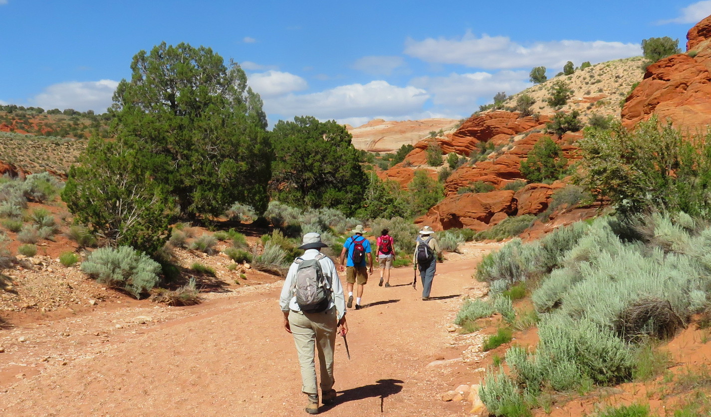
Hiking
down Coyote Wash was easy; although the worn trail occasionally ran
along the bank, it was usually easier to just continue along the
wide, sand and gravel bed of the wash (below).
 |
Beverly, David, Donna and Lila hiking down Coyote Wash toward Wire Pass
|
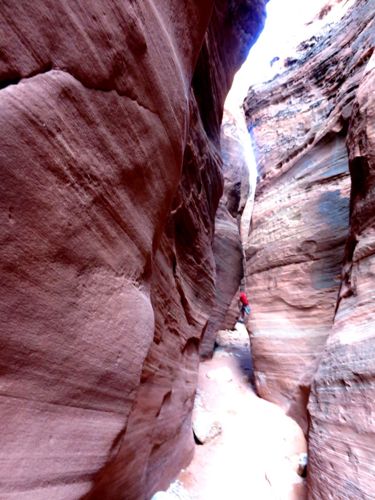
Approximately
0.9 miles from the Wire Pass Trailhead, we left Coyote Wash and
entered the Wire Pass gulch (below
left). My interest now shifted
from flowering shrubs to the colorful, wind and water-sculpted walls
closing in around us. A hiker is shown here (below
right) disappearing around a corner
of the sandstone wall.
Looking
down Wire Pass The walls closed in on
Gulch both sides
Sometimes
the gulch turned so that the sun illuminated its depths as shown
here (below).
 |
A turn in the gulch allowed sunlight to penetrate, fully illuminating its depths
|
At
one point we had to descend a 12-foot high rock ledge (below
left). At another, we passed under
an overhang which almost completely closed the opening above (below
right).
Donna
descending 12-foot An overhang almost
ledge with David waiting closing the top of the
below gulch
At
1630, about an hour after leaving the trailhead we arrived at
Buckskin Gulch. The one-way distance had been about 1.7 miles. At
the Wire Pass/Buckskin junction, still barely within Wire Pass, we
found Indian petroglyphs carved on the wall (below
left); just a few yards away,
around the corner in Buckskin, we saw a securely anchored ammunition
box (below right).
After much straining and prying I managed to open the box and found
a sign-in book inside. I didn't have a pencil handy and the other
hikers had gone ahead, so I just re-closed the box without signing
the log and continued on my way.
Petroglyphs
in Wire Pass Ammunition box holding
at Buckskin sign-in sheet
We
hiked downstream from the junction for about 0.2 miles, passing the
often-mentioned tree trunk (left)
jammed between the gulch walls high above the floor.
It
was now almost 1700 and we had yet to locate a camping spot for the
night, so we went just a short distance further and turned back a
little below the narrow section of Buckskin Gulch pictured (below).\
 |
Narrow section of Buckskin Gulch near where we turned back.
|
We
wasted no time in returning to the Wire Pass Trailhead, retrieving
our vehicles and heading down House Rock Road in search of a
campsite. That, luckily enough, did not take long and we soon found
ourselves setting up at a ready-made fire pit where someone had left
a nearly-new portable hibachi along with a package of very moldy hot
dogs. We cooked with our own camp stoves, leaving both the hibachi
and the moldy hot dogs untouched.
The
sky was cloudless when we arrived, so some of us slept in the open;
by dark we had set up camp were settled around our campfire.
The
Wire Pass hike, shown in red on the map (below),
was about 3.8 miles (in and out). The highest elevation was 4858
feet and the total ascent was 286 feet. The copper-colored track is
the trail to the Wave and the blue track, which is House Rock Road,
leads to our campsite for the night (lower left).
 |
Map showing the Wire Pass hike, the trail to the Wave and our campsite
|
Day
3 – Visit the Condor viewing area and Lees Ferry Restaurant.
Vulture viewing followed by lunch hardly seem an ideal
arrangement; but that was the order of things as dictated by time and
distance.
From
our campsite we returned to House Rock Road, about 0.1 mile away, and
drove south, passing the turnoff to BLM 1079 (Lone Tree Road) after
about 6.3 miles and the turnoff to BLM 1017 (Pine Tree Road) after
another 3.7 miles. BLM 1079 leads to Paw Hole at the South Coyote
Buttes, a distance of 2.5 miles along a 4-wheel drive road, while BLM
1017 is the turnoff to White Pocket. Follow it for 6.2 miles, turn
left onto BLM 1087 and drive 4.0 miles, bear left onto BLM 1086 and
continue for another 5.4 miles to arrive at White Pocket. The total
driving distance driving from House Rock Road to White Pocket is thus
15.6 miles, all along 4-wheel drive roads.
From
the BLM 1017 turnoff it was another 6.6 miles to the California
Condor viewing area where we stopped on the off-chance that we might
see one. We had no such luck; however, I did get a pretty good
photograph of their nesting area and the markings below it.
 |
| Note the stains on the cliff wall below the nesting area |
This
poster at the viewing sight pretty much told me everything I ever
wanted to know about the California condor.
 |
| From an informational poster at the California condor viewing site |
Having
found no condors to view, we wasted little time at the viewing site
before heading on to lunch at Lees Ferry Lodge. From the viewing
area it was just 3.0 miles to US 89 Alt and we were back on a paved
road again, just 22 miles from Lees Ferry Lodge.
As
we cruised along the highway toward our chosen lunch stop, David
pointed out Forest Road 8910 and told us it was the turnoff to
Buffalo Ranch. That piqued my interest because I remembered having
read about a Buffalo Ranch established by partners “Uncle Jim Owen
and Buffalo Jones”
in the early 1900s. Their intent was to cross-breed buffalo with
cattle and produce “cattalo.” A little further research revealed
that the same Buffalo Jones was featured in Zane Grey's “Last of
the Plainsmen.”
In the preface to that 1911 book, Grey describes Buffalo Jones'
reaction to the realization that the extinction of the bison was
inevitable:
...he smashed his
rifle over a wagon wheel and vowed to save the species. For ten
years he labored, pursuing, capturing and taming buffalo, for which
the West gave him fame, and the name Preserver of the American Bison.
As
civilization encroached upon the plains Buffalo Jones ranged slowly
westward; and to-day an isolated desert-bound plateau on the north
rim of the Grand Canyon of Arizona is his home. There his buffalo
browse with the mustang and deer, and are as free as ever they were
on the rolling plains.
The
Arizona Department of Game and Fish has published an article that
links the Buffalo Jones ranch to the present-day bison herds in
Arizona. The article reports that “Uncle Jimmie Owens” sold the
buffalo to the state when their “cattalo” experiment failed.
The
lunch at Lees Ferry Lodge was good and some of us, including me, ate
entirely too much, even indulging in pie and ice cream.
The
following five paragraphs provide hike statistics for each of the
activities during this trip. I thought about summing the hike totals
but decided that anyone who wants a total can easily do it for
themselves.
The
hike to the top of The Cockscomb was 2.8 miles (up and back), the
highest elevation was 5550 feet and the total ascent was 769 feet.
The
Hackberry Canyon hike was 3.4 miles (in and out) for Chris and Dave,
less for the rest of us. The highest elevation was 4954 feet and the
total ascent was 503 feet. These figures are essentially estimates
as the entire track was not GPSed.
The
Toadstools hike was about 1.5 miles (in and out). The highest
elevation was 4548 feet and the total ascent was 125 feet.
This
visit to Pahreah involved no hiking.
The
Wire Pass hike was about 3.8 miles (in and out). The highest
elevation was 4858 feet and the total ascent was 286 feet.
The
map (below) shows our travels, both
hiking and driving, in the border area. The blue tracks are BLM dirt
roads, all of which were driveable with a regular passenger vehicle.
The two green tracks, BLM roads leading to Paw Hole and White
Pocket, require a 4-wheel drive vehicle. The yellow track track
shows US 89 between BLM 400 and BLM 585. Although, because of
scale, they are really not visible here, the actual hikes are shown
in red. The copper colored track leading diagonally down from Wire
Pass is the trail to the Wave and the dark magenta track from the
northwest to the southeast is Paria Canyon. The light magenta tracks
are sections of US 89 (top) and US 89 Alt (bottom).


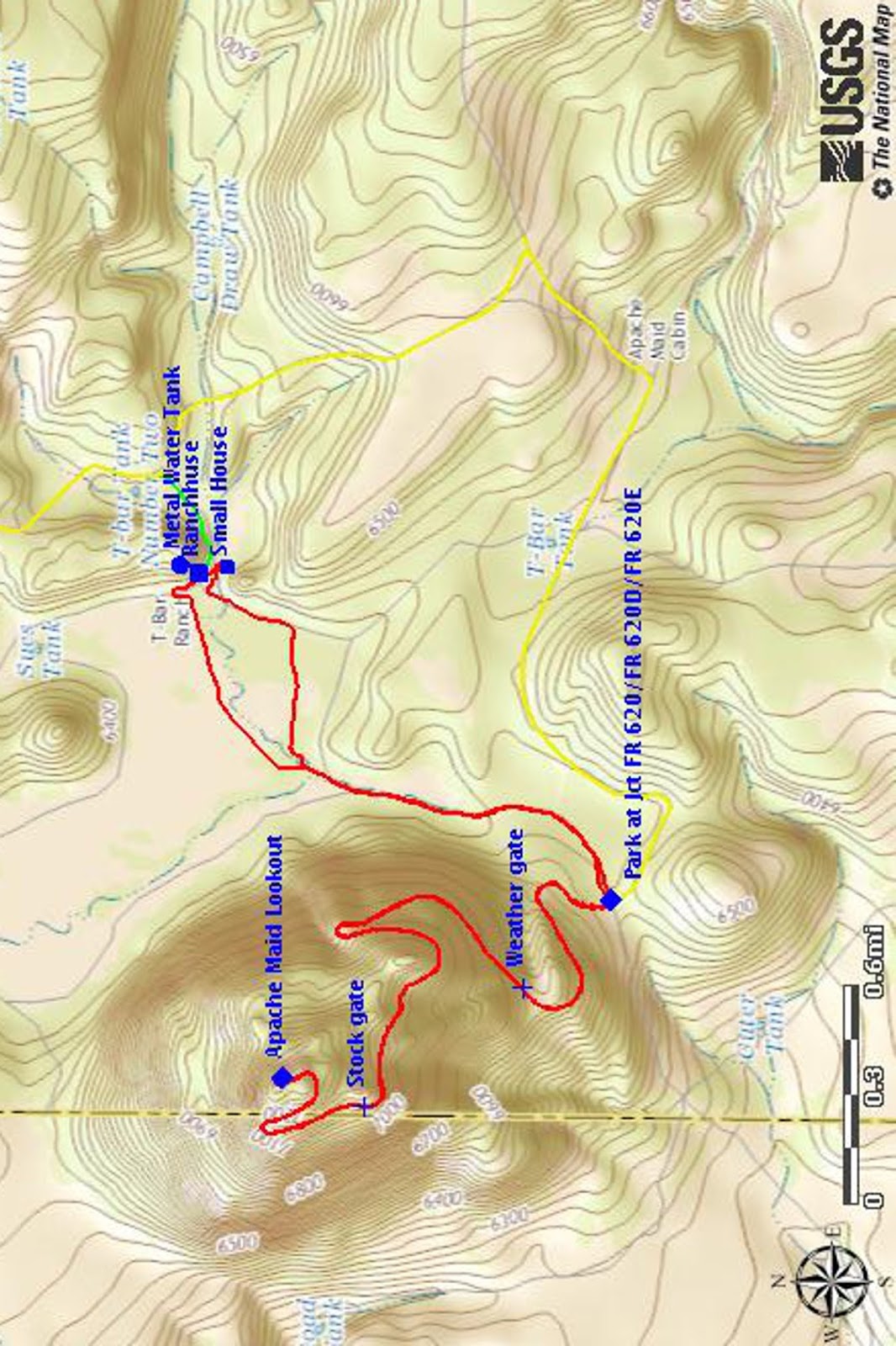
 After
the youngster had satisfied himself that he really could climb the
tower and the rest of his family descended, we decided it was time to
do the climb ourselves. That entailed climbing three flights of
stairs with a total of 40 steps. The lookout shack, built on a
platform atop the tower, had catwalks along three sides and we walked
along the south and the east sides to reach the entrance. The first
thing I saw was a small protuberance (right)
sticking out from the side of the building. It looked to me like
something that that could have been installed on the Tardis (Doctor
Who's spacecraft/time machine). The protrusion could have easily
been a rheostat designed to speed up or slow down travel through time
and space. Alas, it turned out to be nothing more than an
exhaust-fan motor; we were not in for a Doctor Who adventure after
all.
After
the youngster had satisfied himself that he really could climb the
tower and the rest of his family descended, we decided it was time to
do the climb ourselves. That entailed climbing three flights of
stairs with a total of 40 steps. The lookout shack, built on a
platform atop the tower, had catwalks along three sides and we walked
along the south and the east sides to reach the entrance. The first
thing I saw was a small protuberance (right)
sticking out from the side of the building. It looked to me like
something that that could have been installed on the Tardis (Doctor
Who's spacecraft/time machine). The protrusion could have easily
been a rheostat designed to speed up or slow down travel through time
and space. Alas, it turned out to be nothing more than an
exhaust-fan motor; we were not in for a Doctor Who adventure after
all.


 Located
about 100 yards east of the above objects was a concrete
tank (right) about 12 feet long, 3 feet wide and perhaps 36 inches deep. It
reminded me of the sort of water-cooled tanks we used in East
Tennessee to keep milk cool before mechanical refrigeration was
available. We ran cool water through the tank to keep 5- and
10-gallon containers of milk cool.
Located
about 100 yards east of the above objects was a concrete
tank (right) about 12 feet long, 3 feet wide and perhaps 36 inches deep. It
reminded me of the sort of water-cooled tanks we used in East
Tennessee to keep milk cool before mechanical refrigeration was
available. We ran cool water through the tank to keep 5- and
10-gallon containers of milk cool. By
the time we had finished examining the concrete tank, most of the
other visitors had departed and we practically had the area to
ourselves. As I finally approached the old log house, I noted what
appeared to be foundation ruins from two additional buildings that
once existed along the slope of the ridge east of the house itself.
There were also piles of wire and other scrap material (left)
that might have been the remains of old buildings and corrals.
By
the time we had finished examining the concrete tank, most of the
other visitors had departed and we practically had the area to
ourselves. As I finally approached the old log house, I noted what
appeared to be foundation ruins from two additional buildings that
once existed along the slope of the ridge east of the house itself.
There were also piles of wire and other scrap material (left)
that might have been the remains of old buildings and corrals.


 Affixed
prominently to the wall on the front porch we saw an Archaeological
Site notice (right) informing
us that the site is protected by Arizona Site Stewards.
Someone has scrawled the words “Apache Maid Ranch Homestead”
across the top of the notice. A number is provided to report
vandalism and, after trying several other sources for information on
the site, I called that number. It connected me to Arizona Game and
Fish where a representative told me that they have no information on
archaeological sites; their only role in the matter is to call the
appropriate law enforcement authorities when vandalism is reported.
Affixed
prominently to the wall on the front porch we saw an Archaeological
Site notice (right) informing
us that the site is protected by Arizona Site Stewards.
Someone has scrawled the words “Apache Maid Ranch Homestead”
across the top of the notice. A number is provided to report
vandalism and, after trying several other sources for information on
the site, I called that number. It connected me to Arizona Game and
Fish where a representative told me that they have no information on
archaeological sites; their only role in the matter is to call the
appropriate law enforcement authorities when vandalism is reported.

 Another,
smaller, house of frame construction (right)
was situated about 120 yards away, just across the streambed running
down Rocky Gulch. The house had been wired for electricity and, as
Chris noted, we “speculated as to the source of electricity and
concluded that a generator was most likely the source because there
was no evidence of power lines or poles.”
Another,
smaller, house of frame construction (right)
was situated about 120 yards away, just across the streambed running
down Rocky Gulch. The house had been wired for electricity and, as
Chris noted, we “speculated as to the source of electricity and
concluded that a generator was most likely the source because there
was no evidence of power lines or poles.”