The
drive across the Aqua Fria National Monument to Squaw Creek Pueblo
Ruin is on a dirt road that is best avoided in wet weather. We had
canceled the previous week's hike due to bad weather and I had
anxiously watched the weather forecast all week. The weather
cooperated and we experienced four sunny days preceding the day of
our planned hike, itself a fifth sunny day. The road would be dry
and hiking conditions good, so it was with great anticipation that
fourteen Skyliners left Cottonwood on 16 February 2013 to visit Squaw
Creek Pueblo and view the rock art (a lot of petroglyphs along with a
few pictographs) located on the cliff wall below the ruins.
Leaving
Cottonwood, we drove to Camp Verde and took I-17 south to Bloody
Basin Road. This road apparently begins as County Road 172 but
becomes BLM Road 9269.
This
intriguing name, Bloody Basin, of course elicited a discussion as to
its origin. Some thought it came from fighting between cattle
ranchers and sheep ranchers, some from the dull red color of some of
the rocks in the area.
My
favorite explanation is from AZCentral.com
which says that, “Bloody
Basin ... got its name from a fight between the Army and a band of
Apaches1....”
This AZCentral.com quote apparently refers to the 27 March 1873
Battle on Turret Peak which occurred during the Tonto Basin Campaign
against the Apaches, commanded by General Crook. Captain George
Randall of the 23rd
Cavalry led a punitive expedition against a band of Tonto-Apache
Indians in retaliation for the killing of three men, one of whom was
taken alive and tortured. The troops slaughtered 26 Indians at
Turret Peak. According to The
Natural American,
“It was Crook's Tonto
Campaign, and more specifically the Battle at Turret Peak, that
resulted in the name "Bloody Basin" being given to this
locale2.”
From
the I-17 exit we drove eleven miles on Bloody Basin Road, passing the
turnoff to Horseshoe Ranch at around five miles and fording the Aqua
Fria River on a concrete pad after about another two-tenths of a
mile. County maintenance of Bloody Basin road ends at the ranch and
we were then on the somewhat rougher, but still easily passable, BLM
Road 9269. The turnoff to BLM 9014, leading toward our goal, is
marked by a small road number marker, but more prominently, by a BLM
information kiosk.
We
traveled south on BLM 9014 (which changes to FR 14 when the road
crosses into Tonto National Forest after 2.4 miles) for 2.8 miles
before turning left at Tank Creek to continue south, still on FR 14
for another 1.6 miles. At this point, we parked our cars to start
the hike at a gate which marks the turn onto FR 610.
 |
We parked here and hiked southwest on FR 610 (gate is normally kept closed)
|
We
hiked on FR 610 for only about 0.4 miles before it veered to the
right while we continued to the southwest on what was now FR 599
(unsigned). We followed this road for 2 miles before turning to the
southeast on FR 3164 (unsigned). From there it was another 0.7-miles
to the main ruin on the canyon wall overlooking North Fork Squaw
Creek. However, there is a smaller ruin located about a quarter of a
mile from FR 599 and we stopped to look at that and take a group
photograph before continuing on to the main ruin.
 |
Left to right (kneeling): Colleen Maktenieks, Daisy Williams, the author and Dolly Yapp; (standing):
Donna Goodman, Kwi Johnson, Anita Jackson, Miriam Sterling, Lila Wright, Jim Manning, Frank
Lombardo, Laurie Sudol and Mark Purcell – photograph by the fourteenth hiker
|
The
ruin itself, not very noticeable from the road, was marked by a
number of deteriorated rock-walled structures.
 |
Small ruin located about half a mile from the main Squaw Creek Pueblo Ruin
|
The
road took us to the southwest end of the ruin which is spread out
atop the canyon wall above the North Fork of Squaw Creek. The canyon
at this point runs in the northeast-southwest direction. Looking
directly east, the creek was visible some 700 feet below. The
primary route to access the petroglyphs, located along the face of
the canyon just below the rim, is by way of a faint trail leading
down from this point. However, the rock art is spread out along the
rim both ways from that point. Most of them are along the
northeastern section; however a few, including some pictographs are
located to the southwest of the ruin. The result is that if one
descends at this point, it is necessary to retrace ones path in order
to see all of the petroglyphs.
 Not
wanting to retrace my steps along the wall below the rim, I elected
to go through the ruin and descend at the northeast perimeter. I
would then travel all the way along the rim past the colored figures
and return to the rim by way of a hole in the cliff wall that I had
used previously. The rest of the group descended along the
traditional path as shown in the photograph (right).
Not
wanting to retrace my steps along the wall below the rim, I elected
to go through the ruin and descend at the northeast perimeter. I
would then travel all the way along the rim past the colored figures
and return to the rim by way of a hole in the cliff wall that I had
used previously. The rest of the group descended along the
traditional path as shown in the photograph (right).
As
I hiked through the ruin, I saw that it was much the same as the
smaller one where we had stopped for a photograph, just more
extensive. The structures, as can be seen in the photograph (left)
were all of the pit-house style with the plentiful rocks in the area
used as walls and to extend the buildings above the dug out pits.
I
found it to be relatively easy going as I made my way, sans pack
which I had shed upon arrival, through the maze of old deteriorated
structures, and I was soon at the northeast corner and ready to
descend. At the right edge of the below photograph you can see the
end of the steep cliff wall that protected the people living in the
ruin above from attack by way of the canyon. My path to view the
petroglyphs would follow along below the cliff wall, all the way past
the ruin, on past the colored drawings and to the hole by which I
would ascent back to the rim.
 |
Descending from the northeast end of the ruin to view the petroglyphs
|
My
trek along the canyon wall would be about 0.3 miles. Most of the
petroglyphs were located in the first third of the trip; the colored
drawings were in the second third; the last third was primarily to
avoid retracing my path, but also because I really wanted to climb
through the hole in the rim to return to the top.
The
petroglyphs are numerous along the wall directly below the ruin and
the following photographs represent just a small sample of them. I
will just present the drawings here, leaving identification and
commentary to more qualified persons.
 |
The first drawing I saw on this trip
|
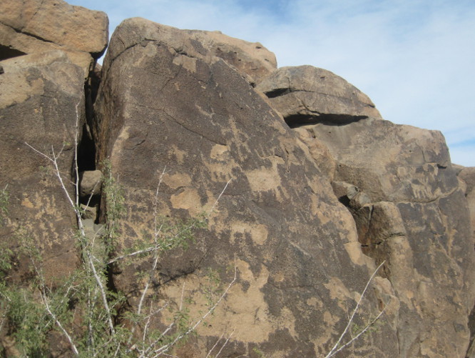 |
Miscellaneous drawings
|
 |
More miscellaneous drawings
|
 |
More miscellaneous drawings
|
 |
More miscellaneous drawings
|
 |
More miscellaneous drawings
|
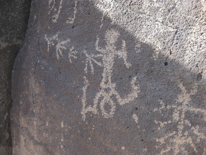
Soon
enough I was past the main ruin and closing in on the colored
drawings (more properly called pictographs). I am told that these
differ in that Petroglyphs are formed by removing the patina formed
on rock by wind and rain and sculpting and carving the rock beneath,
while pictographs are drawn or painted onto a rock surface and
require no sculpting, carving or engraving3.
The below photograph shows two pictographs seen on the cliff wall
just below the rim and a bit southwest of the main ruin above North
Fork Squaw Creek.
 |
Pictographs scattered among the petroglyphs at Squaw Creek Pueblo Ruins
|
 There
were only a few scattered petroglyphs beyond the pictographs and,
seeing nothing to distinguish them from those already photographed,
I did not bother with them, but headed straight for the hole in the
rim (right)
through which we would climb to the top.
There
were only a few scattered petroglyphs beyond the pictographs and,
seeing nothing to distinguish them from those already photographed,
I did not bother with them, but headed straight for the hole in the
rim (right)
through which we would climb to the top. By
this time all save two other hikers had turned back, preferring to
retrace their path and ascend the way they had come. I climbed
through what we have referred to as the “rattlesnake” hole,
because it would seem a great place for rattlers during hot weather,
and positioned myself to take a picture of Colleen as she emerged
(left).
By
this time all save two other hikers had turned back, preferring to
retrace their path and ascend the way they had come. I climbed
through what we have referred to as the “rattlesnake” hole,
because it would seem a great place for rattlers during hot weather,
and positioned myself to take a picture of Colleen as she emerged
(left).
The below blow-up of a section of my GPS track shows my path along the face of the cliff (green
track),
the location of the main ruin (red
diamond),
the approximate location of the pictographs (green
diamond),
“rattlesnake hole” (green
pin)
and the path along the top of the rim (blood
red track).
 |
| Track along the rim and approximate location of pictographs |
The
following map (below)
shows our track from I-17 to Squaw Creek Pueblo Ruins. Bloody Basin
Road is shown in (red),
BLM 9014/FR 14 in (green),
FR 610 (blue),
FR 599 in (dark
cyan)
and FR 3160 in (magenta).
 |
Route from I-17 to Squaw Creek Pueblo Ruins
|
1http://www.azcentral.com/travel/articles/2009/05/21/20090521azhist0522.html
2http://www.thenaturalamerican.com/bloody_basin_and_beyond.htm
3http://seethesouthwest.com/3519/what-is-the-difference-between-a-petroglyph-and-a-pictograph/
Thanks for telling everyone where this place is. Sometimes people go to these places and vandalize them.
ReplyDeleteI've been there and the free roaming cattle do far more damage grinding pottery pieces into dust than a few people taking a couple of pieces home. The self proclaimed pottery police don't have anything better to do than condemn everyone else. Get a life.
DeleteThere are dozens of places on the internet that show where these ruins are. To condemn these fine people for exploring is not called for. I admire them for getting out and doing it. It was still a free country the last I knew. But becoming less and less as the liberal politicly correct get their way to control the real freedom loving people.
Delete