Apache
Maid Lookout had been on my list of hikes to do since February 2012
when I started a hike on Apache Maid Trail at the foot of the
mountain atop which the lookout sits. I noted at the time that the
hike up the mountain and back would, if coupled with a visit to
nearby Apache Maid Cabin, make a nice day hike for the group.
Much
of the following report is predicated on quite detailed notes
provided to me by Chris Jensen.
We
left Cottonwood at 0700, drove south to Camp Verde on SR 260, turned
north on Interstate 17, exited onto Stoneman Lake Road (Forest Road
213) and drove 6.4 miles east, turned right onto FR 229 and drove 5.0
miles, turned right onto FR 620 and drove 1.7 miles to the junction
with FR 620D and FR 620E where we parked. Taking FR 620E is also the
start of Apache Maid Trail, leading to Bell Trail in the Wet Beaver
Wilderness; FR 620D leads to the old T-Bar Ranch site. We took FR
620 (below) straight ahead toward
Apache Maid Lookout.
 |
| Forest Road 620 as it starts up Apache Maid Mountain |
Today
the roads, which included the trails we hiked on, were clear and dry
and had been recently graded. Walking along a dirt road meant that
we could spend less time attending to our footing and more to the
views around us. One such view, a roadside meadow, was covered with
reddish-orange Indian paintbrush flowers mixed with the bright yellow
blossoms of groundsel (below).
 |
A roadside meadow covered with Indian paintbrush and groundsel
|

closures
We
stopped at a wide place in the road for a group photograph.
 |
| Left to right: Chris Jensen, Floyd Gardner (kneeling), the author (kneeling), Karl Sink, Betty Wolters, Jim Gibson and Lila Wright – photograph by Name Withheld |
 |
| Apache Maid Lookout |
 After
the youngster had satisfied himself that he really could climb the
tower and the rest of his family descended, we decided it was time to
do the climb ourselves. That entailed climbing three flights of
stairs with a total of 40 steps. The lookout shack, built on a
platform atop the tower, had catwalks along three sides and we walked
along the south and the east sides to reach the entrance. The first
thing I saw was a small protuberance (right)
sticking out from the side of the building. It looked to me like
something that that could have been installed on the Tardis (Doctor
Who's spacecraft/time machine). The protrusion could have easily
been a rheostat designed to speed up or slow down travel through time
and space. Alas, it turned out to be nothing more than an
exhaust-fan motor; we were not in for a Doctor Who adventure after
all.
After
the youngster had satisfied himself that he really could climb the
tower and the rest of his family descended, we decided it was time to
do the climb ourselves. That entailed climbing three flights of
stairs with a total of 40 steps. The lookout shack, built on a
platform atop the tower, had catwalks along three sides and we walked
along the south and the east sides to reach the entrance. The first
thing I saw was a small protuberance (right)
sticking out from the side of the building. It looked to me like
something that that could have been installed on the Tardis (Doctor
Who's spacecraft/time machine). The protrusion could have easily
been a rheostat designed to speed up or slow down travel through time
and space. Alas, it turned out to be nothing more than an
exhaust-fan motor; we were not in for a Doctor Who adventure after
all.
Chris,
who spent some time talking to the lookout, provided the following
input:
The man working in the tower
explained his background with state parks and the forest service and
how he passed the time in the tower. He also commented that he had
1100 visitors in the previous year.
I
stitched a panorama (below) of the
Black Hills from Squaw Peak to Sycamore Gap using several photographs
taken from the tower.
 |
| The Black Hills from Squaw Peak to Sycamore Gap |

On
the way down the hill traffic was at first quite heavy, with ATVs and
other vehicles going back and forth. But by the time we had reached
the bottom of the mountain, traffic had declined again to only an
occasional vehicle.
Back
where we started our hike we stopped for lunch and a quick nap (at
least I had a nap). Then we gathered our gear for the rest of our
planned hike. I had originally planned the hike to include a trip to
Apache Maid Cabin. This cabin was built in 1908 by ranchers Charles
Babbitt and Bill Dickison for use as a line cabin.1
The old cabin was restored in 2008 and is is now rented to the
public by the Forest Service.
However,
there is an old log house at the T-Bar Ranch site and some of the
group had identified that as being the cabin we were visiting. An
old log house did sound more interesting than a restored cabin that
would very likely be occupied when we arrived; we changed plans and
headed for the old T-Bar Ranch site. To reach it we first hiked
along FR 620D to an unnamed tank located at an intermittent stream
which flows down Rocky Gulch. I suppose that, because of its
location, it might be called Rocky Gulch Tank; but none of the maps I
referenced gave any name at all. Although FR 620D does go all the
way to the old ranch site, we chose to leave the road at the tank and
hike directly across the meadow.
On
the way along FR 620D we “passed several crowded campsites,
filled with ATVs, tents and large campers.”2
When we reached the “Rocky Gulch Tank” we found that ATV riders
had made an unofficial trail circling it and that several of them
were riding noisily round and round the tank. There were two small
humps created by construction of the tank and the riders were
apparently getting a thrill from the roller coaster-like ride they
provided.
We
quickly hurried on to leave the RVers behind, soon arriving at the
log house. There we found several other visitors who had arrived via
ATVs and pickup trucks.
Chris,
among the first of our group to reach the house wrote that:
A close observation showed the
building was built in stages and there was a broad porch about 8 feet
wide encircling three sides of the building. There were several
entrances to the building. Upon entering the house we encountered a
decaying wood slat floor that flexed and creaked as we walked on it.
The first room we entered contained a fireplace and an old time
photograph of three grim faced adults with one of the men holding a
baby in what appeared to be a long baptismal dress. The photograph
showed a shingled roof, instead of the present tin roof. Because of
the fireplace and what appeared to be a kitchen adjoining this room,
we assumed it be a main living space. Moving through the rest of the
house was like exploring a human body with the skin and other soft
tissue removed. We could identify different rooms because of the
skeletal remains of the walls.
Some
of us, approaching, the house from a different direction, saw two
iron fixtures that we couldn't identify planted in the ground. The
first one (below left)
was about hip high and appeared to be an iron inserted inside an iron
sheath or pipe. I couldn't tell whether the rod or shaft might once
have moved in the sheath. The second fixture (below
right), located a few yards away,
also an iron rod or shaft in a sheath, was only about 8 or 10 inches
tall. It had a key slot as is used to fix a cog or pulley to a shaft
and a large gear wheel was half buried in the ground nearby. I
wondered whether the objects might be the remains of some sort of
well pump, perhaps powered by a windmill.

sheath gearwheel
 Located
about 100 yards east of the above objects was a concrete
tank (right) about 12 feet long, 3 feet wide and perhaps 36 inches deep. It
reminded me of the sort of water-cooled tanks we used in East
Tennessee to keep milk cool before mechanical refrigeration was
available. We ran cool water through the tank to keep 5- and
10-gallon containers of milk cool.
Located
about 100 yards east of the above objects was a concrete
tank (right) about 12 feet long, 3 feet wide and perhaps 36 inches deep. It
reminded me of the sort of water-cooled tanks we used in East
Tennessee to keep milk cool before mechanical refrigeration was
available. We ran cool water through the tank to keep 5- and
10-gallon containers of milk cool. By
the time we had finished examining the concrete tank, most of the
other visitors had departed and we practically had the area to
ourselves. As I finally approached the old log house, I noted what
appeared to be foundation ruins from two additional buildings that
once existed along the slope of the ridge east of the house itself.
There were also piles of wire and other scrap material (left)
that might have been the remains of old buildings and corrals.
By
the time we had finished examining the concrete tank, most of the
other visitors had departed and we practically had the area to
ourselves. As I finally approached the old log house, I noted what
appeared to be foundation ruins from two additional buildings that
once existed along the slope of the ridge east of the house itself.
There were also piles of wire and other scrap material (left)
that might have been the remains of old buildings and corrals.
As
the house came into view across the shoulder of the ridge (below)
it was quite clear that this was not just a simple log cabin. We
could see that what had started out as a modest log structure with a
chimney at the left end had been expanded by a new addition at its
left end, meaning that the chimney was now in about the middle of the
house. The jumble of old logs extending to the left of the addition
are what remains of the upper part of a root cellar, a room partially
dug into the hillside, that would have been used for storing
vegetables.
 |
| Old T-Bar Ranchhouse |

against cliff trees
Later,
Dave Beach and I climbed the hill to the foot of the cliff to
investigate more closely. Inside the structure we found that it was
held tight against the cliff by a wire cable anchored to an embedded
iron rod (below left).
About half way between the anchoring rod and the wooden structure is
located a twist rod for tensioning the cable, thus holding the
structure tight against the cliff. Contained within the wooden
structure was what remained of an old galvanized pipe (below
right) that must once have provided
running water from the tank on the cliff to the ranch headquarters
below.

tensioning system enclosure
As to the old house itself, it was even larger than we had first assumed when just viewing it from the front. From our vantage point on the hillside behind the house, we could see that another entire wing (below) had been added to the back of the original building, resulting in a spacious L-shaped ranch home.
 |
T-Bar ranchhouse from the hillside above
|
 |
Hand hewn logs at the left; others were milled
|
 Affixed
prominently to the wall on the front porch we saw an Archaeological
Site notice (right) informing
us that the site is protected by Arizona Site Stewards.
Someone has scrawled the words “Apache Maid Ranch Homestead”
across the top of the notice. A number is provided to report
vandalism and, after trying several other sources for information on
the site, I called that number. It connected me to Arizona Game and
Fish where a representative told me that they have no information on
archaeological sites; their only role in the matter is to call the
appropriate law enforcement authorities when vandalism is reported.
Affixed
prominently to the wall on the front porch we saw an Archaeological
Site notice (right) informing
us that the site is protected by Arizona Site Stewards.
Someone has scrawled the words “Apache Maid Ranch Homestead”
across the top of the notice. A number is provided to report
vandalism and, after trying several other sources for information on
the site, I called that number. It connected me to Arizona Game and
Fish where a representative told me that they have no information on
archaeological sites; their only role in the matter is to call the
appropriate law enforcement authorities when vandalism is reported.
In
the living room was posted two old photographs. As is normal for
such old photographs, they were quite faded and the figures in them
were indistinct. I did photograph them; but they were encased in
plastic which reflected in my photographs reducing the quality even
further. Nevertheless, I have included both; a family grouping
(below left)
and two men branding a calf (below
right).

It
was suggested that the baby held by the man in the family grouping
photograph might be wearing a baptismal dress; however, in my
childhood memories of life in the 1930s, children, boys and girls
alike, were dressed in long gowns until they were walking. The two
men in the calf branding photograph are identified as Ed Thurston and
Dutch.

 Another,
smaller, house of frame construction (right)
was situated about 120 yards away, just across the streambed running
down Rocky Gulch. The house had been wired for electricity and, as
Chris noted, we “speculated as to the source of electricity and
concluded that a generator was most likely the source because there
was no evidence of power lines or poles.”
Another,
smaller, house of frame construction (right)
was situated about 120 yards away, just across the streambed running
down Rocky Gulch. The house had been wired for electricity and, as
Chris noted, we “speculated as to the source of electricity and
concluded that a generator was most likely the source because there
was no evidence of power lines or poles.”
This
“house across the streambed” was interesting to me because I had
spent much of my early childhood in such accommodations. One house
in particular was very similar. It was located on the Sharp Farm
which was itself located on Pond Creek in McMinn County, Tennessee.
The tenant house in which we lived could have been described as the
“house across Pond Creek” and up the lane. It consisted of a
living and sleeping room and a kitchen. However, unlike this house
,the one in which we lived did not have a porch. Neither did it have
running water or electricity. I thought it was just fine because it
was close to the woods where we kids spent a lot of our time.
Leaving
the small house behind, we walked through an old overgrown apple
orchard, crossed the wash (intermittent streambed) which along here
was covered with wild irises (below
left). Just across the wash from
the orchard we came upon the partly buried remains of what I think
must have been a small grain thresher (below
right).

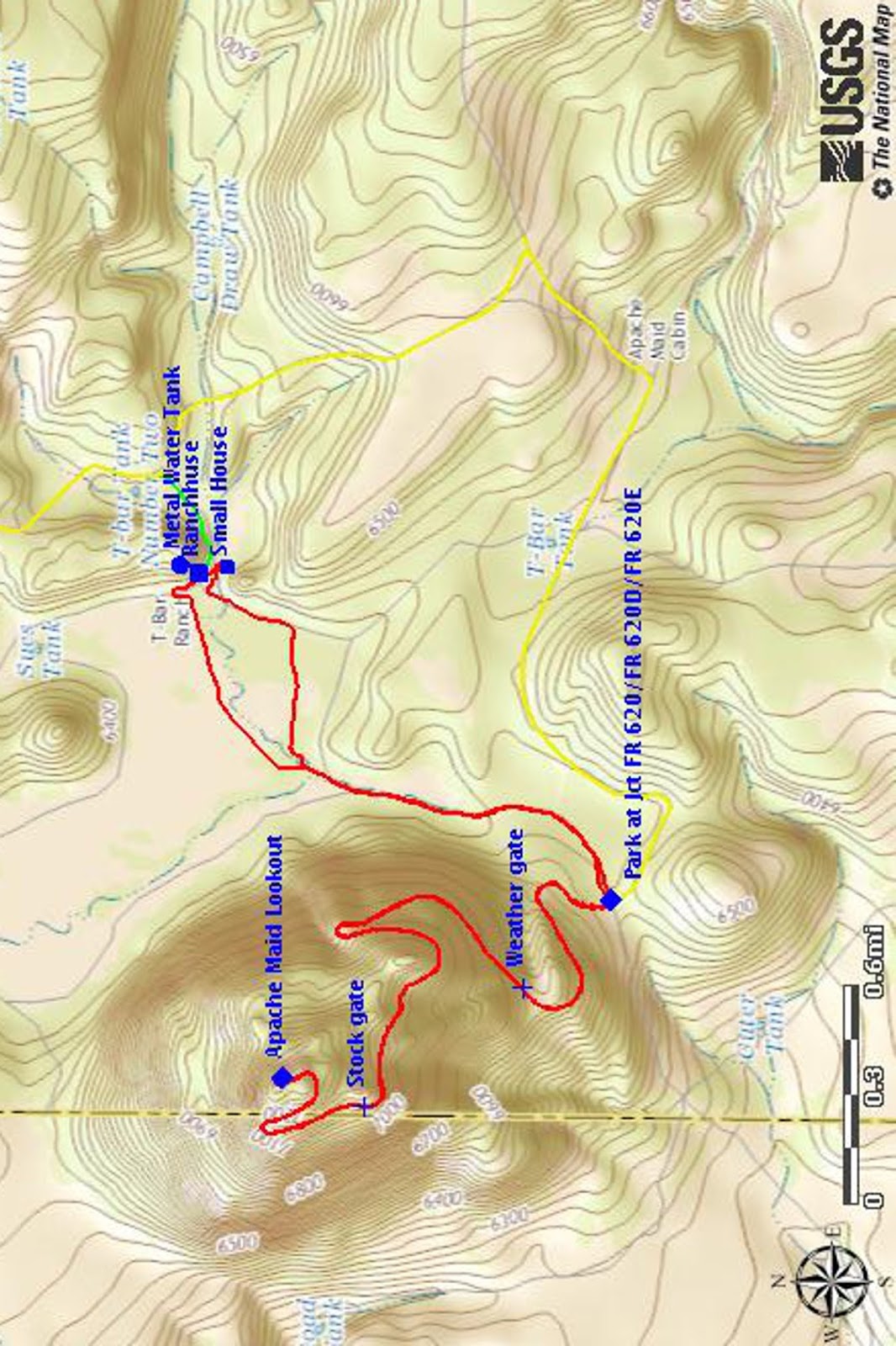
The
map (below) shows the general
layout of the old T-Bar Ranch.
The
hike to and from Apache Maid Lookout Tower and to and back from T-Bar
Ranch was 8.6 miles (total), the highest elevation was 7325 feet and
the total ascent was 1116 feet.
The
red track on the attached map (below)
shows our round-trip hike, the yellow track is part of the route we
drove from I-17 to start the hike and the short green track, partly
obscured by the labels at T-Bar Ranch, shows a section of FR 644E
that we drove for the return trip to I-17. In other words, after
finishing our hike, we drove back to T-Bar Ranch and then took FR
644E to reconnect with FR 229 for the return trip.
 |
Layout of the old T-Bar Ranch site
|
1
http://verdenews.com/Main.asp?SectionID=1&ArticleID=28319
2
From notes provided by Chris Jensen
I am looking into family history I think my family owned the T Bar Ranch! We are doing some more research.
ReplyDeleteDoes anyone know how we can look up the owner of this property site?
ReplyDeleteNo but I would love to find out!
DeleteNo but I would love to find out!
DeleteNo but I would love to find out!
DeleteCoconino National Forest system owns the T-Bar Ranch and the surrounding areas.
ReplyDelete