 Eleven
Skyliner hikers visited the Spirit Hunter Solar Petroglyph1
Site at the top of Blue Grade (Beaver Creek) Road and the V Bar V
Heritage Site at Wet Beaver Creek on 22 December 2012. To reach
Spirit Hunter, we traveled north on I-17 to the Stoneman Lake Exit,
turned east on Stoneman Lake Road and followed followed it 0.8 miles
before turning south on FR 689 (otherwise known as Blue Grade Road
and also as Beaver Creek Road). We followed FR 689 for 3.4 miles
before turning east and traveling 0.3 miles to park at a cinder pit
close to the rim of Rarick Canyon. We then hiked south along the rim
of the canyon for about 0.2 miles and descended to a ledge which we
followed (going east at this particular point) for some seventy-five
yards to arrive at the petroglyph. This route from FR 689 to the
petroglyph is shown on the map (right).
Eleven
Skyliner hikers visited the Spirit Hunter Solar Petroglyph1
Site at the top of Blue Grade (Beaver Creek) Road and the V Bar V
Heritage Site at Wet Beaver Creek on 22 December 2012. To reach
Spirit Hunter, we traveled north on I-17 to the Stoneman Lake Exit,
turned east on Stoneman Lake Road and followed followed it 0.8 miles
before turning south on FR 689 (otherwise known as Blue Grade Road
and also as Beaver Creek Road). We followed FR 689 for 3.4 miles
before turning east and traveling 0.3 miles to park at a cinder pit
close to the rim of Rarick Canyon. We then hiked south along the rim
of the canyon for about 0.2 miles and descended to a ledge which we
followed (going east at this particular point) for some seventy-five
yards to arrive at the petroglyph. This route from FR 689 to the
petroglyph is shown on the map (right).
A
faint path marks the way from where we parked to the descent from the
rim of the canyon. After a short, steep climb of about ten feet down
from the rim, we followed the rocky, cactus infested ledge close
along the rim to the solar petroglyph, crawling between the branches
of a pinon tree (left) along the
way.
Looking
straight down from the ledge we were on, we could see the dry
streambed in the bottom of Rarick Canyon. Eight-tenths of a mile
downstream is where Mullican Canyon joins Rarick, and seven-tenths of
a mile southeast (bearing 145°
true) lies the Indian Ruins we visited just over a year ago on
the rim of Mullican. However we could not see that site from here.
We
passed several other petroglyphs on our way to spirit Hunter.
 |
Petroglyphs seen along a ledge on the west wall of Rarick Canyon
|
We reached the Spirit
Hunter Petroglyph (below) shortly
after noon.
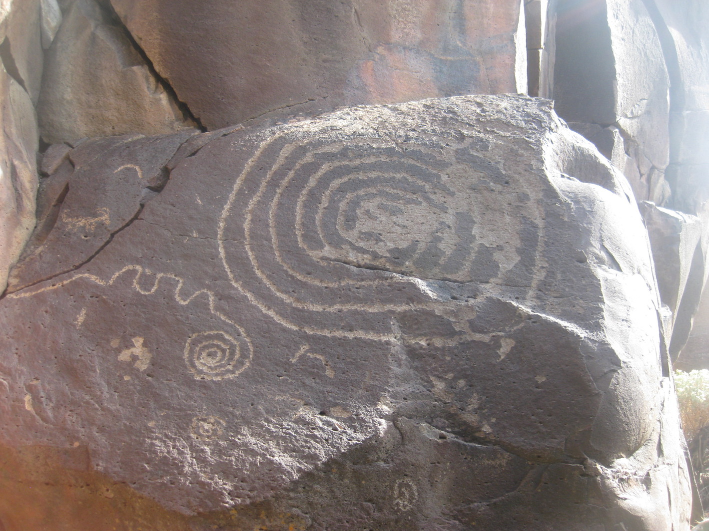 |
Spirit Hunter Solar Petroglyph
|
The
appearance of this “calendar” at significant times of the year is
illustrated at the Sinagua Sunwatchers website2.
I
scrambled several yards further along the ledge to reach a sharp
point jutting out from the canyon wall. Lila, meanwhile, had gone
back to where we descended from the rim to escort another hiker, who
had belatedly decided to descend and join the rest of the group,
along the ledge to the solar petroglyph where we would eat lunch. In
the below photograph, she is shown returning to the petroglyph, which
is hidden by the trees shown at right.
 |
Lila moving along the ledge – photograph taken from a sharp point jutting
from the canyon wall beyond the solar petroglyph
|
I
had not yet reviewed the Sinagua Sunwatchers website, so we examined
the petroglyph and tried, without much success, to decide for
ourselves what it would look like during an actual solstice. We then
perched on the sun-splashed rocks for lunch.
 |
Left to right: Dolly Yapp, Lila Wright (red jacket), Kwi Johnson, George Everman,
Colleen Maktenieks and Betty Wolters (peering around rock) – not shown are
Jim Manning, Gary Brooks, Betsy Fader and Daisy Williams
– photograph by the author
|
After
lunch, we made our way back along the ledge, climbed to the rim and
hiked back to the parked cars.
We
then decided that rather than return to I-17 for the descent to Verde
Valley from the Mogollon Rim, we would take FR 689, a well-maintained
dirt road. This road follows the rim of Rarick Canyon, passing
Watermelon and Blue Grade Tanks along the way, down into Verde Valley
and connects with FR 618. Turning east on FR 618, we followed it for
2 miles before turning into the V Bar V Heritage site at Beaver
Creek.
The
land at this site was “settled by Benjamin
Franklin Taylor and his wife, Florence Newman Taylor. Ben Taylor's
cattle were branded with the '100' brand, and the ranch became known
as the '100 Place.'"3
The
property passed through various owners until, “in
1927, James and Ida May Swift Minotto (of the Swift Meat Packing
family), along with partners, C.C. "Whitey" Montgomery and
Omer Maxwell, bought the 100 Place and a number of other small
holdings, and formed the V Bar V Cattle Company.”4
The
V Bar V brand “was
first recorded by A.W. Bradford of Flagstaff in 1907,” passed
to
“C Montgomery of Camp Verde and in 1926, it was recorded to Ida
May Swift Minotto. When the Minottos formed their cattle company in
1927, the V Bar V brand was chosen as the most simple and easy to
use.” The
brand is now owned by the University of Arizona, under which it
operates a 71,000-acre Agricultural Experiment Station.5
The
V Bar V Heritage Site, acquired by the Forest Service in 1994, is the
largest known, and one of the best-preserved, petroglyph sites in the
Verde Valley. It is said to contain more than a thousand petroglyphs
in some thirteen separate panels.
A
description of the site along with entrance fees and hours of
operation is provided on the Coconino National Forest website at:
http://www.fs.usda.gov/wps/portal/fsinternet/!ut/p/c5/04_SB8K8xLLM9MSSzPy8xBz9CP0os3gDfxMDT8MwRydLA1cj72BTSw8jAwgAykeaxcN4jhYG_h4eYX5hPgYwefy6w0H24dcPNgEHcDTQ9_PIz03VL8iNMMgycVQEAIzTHkw!/dl3/d3/L2dJQSEvUUt3QS9ZQnZ3LzZfME80MEkxVkFCOTBFMktTNUJIMjAwMDAwMDA!/?ss=110304&ttype=recarea&recid=55424&actid=119&navtype=BROWSEBYSUBJECT&position=BROWSEBYSUBJECT&navid=110355000000000&pnavid=110000000000000&cid=null&pname=Coconino+National+Forest+Recreation+-+V-Bar-V+Heritage+Site
A
spacious parking lot, is provided at the site, just 0.2 miles from FR
618. The visitors center, located alongside the creek near the old V
Bar V winter headquarters site, is just ahead. The chimney from the
old ranch house still stands, a silent witness to bygone days.
 |
Old ranch house chimney at V Bar V winter quarters
|

Examining
the chimney close up from a different angle reveals the V Bar V brand
embedded in the vine-shrouded outside structural wall (right).
After
checking in at the visitor center, we proceeded along the smooth,
packed-sand surface of the trail leading to the petroglyphs, only 0.4
miles away.
A
guide was available at the site to explain the meanings of some of
the petroglyphs and how some of them were used to determine the
seasons. Rather than try to remember his words, I will just show a
photograph of a posted explanatory sign and follow that with a photograph of the “calendar.” The
drawings thought to be significant in marking the seasons - when to
plant crops, when to hold ceremonies, etc, are highlighted in Yellow.
Look carefully and you can find them in the photograph below.
 |
| Posted explanatory sign |
 |
Petroglyph calendar at the V Bar V Heritage Site
|
The
sun shines on the wall through a cleft in the rock, as shown in the
lower right picture included on the explanatory sign (see Posted explanatory sign above) to highlight the various features pointed out in the sign. A
photograph of the cleft (see
arrow)
is shown below.
 |
Cleft through which the sun highlights various calendar features
|
The
petroglyphs shown above were, I thought, the most impressive at the site, although there are
many others to be seen.
Leaving
the V Bar V Heritage Site, we split into two groups, four of us
headed home while the remaining seven visited nearby Sacred Mountain.
Our
travels from the I-17 Stoneman Lake Exit to the Spirit Hunter
Petroglyph and on to the V Bar V Heritage Site are shown by GPS track
on the below map (below).

1Name
supplied by Lila Wright, Skyliner leader; no other reference found
2http://www.sinaguasunwatchers.com/tour/tour-3.htm
3http://cals.arizona.edu/aes/vbarv/historytimeline.html
4Ibid
5http://cals.arizona.edu/aes/vbarv/brandhistory.html
No comments:
Post a Comment