Saturday, November 27, 2010

Tomkins Trail 513


Thirteen strong, a party of Skyliners braved the 1600-foot climb on rock-strewn Tompkins Trail 513 on 27 November 2010.

Standing, left to right: Jim Manning, Linda Tovar, John MacInerney, 
Marvin Alt, Ellis Price, Name Withheld, Miriam Sterling; Sitting/kneeling: Lila 
Wright, Dolly Yapp, Kwi Johnson, Virginia Driscoll, George Everman, 
Betty Wolters - Photograph by Gorillapod, using George’s camera.
Taking group pictures has always been a bit of a tricky proposition for us; even though we have cameras with time-delay features it is not always possible to find a place to position a camera. In the past we have sometimes placed it on a backpack, a suitable rock, or even a sturdy tree branch. Now, however, we think we have solved the problem. Meet our new photographer’s assistant, the Gorillapod (right). Shown here, positioned sturdily on it’s three legs, for the above photograph, it can also wrap itself around tree branches to provide a shooting platform for a time-delay shot.

From Cottonwood, we drove to Camp Verde on Hwy 260, continued across I-17 for one and seven-tenths miles to turn right on Oasis Road. At the foot of the hill, about one-half mile from Hwy 260 and just before reaching Salt Mine Road, we turned right onto FR 136, the forest road running up Copper Canyon. We continued on FR 136 for two and one-half miles to park at the Trail 513 Trailhead, located in a sharp bend about sixty yards past a cattleguard. (NOTE: The trail marker has succumbed to vandalism and the top half, along with the trail number, is missing.)

The trail starts with a steep incline that varies little along the way except for a few very short sections until it tops out on a ridge near Tomkins Tank. (NOTE: I had previously called this trail Lucky Canyon Trail; however, I have since found it listed on a topo map as “Tomkins” Trail. That map also shows another trail running up Lucky Canyon (the canyon straight ahead of us when we topped the first ridge) to connect with the one we were following at this point, the divide between Copper Canyon and Lucky Canyon. All the maps that I have found with trail numbers do indicate that Tomkins is No. 513, so I guess we are safe to refer to it by that designation. Meanwhile, I have never been able to find where the trail running up Lucky Canyon actually connects with Trail 513.

Our trail, also used by 4-wheelers, was steep and littered with loose rock, requiring care to avoid sprained ankles. It did, however, provide great views back across Verde Valley to the San Francisco Peaks. If you are so inclined, you can also view the traffic on I-17 running up the other side of Copper Canyon.

View from Trail 513 across Verde Valley and the Mogollon Rim to the 
San Francisco Peaks beyond.
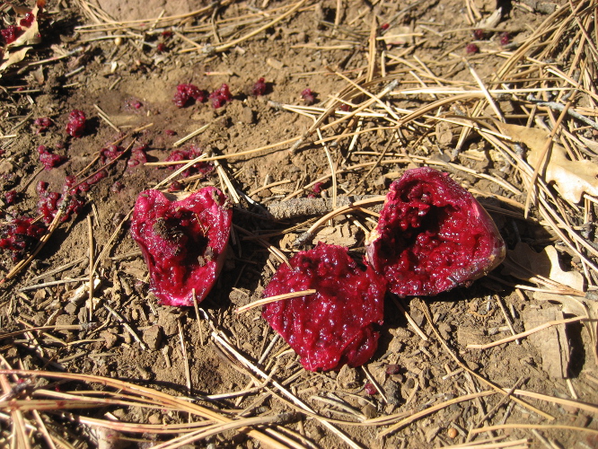
Somewhere along the trail George and Kwi found a clump of Paperspine Cactus, a species we had previously only seen at one other location. We also saw several examples of galling on the scrub oaks along the trail. See photograph (left) for two galls removed from a tree and displayed among the rocks on the trail. I have always wondered what caused this phenomenon and decided to find out. According to an entry in Wikipedia what we saw appears to be oak marble gall. The Wikipedia entry indicates that the gall provides the developing larvae with a safe refuge.1

We wound our way slowly up the trail, stepping carefully to avoid loose rocks, stopping once along the way for a snack and several times just for a breather. At last, after having climbed over 1600 feet in a distance of one and two tenths (12/10) miles, we arrived at the top of the hill. When we topped out we were two tenths (2/10) of a mile and 255 degrees true from Tomkins Tank. While most of us were resting, John and Kwi hiked out to a point we could see to our north that appeared to overlook Copper Canyon and the Verde Valley. When they returned to report that it was indeed a great viewpoint, we decided to hike to there for lunch and then head back down the trail, leaving ourselves time to visit the waterfall in Copper Canyon; the waterfall is after all very near the lower trailhead where we had parked.

Linda and Marvin are enjoying the view across Verde Valley; 
John is searching for Gold?
We all enjoyed the view and I got a good solid nap before we headed back.

Looking back down Trail 513 and across Verde Valley to the Mogollon Rim
– Photo by John
Leaving the viewpoint we made our way back to the trail. Although there was no trail to guide us back to Trail 513, the way was relatively clear of undergrowth and the going was fairly easy. A photograph by George (right) shows us straggling back lunch. It also gives an idea of the terrain through which we were hiking. We did have to stay alert to not have anyone become separated from the group as the trees were thick enough that anyone falling back more that twenty or thirty yards was in danger of losing sight of those in front.

Once back on the trail the going was easy in that it was all downhill; however, great care was required to avoid falls due to the sharp incline and loose rocks on the trail. Some found the descent harder on the knees than the ascent had been. Following is a photograph showing hikers carefully picking their way the trail. As you can clearly see each step requires care.

Descending the trail with care – Photograph by George
By the time we reached the spot where we had taken our first rest break on the way up the trail, the group had gotten scattered out and we stopped again to let everyone catch up before descending the rest of the way. As noted before this spot is on the rim of Lucky Canyon where, according to the map, a trail running up that canyon should join with Trail 513. However, I still saw no sign of it. When we had stopped here on the way up the trail, George had spent the time gathering brass, which was plentiful because the area is apparently used for target practice. Shown below are some of the shells George (with the help of Kwi and others) gathered during that first stop. I have also included a nice picture of a Hollyleaf Buckthorn.

Brass cartridges – Photograph by George
Hollyleaf Buckthorn – Photograph by George
A couple of the hikers continued on to the cars to wait, Kwi searched for more brass and then followed them, John arrived and decided to explore the immediate area, and I stretched out, pulled my hat over my face and served as a trail marker. After all, I reasoned, we didn’t want the rest of the party to pass us by without knowing we had stopped to wait.

When everyone had caught up we continued on down to the trailhead, about another four-tenths of a mile, doffed our backpacks and walked on down to the falls, just about a tenth of a mile away. The falls had a steady stream of water; however the foliage in the area was not as pretty as the last time
I was here, just one year ago. George did take a good photograph of a Squaw Bush.

Squaw Bush
The following photograph taken November 28, 2009, shows the area as it appeared then.

Taken from the top of the falls on November 28, 2009
According to my GPS our hike was five and one-tenth miles round trip and the elevation change was 1630 feet.

The included map (below) shows the GPS track for this hike.


1 http://en.wikipedia.org/wiki/Gall_wasp

Saturday, November 20, 2010

Verde River from Salt Mine Road via Ladder Trail


On 20 November 2010 fifteen hardy souls (Linda Tovar, John McInerney, Anita Jackson, Lila Wright, Kwi Johnson, Virginia Driscoll, Miriam Sterling, Daisy Williams, Betty Wolters, Dolly Yapp, George Everman, the author and three others), acting on faulty memories provided by myself and Lila, set out to hike to the Verde River from Salt Mine Road. We thought that we would reach the river at a point slightly above the Verde River Falls. As it turned out we reached the river almost a mile (about half a mile as the crow flies) below the falls.

As to how we actually reached the river, both Lila and I recognized the turnoff from Salt Mine Road onto the gated road leading toward the river. However, most of what we remembered after that was either wrong or changed. We both remembered having to leave the rough road and clamber down a wash to reach the river. What we actually found this time was that if we turned right when the road forks about one and four-tenths of a mile from the gate and continued for another seventh-tenths of a mile the road would end at the top of a bluff overlooking the river. From there Ladder Trail #16 leads steeply down the bluff to the river, descending 250 feet in a tenth of a mile. I paused to take a picture looking upstream from the trail.

Looking upstream along the Verde River from Trail 16
On reaching the bottom of Trail 16 and still believing ourselves to be upriver from the falls, we turned downstream to see whether we could reach them before lunchtime when we intended to turn back.

Just a few yards downstream from the trailhead we found an old mine tunnel in the face of the cliff. We entered and discovered that it ended just thirty feet in. It would have made a great shelter except that it was a little close to the waterline for comfort. Although I saw no signs of water having entered recently, I thought that it might happen during extreme flooding conditions. Other than some rat droppings and a single bird nest on the ceiling, the tunnel held little of interest to us.

Opening to old mine tunnel
Nest on ceiling of mine tunnel
Continuing on down the bank of the river, we came first to a cable strung across the river high up on the cliff walls to carry a car back and forth (below). The reason for the cable car was unclear as there seemed to be absolutely nowhere to go once the car reached the sheer cliff wall on the other side. A bit farther along we passed a water gage system, installed with a solar panel and an antenna to transmit readings (below).

Aerial Cable Car
Water gage system
Approximately three-tenths of a mile from the trailhead we passed the mouth of the canyon carved by Chasm Creek and continued for about as far again before deciding to give up on finding the falls and stop for lunch. We ate lunch just across the river from Sycamore Canyon.

Although we were disappointed that we hadn’t reached the falls, it was time to turn back after lunch and we started back upriver. Along the way we spotted what appeared to be a large wooden ladder positioned against the canyon wall. As with the cable car, we never determined it’s purpose. We assumed that both structures might have something to do with observing Bald Eagles, as we were in a nesting area. A bit later George spotted a group of River Otters frolicking in the water; unfortunately they were gone before he could unlimber his camera. In the same area, he discovered some tracks that we could not identify. The pad resembles a dog track (photograph by George at right), however, this critter also had long, scary-looking claws.

The trip upriver seemed a lot longer than our trip down the river had been, and after a while we seemed to be struggling through dense undergrowth that we had not encountered on the way down. Finally, we stopped and with reference to a GPS found out why. We had overshot our mark by about four-tenths of a mile. We had all been convinced that we could not possibly fail to see either the mineshaft near the lower end of Trail 16 or the gate that marks the end of the trail. But we did. We promptly turned around and headed back, this time keeping a close check on the GPS. Even though, it marked the beginning of a steep 250-foot climb back to the road at the top of the bluff, we were all very happy to finally see the green gate that marked our trail.

In consideration of the misadventures experienced on this hike, and thinking we might want to do it again in the future, I have taken special care to record our hiking route. Also because even finding the beginning of the hike at Road 9039R presented a bit of a problem, I will provide detailed directions to that point. To reach Road 9039R at Salt Mine Road, take Hwy 260 to Camp Verde and start marking the mileage at I-17. Continue on Hwy 260 for one and seven-tenths miles and turn right onto Oasis. Follow Oasis for one-half of a mile to the bottom of the hill and turn right onto Salt Mine Road. Follow Salt Mine Road for six and three-tenths miles until you come to the end of the pavement. (NOTE: The paved road makes a sharp turn to the left at this point, but that is NOT Salt Mine Road). Continue straight ahead on Salt Mine Road (also marked as FR 574), now a dirt road. One mile ahead, Salt Mine Road, continues straight when FR 574 forks off to the right. Continue for another two and four-tenths miles to arrive at the gate that provides access to Road 9030R. Parking alongside the road is available for several cars. Actually, with a high clearance vehicle, pickup or 4-wheel drive, you could drive all the way to the beginning of Ladder Trail #16.

Somewhere along the way, George talked Dolly into doing a dance to appease the Trail Gods.

Dolly doing the trail dance
I questioned the efficacy of the dance, but someone pointed out that we had all returned safe and sound.


Saturday, November 13, 2010

Yaeger Canyon Loop Hike


Eight Skyliners (Anita Jackson, George Everman, Lila Wright, John McInerney, Ellis Price and three others) hiked the Yaeger Canyon Loop, using Trail 28, Trail 111, FR 105 and Trail 533 on Saturday, 13 November 2010.

We drove through Jerome on Hwy 89A, crossed over the Summit of Mingus Mountain and parked alongside the road at about mile marker 333.1. The parking area is on the left as you travel south on 89A and is located just at the end of a guardrail. An old road, now blocked off with large rocks, leads down from the highway just at the end of the guardrail.

The start of Trails 28 and 533
We walked past the rocks and were confronted with a choice: we could continue straight ahead on Trail 533 or turn to the left and take Trail 28. To complete the loop, one hikes up the canyon on one of these two trails and returns on the other. We chose Trail 28 for the ascent, and hiked the loop clockwise, because that trail has a lot of loose rock and would be harder to descend on. Trail 533, on the other hand, has a much better surface for a descent.

We paused along the trail while George positioned his camera and set the time delay for a group shot. The below photo was taken a bit more than a mile from the trailhead.

Trail 28 parallels 89A for approximately half a mile, passing by the remains of a bridge that once served the old highway. Just beyond the old bridge, the trail turns eastward and begins to climb, switchbacking up to the head of a side canyon. We paused on one of the switchbacks for the group photo shown above. As you climb the steep, rocky trail, Prescott Valley comes into view below and Hickey Mountain can be seen to the west. The trail passes below a large rock bluff and then ascents to cross at the top of a smaller one. This is a good place to pause and climb out on the bluff for a rest and a bird’s eye view of Prescott Valley. A craggy, gnarled old dead tree stands at the edge of the bluff.

Taken along Trail 28 at the top of a rock bluff and at a good viewpoint.
On the trunk of the dead tree, we found wonderfully intricate patterns, probably carved by Mountain Pine Beetles. At first no one had any idea what had caused the patterns; however, I later found a Forest Service publication1 showing similar damage attributed to Mountain Pine Beetles, and assume they also caused the pattern shown in the photo shown below.

Mountain Pine Beetle carvings (I think) –Photo by George
Someone had left the remains of a rose bouquet atop the bluff, perhaps from a wedding held there. We speculated as to whether Grandma was able to make the ceremony if someone really did get married there. Then we looked around and realized that most of us were probably Grandma’s contemporaries. The rose bouquet was just too bedraggled for a good picture; instead I took a picture of a perfectly formed pincushion cactus growing atop the bluff.

Hedgehog cactus
Looking back from farther up the trail we could see the bluff with the dead tree.

Bluff with dead tree in center, Prescott Valley in the distance, author in 
right lower corner– photograph by George
View from near top of Trail 28. Looking across Prescott Valley. Hwy
89A is lower right
Nearing the intersection of Trail 28 with Trail 111, we paused for a snack under a great old Alligator Juniper. George had gathered some Prickly Pear fruit along the way; some of us sampled it and were rewarded with bright red fingers and lips, not to mention stickers in our fingers.

Cactus fruit
Hikers enjoying a snack
About two tenths of a mile, perhaps a bit less, from our snack break at the Alligator Juniper, we came to the junction with Trail 111. I checked later on Google Earth and found that had we continued straight ahead instead of turning on Trail 111, we would have arrived at FR 413 in less than four tenths of a mile.

Along the way we found bear scat (we think) and an arrowhead.

Bear scat (we think) - Photo by George
An arrowhead (shank broken off) – Photo by George
Taking Trail 111 at the intersection, we traveled generally southeast, angling toward FR 413. About three tenths of a mile from the intersection with Trail 28, we actually came within 110 yards of FR 413 before the trail turned to the southwest to run parallel with. Meanwhile, John had noted a spring (Young Seep Spring) shown on the topographic map and wanted to see if we could find it. I thought it was probably not much as the name itself seemed to imply that it was merely a seep. However, we came to it just before Trail 111 turned to the southwest, and it turned out to be quite impressive for a seep; it fed a nice patch of grass and ice from the night before was still present.

Young Seep Spring – John is shown standing on the other side 
– Photo by George.
We continued along Trail 111, traveling a total distance of around one and eight tenths of a mile from Trail 28, to arrive at FR 105. We then followed FR 105, going west, slightly south, for a bit less than 300 yards to arrive at the Trailhead for 533. We followed Trail 533 through the forest for about one quarter of a mile before coming out in a sunny area at the head of the canyon; we stopped there to eat lunch before heading down. I grabbed a quick lunch, drank a cup of tea and settled in for my noon nap. When George woke me up all the others had gone ahead, saying that it was just cold to sit still. Perhaps my resting spot was more sheltered; I was quite comfortable. George and I soon caught up with the rest of the party and we all arrived back at the trailhead together.

The hike was 6.8 miles long with an elevation change of 1475 feet (7205 minus 5730).

Our GPS track is shown on the included map (below).


Saturday, November 6, 2010

Telephone Trail


Nine hikers from the Skyliners group hiked on Telephone Trail #72 in Oak Creek Canyon on Saturday, 06 November 2010

We drove through Sedona on Hwy 89A and parked alongside the road about a tenth of a mile beyond mile marker 385. From there we hiked a bit less than a tenth of a mile further to reach the trailhead. Contrary to what we had been led to believe, parking was not a problem; even though it was almost 9 AM on a Saturday morning. It should be noted, however, that when we completed the hike around 3 PM, the area parking was at a premium.

The trailhead is fairly well marked (right - photograph by George), although one must know where to look and be alert to avoid missing it.

The trail runs up the canyon, parallel to the highway for just over a tenth of a mile before turning sharply up the canyon wall. This area of the forest has recently been thinned, and the workers apparently appropriated a section of the trail for use during this operation. Unfortunately, where the work trail leaves Telephone Trail, it is now much more obvious than the original trail, and we made the mistake of continuing on the work trail at this point. 

After a while, finding that we were circling back down the slope, we turned back to intersect Telephone Trail near the point where we had left it. This side trip is included in the round trip hiking distance given in this report and is shown separately, in green, on the attached Google Earth map.

Just over half a mile from the trailhead (not counting our side trip on the work trail), we came out on top of a sharp ridge with a view down the other side into another side canyon. We stopped here for a snack before continuing southeast along the trail, which ran just below the crest for a distance, then crossed over and followed the other side of the crest to a sharp narrow ridge of rock that formed the spine of the ridge crest at that point. This section of rock (left) has several windows (or peepholes, as some call them) through which one can look through back down into Oak Creek Canyon. Several pictures of these windows are shown below.

Window in rock crest of ridge
Window in rock crest of ridge – tree beyond
The trail leads between the tree and the windows
 

View of Oak Creek Canyon through the window  – by George Everman
Kissing rocks at top
The section of trail between where we had stopped for a snack and the window rocks was fairly easy, following at generally the same level along the ridge spine. Soon after passing the window rocks, however, the trail, still following along the ridge between side canyons, grew sharply steeper and was a bit difficult to follow in places. Fortunately, wrong turns soon became apparent and we never had to retrace our steps more than a few yards. A rock formation known as the “Baby Carriage”came into view as we continued our climb. To me it looked more like Albert the Alligator, from the old Pogo comic strip, with Pogo the Possum astride his neck, than a baby carriage.

The Baby Carriage 
although I still see a Possum (Pogo) riding an Alligator (Albert)
Not more than two tenths of a mile of steep climbing from window from the rocks we came to what we decided must be the end of Telephone Trail on top of the canyon rim. Although there were signs of old roads in the area, we found no discernible trail beyond this point, and stopped here for lunch. We were approximately one mile from the trailhead on Hwy 89A.

After lunch for everyone and a quick nap for me, we walked on along the rim in a generally southwest direction for about two tenths of a mile. We had some discussion about continuing along the rim and descending by way of the Thomas Point Trail. However, we were uncertain how difficult it would be to find the start of that trail and decided to return the way we came, putting off a Thomas Point-Telephone Trails Loop for another day.

Climbing the trail had been difficult due to the steep gradient; traveling back down, while much faster and easier, presented difficulties of its own. I heard several hikers say that it was much harder on the knees than the climb up had been. But we all made it in good condition and paused at the lower trailhead for a group photograph.

We also had a great view of Mount Agassiz framed by trees as we approached the top of the trail.

Magnified view of Mt. Agassiz framed by trees
Left to right: Daisy Williams, John McInerney, Linda Tovar, Betty Wolters,

George Everman, Miriam Sterling, Name Withheld, Donna Goodman 
– Photograph by the author
The total hiking distance was just about four miles. That includes a short hike from where we parked to the trailhead, the work trail hike that we inadvertently took, and the extra four tenths of a mile we hiked along the rim after lunch. The elevation change, according to my GPS file was about 1370 feet.

The GPS track for this hike is shown on the included map (below). Telephone Trail is shown in red; the yellow track shows where wandered along the rim.