Ten
Skyliners hiked in the Willard Springs area, between Interstate 17
and Oak Creek Canyon, on 19 October 2013. We call this hike, mostly
along Forest Service roads, the Willard Springs Loop. It is a rather
short hike with little elevation change, perfect for a day when you
want to hike, but really don't want to put a lot of effort into it.
We
took I-17 north to Exit 326 and turned west on Forest Road 253 which
we followed for 2.1 miles before parking at the junction with FR
9497. From there, we hiked for 1.0 mile along FR 9497 before turning
off the road and continuing southwest through a relatively open
forest for 0.4 miles to connect with FR 9498 which we followed all
the way to the upper Thomas Point Trailhead, our planned lunch stop.
 Along
the way we saw a number of beautiful bright yellow flowers (right)
which George Everman later identified as showy goldeneye. This
seemed to be the season for it because we found others wherever the
trees thinned and allowed grass to grow.
Along
the way we saw a number of beautiful bright yellow flowers (right)
which George Everman later identified as showy goldeneye. This
seemed to be the season for it because we found others wherever the
trees thinned and allowed grass to grow.
As
we neared the Thomas Point Trailhead we came to an opening which
allowed us a view across Oak Creek Canyon to the white cliffs on the
other side.
 |
View across Oak Creek Canyon from Thomas Point
|
This seemed a good spot
for a group photograph, so we posed on the rim of the canyon.
 |
Left to right (front row): Betty Wolters, Kwi Johnson, Dolly Yapp, the author;
(back row): Lila Wright, Connie Woolard, Daisy Williams, David Beach
and Miriam Sterling – photograph by Name Withheld
|
 The
old road we were following continued on past this point for a short
distance to end at a man-made rock wall (left),
seemingly serving no other purpose than perhaps to mark the Thomas
Point Trailhead. In any case, that is what I have always used it
for. The point is just a hundred yards or so wide at this spot and
when I turned from taking the photograph of the wall, I had to walk
only a few yards for the following terrific view of Oak Creek Canyon
looking toward Sedona.
The
old road we were following continued on past this point for a short
distance to end at a man-made rock wall (left),
seemingly serving no other purpose than perhaps to mark the Thomas
Point Trailhead. In any case, that is what I have always used it
for. The point is just a hundred yards or so wide at this spot and
when I turned from taking the photograph of the wall, I had to walk
only a few yards for the following terrific view of Oak Creek Canyon
looking toward Sedona. |
Looking down Oak Creek Canyon toward Sedona from Thomas Point
|
 Intrigued
by the scattered spots of fall color in the above photograph, I
zoomed in for a closer view (right)
of one particularly noticeable area showing a range of colors.
Intrigued
by the scattered spots of fall color in the above photograph, I
zoomed in for a closer view (right)
of one particularly noticeable area showing a range of colors.
It
was just a little after 1100 and we normally don't stop for lunch on
our hikes until 1200. But we would not find a better viewpoint
anywhere on this hike, so we ate early and enjoyed the view.
As
we were departing the point, I paused for a final look at the San
Francisco Peaks prominent on the distant horizon.
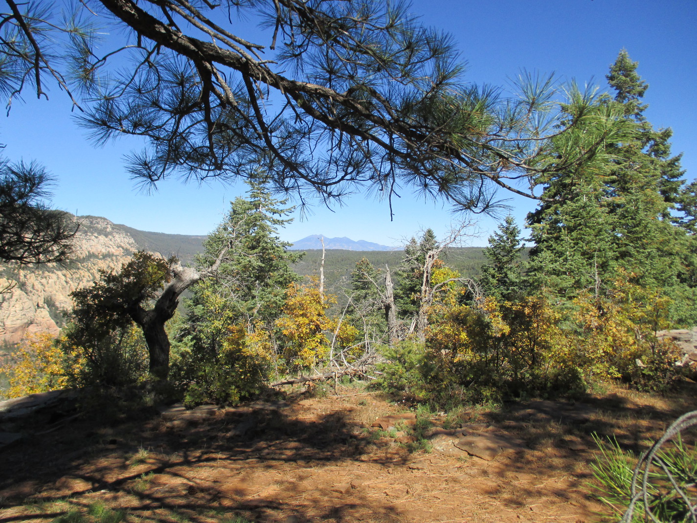 |
The San Francisco Peaks seen from Thomas Point
|
On
the return hike we saw, along with many more of the showy goldeneye
flowers, a few asters and an isolated Indian paintbrush.
 |
Clump of asters
|
 |
Indian paintbrush
|
The oak trees scattered
along our trail were in formal fall dress, proudly showing off their
colors among the green conifers.
 |
Oak trees in seasonal color among the conifers
|
Farther
along the trail, we saw entire meadows peppered with showy goldeneye
flowers.
 |
Meadow peppered with showy goldeneye flowers
|
We
arrived back at our parked cars at 1330, a few minutes over fours
from the time we started the hike.
According
to my GPS, the hike distance was 5.4 miles, the total ascent was 523
feet and the highest elevation was 6703 feet.
The
map (below) shows the hike to
Thomas Point in red and the return trip in blue. Where the tracks
are coincident only blue is visible.

No comments:
Post a Comment