This
report on Woodchute Trail is based on three separate hikes: a hike on
the north end of the trail on 16 May 2009, a hike of the entire trail
on 17 July 2008 and a hike on the south end of the trail 4 May 2013.
The below photograph shows the most recent group of hikers.
 |
Left to right: Daisy Williams, Anita Jackson, Lila Wright, Kwi Johnson
and Betty Wolters – photograph by unnamed hiker
|
To
reach the south end of Woodchute Trail from Cottonwood, the 4 May
2013 hikers drove south on Hwy 89A through Jerome and continued on up
the mountain to the top of Mingus. At the summit, they turned right
on the paved road to Potato Patch Campground and traveled about 0.30
miles before turning left on another paved road. The pavement ended
at a roughly circular area with toilet facilities. They continued on
through this area going generally northwest on a dirt road for about
0.70 miles to arrive at the Woodchute Trailhead parking area.
The
May 2013 hikers chose the south end of the trail because they still
remembered the steep climb up the north face of Woodchute from the
2009 hike. George Everman and the author hiked the entire trail in
2008, placing a vehicle at each end and hiking south to north.
From
the south trailhead the trail leads a short distance to the northeast
and then turns north to follow along the spine of the ridge. At
first it follows parallel to Hwy 89A, occasionally seen (or at least
heard), about a tenth of a mile and 400 feet below. The drainage
from the ridge is into Martin Canyon on the west and Mescal Gulch (at
first) and then Deception Gulch on the east. For approximately the
first 0.8 miles the trail follows along just below the crest on the
east side; it then follows along the crest so that one can see down
into Verde Valley to the east and Chino Valley in the west. Another
mile or so brings you to Woodchute Tank and the junction of Trail 104
leading down into Martin Canyon to join with Trail 103. The trail
elevation along this section ranges from around 7130 at the trailhead
to 7325 along the crest and then drops back to around 7250 at
Woodchute tank, an easy hike.
Somewhere
along the way, the hikers on 4 May 2013 found a metal lizard fixed firmly to a juniper tree. Someone had certainly put a lot of
effort into forming this object and attaching it to the tree. I
think it is of fairly recent vintage, as I did not see it when I last
hiked this section of trail as part of the Martin Canyon/Woodchute
Loop in 2009.
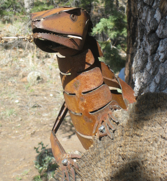 |
| Metal lizard |
The
following photograph was
taken looking west from the Trail 104/102 (Woodchute Trail) junction
near Woodchute Tank.
 |
Looking west into Chino Valley from the Trails 104/102 junction
|
On
reaching Woodchute Tank, the trail starts to climb fairly steeply,
rising another 400 feet in the next mile to the top of Woodchute
Mountain. Once it reaches the relatively flat top of the mountain,
the trail follows closely along the contour at an elevation of around
7650 feet, then gently drops to about 7500 feet to start the descent
on the north end of the mountain. But our hikers do not intend to go
that far; their goal is the Verde Valley overlook near where an old
wooden chute once provided a short path off the mountain for the logs
harvested on top of Woodchute for use in the mines at Jerome.
Unfortunately,
upon arrival at the view point they found not much of a view as the
valley below was shrouded in a heavy haze. Disappointed, they hiked
along the rim past the location of the old wood chute to check the
view to the north and found it little better. It was just not a good
day for viewing things at a distance. Having already hiked some 3.8
miles, they returned to the main trail and headed back the way they
had come, stopping along the way for another view of the metal
lizard.
 |
Another view of the metal lizard
|
The
hike on 4 May 2013 was 7.6 miles round trip with an elevation
difference of 535 feet.
Nine
Skyliners hiked the north end of Woodchute on 16 May 2009. They took
Hwy 89A South to Jerome, turned right onto Perkinsville Road at the
fire station, drove past the old gold mine to the junction with
Forest Road 318A, 7.6 miles from the fire station. Followed that
road for another 1.2 miles to arrive at Sheep Camp Tank, the north
end of Woodchute Trail. There is a large parking area here and the
trailhead is visible on the left side of the road.
The
trail leads generally southeast up Woodchute Mountain, climbing
gently for about the first 1.25 miles, then switchbacking steeply up
the face of the mountain. New Mexico Thistle grows rather thickly in
spots along the way, and anyone rash enough to go hiking in shorts
will surely regret that decision. The elevation gain over about 3.3
miles was approximately 2200 feet as measured by GPS. At least one
hiker was heard to say, ”I’ll opt out the next time this hike is
proposed.” At that point I was tempted to agree.
Nevertheless,
flower hunting was productive and George Everman and I lingered along
in the rear taking pictures. Samples are shown below.
 |
Doubting Mariposa lily
|
 |
Apache plume
|
 |
Rattlesnake weed
|
 |
Feather dalea
|
 |
Desert globemallow
|
 |
Least Daisy (rose heath)
|
 |
Cliff Fendlerbush
|
 |
Mock vervain
|
The trail, still
leading southeast, took us, by a series of switchbacks, up the
southwest slope of a sharp ridge running down from Woodchute
Mountain. After climbing over 2000 feet, but still below the top of
the mountain, we crested the ridge and could see down the other side
into Verde Valley. The cement plant at Clarkdale, visible through a
notch in the hills, and the green track of trees along the Verde
River were prominently displayed below.
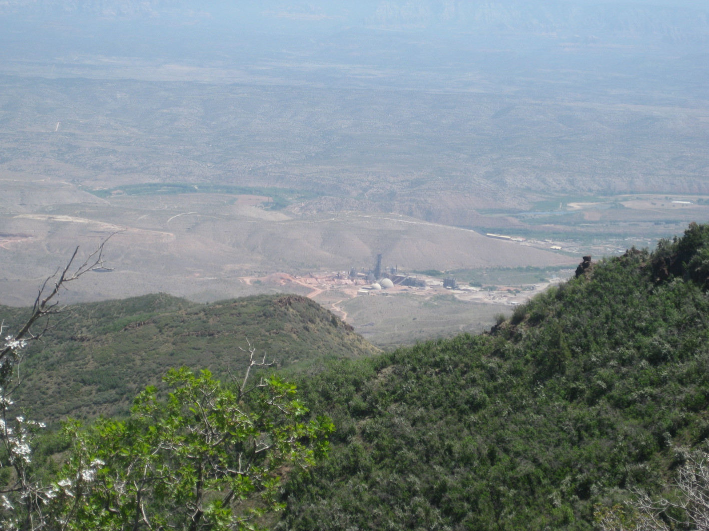 |
Cement plant at Clarkdale and Verde River from north Woodchute
|
From
the point where we first stopped for an overlook of Verde Valley, we
hiked on up the crest of the ridge for about 70 yards toward the top
of the mountain before stopping for lunch. After lunch I took a nice
long nap while the rest of the party hiked on up the ridge for an
undetermined distance before returning.
They
did awaken me before leaving; however, when I saw that they were
going the wrong way (up the trail instead of down), I promptly went
back to sleep to await their return. We were after all only about 60
feet below the rim of the mountain plateau, and that was close enough
for me. When they returned, we all proceeded back down the mountain
to the trailhead.
Along the way back down
the trail, George identified another two flowers for me.
 |
Lewis flax
|
 |
Claret cup cactus
|
 According to GPS
measurements, the total hike distance for me on this 16 May 2009 hike
was 6.6 miles round trip and the elevation gain was 2200 feet.
According to GPS
measurements, the total hike distance for me on this 16 May 2009 hike
was 6.6 miles round trip and the elevation gain was 2200 feet.
Previously, on 17 July
2008, George Everman and I hiked the entire length of Woodchute
Trail. We positioned one vehicle at the north end of the trail and
then drove to the south end to start our hike. The track shown in
red on the included map (below)
was made during that trip. The track for the 4 May 2013 hike, shown
only where it deviates from the official Woodchute Trail (right)
is in blue. The 16 May 2009 track is not shown at all as it did not
deviate. The map icons labeled “End 090516” and “End 130504”
show where the hikes on those dates ended. The distance between the
two icons is about 0.1 miles.

No comments:
Post a Comment