This
hike report is based on a 22 March 2014 Skyliner hike and is
supplemented with material from a 16 January 2014 scouting hike.
Hikers participating in the scouting hike included Lila Wright, Kwi
Johnson, Gary Jacobson and the author. The 22 March hikers are
identified in the below photograph, taken by Name Withheld.

Left
to right: Theresa Schnack, Don Kling, Akemi Tomioka, George Everman,
Daisy Williams, Connie Woolard, Kwi Johnson, Collene Maktenieks, Ruth
Frazier, Betty Wolters and Lila Wright – the ice cream rock is
visible
above Daisy's head
 We
had originally planned to hike to some ruins we had heard were
located on a ledge in Deadman Pass. However, our guide, a hiker who
had previously visited these ruins, was not available. Undaunted, we
decided to hike all the way through Deadman Pass and then continue up
Long Canyon to the Amphitheater Ruins instead. The scouting hike was
done because, although we had a location marked for the Amphitheater
Ruins, none of us had actually visited them. The hike starts at the
Boynton Canyon parking lot and, as made clear on the trailhead sign
(right), the Boynton Canyon and
Deadman Pass Trails coincide for a short distance, about 0.1 mile.
At that point Deadman Pass Trail turns to head northeast and Boynton
Canyon Trail turns northwest and continues on up the canyon.
We
had originally planned to hike to some ruins we had heard were
located on a ledge in Deadman Pass. However, our guide, a hiker who
had previously visited these ruins, was not available. Undaunted, we
decided to hike all the way through Deadman Pass and then continue up
Long Canyon to the Amphitheater Ruins instead. The scouting hike was
done because, although we had a location marked for the Amphitheater
Ruins, none of us had actually visited them. The hike starts at the
Boynton Canyon parking lot and, as made clear on the trailhead sign
(right), the Boynton Canyon and
Deadman Pass Trails coincide for a short distance, about 0.1 mile.
At that point Deadman Pass Trail turns to head northeast and Boynton
Canyon Trail turns northwest and continues on up the canyon.
Two
of the hikers on the 22 March hike had previously been to the ledge
house ruins in Deadman Pass. They showed Lila where to turn off, a
faint trail located and 0.8 miles from the trailhead at Boynton
Canyon parking lot, and pointed out the general area, shown in the
photograph below, where the ruins are located. We plan to scout the
area and then add a trip to those ruins as a future hike.

Showing
the general location of the Deadman Pass Indian Ruins – photo by
Lila
About
1.3 miles from the Boynton Canyon Trailhead, we reached the end of
Deadman Pass Trail

 We
turned northwest on Long Canyon Trail and almost immediately entered
the Red Rock Secret Mountain Wilderness. Around one mile from the
Deadman Pass/Long Canyon Junction, we came to Buttrock (right),
a very distinctive rock, embedded in the trail, marking the turnoff
to Ice Cream Rock and the Indian ruins hidden behind that formation.
From Long Canyon Trail, it is just 0.4 miles to the ruins.
We
turned northwest on Long Canyon Trail and almost immediately entered
the Red Rock Secret Mountain Wilderness. Around one mile from the
Deadman Pass/Long Canyon Junction, we came to Buttrock (right),
a very distinctive rock, embedded in the trail, marking the turnoff
to Ice Cream Rock and the Indian ruins hidden behind that formation.
From Long Canyon Trail, it is just 0.4 miles to the ruins.
The
trail, having passed through a forest of juniper, scrub oak and small
manzanitas, was now in a section dominated by larger trees, primarily
oaks with an occasional large manzanita. The

manzanita has always
fascinated me with its dark chocolate-colored bark and the seeming
ability to rise from the dead, as evidenced by new growth springing
from seemingly dead limbs and, as shown in the photograph (left),
healthy growth bypassing dead areas of their trunks.
There
were a few spring flowers blooming along the way, particularly
noteworthy were the two shown below, a claret cup cactus (left)
and a western wallflower (right).
 |
| Claret cup cactus - by Lila |
 |
| Western wallflower – by Lil |
The
turnoff to the Amphitheater Ruins is located about another 0.5 miles
up the canyon from Buttrock. To access these ruins one crosses the
wash and follows a faint trail that climbs up a short, steep cliff
and then continues across a large flat area to the ruins, shown in
the following photograph, visible in a cliff wall ahead. There is a
distinct trail that leads to the ruins; unfortunately, there are also
number of other distinct distinct trails in the area. The best
course is to just take a fix on the ruins and take whatever trail
that leads toward them.

The
Amphitheater Ruins are visible in the overhang just to right of,
and
slightly below, center
 The
slope just below the ruins is a steep, precarious climb, but made
easier by toe holds cut into the rock, as shown in the photograph
(right).
The
slope just below the ruins is a steep, precarious climb, but made
easier by toe holds cut into the rock, as shown in the photograph
(right).
At
the top of the steep slope, one is greeted by the remains of
individual rooms tucked into an overhang in the cliff face. As can
be seen in the below photograph, extensive smoke discoloration is
visible on the overhang above the ruins. The photograph, taken by
the author in January 2014, shows the best preserved dwelling at
these ruins.
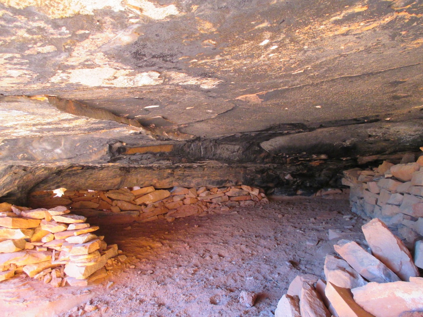
Ruin
of a dwelling at the Amphitheater
 |
| Rock showing ripple effects |
 |
| Sharpening grooves |
The
two stones photographed below show, respectively, the ripple effects
of being underwater in the ancient past (left)
and indentations made by sharpening arrows (right)

View
enjoyed by the cliff dwellers – photograph by Lila Wright
There are additional
ruins located about 0.1 mile to the southeast of the Amphitheater in
a small canyon. These are situated in two caves on either side of a
deep pool of water. To access them, one leaves the main trail as
though to access the Amphitheater Ruins, but then turns right and
travels up the small canyon instead of climbing the cliff after
crossing the wash. They are located about 0.4 miles from Long Canyon
Trail.
The hike was 6.8 miles
round trip, the elevation at the trailhead was 4392 feet and the
elevation gain was 839 feet.
The
GPS track for the hike is shown in red on the included map (below). Parts of Long
Canyon Trail are shown in blue and the tracks to the other ruins
discussed in this report are shown in green.

No comments:
Post a Comment