On
13 March 2010, eleven Skyliners (Jim
Manning, Fran Lind, Marvin Alt, Bob Wakefield, Janet Wakefield, Daisy
Williams, Donna Goodman, Lila Wright, Ellis Price and two others)
set out to hike on Sugarloaf and Black Mountain. W took Hwy 89A
north from Cottonwood and turned off on Bill Gray Road (FR 761) at
the Catholic Church. We followed Bill Gray road for about 9.3 miles
and then continued straight ahead on Black Mountain Road (FR 9525).
Bill Gray Road turns to the right at this intersection. We followed
Black Mountain Road for about 1 mile before parking to start our
hike.
NOTE 1: Alternate
Route -- Instead of turning off Bill Gray Road (FR 761) directly
onto Black Mountain Road (FR 9525) where we did, one could continue
on Bill Gray Road for about another two-thirds of a mile and turn
left onto FR 761A. FR 761A connects with Black Mountain Road, which
itself becomes FR 761A at this point, where Black Mountain Road
crosses under the power line, about three- tenths of a mile beyond
where we parked.
NOTE 2: Turnoff
to Indian Cave – At the point where Black Mountain Road crosses
under the power line (at 34°52'56.20"N; 111°59'55.97"W),
FR 9524 leads off to the northeast, generally following the power
line. The Indian cave described later in this report is located in a
red bluff on the right a bit under a quarter mile along this road.
We hiked along Black
Mountain Road, heading generally northeast along the slope of Black
Mountain toward Sugarloaf Mountain. Along the way (about half a mile
after crossing under the power line) we noted a jeep trail, an old
quarry road (FR 9526) that branches off and switchbacks up to the top
of Black Mountain. We continued on past the jeep trail turnoff on
our way to Sugarloaf Mountain. We found that we were climbing pretty
rapidly and paused a few times to rest and take in the views.
Black Mountain Road
runs along the slope of Black Mountain until it reaches Sugarloaf
Mountain, which is joined to Black Mountain by a connecting saddle.
The road then continues around Sugarloaf Mountain and leads to
several quarries located on the northeast slope of Black Mountain.
Some of the quarries are still active and the road is pretty well
maintained. Any truck type vehicle can easily navigate it.
We would leave Black
Mountain Road at the saddle between Sugarloaf and Black Mountain
because the climb to the top of Sugarloaf is not too steep from
there. Accordingly, when we reached the saddle we turned off and
made our way up the slope.
We found no
discernible trail leading between the road and the top of the saddle.
However, from there on to the peak, we did find a faint trail,
marked along the way with cairns. As we ascended, we had a good view
back along the way we had come; the road along the slope of Black
Mountain was clearly visible and, in the distance, we could see the
snow-covered heights of Mingus Mountain above the shoulder of Black
Mountain.
 |
Mingus visible in the distance above the slope of Black Mountain – road visible at bottom of picture
|
And because I do
like Mingus, here is a zoomed in view.
 |
Magnified view of Mingus over the shoulder of Black Mountain
|
The climb up
Sugarloaf from the saddle is not very difficult, although there are a
couple of spots where one must climb over rock ledges.
We ate lunch while
admiring the views from the top of the mountain. We searched for and
found a memorial someone had patiently carved into a stone at the top
of the mountain. We then spent the rest of our time enjoying the
views all around us. Looking to the west, we could see Black
Mountain Road zigzagging its way up to the quarries located on the
northeast slope of the mountain. One vehicle made its way along the
road around Sugarloaf and on up to the quarries while we watched. We
saw the same vehicle again later as we were making our way back down
to the road and the vehicle was leaving the area. Looking to the
northwest we could see across Sycamore Pass into Sycamore Canyon
Wilderness beyond. We identified the Trailhead for the Dogie Trail,
a trail we plan to hike on April 10. To the northeast we could see
the red mound that identifies Robbers Roost and beyond that Secret
Mountain Wilderness. Moving to the southeast, we were looking down
on Sugarloaf Tank #1 just below us and beyond that the Mago Retreat.
The tank is located in the bottom of and not too far from the upper
head of a canyon. The canyon bottom drops steeply again just below
the tank. The canyon descends from west to east and we could see
that a road climbs up the canyon on the south side, crosses at the
tank and then descends back down the canyon on the north side. I
determined later that this road turns around the shoulder of
Sugarloaf and continues north to Sugarloaf Tank #2, which is located
north of Sugarloaf Mountain. It can be accessed from Black Mountain
Road by turning north on FR 9524 where Black Mountain Road crosses
under the power line near the start of our hike.
 |
Memorial carved in a stone on top of Sugarloaf Mountain
|
To the west we could
see Black Mountain Road winding up the slope to the quarries.
 |
Black Mountain Road zigzagging up the northeast slope of Black Mountain to the quarries
|
Looking northwest,
we had a view across Sycamore Pass into Sycamore Canyon Wilderness.
 |
Looking across Sycamore Pass and into Sycamore Wilderness from Sugarloaf Peak
|
To the northeast we
could see across Robbers Roost into Secret Mountain Wilderness.
 |
Robbers Roost (red mound in center) and Secret Mountain Wilderness beyond
|
To the southeast we
could see Sugarloaf Tank #1 far below and the Mago Retreat beyond
that.
 |
Sugarloaf Tank #1 (lower right) and Mago Retreat (above and left of center)
|
Making our way back
down to Black Mountain Road, we came out about 50 yards from where we
had left the road on the way up.
On rejoining the
road, we decided to make a side trip to the cliffs overlooking
Sugarloaf Tank #1. Accordingly, we continued along the road for
about two-tenth of a mile as though we were going to circle around
Sugarloaf Mountain before turning off to the cliff above the tank.
After arriving at the top of the cliff, we decided that a better view
was to be had at another location and moved along the cliff edge
toward the head of the canyon in which the tank is located. Below is
a view of the tank from our second viewpoint. The tank is visible to
the left; you can see the Mago Retreat near the upper right.
 |
Sugarloaf Tank #1 (left); Mago Retreat (upper right)
|
While we were
wandering around atop the cliff, we observed a small manzanita in
full bloom (a bit early?), a small juniper growing on the very edge
of the cliff, a stubborn prickly pear cactus that just refuses to
give up and some strange mushrooms. George, who is traveling and was
unable to be with us on this hike, is our mushroom person and I will
ask him to identify them for us when he returns from his trip.
 |
A Manzanita in bloom A little juniper on the cliff’s edge
|
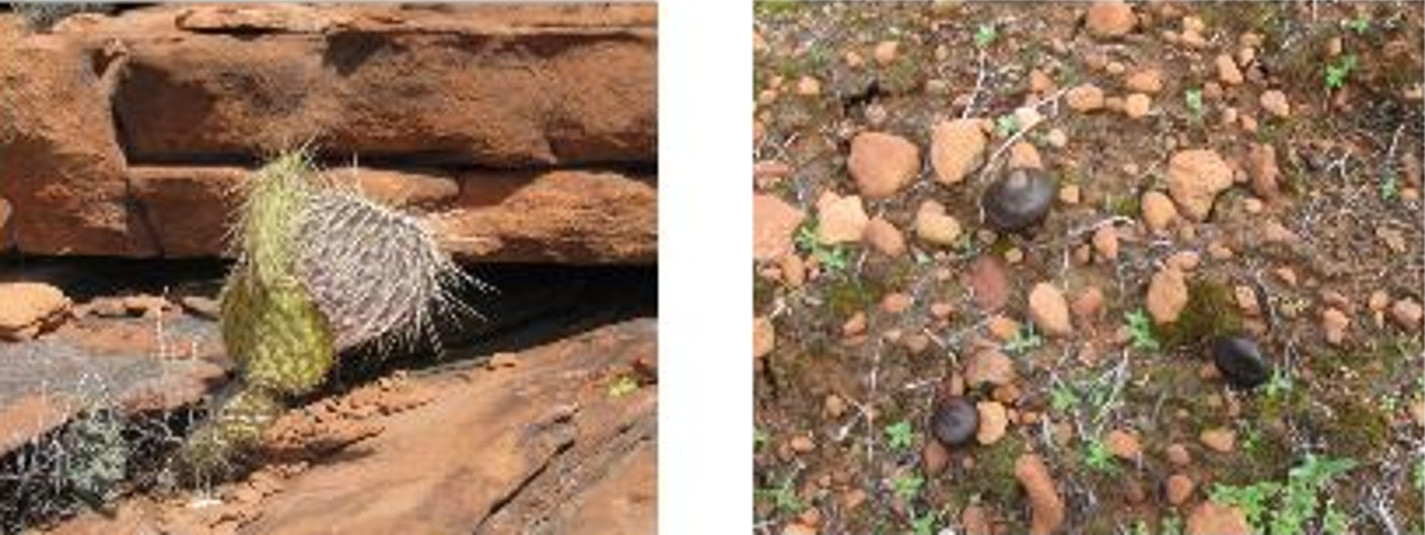 |
A very stubborn prickly pear cactus Small black mushrooms
|
Jim Manning had
indicated that he knew of some Indian ruins located near our route
back and we left to explore those. To do this, we returned to Black
Mountain Road, hiked back past where we had turned off to climb
Sugarloaf Mountain, continued on past the jeep trail (FR 9526) that
switchbacks up to the top of Black Mountain and turned off when we
could see the red bluff that the Indian Ruins are located in. We
noted later that the most direct route should one wish to go directly
to the ruins would be to turn off Black Mountain Road onto FR 9524
where Black Mountain Road crosses under the power line and follows
the power line to the northeast. The ruins are in a red bluff to the
right a bit under ¼ mile from Black Mountain Road. However, because
we were on our way back and approaching from the other direction, we
shortened the trip a bit by cutting off before we reached FR 9524 and
taking a diagonal route to the ruins. We traveled through
pastureland that was pretty easy walking.
We found the ruins
(located
at 34°53'4.43"N; 111°59'42.51"W) to
be basically a cave-like opening in the bluff under a rock overhang.
The overhang was deep enough to provide shelter in just about any
weather. The site is easily accessed, lying only about a tenth of a
mile off FR 9524. Because it is so easily accessed, the site has
undoubtedly been much visited over the years. Despite this, we did
find a few pottery shards, which we photographed and left behind. We
also noted some very interesting erosion formations on the back wall
of the overhang.
The space sheltered
by the overhang is about 10 feet deep and at least 30 feet long,
providing ample space to shelter a small group.
Indian Ruins. See
the opening at the bottom of the red bluff, visible over the top of a
bush (right of center)
 |
| Indian Ruins. See the opening at the bottom of the red bluff, visible over the top of a bush (right of center) |
 |
| Pottery
shards Erosion formations on the Back wall of the overhang |
 |
Assembling hikers framed in the opening with Mingus in the background
|
This hike was about
6.75 miles round trip (My GPS said 6.74 while the file I downloaded
to my computer said 6.5). This includes the side trips to the cliffs
above Sugarloaf Tank #1 and the Indian Ruins. The elevation change
was just over 900 feet.
The included map
(below) shows our GPS track for
this hike.

No comments:
Post a Comment