Friday, June 30, 2017

TREKABOUT WALKING CLUB-July 2017


Walks are graded on a 1-4 scale (with 4 being the most difficult)
Meet Every Tuesday - hikes starting at 7:00am at trail head (subject to change)
HIKING SHOES RECOMMENDED/CARRY WATER/DOGS MUST BE ON LEASH
To join TrekAbout Walking Club, please email at jen.mabery@yavapai.us
Or call: 928-634-6877/928-301-6143
Get up and get moving! And it’s free

Tuesday July 4th!
Happy 4th of July!! Get out and do something!


Tuesday July 11th
Doe Mesa Trail” – This is about a 2.5 mile trail with a steep elevation gain. There are some very beautiful view rewards at the top!

Level 2.5(if your not used to the climb a 3)

Directions: From Cottonwood head to Sedona and turn left on Dry Creek Rd, Follow to the first T and turn left, follow to the second T and turn left. Go past the Fay canyon trail head and the next big parking lot on the left is Doe Mountain trail head.

Tuesday July 18th
Mingus Mountain” (Don’t know the real name) – I would say about 3-4 miles out and back. Go through some pines along the way to a very nice outlook view. Nothing too strenuous.

Level 2.5

Directions: From Cottonwood, Head up to Jerome, continue 4.2 miles beyond Jerome. You will then see a large pull out on the right that also has a big brown Prescott National Forest sign.


Tuesday July 25th
Cathedral Rock Summit” – This will only be about a 1.5 mile hike, but it has a very steap scramble to the top/center of Cathedral Rock. It is so awesome in the heart of the rock. Time to sit and stare or explore.

Level 2.5

Directions: It’s in the village of oak-creek, so coming from Cottonwood; head to Sedona via 89A then turn right onto HWY 179. Follow to Back O Beyond rd. and round-about to the right. Follow that until you get to the trail head.


Tuesday, June 20, 2017

The Big Block Walk - 170615


Several times during the past few weeks I have felt the urge to do a longer walk than the 2.5-mile jaunt around my immediate neighborhood. At first, in response to that urge, I ventured up Rio Mesa Trail to Quail Run and continued as far as I felt comfortable in going. Eventually, I substituted Desert Jewel and a small section of Contention for part of Quail Run because it is a more interesting route. Finally, rather than returning from my walk the same way I had gone, I continued to the south end of Quail Run, turned east on Quail Springs Ranch Road and followed it down the mountain to Old Hwy 279 (Camino Real) which I then followed north to Arrowhead Lane and then home. This route, 4.7 miles in length, is shown on the following map. I call it The Big Block Walk.

The Big Block Walk
As noted, I had walked this route several times before today, but always going counterclockwise. Today, having determined that the climb to Quail Run would be more gradual that way, I hiked it in the clockwise direction.

Leaving home, I followed Arroya Vista and Arrowhead to Old Hwy 279 (Camino Real) turned south and continued to Quail Springs Ranch Road. This was still a gravel road in the early 2000s when I first walked this way. I think the county must have paved it primarily as a dust abatement measure and I suppose it serves that purpose adequately. However, the road bed was not prepared properly before the asphalt was applied and much patching has been required since.

Much-patched Quail Springs Ranch Road
Just a short distance along Quail Springs Ranch Road I noted one of those ubiquitous road adoption signs which are used to announce organizations and individuals who have committed to keeping particular sections of road clean. This section appears to have been adopted by a public-minded tin lizard. He seems to have been doing a pretty decent job of it; there was very little debris scattered along the right of way.

The tin lizard who adopted a highway
The next noteworthy site along the walk is Quail Canyon, a gated community of 1.6- to 3-acre parcels. It boasts of “Electric Gas Water Paved, Curbed Roads.” Altogether, it appears to be an exclusive community of those who consider themselves a cut above the unwashed masses. To me that all added up to a group of people seeking to limit access to their community. However, when I paused for a closer look I noted something very odd about the physical arrangement of the main entrance to the complex. There are two separate gates, one for entry and another for exit. The entrance was unguarded and the entry gate stood wide open. It appears that anyone can enter but it is not evident that one can leave without a gate pass as the exit gate seems to be securely fastened.

Free to enter. But what about leaving?
Emblazoned on a sign near the entrance was a likeness of the bird for which the complex is named, Gamble's Quail (right). This bird is sometimes confused with the California Quail. As a matter of fact, I was told they were California Quails when we first moved to Arizona and only recently learned the difference. The example shown here is a male, distinguished by the copper-colored top feathers.

There are a number of side roads leading off Quail Springs Ranch Road, mostly just leading to one or a few homesites and ending. Some of these appear to be private drives while others seem to be maintained by the county. So far as I can determine a white sign with brown lettering indicates a privately-maintained road while a green sign with white lettering denotes a road that is maintained by the county.

However, some markings defy this neat logic. For instance Anica Lane is marked with a green and white sign on one side but sports an older sign on the other side proclaiming it to be a private drive and prohibiting trespassing or turning around. It could just be a left over sign from before the county adopted the road. Or it might be a small group of property owners struggling for exclusivity on the cheap. On the other hand, perhaps green on white really does not indicate that the road is maintained at taxpayer expense.

A mistake or struggling for exclusivity on the taxpayer's dime?
Continuing up the gently-sloping mountain I soon reached Quail Run and turned north. This is a road that I have walked often over the past fifteen years as a part of the Big Block Walk, at first as a break from report writing while I was still working.

A short distance from Quail Springs Ranch Road I found an unexpected patch of dodder (left). This is a parasitic plant that I was familiar with from growing up in East Tennessee. I tended to associate it with that sort of relatively high-humidity climate and was surprised to find it growing in such a dry spot and hosted by such sparse vegetation.

A little farther along, while crossing the wash below Pasture Well, I noted a sign (right) that warned passersby to “Beware of Dog,” the sort of sign that is more commonly posted on private property such as a fenced yard where a dog is kept. This looked more like an attempt to prevent people from walking up the wash on National Forest land. There are a couple of private homes located up that way and I am sure they have dogs. However, it they are left free to roam on the National Forest, an area open to the public, after the owner has already admitted by posting the sign that they are dangerous, I wonder about the legal consequences if someone were attacked. On the other hand, this is Arizona and reason doesn't always apply.

A short distance farther along Quail Run I crossed Christina Draw Wash, the same wash that runs by my house about a mile down the slope from here. This wash drains a large section of the eastern slope of Mingus Mountain south of Allen Spring and north of Black Canyon. Although normally dry this wash can become a raging torrent during monsoon season, overflowing its banks and damaging road crossings as it struggles to drain the water falling on the mountain slope above.

The short, not very difficult, climb out of Christina Draw Wash going north on Quail Run is the steepest part of The Big Block Walk when traversed in the clockwise direction. When traveling in the counterclockwise direction on the other hand the climb up the mountain on Desert Jewel (or on Rio Mesa, whichever is chosen) is much more difficult because elevation is gained more quickly.

On this day, refreshed by a cooling breeze which quickly evaporated the perspiration generated by my exertion on a 100+ degree day, I moved right along, soon turning east on Rio Mesa Trail. I made another right at Contention and then turned down the mountain on Desert Jewel. I usually choose this particular route because I just find it more interesting than Rio Mesa. For example, one house displays an eclectic gathering of artifacts grouped at a mailbox.

Eclectic collection of artifacts grouped at a mailbox
The purpose for the mailbox is obvious and I think the stove likely expresses the householder's opinion of junk mail. I have no idea what the cart with the half-barrel containers mounted on it represents. Nor do I know what the Indian (?) God or Goddess might represent.


I continued down the mountain to reconnect with Rio Mesa Trail at the end of Desert Jewel. Rio Mesa then took me to Camino Real which I followed to Arrowhead Lane, on to Arroya Vista and then home. As already noted the distance was 4.7 miles; the highest elevation was 3711 feet and the total ascent was 480 feet.

Friday, June 16, 2017

The Neighborhood Walk – Update 170614


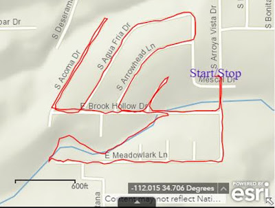
The Neighborhood Walk is a 2.5-mile walk that grew from a 1.5 mile walk that I started doing around my neighborhood in Verde Village Seven when I commenced chemotherapy earlier this year. I then extended the walk to 2.3 miles by including another street and finally to 2.5 miles. The 2.5-mile walk is shown below.

Neighborhood Walk – 2.5 miles
A short section of the 2.5-mile walk is down the wash at the bottom of Christina Draw and, although the wash is open and affords easy passage, there is a short, steep descent to enter it at the end of Meadowlark Drive. Today, I decided that I would build at least a rudimentary trail for the descent. The dirt was loose and easy to dig with a shovel-shaped rock I found nearby and there were plenty of other rocks to use for shoring up the lower side of a narrow scooped-out trail. After about 15 minutes of effort I would up with what I consider a much-improved descent into the wash.

Improved descent into Christina Draw Wash
The official monsoon season starts tomorrow and I am hoping the rains arrive soon afterward. That should help to consolidate the work I did today and show me where I need to make improvements.

For the most part this walk has already been described and photographed in a previous report:

In this report I will just point out a few new sights and some seasonal seasonal changes I have noted during the time I have been traveling this was. For instance, today I met a friendly rabbit (right) who hesitated long enough for a photograph before he decided I was probably a predator out looking for lunch and scampered off into the brush.

Since the last report on this walk I had stopped at my friend Angel's house to have my photograph taken with him and to collect a photograph of Angel in uniform during the Korean War.

Ellis Price and Angel Vargas – 26 May 2017
Angel Vargas during the Korean War
Having already spent several minutes constructing my trail into the wash, I did not stop today at Angles house (or museum as I call it) to chat and admire his collection of antiques from his old homeplace, the Alvarez Ranch at Sycamore Canyon. These can be seen, along with other items collected during his career in the National Guard and while working as a munitions expert in the already cited report:
As I continued on down the wash, I was alert for other wildlife; in addition to the pervasive quails and frequent lizards, I have seen at least one jackrabbit, albeit a little further down the wash between Arroya Vista Drive and Old Hwy 279 while on another walk. I was much too slow with my camera to photograph it; however, I did find a good photograph1 (left) on Wikimedia Commons.

Leaving the wash and heading west on Brook Hollow Drive, I paused to photograph a century plant (right) I had been patiently watching for several days as it slowly came into full blossom, gradually turning yellow .from the bottom up. Finally, on this 14th day of June, it was in full bloom, framed by matching Mexican bird of paradise shrubs and shown against the background of Mingus Mountain.

Continuing west on Brook Hollow Drive, I turned north onto Acoma Drive, a short street that runs downhill and ends just 0.2 miles ahead at a wash . I walk down and back on it because because it adds 0.4 miles to my walk and presents a nice, invigoration climb on the way back.

Just a short distance along Acoma Drive, a very short street called Acoma Circle leads to the west. This is actually more a driveway than a real street as it just leads to a single, vacant, hillside lot, still for sale. I checked it out several times waiting for some large sunflowers to bloom, finally with success.

Sunflowers blooming on a vacant lot at the end of Acoma Circle
After walking to the end of Acoma and returning to Brook Hollow, I turned north on Agua Fria Drive. Along the way, tucked under a sugar sumac shrub and protected from the hot afternoon sun, I found a vibrant, sacred datura (left) in full bloom.

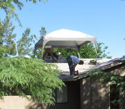
At least three of the houses along the way have been re-roofed since I began doing this walk. In one instance the roofer had come up with a rather ingenious method of shielding himself from the sun. He had erected the sort of portable canopy one often sees at campsites. The roofer said it cost him about $150 at WalMart.

Roofer protected from the sun by a portable canopy
Still on Agua Fria Drive, there is a vacant, overgrown hillside lot for sale that supports all sorts of indigenous plants. The most striking among these for now is a gorgeous cactus (right).

Agua Fria Drive ends at Del Mar Drive and the homeowner on the corner of those two streets has a motley collection of three very noisy dogs. One is a medium-sized mutt and the other two are small, extremely shrill yappers. They all seem to think it is their duty to alert the entire neighborhood every time someone walks past in the street. I finally resorted to carrying a dog whistle and stopping dead in the street and blasting their ears with all my might until they stopped barking. The larger dog soon got the idea and shut up. The smaller ones took a while longer. But I can now walk past with a minimum of barking; a couple of blasts from my whistle usually does the job.

After reaching Del Mar Drive I turn back on S Arrowhead Lane, return to Brook Hollow and follow it to Arroya Vista Drive and then home. But because that does not quite make a 2.5-mile walk, I take a short detour up and back on Elk Circle. Elk Circle is a pleasant street with attractive homes. However, glaring in its contrast with the otherwise pristine surroundings, is an old abandoned car. I noted it when I first started walking this way, primarily because a piece of side molding had come loose at one end on the driver's side door and was hanging down to the street. Sometime later the attachment at the front end of the molding strip had also given way and I kicked it under the car where it is at least less visible. Meanwhile, the derelict vehicle continues its steady deterioration. Today I noted that the left front tire is flat. It will soon be time for cinder blocks or a tow truck.

Its about time for cinder blocks or, hopefully, a tow truck.
Back on Brook Hollow Drive, I cross Christina Draw Wash once to reach Arroya Vista Drive and then again in the remaining short distance home. There I am greeted by a gorgeous bank of yellow lantana. We planted the lantana in an iris bed several years ago and found that it takes over and begins blooming each year just about the time the irises are done and continues until frost. We remove the dead foliage each fall and wait for the cycle to begin again with the return of the irises in the spring. We eventually planted another bed of lantana, red this time, for a bit of contrast.

Yellow lantana in the foreground; red lantana and Texas sage in the background
This is not a very long or very strenuous walk; however, in the heat of summer, I am always ready for a quick nap when I get home.


1Jessie Eastland (https://commons.wikimedia.org/wiki/File:Big_Ears_Sitting.jpg), https://creativecommons.org/licenses/by-sa/4.0/legalcode

Tuesday, June 13, 2017

Ellis Health Update - 170613

Background

I am undergoing treatment for Stage 4 Mesothelioma Lung Cancer. The problem started with chest pains on 2 January 2017 after I returned from my workout at the gym. A trip to the emergency room resulted in a CT (computed tomography) scan that revealed a mass in my right lung. A later biopsy indicated it was mesothelioma; a sample was sent to the Mayo Clinic for a second opinion; Mayo concurred in that diagnosis and I was sent for a PET (positron emission tomography) scan at the Verde Valley Medical Center clinic in Sedona, the nearest facility with a PET machine. Following the PET scan I was referred to the Arizona Oncology Center Sedona facility in the same building. I saw Dr Anthony at the oncology center who discussed treatment options and recommended chemotherapy consisting of the following two drugs: Pemetrexed and Carboplatin, treatment which I am now undergoing.

Previous posts touch on this subject are shown at:
and
and

Current Status

On 6 June we went to Sedona and saw Dr Lindquist (Dr Anthony has accepted a research position at an institute in California) for a scheduled chemotherapy visit; however my platelet count was too low and she rescheduled it for next Tuesday, 13 June (my 85th birthday; she noted that and offered another date but I declined because I like the Tuesday schedule). She also changed me from a three-week schedule to a 4-week schedule and scheduled a PET Scan for 22 June. Dr Lindquist prescribed temazepam to help me sleep while taking dexamethasone (steroid) tablets for the three-day period surrounding each chemo treatment. It seems to work as I slept for almost 8 hours the 0n 12 June, the night before today's chemotherapy session. I usually have a couple of down days following chemo. Perhaps some of that has been caused by sleeplessness.

Additionally, she referred me “to Dr David Sugarbaker at Baylor College of Medicine for an opinion on surgery for mesothelioma.” I fly to Houston on 25 June and expect to return home on 1 July. At my advanced age, I am an unlikely candidate for surgery, but if there is a chance that surgery could be performed, possibly resulting in remission, I am willing to consider it. After all, the chemo treatment I am now undergoing is only intended to keep the cancer under control, possibly prolonging my life for another couple of years and I suspect that my quality of life would deteriorate significantly over that time.

Meanwhile I am still holding up quite well. I did my usual 2.5-mile walk yesterday and would have aimed for the 4.7 mile “big block” walk today had not the chemo treatment interfered. I will see how I feel tomorrow and perhaps go for a walk after Julia leaves for the airport. She has been a very welcome and most helpful visitor for the past ten days.

Both she and Diana will meet us in Houston for the evaluation with Dr Sugarbaker's team. Hopefully, Julia's husband, Rick, will also be able to come. I have not seen him for some time.
My next update will likely be sometime in early July