On
30 April 2016 we hiked on Tomkins Trail #513 in the Black Hills south
of Copper Canyon. We had hiked the lower part of the trail, starting
at Copper Canyon, on 12 February 2008 and again on 27 November 2010.
Our aim now was to hike the rest of the trail, starting at Box T
Spring and ending at the terminus of the 12 February 2008 hike. To
do this we would hike on Forest Road 9602G from FR 732 to the Trail
513 Trailhead at Box T Spring, follow Trail 513 for 1.5 miles to
Durfee Tank and continue for another mile on Trail 513 to the end of
our 12 February 2008 hike, about 0.3 miles above Tomkins Tank. There
we would turn back, retrace our steps to Durfee Tank and then follow
FR 9603E back to FR 732.
We
left Cottonwood at 0700, drove on SR 260 to Camp Verde, turned south
on I-17 and drove to the SR 169 Exit. There we turned east onto
Forest Road 732 and drove 2 miles to the junction with FR 9603E where
we left one of our four vehicles. We then continued on for another
0.9 miles to park the remaining three vehicles at the junction with
FR 9602G to start our hike. But first we posed for a group
photograph on the bank of Cienega Creek
 |
| Left to right: Lila Wright, James McGinnis, Valerie Hillyer, Ellen McGinnis, Terry Johnson, Daisy Williams, Karl Sink, Anita Jackson, Betty Wolters, Jim Gibson, Collene Maktenieks, Gilliam Ashworth, Jim Manning, Loren Pritzel and John Ashworth – author not shown |
The
weather report had predicted a 30% chance of rain and possible wind
gusts of up to 33 mph for the area and we were all carrying or
wearing raingear as we started our hike, under an overcast sky, with
a brisk climb on FR 9602G.
 |
| Starting the hike with a brisk climb |

We had hiked this way just two weeks ago while completing a section of Box T Trail #511 and had found a number of interesting flowers along the way. This time the most colorful thing I saw a single, forlorn groundsel that I didn't bother to photograph. I did, however, more closely examine a metal, skid-mounted, tank (right) that we had seen on that previous hike. It was tucked under a tree on the bank of the wash that runs downstream from Box T Spring and had a plastic pipe coming from that direction tucked into an opening at the top. A discharge pipe was mounted near the bottom on the downstream end of the tank. Although the tank was completely dry at the time, we assumed that it must have been installed to regulate the flow of water to some downstream location. The letters, “U S Army,” stenciled on one end, indicated that it was an Army surplus tank.
Just
a short distance above the tank we came to Box T Spring. Some of
today's hikers had not been to the spring before, so they lingered
for awhile examining it and the surrounding area. The spring is a
major junction as trails and forest road junctions go. The map
insert (below)
shows the road/trail system at the spring. The red track, leading in
from the west (FR 9602G) and leaving heading north (Trail 513), shows
our track today. The magenta track, leading in from the south and
leaving to the east before turning back south, is Trail 511.
 |
| The trail/road junction at Box T Spring |
Trail
513, on which we were hiking today, runs between Box T Spring and FR
136 in Copper Canyon, a distance of 4.5 miles; Trail 511 runs
between FR 68D at Joe Best Spring and Salt Mine Road, a distance of
11 miles, looping north to pass Box T Spring on the way.
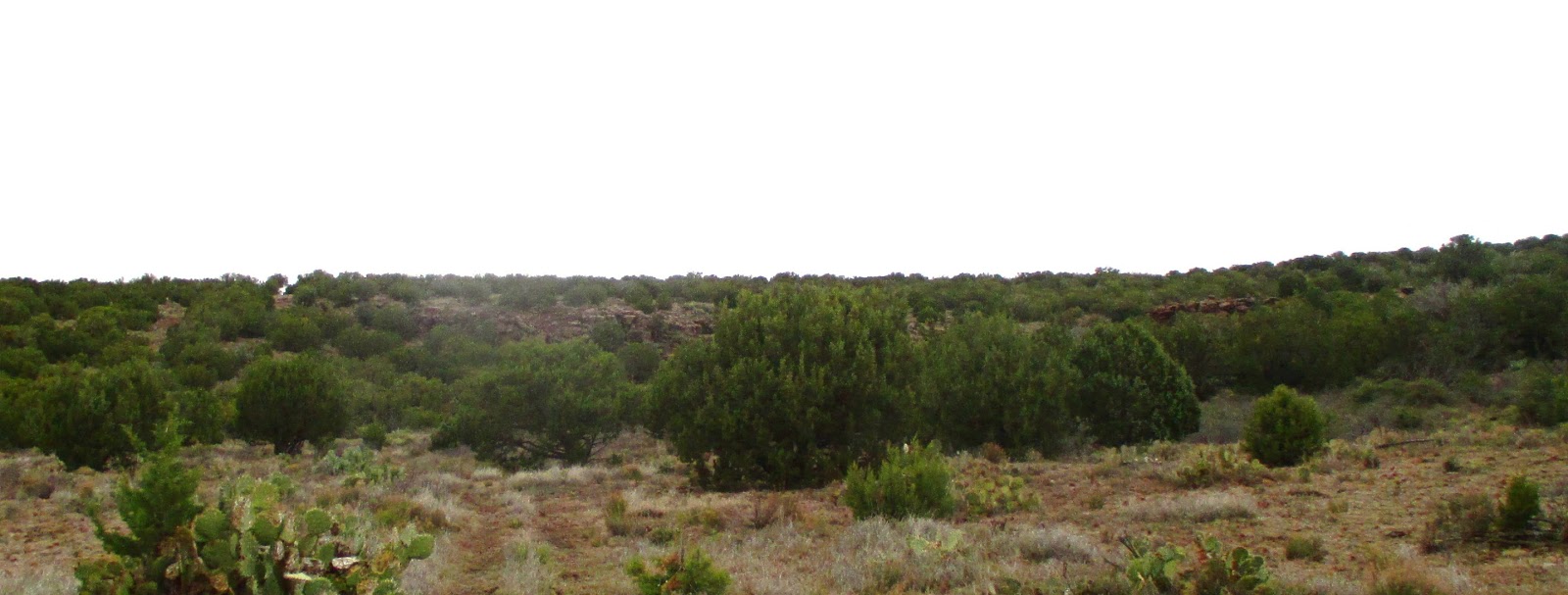
While
the other hikers were looking around, I took the opportunity to
photograph the view looking back the way we had come. Although we
still had cloud cover and light mist, I could see across Prescott
Valley to the distant mountains beyond. The scene (below)
is actually composed a of several photographs stitched together.
 |
| Looking back the way we came from Box T Spring |
We
had recently been at the spring several times without seeing anything
more than a friendly jackrabbit. However, several cows (below
left)
were milling about today. I also noted an old overgrown branding
chute (below
right)
that I had missed before.
 |
| Cattle at Box T Spring Old disused branding chute |
From the end of FR
9602G, we turned north and followed Trail 511 about 175 yards to the
beginning of Trail 513. We stopped on this short stretch of trail
for a snack break and then continued on our way. The trail at first
dips into a shallow wash and then climbs up a low hill. As we
started up the hill I saw a very pretty groundsel (below
left) , its bright yellow flower
rising above a bunch of dark red and green leaves and a contrasting
patch of silvery grass growing alongside. A few yards farther along
the trail was a lonely aster (below
right) stubbornly growing from the
baked and cracked earth.
 |
| Groundsel bouquet Aster |
As we ascended the gentle slope, the trail (actually an old road) became quite rocky and when we came to the top we saw another low hill with a steep cliff running along its side. Luckily, nature had provided a break with a gentle slope up which our trail ran.
 |
| Second low-lying hill between Box T Spring and Durfee Tank |

The trail, still quite
rocky, made its way up the slope in the break between the two
sections of rock cliffs and then turned downhill for a short distance
to arrive at the junction with FR 9603E. We were at the eastern rim
of Durfee Tank which lies at the head of a side canyon that empties
into Copper Canyon at the site of an old stage station on General
Crook Trail, now FR 136 at this point. A year-round spring Is
located in the lower part of the canyon near the old station. I call
it Copper Canyon Spring; but all the maps I have seen just refer to
it as “Copper Canyon Water.” We paused for a few minutes and
then turned east on Trail 513. We hiked for another mile, stopping
along the way to admire the strikingly beautiful red flowers of a
hedgehog cactus (above right), to reach
the terminus of our February 2008 hike the crest of a ridge about 0.3
miles above Tomkins Tank. We stopped there to eat lunch before
turning back.

I made myself a cozy
nest in the gravel just under a cliffrose shrub (left)
and settled in for what I intended to be a lengthy post-lunch nap.
From my perch, I could look north-northwest along the Black Hills
Range to Pinto Mesa directly across Copper Canyon. To the right of
the mesa, I could see a slice of the Verde Valley; to the west was
Prescott Valley. I contentedly settled in for my nap; alas, I had
barely closed my eyes when the first raindrops fell. It never rained
hard, just enough to ensure that we all donned our raingear. Trying
to stay dry while napping in the rain is a tedious business, so I
raised no objection to a quick departure and we headed back.
 The trail back to
Durfee Tank was generally downhill and from the tank we just followed
FR 9603E back to FR 732. Meanwhile the rain stopped and the sun came
out briefly; however we could see more clouds moving in and we
hurried along at a good clip. I did pause to photograph a spring
beauty (right) that I spotted
alongside FR 9603E.
The trail back to
Durfee Tank was generally downhill and from the tank we just followed
FR 9603E back to FR 732. Meanwhile the rain stopped and the sun came
out briefly; however we could see more clouds moving in and we
hurried along at a good clip. I did pause to photograph a spring
beauty (right) that I spotted
alongside FR 9603E.
We passed through two
gates on the way from Durfee Tank. The first gate had a quite
deceptive latching mechanism. It was one of those mechanisms where a
lever moves a bolt carried on the gate into a slot in the post,
normally a quite secure arrangement. However, in this case, the post
had moved and the bolt barely caught in the slot; the slightest gust
of wind would spring it open. As a fix, the rancher had fastened a
chain with an easily-operated bolt snap to the post. The chain
could be wrapped around the frame of the gate to secure it.
Unfortunately, once the chain was loosened it hung unobtrusively
against the post and the unwary passerby was likely to just use the
more obvious but insecure latch. We were pretty well strung out by
now and I had to wait until the last hiker had passed through to make
sure the gate was secured, so I was the last hiker to finish the
hike.
We were all back at the
junction of FR 732 and FR 9603E by about 1300. However, having
decided that it would not be advisable to drive the non-high
clearance passenger car we had left there over a pretty rough section
of road to where we had started our hike, the three drivers continued
afoot to pick up their cars. The distance was only about a mile; but
the incident did remind us that we should be more careful in future
about the vehicles we choose to drive.
Our hike is shown by
the red track on the the included map (below).
The yellow track shows our drive along Forest Road 732 to the
junction of FR 732 and FR 9603E and on to the junction of FR 732 and
FR 9602G. The short sections of green track (upper right) are
portions of Trail513 hiked on 080212 and the magenta-colored sections
of track (bottom center and bottom right) are portions of Trail 511.
The
hike was 7.7 miles in length (8.7 miles for our three drivers Lila,
Jim and Collene), the highest elevation was 5223 feet, the total
ascent was 1053 feet and the total descent was 958 feet.

No comments:
Post a Comment