We
hiked the North Mingus Tadpole Loop on 1 November 2014. The hike is
called “tadpole loop” because it forms the shape of a tadpole
when drawn on a map. We usually start the hike at the hairpin turn
in Forest Road 493 between Copper Chief and Iron King Mines. From
there we follow the course of an old road, now blocked to vehicular
traffic, that leads from the bend in FR 493 to the lower Trail 106
Trailhead on Allen Spring Road. We then follow Trail 106 up the
mountain slope (passing Trail 105A, a connector trail that ties
Trails 106 and 105 together) all the way to the top of Mingus,
emerging at the overlook. From the overlook, we hike north on
Forest Road 104 to the Mingus Mountain Glider Port where we connect
with Trail 105 which takes us back down the mountain to the
intersection with Trail 105A, the connector trail. We then follow
Trail 105A back to Trail 106 and retrace our path to where we parked.
An
iron gate is installed at the bend where the old road once left FR
493 to make its way to the lower trailhead on Trail 106. The gate is
normally locked. But today we discovered that the lock was missing.
 |
Iron gate blocking road that once ran across Iron King Mine to Allen Spring Road
|
The
old roadbed, still eminently hikeable if not driveable, runs up the
mountain to pass just above the vertical scar in Mingus that is the
only visible sign of the old Iron King Mine site from the Verde
Valley below.
Until
a few years ago, around the time that Freeport-McMoran bought out
Phelps Dodge and acquired the site, I was able to drive my car, a
Mercury Sable at the time, along this old road and park at Allen
Spring Road above Iron King. Since then the owners have performed
extensive mitigation at the site, including filling in a large
sinkhole that was located just at the upper end of the vertical scar
that marks the mine. They also spent considerable time and effort
re-contouring, capping and reseeding the land surface above the mine
so that in time it should become almost indistinguishable from the
surrounding terrain.
As
we followed the old roadbed on past the now reseeded site above Iron
King that was once a sinkhole, we turned sharply to the right to pass
above the site. The roadbed along here has been excavated, fitted
with a liner and refilled with rock to channel water running down
from above away from the mine and directly into a natural wash. I
was informed by Frank Lombardo, a highway engineer by profession,
that this is called a “French drain.” I have seen such drainage
arrangements all my life but never before had a name for them. I
photographed the drain from near its top.
 |
Old road converted into a drain to divert water away from the mine site
|
At
the upper end of the French drain, the old roadbed turns left again
and rises gently for about 140 yards to Allen Spring Road. We
stopped at the turn for a group photograph with a cloudy sky and a
slice of Verde Valley as backdrop.
 |
| Left to right: Chris Jensen, the author, Jim Manning, Betty Wolters, David Beach, Frank Lombardo and Loren Pritzel – photograph by Name Withheld |
 This
last section of old road below Allen Spring Road has been blocked by
a series of rock barriers such as the one shown here (right)
placed to prevent the passage of motorized vehicles.
This
last section of old road below Allen Spring Road has been blocked by
a series of rock barriers such as the one shown here (right)
placed to prevent the passage of motorized vehicles.
We
had seen a sunny start to the day, but as can be seen in the previous
two photographs, clouds were now gathering and it was becoming a bit
chilly. Although the clouds were threatening it never actually
rained more than a bare sprinkle, but it did become very windy for
part of the hike.
Crossing
Allen Spring Road we took Trail 106 up the mountain slope, at first
following closely parallel to the road, but then pulling gradually
apart. A short distance up the trail we came to a mountain biker's
shortcut that runs almost directly down the mountain slope, passing
north of Iron King Mine, and connecting with Forest Road 493 below
the mine. I once followed that trail down the slope but, after that,
had absolutely no desire to hike it in the uphill direction.

 About
120 yards beyond the mountain biker's shortcut we had a clear view of
the spot where Indian Cave is located. It shows up as a red blob
(left) on a far hillside and is
devilishly hard to locate when one tries getting to it. George
Everman and I after spotting the opening from another viewpoint made
two unsuccessful attempts before finally actually getting to the
cave. The point on trail 106 from which we could view the cave is
shown in the photograph (right)
with green lettering (lower right quadrant) and the location of the
cave, also in green, is shown in the upper left quadrant.
About
120 yards beyond the mountain biker's shortcut we had a clear view of
the spot where Indian Cave is located. It shows up as a red blob
(left) on a far hillside and is
devilishly hard to locate when one tries getting to it. George
Everman and I after spotting the opening from another viewpoint made
two unsuccessful attempts before finally actually getting to the
cave. The point on trail 106 from which we could view the cave is
shown in the photograph (right)
with green lettering (lower right quadrant) and the location of the
cave, also in green, is shown in the upper left quadrant.
The
weather was now gradually closing in and the wind had picked up, but
we were mostly sheltered while on this side of the mountain. It was
cool enough, however, that I never removed my jacket and the clouds
were threatening enough that I kept my poncho ready at hand.

As
we drew farther away from Allen Spring Road we could look down the
slope to our right and see some of the fall foliage (left)
we had hoped for on this hike. These were orange-colored leaves on
small maples of the sort that grow at various sheltered locations on
the mountain.
Near
the junction with Trail 105A we met two bikers who asked questions
about the trail ahead. In particular they wanted to make sure that
they were on the correct path to to meet their pick-up party in
Cottonwood. We assured them that they were indeed on a trail that
would take them to Cottonwood but that they should take care to
connect with FR 493 at Iron King Mine.
Although
it was time for our normal mid-morning snack break when we reached
the Trail 105A junction we continued on for a short distance into a
grove of ponderosa pines for shelter from the wind. Ridges spread
out along here from the eastern face of Mingus much like so many
drooping fingers on a hand. Our sheltered spot in the ponderosas
was tucked into the upper reaches of a small valley between two of
these fingers. We were at an altitude of around 6700 feet and in the
upper edge of a band of ponderosa pines that extends along the face
of the mountain for around 3 miles, from Mescal Gulch to Twin
Springs.
Trail
106 emerged from the upper edge of the ponderosas after about 0.6
miles. The trail now angled up the face of Mingus, at first at a
gentle slope, but then through a series of steep switchbacks to the
overlook at the Mingus Recreation Area. The trail along here, as
had been the case all the way from the trailhead at Allen Spring
Road, showed signs of recent trimming. Along this area we also noted
that a number of large rocks had been moved and arranged to provide
support for the trail when it was originally constructed, and we
wondered what motivated those builders. Where were the travelers
coming from and where were they going?
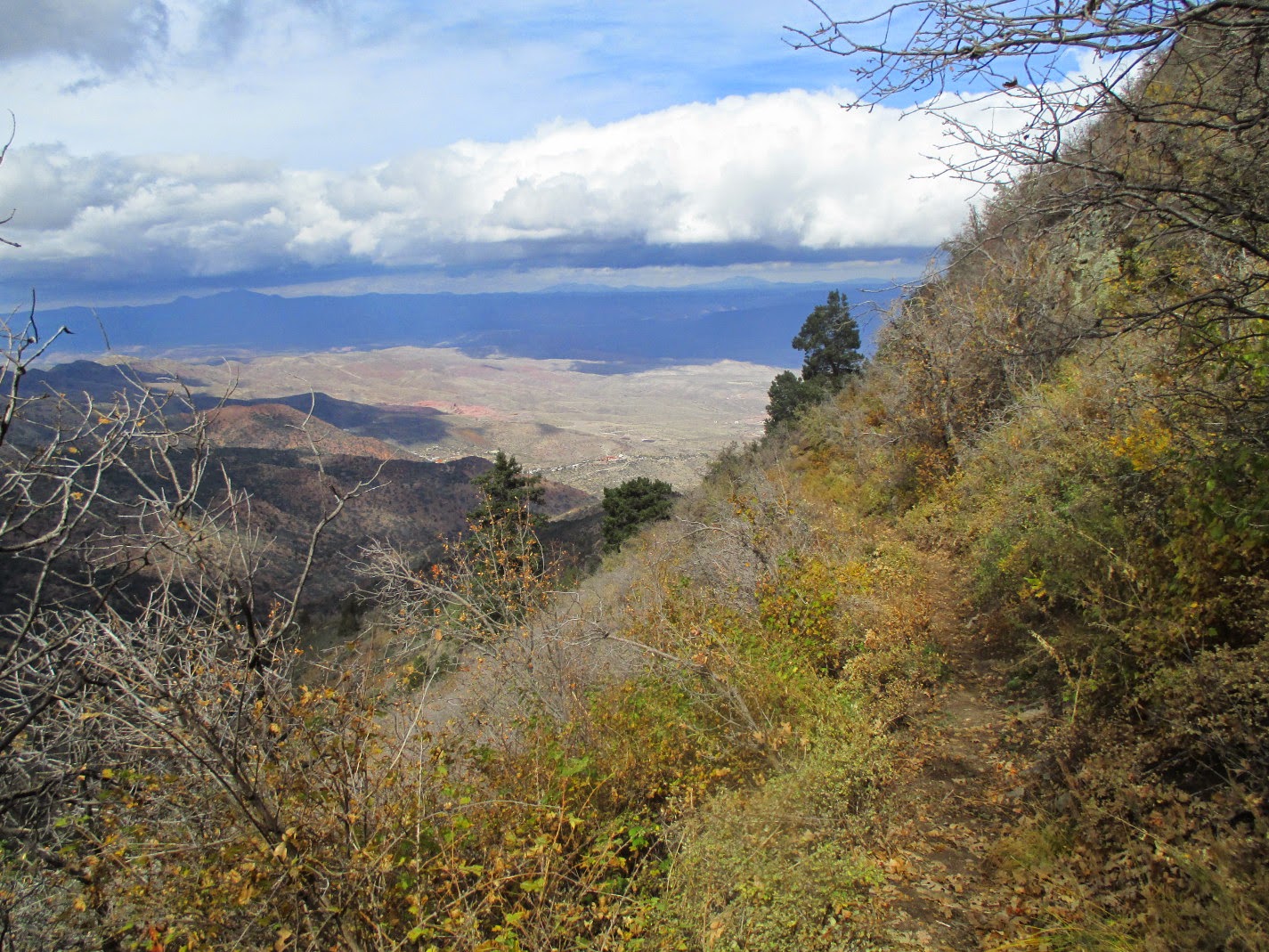
It
was a little windy along this southeastern slope, but it was not so
uncomfortable that we didn't pause often to admire the view along the
slope. We could see the colorful fall leaves of maples, ranging
through various colors from light yellow to dark red. The oaks,
meanwhile, made themselves known near the top of the mountain by
their trademark rusty red fall foliage while lower down the slope,
they were still green. The mountain ridges themselves faded away in
the distance, melding into the brooding clouds hovering above.
 |
Looking south along the eastern slope of Mingus from Trail 106
|
Along
this section we met two hikers with a dog doing the Mingus Mountain
Loop (Trails 106, 105A and 105) hike.
 When
we arrived at the Mingus Overlook the wind was blowing strongly and
we donned extra layers of clothing before settling down in a picnic
area for lunch. While The rest of the group gathered around a handy
table (right), I huddled in the lee
of a large pine tree to eat lunch. My extra layer of clothing
consisted of a hooded windbreaker, pulled on over the jacket I was
already wearing, and I was actually pretty comfortable.
When
we arrived at the Mingus Overlook the wind was blowing strongly and
we donned extra layers of clothing before settling down in a picnic
area for lunch. While The rest of the group gathered around a handy
table (right), I huddled in the lee
of a large pine tree to eat lunch. My extra layer of clothing
consisted of a hooded windbreaker, pulled on over the jacket I was
already wearing, and I was actually pretty comfortable.
Some
of the hikers who had chosen to eat at the picnic table were, on the
other hand, becoming quite chilly and seemed anxious to move on, so
I stirred myself to life and we headed north on Forest Road 104
toward the hang glider port.
A
short distance up the road we once again met the two hikers with a
dog, now almost done with their loop hike. Except for a couple of
adults and a small boy at the glider port they were the last people
we would see on this hike. And that is precisely why I like hiking
the trails on Mingus Mountain; one seldom meets more that one or two
other hikers.
 It
is only about 0.7 miles from the overlook to the Mingus Glider Port
and, even though we were now somewhat sheltered from the wind by the
surrounding forest, it was still cool enough that we moved along
briskly, soon arriving at the port. The red lettering in the sign
(left) gives the elevation as 7800
feet.
It
is only about 0.7 miles from the overlook to the Mingus Glider Port
and, even though we were now somewhat sheltered from the wind by the
surrounding forest, it was still cool enough that we moved along
briskly, soon arriving at the port. The red lettering in the sign
(left) gives the elevation as 7800
feet. We
saw a metal plate embedded (right)
in concrete at the foot of the glider launch pad reminding pilots to
“Hook In.” Apparently the sign was installed as a result of a
2008 accident which resulted in the death of pilot Kunio Yoshimura.
The name “Skywalker,” inscribed in the concrete base at lower
right, most likely refers to a fellow pilot who uses the name Randy
Skywalker and who witnessed the accident.1
We
spent a few minutes at the site enjoying the panoramic view of Verde
Valley spread out at our feet. We were at the very lower boundary of
a dark, heavy cloud, but the valley below was crystal clear, even
sun-drenched in part.
 |
Panoramic view of Verde Valley from the Mingus Glider Port launching pad
|
Leaving
the glider port behind we continued north along the rim to start our
descent on Trail 105. Although we saw no signs to guide us, the
trail was nevertheless easy to follow, showing signs of relatively
heavy usage.
We
were pleased to find that the mountain sheltered us from the still
brisk wind as we followed the ziz-zag course of Trail 105 as it
switch-backed its way down the northwest facing slope of the
mountain. The trail was easy to follow and there were only a few
places where one had to be extra careful with footing. Across the
shoulder of the mountain, as we descended we had an excellent view of
Jerome and the mine-scarred, but nevertheless beautiful, hills
surrounding the town.
 |
View of Jerome across the shoulder of Mingus from Trail 105
|
We
were soon enough at the saddle below the top of Mingus where Trail
105 makes a sharp left turn and heads north toward Mescal Gulch and
Connector Trail 105A leads south along the face of the mountain to
connect with Trail 106 just 0.5 miles ahead. It is just 0.27 miles
at a heading of 69 degrees, as the crow flies, from this junction to
the Indian Cave mentioned earlier in this report.
But
we had no desire to bushwhack our way to the cave today, instead
taking the connector trail back to rejoin Trail 106. On arriving
back at the Trails 105A/106 junction, we had traversed the tail of
the tadpole and the loop proper. Now we had only to retrace our
steps along the tail to complete our hike.
We
were relieved to find that the wind had now died down a bit and that
the cloud cover was dissipating as we made our way back down the
mountain past the trailhead above Iron King Mine and on to our
parking spot at the hairpin turn.
According
to my GPS this hike was 8.3 miles in length, with a maximum elevation
of 8760 feet and an elevation difference of 2192 feet.
Our
track is shown in red on the included map (see
next page).

1Phoenix
New Times Blog:
http://blogs.phoenixnewtimes.com/valleyfever/2008/09/hang_glider_pilot_who_forgot_t.php
No comments:
Post a Comment