Monday, December 21, 2015

Hike to the Diving Board at Oak Creek Village

Because of the many connecting trails in the area, the Diving Board hike requires some attention to detail. George Everman and I first scouted the hike last October and determined the best sequence of trails to use for this scheduled 19 December 2015 hike.

The trail, as hiked, starts at Yavapai View parking area which is located on the west side of Hwy 179 northwest of Bell Rock. To reach the parking lot, from the Village of Oak Creek, we drove north on Hwy 179 to Sedona. At the first roundabout in Sedona, at Indian Cliffs Road, we made a 180 degree turn, and returned south on Hwy 179 for about 1.6 miles to the entrance to the parking area. This parking area is located on a counterclockwise circle with parking spaces positioned along the outside perimeter on the southeast side.

The below group photograph was taken at the parking area after the hike was completed.

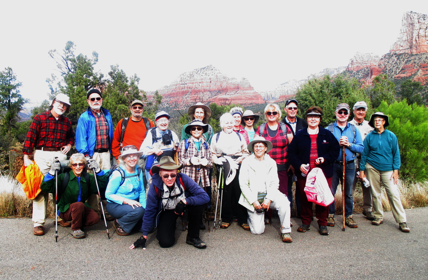
Left to right: (kneeling): Betty Wolters, Nita Nettleton, the author, Joanne Hennings; (standing): Gary Jacobson, Karl Sink, Chris Jensen, Daisy Williams, Dolly Yapp (front), Lila Wright, Collene Maktenieks, Ellen McGinnis, Connie Woolard, Gilliam Ashworth, Jim McGinnis, Iris Dobler, John Ashworth, Jim Manning and Beverly Sass – photograph with authors camera by a volunteer
Nineteen of a total of 22 hikers are identified in the above photograph. Jim Wagner, having a prior commitment to attend another event, had left the hike early while the rest of us were still eating lunch at the Diving Board.

From our cars, we walked clockwise around the parking circle, passing a toilet and a kiosk to reach the Yavapai Vista Trailhead (below left). We didn't actually hike on Yavapai Vista Trail, just walked to the sign and then turned sharply left onto a short connector trail (below right) that led us across a wash to Coconino Trail about 75 yards ahead.

We turned south on Coconino Trail (below left) and followed it for 0.3 miles until it ended at Slim Shady Trail (below right), passing Basalt Trailhead along the way.

We turned left on Slim Shady Trail and followed it for 0.3 miles to the junction with Made in the Shade Trail (below left). From this point, it is another 1.7 miles to the Diving Board. It is not clear just how much of this distance is actually traveled on Made in the Shade Trail. I have an old Arizona topographic map which indicates that our GPS track to the Diving Board departed from Made in the Shade Trail after 1.1 miles. The same map shows Made in the Shade Trail continuing southeast from there to connect with Canyon Ridge Circle in the Village of Oak Creek. On this old map, the last 0.6 miles of the trail we followed to the Diving Board is not shown at all. The trail (below right) became less distinct as we approached our goal. In a few places, as we crossed bare rock, it was not visible at all and we had to search for signs of a trail leaving the rock on the other side.

Eventually we turned sharply up the mountain, climbing about 350 feet in 0.3 miles. The slope up which we were hiking can best be viewed in the following photograph, taken from farther down the trail. In that photograph, the Diving Board is actually the flat top of the left shoulder jutting out from the butte shown in the photograph; the top is actually shaped roughly like a diving board.

About 1.5 miles from the Slim Shady/Made in the Shade Trail junction, the trail forks, one branch going straight ahead to a gap in the mountain (upper right in the below photograph) while the other turns sharply left and follows closely along the slope to the Diving Board.
We paused at the fork to decide whether we should continue on to the gap, only about 100 yards, to see what was on the other side, eventually deciding to do so on our way back.

The Diving Board as seen from the trail
The 0.2 miles section of trail on to the diving board ran first along the slope and then close along the cliff wall with little room to spare (below left). A small diving board-shaped formation appears at the corner of the cliff (below right), but it was not what we were looking for.

Rounding the corner we have our first close up view of the Diving Board we sought.

First view of the Diving Board
By walking out to the end of the formation we could look almost straight down on the Village of Oak Creek.

Looking down on the Village of Oak Creek from the Diving Board
We were rewarded by panoramic views from Bell Rock to House Mountain. The view below, looking across Hwy 179, shows Bell Rock and Courthouse Butte backed by Lee Mountain and Munds Mountain in the distance. In the lower right corner can be seen a small slice of the Village of Oak Creek.

Bell Rock, Courthouse Butte and a bit of the Village of Oak Creek
On the way back we paused at the gap for the following view. The outcropping at left is the backside of the butte above the Diving Board. Barely visible at the right is the cliff wall of the mountain range which contains Cathedral Rock. We did not determine for sure whether the trail continues beyond the gap to connect with Cathedral Trail at some point. We think that it does.

Jim Manning is shown viewing the Village of Oak Creek through the gap
The total hike according to my GPS was 4.8 miles including the short added hike to the gap. The highest elevation was 4616 feet and the total ascent was 656 Feet.

Our GPS track to the Diving Board is shown in red on the included map; the short blue line is the added track to the gap.


Monday, November 30, 2015

Robbers Roost and Casner Quarries


The Skyliners last hiked to Robbers Roost as a group in December of 2010. It had been even longer for our group leader, Lila Wright, who had missed that five-year-ago hike. She thought it was time to do it again and, even though I had hiked there with my Daughter, Diana, more recently, in October of 2012 to be specific, I agreed.

It was quite chilly, even with a brightly-shining sun, when we left Cottonwood shortly after 0800 on 28 November 2015. We traveled north on Hwy 89A, turned left onto Forest Road 525 at the Sedona Water Treatment facility (just past mile marker 364) and followed FR 525 for 2.8 miles before turning left onto FR 525C. On FR 525C (Sycamore Pass Road) we then drove seven miles toward the pass before parking at the junction with FR 9530.

Shortly after parking, we paused to take a group photograph.

Left to right: Lila Wright, Bill Thomas, Daisy Williams, David Beach, Peggie Thomas, Loren Pritzel, MaryAnn Reed-Cook, Robert Reed, the author (kneeling), Roger Fenske (rear), Joanne Hennings, Chris Jensen, Karl Sink, Gilliam Ashworth, Rita Faruki, James McGinnis, Ellen McGinnis, Jeanmarie Haney – photograph by Name withheld using the author's camera
From where we were parked it was only about 1.25 miles north on FR 9530 to the Robbers Roost Trailhead and when Diana and I had driven it in October 2012 it had been very rough. Diana, said the road was so rough that the pedometer she was wearing thought she was hiking and awarded her several hundred steps for the ride. Although still more suitable for high-clearance, preferably with 4-wheel drive, vehicles the road has improved greatly since that previous trip. There are no indications that any formal work has been done, the road is now fairly heavily traveled and traffic has worn down the worst of the rough spots.

Had we limited our hike to just visiting Robbers Roost, the one-way distance would have been only about 1.75 miles. We decided that was too short for a decent hike and added a trip to what I call Casner Quarries. This is the site of some old, abandoned, sandstone quarries on the slope of Casner Mountain just above the butte in which Robbers Roost Cave is located. To reach the quarries one just continues on FR 9530 for about 0.6 miles past the Robbers Roost Trailhead to the remains of an old shack at a fork in the road.

Remains of an old shack at a fork in the road
To this point the road could still be driven in a 4-wheel drive, high-clearance vehicle. However, neither road is driveable after the fork.

The left fork leads sharply on up the mountain for a short distance and then levels out as it follows along a rock seam that was the site of one or more of the abandoned sandstone quarries. The right fork, on the other hand, continues at a gentle slope along a lower seam. We had investigated both roads in 2010 and found the lower one to be both more interesting and a lot easier, so we chose the lower road.

Having climbed more than 500 feet in the 0.6 miles from the Robbers Roost Trailhead to the fork in the road we appreciated the now essentially level trail. In a few places along the way, however, catclaw mesquite and prickly pear cactus seemed to be in competition to see which would be first to snag the unwary hiker. But with a bit of care, it was possible to avoid most of the claws and needles.

About a hundred yards from the fork we came to the remains of a makeshift shelter that someone had formed with the use of left over slabs of sandstone and tin roofing scavenged from the old shack. The shelter had looked rather cozy in 2010 (below left) but was now almost unrecognizable (below right).

At the time of our 2010 visit the area showed signs of someone having recently camped at this spot, possibly for several days. This was evidenced by indications of recent use of the shelter, by a small, recently used fire pit with a metal mesh grill on top and a cooking pot still setting on the grill. John McInerney took a photograph of the fire pit and the pot (below left) during our 2010 visit. The fire pit still exists along with a small supply of wood (below right). However, the grill top and the cooking pot are long gone.

The views were such as to distract us from watching out for the bearclaw mesquite and prickly pear cactus. The photograph shown below, taking looking east, is an example.

The Mogollon Rim is seen on the horizon; closer in, Doe Mountain with its distinctive flat top is visible at left, followed by Cockscomb, Courthouse Butte and Scheurman Mountain
Quarrying here must have relatively straightforward. The sandstone formation is neatly stacked in layers of various thicknesses as shown below.

Layered sandstone formation at old quarry site on Casner Mountain

We came to the end of the road (below left) after about 0.2 miles from the fork. Looking across the wash where the road ended (below right), it at first appeared that the road would continue. However, the road seen there did not connect with the one we were following.

Turning back we stopped at a wide grassy shelf for a rest and a snack. From our perch we had great views looking out over Robbers Roost Butte directly below and on across the Verde Valley to the Black Hills and the far distant mountains farther south along the Verde River.

Robbers Roost formation in the center

As we continued back down the mountain following our snack break we had a great view of Black Mountain which forms the south shoulder of Sycamore Gap.

Black Mountain at right, Sugarloaf at the left shoulder of Black Mountain, Black Hills on the distant horizon

We had become quite strung out on the way down the mountain and on reaching the unmarked Robbers Roost Trailhead we waited until we were all together again. The trail to the cave is only about 0.5 miles and is well-traveled and easy to follow for the most part, but one can go astray near the top of the butte. From the parking area it drops down into a wash and then climbs the other side to a saddle between Robbers Roost Butte and Casner Mountain proper. Upon reaching the saddle the trail continues sharply up the steep slope of the butte. Just below the top, a less traveled side trail leads off to the left, turns a corner and comes out at a sheer cliff face about 100 yards short of the cave. While the way appears precarious, there is enough footing to permit safe navigation. A very narrow trail covers part of the distance; for the rest of the way the hiker just leans into the cliff face and takes advantage of the rough surface of the rock for footing. The below photograph shows the narrow trail followed by the bare section of cliff wall just before reaching the cave.

Trail along cliff wall to Robbers Roost Cave
During our 2012 hike, Diana photographed the cave as she approached along the path.

Robbers Roost Cave
Although Robbers Roost is the generally accepted name for this cave, I have also found that some call it Shaman Cave. This may explain the hippy-looking character Diana and I encountered here in 2012. That experience is described in my book, Hiking in Northern Arizona – 2012/2013.1

While we were still in the cave, a bare-chested young man with long black hair, arrived with a guitar and what appeared to be a prayer rug. Seemingly under the influence of something, he mumbled something about it being, contrary to what he had been told, around four miles from where he started his hike. We gathered that he had come across country from the Indian Ruins at Loy Butte which, as he put it, were “locked up by the United States of ...,” followed by some indistinguishable muttering. The muttering included the word “wasp,” but I did not feel that it was meant as “WASP” or in any pejorative manner at all. He declined to have his picture taken and, when he started to to unroll his prayer rug, we left him to his meditations, continued along the now even more steeply slanting cliff face until we found a suitable spot and climbed on up to the top of the butte.

The highest point on the butte is located at the southwest corner, and that is where we planned to eat lunch. However, when we arrived, another couple were busy taking pictures at that spot, so we sat down and waited for a few minutes until they left. They apparently dropped down to visit the cave afterward as the man later remarked to Diana that he had listened to the young man in the cave playing his guitar and that it was “magical and awesome.”

The name Robbers Roost does not seem to be associated with any specific incident or any particular group of outlaws. Local legend as told to me by a, now deceased, hike leader, has it that the cave was once used by bootleggers and bandits. Sedona Monthly, which chose Robbers Roost as their Hike of the Month for March 2015, said in their description that “ A film called Robbers Roost was photographed in Sedona in 1923, but no scenes were filmed at its namesake.”2

Leaving the cave behind, we continued on along the cliff face for a short distance and climbed up to the top of the butte through a convenient crevice. It was now time for lunch and we all settled down to eat, and in my case have a short nap. It was still pretty chilly and a steady breeze was blowing across the top of the butte. However, I managed to find a clump of grass which provided some cover and was relatively comfortable. I don't know how long I slept before I awoke to the sound of people stirring about getting ready to leave. We were back to our vehicles and ready to head home by 1330.

We had seen a relatively large number of hikers today and I wondered if the Sedona Monthly article had caused that. I think we may have seen two hikers in 2010 and Diana and I saw seven in 2012. Today, however, there were at least fifteen hikers in addition to our group of nineteen. Oh, well, at least the increased traffic has had a positive effect on the road to the trailhead.

The hike distance today was 5.3 miles according to my GPS track. The highest elevation was 5514 feet and the total ascent was 1255 feet.

Our GPS track is shown in red on the map included below.


1Hiking in Northern Arizona – 2012/2013, pgs 122-123

Wednesday, November 25, 2015

Devil's Bridge from Chuckwagon Trailhead


October 21, 2015 started out a bit on the chilly side, but the sun was shining brightly, giving us hope for a pleasant hike to Devil's Bridge. My last visit to the bridge had been in March of 2009. However, I think some of the group hiked there in March of 2012 while the rest of us climbed the west face of Capitol Butte, Thunder Mountain if you prefer.

We drove north from Cottonwood on Hwy 89A to Sedona and turned west on Dry Creek Road, proceeding for 2.0 miles before turning right onto Forest Road 152 (some maps label FR as 152 Vultee Arch Road; some call it Dry Creek Road). In any case, after turning onto it, we drove another 0.2 miles before turning left into a large, paved parking area with toilet facilities. That means, of course, that you must display a Red Rock Pass or a U. S. Forest Service Golden Age Pass. The turn in is hard to miss because it is located just where the pavement ends and a line of partially-embedded boulders bisects the road ahead. If your vehicle can't cross the boulders, use the parking area.

This road has deteriorated significantly during the fifteen years I have lived in the area. I am sure this is primarily due to lack of funding but the resulting rough road must also be a favorable development for the jeep tour companies located in Sedona. A lot of their customers are surely tourists who would drive themselves if the road were maintained. I myself do not hesitate to drive the road, even as far as the Vultee Arch Trailhead where it ends, about 3.5 miles ahead. But I only do it in a 4-wheel drive, high-clearance vehicle equipped with skid plates. Four-wheel drive and high-clearance vehicles are, in my opinion, necessities; the skid plates are added insurance.

The upside of the non-maintained forest road is that a lot of work has been put into improving and adding trails to provide access to the area. For instance, whereas a few years ago one could drive up the road and do a short, 1.8 mile, in-and-out hike to Devil's Bridge, we would today park at the newly-developed parking lot and hike on Chuckwagon Trail and a short connector trail to reach the Devil's Bridge Trailhead. In this instance, it made for a 6.3 mile round trip hike, just about right. On the other hand, to hike some of the longer trails located farther up the road, one really does need vehicle access.

We donned our gear and gathered for a group photograph.

Left to right: David Beach, Chris Jensen, Daisy Williams, Roger Fenske, Gary Jacobson, Iris Dobler, Lila Wright, Nita Nettleton, Dirk Knehr, Ellen McGinnis, Jim McGinnis, Robert Reed, MaryAnn Reed-Cook – author not shown

We looked back over our shoulders to Lizard Head (below left) outlined against the sky along the slope of Capitol Butte and then fixed our eyes on the trail ahead (below right).

Although I had a GPS track for the trail we would follow, it was completely unnecessary. The path was well-worn and clearly marked. We left the parking area at the well marked trailhead and found ourselves traveling along a lightly forested hillside, the vegetation consisting primarily of juniper, scrub oak and manzanita. This light growth was soon interrupted by a wide slick-rock area, mostly devoid of vegetation, that formed the low point of a wash running down the slope of Capitol Butte and emptying into Dry Creek. After crossing this bare spot, the trail led us up a slight slope and into another stretch of junipers, scrub oaks and manzanitas. Looking west from this section of the trail we had a great panoramic view of the nearby red rock formations and the Black Hills on the horizon. The black hills can be seen stretching from the left to just past the middle of the below photograph. The red mound in the center is Cockscomb, the flat mountain behind the dead tree is Doe Mountain and the mountain at right is Bear Mountain.

The Black Hills, Cockscomb, Doe Mountain and Bear Mountain
After crossing a gently-sloping ridge, the trail descended into the next wash and the junipers and small shrubs gave way to Arizona cypress trees. The first specimens we saw were a rather scrawny lot but, as we moved deeper into the wash, the trees became larger.

The trail runs generally parallel to and, at first, quite close to FR 152. But after about 0.8 miles it turns away from the forest road before swinging back and crossing it to connect with the Devil's Bridge Trailhead. One result is that the distance by trail is almost a mile greater than by road. Recognizing this, the trail builders provided a connector trail (below left) here so that hikers can conveniently connect with the road if they wish. We chose to continue on the trail and soon came to a unique, laddered stretch of the trail (below right) that had been carved by nature in the bottom of a wash.

As we were crossing another juniper-covered ridge between sections of the trail that were overhung with Arizona cypress trees, we came to a second great viewpoint, from here we had a panoramic view into the Secret Mountain Wilderness.

Secret Mountain Wilderness–Doe Mountain (left) to Little Round Mountain (right)
We descended from the ridge and, deep in the Arizona cypress forest and, just 2.2 miles from the trailhead, came to the Devil's Bridge connector trail. The connector begins at the sign pictured here (below left) and ends at Forest Road 152, just across the road from the Devil's Bridge Trailhead (below right).

The distance from FR 152 to Devils Bridge is only 0.9 miles. The first part of that is along an old wagon road which is quiet steep in places (below left). Then it leaves the old road and becomes very steep (below right).

Don't be discouraged by the steep section of trail shown above. It is short and, despite the fact that they don't show up very well in the picture, there are steps to make the climbing easier.
In the below photograph, seven of our hikers are shown standing on the bridge. The trees shown in the background are on the other side of the canyon. The scraggly little bush in the foreground is a manzanita.

Left to right: Jim McGinnis, Lila Wright, the author, Chris Jensen, MaryAnn Reed-Cook, Robert Reed and Dirk Knehr
There were a lot of hikers at the bridge, but they were quite orderly, going onto the bridge one or two at a time, occasionally in larger groups, to have their pictures taken by compatriots waiting on the slope above. I chose a spot in the sun and photographed some of our group as they ventured onto the arch of the bridge.

We lingered for some time on the sunny rocks overlooking the bridge to watch the hikers. Some just looked at the bridge from the slope, some ventured tentatively out onto the arch as though they might be the person under whom it collapsed and some strode confidently onto the arch and turned walked on their hands or stood on their head to show their lack of fear.

We had delayed our midmorning snack until we arrived at the bridge because Lila had told us the mountain behind us would shade the area starting around 1100. As predicted, the sun retreated behind the mountain and we stirred ourselves for the return hike. On our way back, we moved smartly along until we found a sunny spot for lunch on the other side of FR 152. Unfortunately, I had perspired enough by then that my clothes were damp and a chill wind was blowing. I was just too uncomfortable for my normal noon nap, barely closing my eyes before being awakened by a cool gust of wind. I was ready to move on and my trailmates readily agreed.

We arrived back at the parking lot early enough that we decided to add a short scouting hike to the itinerary for the day. We planned to hike to Windmill Mountain next January and still had not determined just what route we would take. We had noted, while looking at an out-of-date map that an old road once ran toward the mountain, leaving the highway somewhere between the Sedona Wastewater Treatment Facility and the Dry Creek Bridge on Hwy 89A. We hoped to use that road for part of our hike. We just needed to locate it and hike on it far enough to find a good point from which to bushwhack our way to the top of the mountain. We determined that the access to the old road is now by way of the northernmost entrance to the wastewater treatment facility. One just turns off Hwy 89A as though entering the facility and then immediately turns right on a dirt frontage road. We parked there and explored on foot, finding that the old road, still marked as a forest road, will indeed lead us over half way to the top of Windmill Mountain.

Today's hike to Devil's Bridge and back turned out to be 6.3 miles. However, it can be shortened to 5.3 miles by taking the connector located 0.8 miles along Chuckwagon Trail from the parking area and continuing on FR 152. Additionally, one can drive on past the Forest Road 152 turnoff on Dry Creek Road to the stop sign, turn right on Long Canyon Road (FR 152B) and continue 0.6 miles to the Chuckwagon Trail sign on the right and shorten the hike to 4.3 mile. You will recognize the start of this hike by a small parking area alongside the road. Although it was marked as Chuckwagon Trail the last time I hiked it, it might be called Lost Way or Mescal Trail or Mescal Bike Trail. I have seen all three names on different maps.

Our GPS track for the 6.3 mile round trip hike we did today is shown in red on the included map (below). The highest elevation was 5009 feet and the total ascent was 1283 feet.

The alternative section of trail, starting at Long Canyon Road and resulting in a 4.3 mile hike, is shown by the blue track on the map.


Wednesday, November 18, 2015

Coyote Spring Trail


Coyote Spring Trail had been on my list of trails to hike since 30 May 2009 when I passed the trailhead on a hike to Martin Canyon. I finally got it placed on the Skyliner schedule for 14 November 2015. We took Hwy 89A south through Jerome to the Mingus Summit and turned right onto Forest Road 106, the paved road to Potato Patch Campground. About 0.30 miles from the highway, we angled left to continue on FR 106. Another 0.10 miles brought us to a the end of the pavement at a roughly circular graveled area with toilet facilities. We continued on through this area and left it going generally Northwest, still following FR 106 for about another 0.70 miles to arrive at Woodchute Trailhead where FR 106 ends.

Woodchute Trailhead at the end of FR 106 - the pedestrian gate (center) marks the beginning of Woodchute Trail

We, however, were not taking Woodchute Trail, only borrowing a bit of space in its parking lot. We donned our packs and left the parking area heading west on FR 106D. At first this road was well-maintained and had even been graveled recently. After about 0.2 miles, however, we passed through a fence with an open gate and found ourselves on an unmaintained dirt road. It was still passable for high-clearance, 4-wheel drive vehicles, but very questionable for other vehicles.
About 0.6 miles from the parking area we came to Hickey Tanks (plural because two tanks are located close together) and an unsigned fork in the road.

Unsigned fork in the road at Hickey Tanks – the right fork is FR 106

Assuming (correctly) that the left fork was primarily for access to the tanks, we continued along the right fork and shortly came to a viewpoint from which we could see into the Woodchute Wilderness.

Looking north across Martin Canyon, which runs behind the ridge marked by the peak at left, into the Woodchute Wilderness
While still at the viewpoint we posed for a group photograph, but we were in speckled sunlight and it came out so distorted as to make me dizzy just looking at it. I tried again later in the hike with even worse results, somehow getting no exposure at all.

Approximately 0.3 miles west of the viewpoint we came to another fork in the road. Here FR 106D turns to the left (south) and continues to Mingus Tank, passing the turnoff to Hickey Mountain on the way. We continued straight ahead on FR 106E and, after another 0.2 miles, arrived at the junction with FR 9710W which leads down the mountain to Turkey Tank and on to Martin Canyon. That is the route (although not identified as FR 9710W at the time) that we followed on 30 May 2009 for a loop hike from Woodchute Trailhead to Martin Canyon and then up the slope on Trail 104 to Woodchute Tank before returning to our starting point by way of Woodchute Trail. This time, rather than turning toward Turkey Tank, we continued straight ahead for another 0.1 mile to the Coyote Spring Trailhead. In May 2009 the trailhead was marked with the trail sign as well as with an Adopt-A-Trail sign indicating a trail sponsor (below left). Now the Adopt-A-Trail sign is gone and the trail sign stands alone (below right).

The trail, at first well-used and easy to follow, led down the spine of a ridge that separates Coyote Canyon, to the south, from Little Coyote Canyon, to the north. We had left the ponderosa pine forest behind and were now passing through an area populated mostly by junipers.

A section of Coyote Spring Trail near the upper end of the trail

Around 0.2 miles from the trailhead the trail made a sharp turn to the right and a less distinct path continued straight ahead to a viewpoint. We stopped at the there and I did get a photograph of the other five hikers as they enjoyed the view. Truthfully, I prefer such unposed shots. It is , however, admittedly difficult to identify individual hikers.

Left to right: Jim Manning, Lila Wright, Karl Sink, Daisy Williams and Joanne Hennings

We spent some time at the viewpoint enjoying the sweeping panoramic view which stretched from Prescott Valley at the left, past Granite Mountain on the western horizon to Chino Valley at the right.
Panoramic view from Coyote Spring Trail Viewpoint

Reluctantly leaving the viewpoint, we returned to the trail and continued down the crest of the ridge for another 0.6 miles before the trail started to angle down the southern slope into Coyote Canyon. By this time the trail had become much less distinct and we had to stop occasionally to get our bearings. Luckily previous hikers had placed a few ribbons along the way. These markers were especially helpful because the GPS track I had downloaded was wildly Inaccurate for all but the last mile and a half of the trail.

After about another 0.1 mile, most of the hikers wanted to stop for lunch and head back. It was really quite early for lunch, we were still about 0.75 miles from Coyote Springs and I really wanted to hike the whole trail. But some of the group were concerned about the time it would take to climb back up the steep trail we had descended and thought that, if we continued, we would be very late getting home.

Accompanied by Karl Sink, I continued for about another 200 yards to a point from which we could clearly see the canyon mouth, the spot at which the trail ends. Then, worried that we would be holding the rest of the group up while they waited for us to return before heading home, we turned back to join them for lunch. Later examination of my GPS track and measurements on a map disclosed that we were 0.7 miles from the end of the trail at Coyote Spring. To reach it we would also have descended another 540 feet in that distance.

On arriving where the rest of the hikers were eating, I quickly ate my meal and settled in for a nap before heading back. Sometime later I awoke to a disquieting silence. Looking around I saw no one and at first thought that the entire group had left me behind. Then, with some relief, I saw Karl's bright red backpack hanging on a nearby bush. A closer look disclosed Karl, himself, sound asleep under the bush. The other hikers, wide awake and still worried about the time it would take to complete the steep climb ahead, had made the quite sensible decision to let Karl and me finish our naps while they got a head start back up the trail. After all there were two of us and we both knew the way back. They may also have considered the well-known fact that I tend to be a somewhat grumpy hiker when awakened too soon from my noon nap.

The photographs below show the mouth of the canyon from where we turned back (below left) and a hiker struggling up the steepest part of the trail (below right).

During this hike we discussed other trails that some of us have hiked in the area, especially the Martin Canyon/Woodchute Trail Loop and the Hickey Mountain/Mingus Lake Loop hikes. To answer some of the questions raised about those hikes, I am including the below map insert that shows both of them along with today's hike. Martin Canyon/Woodchute Loop is shown as a blue track, Hickey Mountain/Mingus Lake Loop is shown as a cyan track. And Coyote Spring is shown in red (the hiked part) and green (the unhiked portion).

Showing Coyote Springs hike, Martin Canyon/Woodchute Loop hike and Hickey Mountain/Mingus Tank Loop hike.

The GPS track is shown on the included map (below) in red. The green line shows the short section of the trail that we did not hike.
Two sets of hike statistics are included below. The first is of the trail as we hiked it from the Woodchute Trailhead to where we stopped for lunch and turned back. The second set of statistics also includes the short part, 0.7 miles, part of the trail that we did not hike.

Our hike today was 5.3 miles round trip, the maximum elevation was 7273 feet and the total descent was 1083 feet. Had we completed the hike, the distance would have been 6.6 miles, the highest elevation would still have been 7273 and the total descent would have been 1673.


Thursday, November 12, 2015

Ash Creek Below Mingus Springs


Six Skyliners hiked along Ash Creek below Mingus Springs on 7 November 2015. We started this hike by parking at a gate marking the entrance to a 4-H Camping facility. We arrived there by driving south on Hwy 89A through Jerome to the top of Mingus, turning left onto Forest Road 104 and following it for 1.5 miles before turning right onto FR 413 which we followed for 2.3 miles before again turning right to follow FR 132 for 0.4 miles to arrive at Burnt Canyon Tank. Forest Road 105 angles right at the tank and we followed it for 1.5 miles to the locked gate at Mingus Springs 4-H Camp.

Locked gate at Mingus Springs 4-H Camp – March 2015 photograph

What is now the Harold and Mitzie James 4-H Camp & Outdoor Learning Center was established on 55 acres of a mining settlement that dates back to 1899.1 The original “prospectors patented 25 contiguous claims of over 500 acres along Ash Creek.”2

The James 4-H Camp website says it is a “100 bed camp has modern heated cabins with restrooms and shower facilities easily accessible. We offer a spacious dining hall, patio, fire pit and various activity areas for programming and a spacious lawn for play and learning. The health center is centrally located and all staff are CPR/First Aid certified and have passed federal and state background checks.”3

Eight other private holdings exist in the area and it is sometimes difficult to determine whether one is on private property or Prescott National Forest land. We did our best to stay on public land but were sometimes unsure of the boundaries. Basically, we just skirted the fenced 4-H Camp property and looked for no-trespassing signs for further guidance. Timber harvesting is underway in the surrounding area of the National Forest and the harvest boundaries marked by the Forest Service provided some guidance. However, this was not infallible as the loggers, apparently under an agreement with the camp, had also harvested timber in areas that seemed clearly to be on camp property.

We had originally scouted this hike last spring and had decided at that time to skirt the camp property by following the fenceline along the east side of the property. This involved hiking just a few yards from the gate back up the road we had driven in on and then leaving the road heading northeast at a bearing of about 71 degrees true. The goal is to hike along the fence running up the hill to the top where the fence corners and then runs southeast in order to bypass the private property. Just follow closely along the fence and you will find animal trails paralleling it all the way.

It seemed quite a steep climb from the road up to the fence corner and I later determined by examining my GPS track that we had climbed almost 450 feet in approximately 0.1 miles. It was indeed a good workout for the start of our hike, but it was mercifully short.
When we reached the corner of the fenceline, we stopped for a group photograph.

Left to right: Lila Wright, John Chartrand, Loren Pritzel, Daisy Williams and Karl Sink

The trail along here consists mostly of old cowpaths. In other words, no formal trail exists. On the other hand, the hiking is really not difficult if one just takes care to keep close to the fence. That was not difficult as cows tend to make paths close to and parallel with fences, looking for a way to the greener grass on the other side I suppose.

We found an occasional gate, always locked, in the fence and climbed into and out of several washes as we passed along a ridge above the campground. Although none of the washes were difficult or involved much climbing we were soon ready to stop for a brief rest and a snack. When we stopped we were only a little over a mile into the hike, but we had started off with a sharp climb and were now at a really good spot overlooking the small pond (lake?)the camp uses for boating and swimming. The camp calls it a 2-acre pond, the first use I have noted of the word pond for a body of water in Arizona. Where I grew up in East Tennessee almost every barn had an associated pond for watering stock, usually fed with water from the barn roof. Ponds, were also built in pastures that did not have access to a reliable year-round stream; these were normally filled with natural runoff from rains and snow. They were also sometimes so as to catch the runoff from a small stream. These were known as “spring-fed ponds” and I think were distinguished from lakes by the fact that a pond normally takes the entire stream flow whereas a lake, such as might be formed by a dam, would normally have an overflow of water. By this criteria the body of water at James 4-H Camp could be classified as a stream-fed pond. There was, however, a small amount of water flowing in Ash Creek below the pond, so might also technically be a lake. I really don't think a formal distinction exists.

Overlooking the two-acre pond at James 4-H Camp.

We crossed one fence (smooth bottom strand) running perpendicular to the fence we were following and, about 1.5 miles from where we parked, arrived at Ash Creek just below the camp. As shown below, we crossed the creek, a mere trickle flowing between large rocks.

Hikers approaching the Ash Creek crossing below James 4-H Camp

We were really unable to determine whether we were on forest land or private property at this point. Although still outside the fence that, insofar as we could tell, marked the camp's property line, we found that we were standing between two gates. One of these (below left) marked the entrance to the camp proper but was not locked; the other, leading away from the camp, was locked but was provided with a stile to permit easy access for hikers. The photograph of the stile (below right) was taken from outside the gate looking back toward the camp.

Looking south, away from the camp, we could see that the road we were on turned right and led to what appeared to be a private residence located on a bluff above Ash Creek. (Later investigation confirmed that the road ended there.)

Our trail led along the stream at the foot of the bluff. Along the way we found an old Airstream trailer of the sort used by NASA in 1969 to transport the Apollo 11 astronauts from Hawaii to Houston following the first moon landing. This part of the Apollo 11 recovery operation is outlined in my book At Sea & Ashore During Vietnam.4

All went as planned. The recovery aircraft were in the air and the President was already onboard when the Command Module splashed down. The Underwater Demolition Team fixed the module in place using a sea anchor and stabilized it with a flotation collar. They also provided BIG (Biological Isolation Garment) suits and a life raft for use while donning them. The astronauts then transferred to a second life raft from which they were hoisted one at a time to the hovering helicopter, which transported them to the Hornet about half a mile away. The recovery helicopter landed on Hornet’s flight deck, the flight crew disembarked, and the three astronauts along with a flight surgeon remained inside while it was moved onto elevator 2, lowered to the hanger bay and towed to the pre-positioned MQF (Mobile Quarantine Facility). Still in the BIG suits, the astronauts walked about 30 feet and entered the MQF (in which they would remain until transported back to Ellington Air Force Base aboard a C-141) and changed back into NASA flight suits.

We also saw an old, long unused, corral. A contact at the camp later told us that both Bottle Ranch and the Rafter T Ranch once had allotments and fences in the area. An online search returned no pertinent results for a Rafter T Ranch in Arizona. Bottle Ranch, on the other hand, still exists and is headquartered about seven miles downstream on Ash Creek. Judging from dried, but fairly recent, cow dung along the way, it appears that Bottle Ranch still uses the area for summer pasture.

The trail follows closely along Ash Creek, sometimes on one side, sometimes the other and occasionally on rocks in the streambed, for about 1.0 mile to the junction of Ash Creek with the creek below Strawberry Spring. This was our goal for the hike. However, on the March scouting hike, we had left the stream in favor of a fairly well-defined trail located on the left side about 0.6 miles below the camp and returned to it another 0.7 miles further downstream; we decided to continue to that point.

When we reached a place that we recognized from the scouting hike, someone asked how much farther it would be to the junction with Ash Canyon Trail, a trail some of us had hiked more than once. I later examined my GPS track and found that it would have been about an additional 0.7 miles. The map insert included below shows a GPS track of an April 2015 hike down Ash Canyon to Bottle Ranch (blue track) along with today's GPS track (red track)

The current hike in relation to Ash Canyon Trail

We paused for lunch and then headed back the way we had come. As we hiked along the stream it occurred to me that we had missed the best season for viewing flowers in this area. Our scouting hike in March had been a little too early and November was too late. However the flora on display was enjoyable in any season. We had started in a mature, although currently being logged, ponderosa forest, climbed to a hillside covered with junipers and other low-growing species as we passed above the camp and then descended back into the ponderosas again as we followed the creek. The immediate area along the course of the streambed has been kept clear, presumably by a combination of flooding and grazing. However the hillsides include a variety of species in addition to the ponderosa pines. Some of these, especially those sporting their fall colors, provided a pleasing contrast with the predominant pines. In particular, I was struck by a stand of colorful oaks (below left) and two lonesome birches (below right) thrusting gracefully skyward among the surrounding trees.

When we arrived back at the James 4-H Camp, we decided to try returning to our vehicles by hiking along the camp boundary on the west side. Although not very difficult and, for much of the way, easier going than hiking along the east boundary had been, this turned out not be as straightforward as we had thought. It was easy enough to stay outside the fence denoting the camp boundary. However, due to several cross fences, it was otherwise difficult to distinguish between forest land and private property. Additionally, the hiking distance was approximately 0.1 miles longer than on the east side.

Some of the group, with permission of one of the property owners, took a slightly shorter route by hiking through the camp for part of the way. They were told that it is normally possible to hike through the James 4-H camp with advance permission. We all arrived back at the parking area at essentially the same time.

The hike, as shown by the red track on the included map (below) was 6.2 miles in length, the highest elevation was 6777 feet and the total ascent was 1375 feet.


1http://extension.arizona.edu/4h/james-4-h-camp-mingus-springs
2Ibid
3Ibid