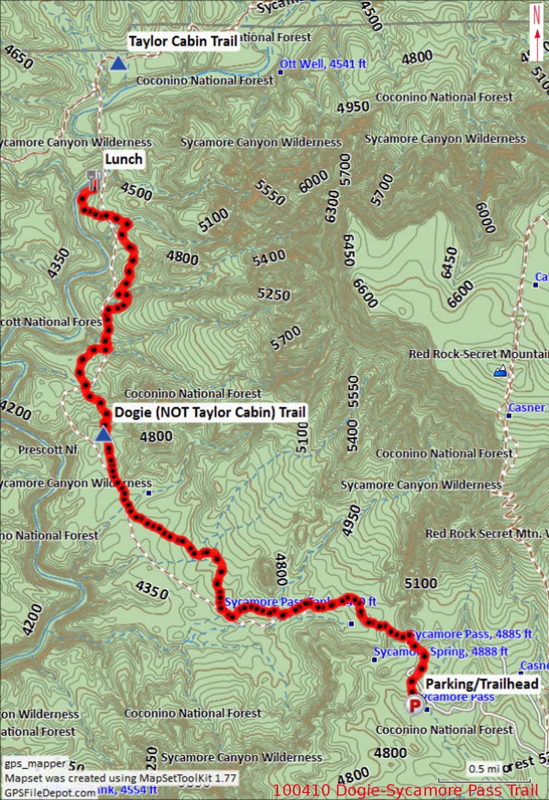
Parking at Sycamore
Pass
Location:
34°55'21.08"N; 111°59'41.80"W
Elevation: 4681
Thirteen Skyliners
(Donna
Goodman, Betty Wolters, Daisy Williams, Anita Jackson, Dolly Yapp,
Miriam Sterling, Marvin Alt, Gordon Bice, Fran Lind, Lila Walker,
Ellis Price and two others) hiked on Dogie Trail in the
Sycamore Canyon Wilderness on 10 April 2010. On 28 January 2017, Jim
Manning led a second group of hikers (Karl Sink, Glenn Sperry, Jon
Beach, Jim Manning, Chris Jensen, Jim Gibson, Dana Smith and Dave
Beach). From Cottonwood, both groups took State Highway 89A to FR
525 just past mile marker 364. Then followed FR 525 for about 2.8
miles before turning left on FR 525C (Sycamore Pass Road) and
continuing for about 9 miles to arrive at the Dogie Trailhead at
Sycamore Pass.
Our hike leader for
the 2010 hike, apparently still aggravated from our failure to remain
closely grouped on a previous hike, lectured us severely about
Skyliner Rules. Most importantly, we were told not to get ahead of
the leader and to remain together so that she would know where
everyone was at all times. She also said that we were supposed to be
a social group and that we were to remain together and enjoy
socializing as a group. Altogether, it reminded me of being chewed
out by Chief Petty Officer Weir, my Company Commander during recruit
training in 1951.
On the 2016 hike,
one member, had a problem with his legs part-way into the hike and
had to turn back; Dave Beach remained with him while the rest of the
group continued on to Sycamore Creek. I had noted in 2010 that a
couple of signs, with the trail name misspelled as “Doggie”
instead of “Dogie,” were posted at the parking area and along the
way to where the trail officially starts. No one mentioned the signs
on this hike and I don't know whether they have been corrected. In
any case hikers pass through a gate at the saddle about 200 yards
from the parking area and enter the Sycamore Canyon Wilderness
through a gate. Dogie Trail starts at this point.
After passing
through the gate in April 2010 , I paused to take a couple of
photographs looking ahead into the wilderness.
 |
Looking into Sycamore Creek Wilderness from the saddle
|
 |
Looking into Sycamore Creek wilderness from the saddle
|
On leaving the
saddle the trail, at first, leads fairly steeply downhill. The
following photograph shows the trail as it appeared in April 2010.
 |
Heading down into the wilderness from the saddle on Dogie Trail - 2010
|
For the current hike
it was covered with ice, as shown in the below photograph, provided
by Jim Manning.
 |
Treacherous, ice-covered trail in February 2017
|
Probably the most
distinctive rock formation along the trail is shown below. I thought
it looked a bit like a giant coffee mug.
 |
Rock formation resembling a giant coffee mug
|
We saw numerous
flowers along the way in 2010.
 |
Creamcups Dwarf mountain ragwort (?)
|
 |
Purple milkvetch Touristplant or Draba
|
 |
Plains blackfoot/Blackfoot Daisy Dock of some sort
|
Just under 1.75
miles from the parking lot we passed Sycamore Tank. The tank
contained very little water in 2010. But, as we noted on the way
back in on that hike, enough to attract a couple of migrating ducks.
Sadly, my attempt to photograph the ducks resulted in nothing useful.
However, Jim photographed the now-brimming tank, alas without ducks,
during the current hike.
 |
Sycamore Tank in January 2017
|
After traveling just
over 5.5 miles from the parking lot we reached Sycamore Creek. From
here the trail crosses the creek and continues upstream along the
opposite side to connect with the Taylor Cabin Trail about one-half
mile ahead. We stopped in 2010 and again in 2017 at the stream for
lunch before turning back. In 2010, I ate rapidly, had a quick hot
tea and settled in for a nap. I managed to find a nice spot several
yards from the group and the quiet murmuring of the creek soon lulled
me to sleep. I awakened about forty-five minutes later when the
other hikers were up and ready to head back up the trail. I lingered
a bit to take a photograph.
 |
Looking up Sycamore Creek from the Dogie Trail Crossing in 2010
|
The hikers report that Sycamore Creek was running full, bank to bank, at the time of the 2017 hike. Unfortunately, no one thought to take a photograph.
The total hiking
distance was 11.3 miles as shown by my GPS in 2010. This distance
was recorded from the parking lot to Sycamore Creek and back. So far
as I can determine, no GPS track was recorded for the current hike.
The GPS profile for the hike shows a maximum elevation of 4881 feet
and a minimum of 4194 feet. The elevation change on Dogie Trail
between the parking area and Sycamore Creek is only 687 feet;
however, the total in-and-out ascent, due to all the ridges and
washes crossed along the way, was recorded as 2251 feet. It is not
a difficult hike, but does require some stamina.
The map included as
part of this report (below) shows
the GPS track recorded in 2010 for this hike.
NOTE: On some maps,
Dogie Trail is incorrectly listed as part of Taylor Cabin Trail.
No comments:
Post a Comment