We
had hiked the Inner Basin Trail from Lockett Meadow to Waterline
Trail and then continued north on Waterline to Bearjaw Trailhead just
three weeks ago. At that time there was the barest hint of fall
shown on a few early-turning bushes along the trail between the Inner
Basin and Bearjaw. We thought that now, on 5 October 2013, the
aspens should be about at their peak, so we headed back to Lockett
Meadow for another hike through the aspen forest to Waterline Trail.
This time we would hike as far south on Waterline as we wished and
then return by way of an old road to the lower end of Lockett Meadow.
I had plotted the track we intended to take on a topographic map and
transferred it to my GPS, so we were confident that we knew the route
along the old road and, even if we didn't find it, we could return to
the meadow without any problem except perhaps some extra time.
There
were only five of us for this hike and we all piled into Kwi's car
for the trip to the trailhead, arriving there at 0900. At Lockett
Meadow, we found that most of the fee camping sites were occupied,
but that was not a problem as we were headed for the no-fee parking
at the Inner Basin Trailhead. Even that was rapidly filling up when
we arrived. But there was still room for us, and we were soon headed
up the trail.
We
had noted three weeks ago that this section of the trail had fairly
recently been rerouted. This time I looked a little more closely and
decided that part of the new trail had been constructed at a
firebreak where the 2010 Schultz fire had been contained. Work done
to create the firebreak and contain the fire probably made
construction of that section of trail relatively easy.
We
moved rapidly past the section of trail constructed along the
firebreak and on into undamaged forest, anxious to reach the
switchbacks that would take us up the mountain through the aspen
forest to connect with Waterline Trail. The aspens would tell us how
well we had timed our hike for the fall colors. We were soon among
them and our timing could not have been better. The forest was
absolutely splendid. The clear blue sky could be glimpsed through
the sun-drenched golden canopy provided by the aspens. The striking
white trunks supporting this canopy were planted in a light green
carpet of grass while the darker blue-green of scattered fir trees,
although contrasting sharply with the lighter colors, blended
smoothly into the overall scene.
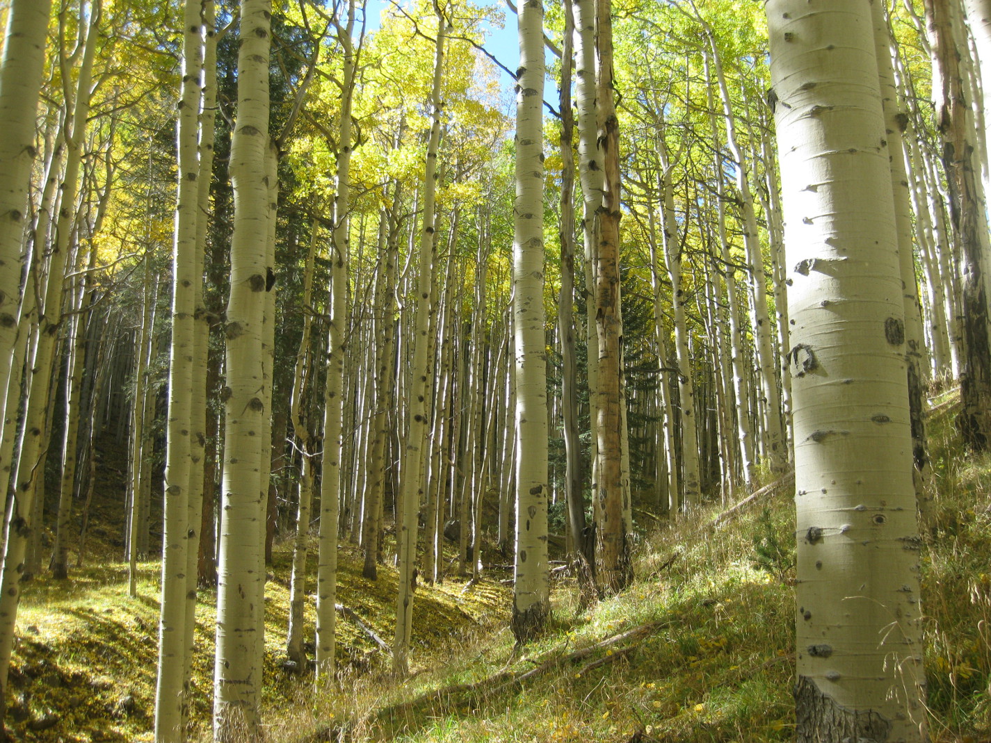 |
The aspen forest between Lockett Meadow and Waterline Trail
|
 This
part of the recently-constructed section of trail (right),
switchbacking its way through the aspens and rising about 300 feet in
0.7 miles, is alone worth the trip. I have never found a hike
anywhere that I enjoy more than this short section of the Inner Basin
Trail.
This
part of the recently-constructed section of trail (right),
switchbacking its way through the aspens and rising about 300 feet in
0.7 miles, is alone worth the trip. I have never found a hike
anywhere that I enjoy more than this short section of the Inner Basin
Trail.
While
still in the aspens we paused for a group photograph.
 |
Left to right: Kwi Johnson, Lila Wright, Connie Woolard and Frank Lombardo
|
When we arrived at
Waterline Trail we stopped for a snack and a short rest. While
paused we discussed what we knew about the history of Waterline
Trail. Basically, that turned out to be very little more than that
the road it follows is used to service a waterline that carrying
water to the city of Flagstaff. We knew that it started at Schultz
Pass, ran along the slope of the mountain east of Schultz Peak and
Doyle Peak, crossed the Inner Basin near Jack Smith Spring and
continued north along the slope below Rees Peak to end in Abineau
Canyon. No one had a good idea as to when the waterline was
constructed.
However, Lila Wright
later found that the City of Flagstaff has a website containing a
brief history of the water system.1
According to this source, “a 12 mile, 6-inch clay pipeline was
constructed from the Inner Basin through Schultz Canyon to a 2.5
million gallon reservoir located north of Flagstaff along what is now
Schultz Pass Road2”
was constructed after the city was incorporated in 1884. I have
no date for when the waterline from the Inner Basin actually went
into service, but it would likely have been soon after 1884. Also I
do not know when the waterline was extended north from Jack Smith
Spring around Rees Peak to capture water from the north slopes.
However, I have hiked that section of trail all the way to Abineau
Canyon and did not notice any remains of clay pipe such as are seen
all along the trail south of Jack Smith Spring. That would seem to
indicate a later date of construction.
After our short break
we headed south on Waterline. This section continues through the
aspen forest and is a very pleasant hike.
 |
Looking down Waterline Trail just south of Jack Smith Spring
|
We knew that we would
soon enter the 2010 burn area, so were determined to enjoy the
unspoiled forest while we could. Still, even after we entered the
burn area, about 1.1 miles from the junction with Inner Basin Trail,
we found Waterline a rewarding hike. We found ourselves following
along the edge of the burn area and passing in and out of untouched
sections of forest and those that had been completely destroyed.
Each has its own attraction.
 |
An area untouched by the burn seen along with a devastated area
|
In the burned-over
areas recovery was now well underway with some areas covered with
lush grass and others thick with new-growth aspen.
 |
Showing new-growth aspen and grass growing in the burn area
|
A few minutes before
1200, our planned lunch time, we came to a sunny spot sheltered from
the brisk, rather chilly wind and stopped a little early for lunch.
After eating, we decided to head back to the trailhead. We knew that
the narrow, one-lane road into Lockett Meadow would be heavily
congested on the way out and we were not absolutely certain that the
old road along which we had plotted our return hike was all still
there. Some maps had shown it as not going all the way to Waterline
Trail; we might have to hike cross country. Lastly, it would be a
good two-hour drive back to Cottonwood after the hike was done. So
we turned and headed back to where we thought the old road ran, just
at the beginning of the burn area.
We had some good views
along the way. Highway 89 was visible below us and we could see the
Painted Desert beyond Sunset Crater and across the Navajo
Reservation.
 |
Looking across the Navajo Reservation to the Painted Desert
|
 We easily found the old
road we planned to follow and followed it for 1.6 miles back to where
we were parked. It was steep running down the mountain, but
otherwise in excellent condition. And it did extend all the way to
Waterline Trail. We encountered several hikers and hunters walking
up the trail but no vehicular traffic at all except for a single ATV
parked behind a tree just above the road near Waterline Trail. When
we reached the foot of Sugarloaf Mountain, just where the road turns
west to make the final descent to Lockett Meadow, we encountered a
gate across the road and the following Forest Service sign (left)
that explained the general lack of vehicular traffic.
We easily found the old
road we planned to follow and followed it for 1.6 miles back to where
we were parked. It was steep running down the mountain, but
otherwise in excellent condition. And it did extend all the way to
Waterline Trail. We encountered several hikers and hunters walking
up the trail but no vehicular traffic at all except for a single ATV
parked behind a tree just above the road near Waterline Trail. When
we reached the foot of Sugarloaf Mountain, just where the road turns
west to make the final descent to Lockett Meadow, we encountered a
gate across the road and the following Forest Service sign (left)
that explained the general lack of vehicular traffic.
As we made the final
descent into the meadow, we caught our first glimpse of Humphreys
Peak, looming at the west end of the Inner Basin. Lined up along the north side of the Basin
were Abineau shown dimly through the trees in the center of the
photograph and Rees
Peak seen at the extreme right in the same photograph.
 |
Humphreys Peak (center)
|
 |
Abineau (center); Rees (right)
|
The road below the gate
blocking vehicular traffic was quite busy and we kept having to step
aside to permit cars to pass. Busy dodging cars and sorting out and
identifying the peaks, I was largely unaware of scenery closer in.
However, Lila drew my attention to the brilliant colors displayed by
a small group of aspens just off the road in the following photograph.
 |
Brilliantly-colored aspens at Locket Meadow
|
When we arrived back at
the meadow, we found that it was even more crowded than when we had
started our hike. All camping slots were filled and the trailhead
parking area was overflowing, with cars parked haphazardly along the
narrow roadway.
 |
Lockett Meadow camp slots and trailhead parking were filled to overflowing
|
One thing we noted
immediately on entering the camping area was that, despite the
overflow crowd, there was no line outside the toilet. Closer
examination, however, revealed a neat sign on the door telling us
that it was out of use due to the current government shutdown. That
and the inability to access the USGS National Map Viewer, which I use
to create maps for my hike reports, are the only problems I have
personally encountered during this first week of the shutdown.
My final GPS statistics
show that we hiked for 2 hours and 51 minutes and stopped along the
way for 1 hour and 51 minutes, for a total time of 4 hours and 42
minutes. The total round trip hike distance was recorded as 7.0
miles, the total ascent was 1554 feet and the highest elevation of
9,420 feet.
The GPS track for this
hike is shown on the attached topographic map (below).

1
http://www.flagstaff.az.gov/documentcenter/view/14325
2
http://www.flagstaff.az.gov/documentcenter/view/14325
No comments:
Post a Comment