On
Memorial Day 2012, eight campers from Sedona, the Village of Oak
Creek and Cottonwood descended into Tsegi Canyon and hiked to Keet
Seel Ruin.
Keet
Seel or Kiet Siel (roughly
“broken pottery scattered about” in
Navajo)/Kawestime
(Hopi)
is one of three Ruins included as part of the Navajo National
Monument. The others are Betatakin (“Ledge
House” in Navajo)/Talestima
(“Place
of the Blue Corn Tassels” in Hopi)
and Inscription House (Tsu’Ovi
or, “place of the rattlesnake, in Navajo).
Inscription House is closed to the public. Ranger guided tours are
available at Betatakin and Keet Seel.
The
primary purpose of our trip was to visit Keet Seel. We would drive
to the Navajo National Monument on Sunday the 27th and
camp overnight at Sunset View Campground, which has charcoal grills,
water and toilets facilities, hike the 8.5 miles to Keet Seel and
tour the ruin on Monday the 28th (Memorial Day). We would
then stay overnight at the nearby Keet Seel Campground, which has
composting toilets but no water, before hiking out the next day. On
our return from Keet Seel we would decide whether to stay another
night at the Sunset View Campground (or the nearby Canyon View
Campground, which has toilet facilities but no water) in order to
visit Betatakin Ruin before returning home on the 30th.
Part
of the group left Sedona at 0900 and met the rest at the Flagstaff
Airport parking lot to begin the 144-mile drive to the Navajo
National Monument. We stopped for lunch at the Cameron Trading Post,
where we were immediately seated, barely before a tour bus arrived
and a long line formed at the restaurant.
We
arrived at the Navajo National Monument Visitors Center in plenty of
time to select prime campsites in the adjacent Sunset View Campsite
and walk back to the center for the 1530 orientation, required of all
visitors to Keet Seel before a group visitors permit is issued. We
could have attended an early morning orientation the next day;
however, we intended to get an early start on our hike. Only 20
hikers are allowed to hike through Tsegi Canyon to visit Keet Seel
each day and we were told that, including our group, 18 were signed
up for the next day.
Sunset
View Campground was nice and quiet. Some members of our group played
a card game. The rest of us were in our sleeping bags by dark. Most
of the group had brought tents; I had decided to make do with a
waterproof sack that I normally use just for a ground cover, but that
can be opened to accommodate a sleeping bag, sort of like an
oversized pillow case. The temperature dropped to around 38 degrees
(a guess based on the NWS forecast) at the rim and most of our group
got quite cold that first night. As for myself, having suffered
through a cold, sleepless night during a March 2012 overnight trip to
White Pocket,
I was taking no chances; I was equipped with two reflective blankets
and had an extra sleeping bag in the car Just in case the rim proved
to be too cold. I donned long underwear, but didn’t need the extra
sleeping bag or the reflective blankets.
We
arose at first light the next day, ate breakfast, repacked our
backpacks, arrived at the Keet Seel Parking lot shortly after 0700
(MDT) and started our hike at 0720. The first half-mile of the hike
is along a dirt road from the Keet Seel parking area to the Betatakin
parking lot, which opens at 0800 and closes after the last daily tour
of Betatakin Ruin. At the Betatakin parking area, a locked gate
(bar) blocks the way ahead to vehicular traffic; however, a rough but
easily passable, dirt road continues for about another mile to Tsegi
Point, the start of the steep descent into the canyon. It is worth
pausing at the point for a few minutes to take in the view looking up
Keet Seel Canyon and noting the stream along which you will soon be
hiking.
 |
Looking up Keet Seel Canyon from Tsegi Point where the trail starts its
sharp descent.
|
A
sign posted alongside the trail notes that it is another seven miles
to Keet Seel, points out that the trail descends for 1000 feet “over
two sets of rugged switchbacks and sand” in the next mile from
this point and then ascends for 400 feet before ending at Keet Seel.
It also suggests what to wear, what to take with you and notes that
wood and charcoal fires are prohibited.
The
sign also provides a map of the trail (below).
 |
Map, displayed at Tsegi Point, showing the trail up Keet Seel Canyon
to the ruin
|
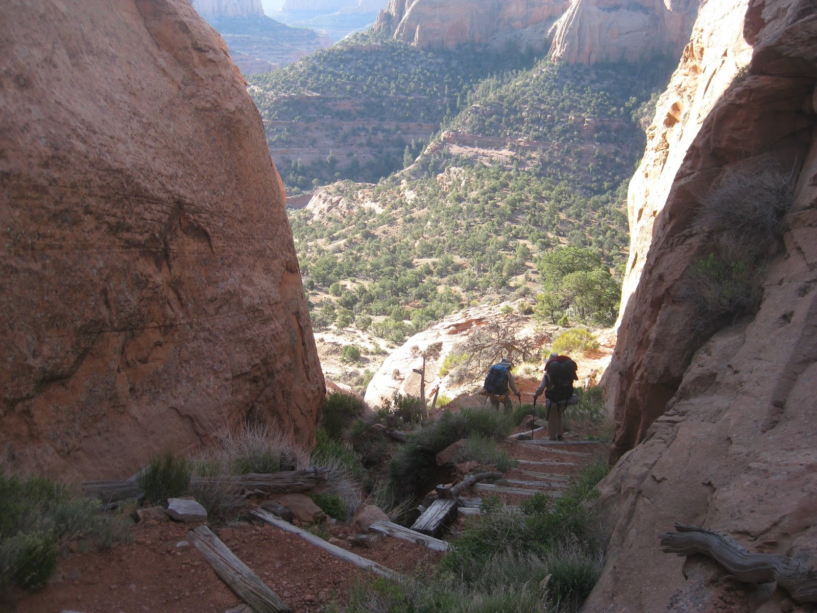
The
trail now becomes very steep. The following photograph shows a
section of trail formed by carving steps in the surface of the steep
rock face of the cliff.
 |
Looking back up the trail from just below Tsegi Point – the steps are carved
in solid rock.
|
A
section follows this with steps made from crossties. The step-down
from one crosstie to the next was about 18 inches, which is not a
serious problem going down, but would be very tiring coming back up
the trail. Fortunately, someone has placed a rock just below each of
the crossties. I really didn’t notice them on the way down, but I
certainly took advantage of them on the way back up the next day.
The following photograph illustrates this section of trail.
 |
Section of trail formed by the use of crossties
|
Looking
ahead, we could see the faint mark of the trail approaching the first
stream crossing, marked by a large rock (or boulder) on the far bank.
 |
Photograph taken just below Tsegi Point showing the trail below at the
first stream crossing
|
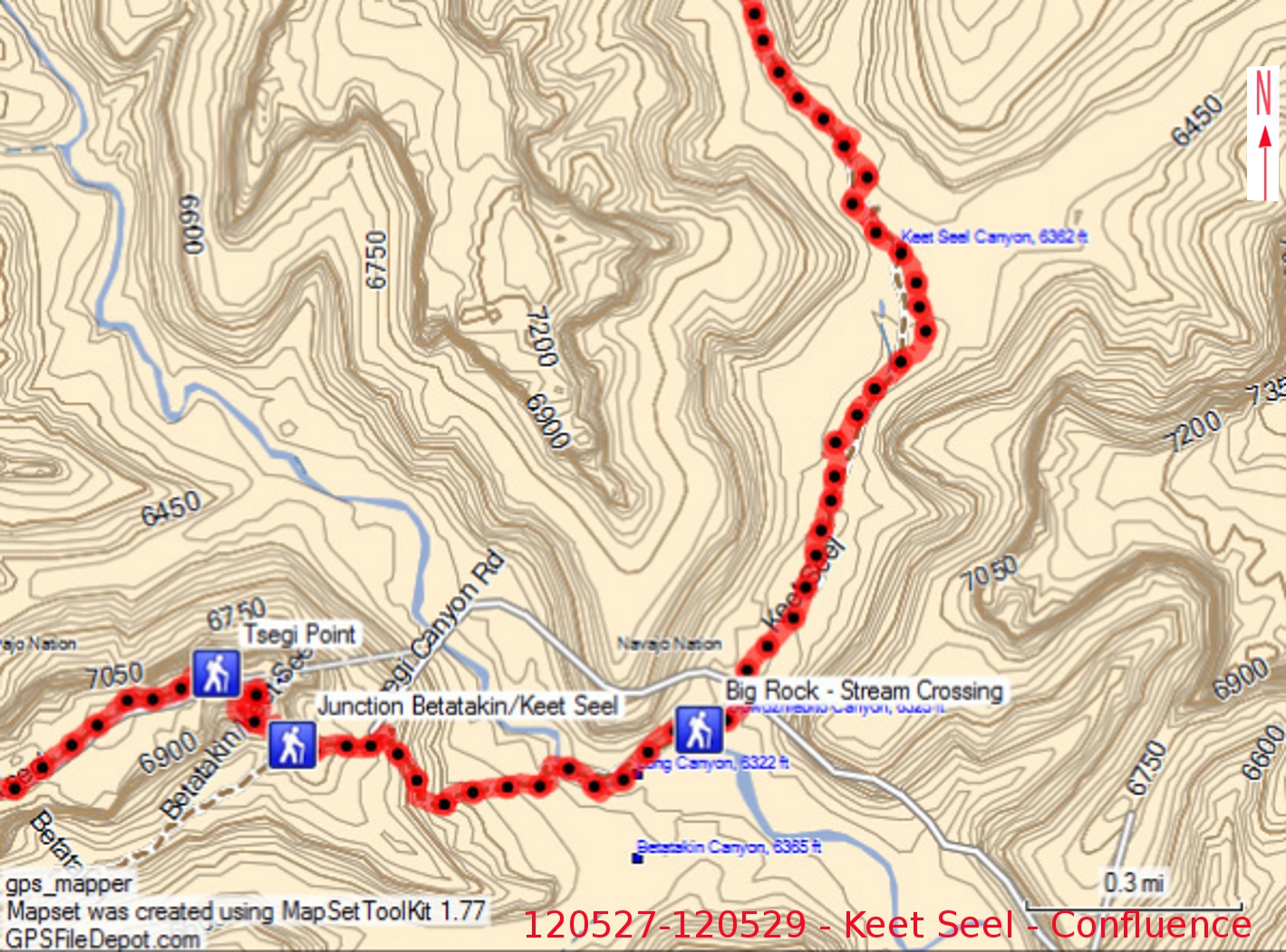
As
shown on the Map below, the trail descends from Tsegi
Point to the confluence of Long, Betatakin and Dowozhiebito Canyons
with Tsegi Canyon (Keet Seel Canyon drains into Dowozhiebito about a
mile upstream from the confluence).
 |
Showing the trail descending from Tsegi Point to the confluence and
heading up Keet Seel Canyon
|
About
0.2 miles from Tsegi Point, Betatakin Trail leads off to the
southwest. Continuing on down Keet Seel Trail, we crossed an old
steeply sloping sand dune, another section of switchbacks and,
finally, another old sand dune that sloped sharply down to the stream
at the mouth of Long Canyon. As we descended into the canyon, my
enjoyment of the view below was tempered a bit by the knowledge that
on the morrow, during the hottest part of the day, we would be
slogging our way back uphill through the loose sand of the dunes and
climbing the steps of the switchbacks. Oh, well, at least my pack
would weigh less than 25 pounds as opposed to the 40 pounds I was now
carrying, primarily because I would have either consumed or dumped
most of the two gallons of water I was carrying.
Our
group of eight had been given two copies of a trail map during the
orientation, one carried by Becky Fowski and the other by Lila
Wright. Lila had specifically requested a second copy with the
thought that some of the group might wish to forge ahead. Even so,
two of our group went ahead without a trail map, took a wrong turn
and added an extra mile or two to their hike. The remaining six
hikers in our group stayed within sight of one another until we had
passed the second, and most impressive, waterfall.
 |
Second waterfall shown on the trail map located on the sign at Tsegi Point
|
The
first fall, located at the mouth of Keet Seel Canyon, was so
unimposing that I didn’t even classify it as a fall until I later
noted that it was labeled as such on the Tsegi Point trail map.
Shortly
after we passed the second fall, we came to the beginning of the
upper trail, which climbs out of the streambed and follows along the
east canyon wall. A posted sign warns hikers of the danger of
flooding and quicksand in the streambed. The ranger had addressed
this during our orientation, telling us that the upper trail was in
“rough condition” and suggesting that we follow along the
streambed. However, thinking that it might be a nice change from
wading in the stream, I decided to give it a try. Although I found
myself hiking alone, the other hikers were still visible most of the
time in the streambed below. The trail I was on started out with a
steep climb up a dune through loose sand; but then it leveled out and
the loose sand was replaced by a good packed dirt surface.
Unfortunately, following the contour of the canyon wall, as it must,
the trail frequently dipped away from the main streambed to cross
washes along the way. These washes seemed to become ever deeper,
requiring more lengthy detours to find an acceptable trail crossing.
Also, the trail was washed out in some of the washes making crossing
very difficult. I finally came to one very pronounced wash where the
trail was so badly damaged that it required a perilous climb up a
steep slope and down the other side to cross over. I must have been
delayed for fifteen minutes in overcoming this obstacle.
At
this point, I could no longer see the streambed below and had no idea
where the other hikers were. Not wanting them to worry that I might
have had an accident while separated from the group, I pushed hard to
make sure that, if I didn’t regain sight of them below, I would at
least reach the end of the upper trail by the time they arrived at
that point. As it were, I never caught sight of them again until I
descended into what turned out to be a side canyon located at the
falls labeled as number four on the map posted at Tsegi Point. The
first two of the hikers who were following the streambed arrived at
the same time I did; they were headed upstream, neither they nor I
realizing that they had left the main canyon.
NOTE.
I later learned, from reference to the map, that the upper trail
supposedly extends for another two-tenths of a mile beyond where I
returned to the streambed on the Keet Seel Confluence map (above).
That would put its end very near to the campground entrance.
However, I did not see any sign of it coming out there. I did notice
what might have been the trail continuing beyond the point where I
turned off.
Knowing
that three other hikers were behind us and wanting to let them know
that I had returned safely from my side adventure on the “upper
trail,” I decided to take a nap alongside the trail and wait for
them to reach me. Just as I leaned against the soft, sandy bank and
pulled my hat over my eyes, I heard their approaching voices.
Several minutes later, I awoke to dead silence. Surely they would
not have passed by without awakening me. As I was still deciding
what to do, the first two hikers, having reached a dead end on their
fruitless trip up the side canyon, returned, and we all three made
our way back to the main canyon, climbed over the waterfall and
continued on to the campground, just three-tenths of a mile ahead.
We clambered (struggled might be more accurate) up the steep slope to
the inviting shade offered by a grove of oak trees, dumped our packs
at a picnic table and collapsed.
 |
Entrance to Keet Seel Campground
|
Looking
around, we found that three hikers who had been bringing up the rear
had already arrived, dropped their packs and continued the short
distance to check in at Keet Seel with the ranger. After a short
rest, we too started to the ranger station, but were met on the way
by Ranger Diane Boyer who informed us that a tour had just started
and that the next one would be at about 1530. It was now shortly
after 1400, so we returned to the shade of the oaks at the campground
and set up camp for the night.
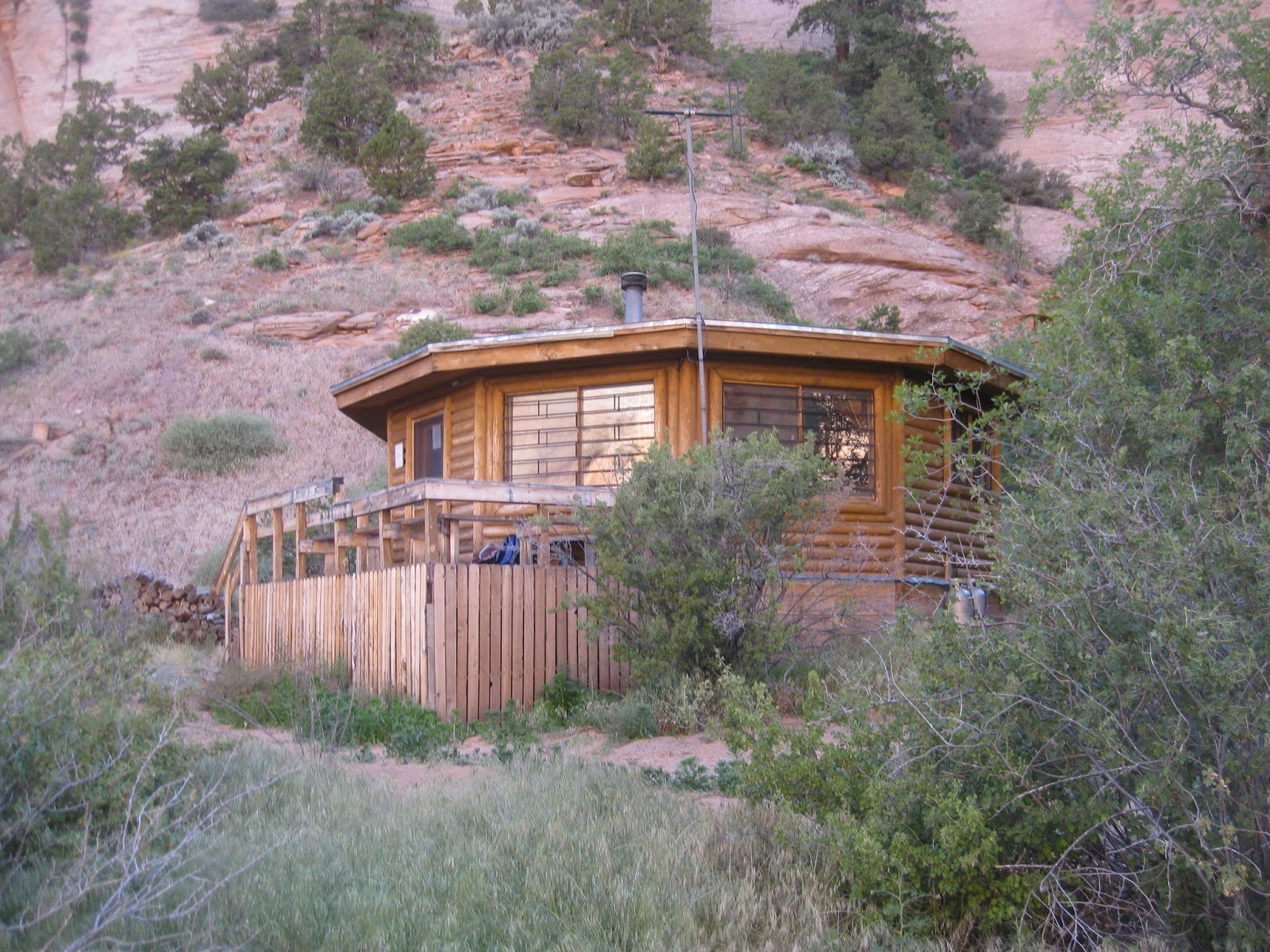
At
around 1500 we proceeded to the ranger station to wait for the next
tour. At the ranger’s residence we again met Diane and learned
that she along with her husband, Steve Hayden, were both volunteers
on a two-week tour at Keet Seel. Although very much isolated and
with limited services (Diane hiked out the day we left partly to make
a phone call), a tour of duty at Keet Seel must be paradise to a
lover of the outdoors. It amounts to a two-week working campout,
except that one is camping in a very attractive hogan provided by the
Park Service.
 |
Ranger’s residence at Keet Seel
|
Diane
directed us to a shady spot with picnic tables in an oak grove along
the trail between the residence and the ruin. Two benches are
installed a bit closer to the ruin, positioned so as to provide a
good look at the runs visible across a wash. We checked the benches
out, but they were in the sun and, after getting a first good look at
the ruin, we headed back to the shade to wait for our tour.
 |
View of Keet Seel Ruin across the wash from benches
|
According
to National Park Service publication (NPS/NRPC/GRD/NRR—2007/005),
“the
Wetherill brothers (part of a ranching family from Colorado),
who explored the cliff dwellings at Mesa Verde National Park, also
found the Keet Seel dwellings in 1895. Excavation of the site began
in 1897”
The
same source records that Navajo National Monument was established on
March 20, 1909 by Presidential Proclamation No. 873, issued by
President Taft. This was followed by Presidential Proclamation No.
1186 in 1912, adjusting the monument boundary to its present size of
360 acres. John Wetherill was the first park employee. Monument
headquarters are located on 245 acres of tribal land adjacent to the
Betatakin section.
Archaeologist
Julian Hayden wrote the following in an article published in the
Arizona
Archaeological and Historical Society’s
magazine, Kiva:
The great
Depression, with its unemployment, was at its height in 1933. It was
necessary to put as many men as possible to work, and the Civilian
Works Administration was set up for this purpose. Repair and
stabilization of a number of ruins within the purview of the National
Park Service fitted logically into the scheme of things, for many men
could be employed to good effect. Such ruins as Tuzigoot, Wupataki,
and Kiet Seel were in the program. Accordingly, a project was set up
for Kiet Siel with the museum of Northern Arizona as repository and
Hosteen John Wetherill as superintendent. Field Archeologists were
in very short supply, so my father and I, fresh from Casa Grande and
the Grewe Site, were recruited, he as archeologist, I as cataloger,
and we went to Kiet Siel. Base camp was at Marsh Pass, and we
packtrained up canyon to the ruin.
 When,
Steve, the ranger conducting our tour arrived, we learned that he was
the grandson of Irwin Hayden (archaeologist) and son of Julian Hayden
(cataloger) for the 1933/34 excavation. Julian had kept a detailed
diary, which Steve discovered and transcribed after his father’s
death. The diary recounts that Irwin Hayden walked off the job
before the excavation was completed due to a dispute over a
restoration project. Steve showed us a window-like opening built
into a retaining wall erected by the excavation crew. He said that
window (right)
was the subject of the dispute over which his grandfather left the
project. He basically repeated for us what he had already said in an
interview by a reporter. His words from that interview are presented
in the following quotation from a KNAU radio program transcript
written by Rose Houk:
When,
Steve, the ranger conducting our tour arrived, we learned that he was
the grandson of Irwin Hayden (archaeologist) and son of Julian Hayden
(cataloger) for the 1933/34 excavation. Julian had kept a detailed
diary, which Steve discovered and transcribed after his father’s
death. The diary recounts that Irwin Hayden walked off the job
before the excavation was completed due to a dispute over a
restoration project. Steve showed us a window-like opening built
into a retaining wall erected by the excavation crew. He said that
window (right)
was the subject of the dispute over which his grandfather left the
project. He basically repeated for us what he had already said in an
interview by a reporter. His words from that interview are presented
in the following quotation from a KNAU radio program transcript
written by Rose Houk:
"Gramps was
offsite when Milton [Wetherill, the crew foreman] undertook to
stabilize that wall," Hayden says. "He did it by building
an addition to the kiva that was to say the least un-Anasazilike.
When my grandfather came back and saw that he just had a hissy fit."
Steve’s
in depth knowledge of the site coupled with his friendly and engaging
demeanor made him an excellent tour guide and we felt extraordinarily
lucky to have made our trip while he was on duty. He discussed most
of the following information, quoted below from National Park Service
publication (NPS/NRPC/GRD/NRR—2007/005).
The Keet Seel site,
located up a north- south trending side canyon in the Tsegi Canyon
system, contains the largest cliff- dwellings in America: the Keet
Seel cliff dwelling … and the Turkey Cave cliff dwelling.
Many of the features
in Betatakin Canyon are present at Keet Seel. Like Betatakin, Keet
Seel has a spring at the contact between the Navajo Sandstone and
Kayenta Formation. Pictographs of birds are preserved in Turkey Cave.
Pottery and tree-
ring dating indicate that the ancient Puebloans lived here as early
as A.D. 950. Inhabitants of Keet Seal did not come in groups, as at
Betatakin, but arrived and departed randomly. As a result, Keet Seel
contains more variation in room design and construction and more
kivas than Betatakin.
A surge in building
activity in 1272 suggests the arrival of a new group of people.
Population growth apparently taxed the capacity of the alcove and
people began moving out. Those who remained converted abandoned rooms
into granaries; however, they also left around 1300.
Our
guide also pointed out, as does the previously quoted NPS
publication, that four American Indian tribes (Hopi, Navajo, San Juan
Paiute, and Zuni) have cultural associations with the area. Each
tribe “has
a distinct set of beliefs and a relationship with the sites,
geography, and landscapes of the monument.”
Steve
also told us that Keet Seel Canyon was once a lush area with marshes
and pools of water. The below quotation from the NPS publication
possibly alludes to this:
From carbon-14
dating of wood fragments near the base of the Tsegi, deposition began
around 5,389 years BP and ended about A.D. 1275- 1300. Erosion
removed extensive areas of the Tsegi, often to bedrock. Naha
deposition began after A.D. 1375 and continued until A.D. 1884.
Fresh- water gastropods, pelecypods, and ostracods have been found in
the Naha Formation (Briscoe 1974). A new cycle of erosion is in
progress today (Clay- Poole 1989).
We
were told that Keet Seel contained 150 rooms,
and could see that the structures (dwelling units, granaries, kivas,
etc) are still relatively well preserved. As we drew closer to the
site, these came into better focus
 |
View of Keet Seel as we approached
|
A
sturdy, well-constructed 70-foot ladder leads from the end of the
trail up to the ruin. The ladder, visible to the left in the
photograph (below),
tops out at the end of a retaining wall. Just to the right of the
top end of the ladder, a small opening, surrounded by a lighter, worn
looking area, can be seen in the retaining wall. This is a section
of the original wall. CWA workers rebuilt the rest of the wall seen
in the photograph. Just above the top of the ladder is seen a log
from a “great
white fir, 24 inches through at the butt and 30 feet long, … cut
down with stone axes … and man-handled up a 40 foot steep slope.”
It now separates a section of the ruin, to the left of the log,
which is basically untouched by modern hands from that which has been
restored.
 |
Ladder up to the ruin, ancient white fir log and section of original
retaining wall
|
As
we stepped off the top of the ladder, we saw a mortar and pestle (photograph below), located just to our
left near the rim of the retaining wall. A short distance away, we
found shards from intricately decorated pottery (photograph below lying about.
 |
Mortar and pestle
|
 |
Shards from decorated pottery
|
Looking
to the left from where we ascended we had a good view of the
unreconstructed part of the ruin. This section is closed off to
protect it from damage.
 |
Closed-off section of Keet Seel Ruin – still in original condition
|
Several
paintings were visible on the alcove ceiling above this section of
the ruin.
 |
Paintings located on the alcove ceiling above the untouched section of ruins
|
Looking
to the right from our position at the top of the ladder, we saw
buildings (dwellings, granaries and kivas) and retaining walls that
were a mixture of original construction and restoration efforts. The
workers closely followed the original style of construction and the
main differentiation now appears to be due to weathering, excluding,
of course, the “un-Anasazilike” window that caused Irwin
Hayden to walk of the project.
 |
Parts of the ruin have been restored/repaired by copying the original
construction methods
|
The
photograph shown below displays a mixture of original construction
and restoration.
 |
A mixture of original construction and restoration
|
 Some
of the walls were constructed of mortared stone; others were built
using the jacal (hä-käl) or wattle and daub method of construction.
“Walls
were woven like giant baskets between a series of upright wooden
posts. The entire structure was covered with mud.”
The photograph included here (right),
showing a deteriorated section of a dwelling at Keet Seel,
illustrations the jacal construction technique.
Some
of the walls were constructed of mortared stone; others were built
using the jacal (hä-käl) or wattle and daub method of construction.
“Walls
were woven like giant baskets between a series of upright wooden
posts. The entire structure was covered with mud.”
The photograph included here (right),
showing a deteriorated section of a dwelling at Keet Seel,
illustrations the jacal construction technique.
 In
one of the ruins we saw a handprint, apparently made with soot, on
the ceiling. It was in a very dark area and required a flashlight to
view. With much bending and twisting to insert my camera and upper
body through the small room opening while still keeping focused on
the location of the print, I finally managed to photograph the print
(left).
In
one of the ruins we saw a handprint, apparently made with soot, on
the ceiling. It was in a very dark area and required a flashlight to
view. With much bending and twisting to insert my camera and upper
body through the small room opening while still keeping focused on
the location of the print, I finally managed to photograph the print
(left).
We
also looked down into a well-formed kiva
 |
Looking down into a kiva at Keet Seel
|
It
was now fast approaching time for the ranger’s next tour, so
climbed back down the ladder, said farewell to Steve and Diane, and
made our way back to the campground. We left the ruin satisfied that
we had been well rewarded for the strenuous, 8.5-mile hike to get
there.
 The
campground was a most pleasant place and, primitive though it is, I
would have liked to spend another night there. It was fenced in to
keep cattle out and had two clean, well-maintained, unisex composting
toilets, placed in opposite sides of the building shown in the
photograph (right).
The
campground was a most pleasant place and, primitive though it is, I
would have liked to spend another night there. It was fenced in to
keep cattle out and had two clean, well-maintained, unisex composting
toilets, placed in opposite sides of the building shown in the
photograph (right).
We
had set our campsite up near a picnic table at the very edge of the
oak grove. Donna’s tent is shown in the following photograph, my
bedroll is placed beyond the picnic table seen just to the right of
her tent, and Lila’s tent is in the edge of the grove just to the
right of Donna's tent. Becky and the other four campers from
Sedona/Oak Creek were scattered at various locations in the shelter
of the trees. A picnic table is to the right of
 |
Camp setup at Keet Seel
|
We
relaxed for a few minutes and then ate an early dinner. I set up my
camp stove and heated water for my freeze-dried pasta vegetable
parmesan meal, and an after dinner cup of tea. No one else had come
prepared for hot meals. After dinner, we all placed our backpacks in
the nearby metal container to protect them from varmints, mostly
ravens the ranger said. I was asleep well before dark.
We
all arose at the crack of dawn the next morning, had a quick
breakfast and headed back down the trail. We were intent on
completing the 1000-foot climb out of the canyon before the hottest
part of the day.
 |
This is where I rejoined the streambed on the hike up the canyon
|
When
we reached the point where I had rejoined the streambed after my
misguided trip along the “upper trail,” I paused long enough to
take a photograph of the fall. A small stream from a side canyon
flows in from the right at the bottom of the fall. It is the one
mistakenly followed by the two hikers I had met at the end of my hike
on the upper trail the day before.
We
continued on down the canyon at what was for us a rapid pace, but
soon were overtaken by Diane, one of the rangers, who was hiking out
to post mail and make a phone call. She chatted for a few minutes
and then, saying she had to be going, left us in the dust, or what
would have been dust if we weren’t hiking in a stream.
We
Passed a nice patch of primroses freshly blossomed in the early
morning sun and saw a log lodged on a rock, which the ranger had
mentioned as marking a recent high water point.
 |
Primroses blooming along the stream bank in Keet Seel Canyon
|
 |
Log lodged on a rock during the last flood
|
 Normally,
we try to get everyone together at some point during a hike for a
group photograph, and it suddenly dawned on me that we had not done
that yet. Two of our hikers had, like yesterday, surged ahead, so I
hurried to catch them, passing Diane on the way. I finally caught
them and we waited a few minutes for the rest of the group, but then
decided to take a separate photograph of the two of them so that they
could be on their way (left). The
hiker on the left is Pam Greene; Cathy Lutz is shown to the right.
Normally,
we try to get everyone together at some point during a hike for a
group photograph, and it suddenly dawned on me that we had not done
that yet. Two of our hikers had, like yesterday, surged ahead, so I
hurried to catch them, passing Diane on the way. I finally caught
them and we waited a few minutes for the rest of the group, but then
decided to take a separate photograph of the two of them so that they
could be on their way (left). The
hiker on the left is Pam Greene; Cathy Lutz is shown to the right.
I
then managed a nice nap while waiting for the rest of the hikers to
catch up so that I could complete the group photography.
 |
Left to right: Donna Goodman, Lila Wright, Becky Fowski, Phyllis Elliot
and Barbara O’Connor
|
 Then,
just to make sure everyone was accounted for, someone used my camera
for a photograph of me (right).
Then,
just to make sure everyone was accounted for, someone used my camera
for a photograph of me (right).
After
the photography sessions, we continued on our way down the trail,
making only one other significant stop, and were soon crossing the
stream for the last time for the climb back across the sand dunes and
switchbacks on the 1000-foot ascent to Tsegi Point.
Lila
and I had both stashed water at the bottom of the first dune, but
didn’t really need it. We used it to water some nearby flowers and
headed on up the trail, actually finding the going a little easier
than we had anticipated.
The
following two photographs were taken during the climb back to Tsegi
Point.
 |
Becky, Lila and Donna trudging up the soft sand trail on the climb to
Tsegi Point
|
 |
Donna and Becky navigating a switchback on the climb to Tsegi Point
|
We
arrived back at the trailhead just about five hours after leaving the
Keet Seel Campground. We had not yet eaten lunch and decided to
drive on to eat at Taco Bell in Tuba City. We had long since decided
against spending another chilly night on the rim in order to visit
Betatakin the next day. At Taco Bell, I had a vegetarian taco and,
surprisingly enough, found it to be acceptable, possibly because I
was so hungry by then.
This
hike was one of the most rewarding I have done. The tour of Keet
Seel was both interesting and educational, and the trip there and
back was not nearly as difficult as I expected from reading reports
written by others.
The
entire 8.5-mile route of the hike is shown on the map included on the
next page. The basic hike is shown in red; the upper trail that I
hiked on the way up the canyon is shown in blue; and the short yellow
section near the top is the part of the upper trail that I did not
hike.
Miscellaneous
comments:
If
you make this hike, be sure to take enough water, but stash some of
it along the trail on the way in. I carried the recommended two
gallons when I started and made two stashes along the way. I also
brought along chlorine dioxide tablets just in case I needed to treat
contaminated water overnight. Treatment this way does require a bit
of forethought, as the dwell time is four hours. However, water was
not a problem with any of us, possibly because the temperature in the
canyon never got above the high eighties.
Most
of our group ate cold meals both nights we were camped out, although
we camped with our vehicles nearby the first night, and bringing
along stoves would not have been a problem. As for myself, I carried
a lightweight propane stove and freeze-dried meals. I find these to
be quite tasty as well as lightweight.
Some
of our group carried tents into the canyon and some just spread their
sleeping bags on tarps (or light plastic sheets). We were all quite
comfortable the night we spent at Keet Seel Campground.
Our
group did not stay together during the hike and some members made
wrong turns on the way in as well as on the way out. The rangers
normally provide only one copy of the Keet Seel trail map. My
suggestion is that everyone maintain contact with the person carrying
the map. Hiking up a streambed in the bottom of a canyon sounds
straightforward; however, as amply demonstrated by our group, there
are a few places where one can easily follow the wrong stream or fail
to turn off at the appropriate point.
Finally,
the upper trail, which I unwisely took on the way up the canyon, is
pretty difficult, even dangerous in at least one place, because of
the requirement to climb around or across washed out sections in the
washes. If I were doing the hike again, I would take the upper trail
only if real flooding danger existed, as might be the case during the
monsoon season.
Finally,
thanks to Becky Fowsky for arranging this very rewarding trip.
The
8.7-mile hike to Keet Seel is, except for the 1000-foot drop into
Tsegi Canyon, and a 400-foot climb approaching the ruins, almost
level, showing just a gentle upslope along the canyon floor, broken
with the occasional climb across a low hill formed between bends in
the stream. We were on the lookout for quicksand during the frequent
stream crossings but did not encounter any.
Our
track for this hike, including my ill-advised trek along the upper
trail on the way in, is shown on the included map (below).

 Continuing
on up the trail we came to a junction with Trails 537 and 538 about
0.5 miles from where we had turned and started northeast (or 1.2
miles from the trailhead). We had changed course and were traveling
east at this point. From this junction, Trail 536 headed to the
southeast, Trail 538 led to the northeast and Trail 537 headed
northwest. A sign was posted alongside 536 warning that it
dead-ended ahead. We nevertheless continued for another 500 feet
until the trail stopped at an old logging road (right).
Continuing
on up the trail we came to a junction with Trails 537 and 538 about
0.5 miles from where we had turned and started northeast (or 1.2
miles from the trailhead). We had changed course and were traveling
east at this point. From this junction, Trail 536 headed to the
southeast, Trail 538 led to the northeast and Trail 537 headed
northwest. A sign was posted alongside 536 warning that it
dead-ended ahead. We nevertheless continued for another 500 feet
until the trail stopped at an old logging road (right).