Monday, February 29, 2016

Yeager Mine Trail


Fifteen Skyliners hiked on Yeager Mine Trail on 27 February 2016. The day was perfect for hiking, with the merest dusting of wispy clouds on the far horizon. We left the Cottonwood Safeway parking lot just a couple of minutes after 0800 and headed across the mountain, traveling south on Hwy 89A. About 21.3 miles from the parking lot, we turned left onto a dirt road. This road is identified as Forest Road Road 643 on the Motor Vehicle Use Map1 but as Forest Forest Road 151 on another Prescott National Forest map2. It may also be referred to as Powerline Road. In any case the first 0.9 miles of the road, to the junction with FR 9002S (Yeager Mine Road), is heavily traveled and maintained in excellent condition.

At the Yeager Mine Road turnoff we found the following signage.

Signs posted at the Yeager Mine Road turnoff
The Mingus Mountain Academy sign shown in the photograph (above) elicited some curiosity and after a little research I found it describes itself as a “residential treatment center for emotionally and behaviorally at-risk adolescent girls.” The mountain lion shown on the sign is the symbol of “a student-run organization, similar to a high school student government.I have never actually visited there but the campus looks quite impressive from afar. The below photograph was taken at a distance from Forest Road 643, perhaps half a mile south of the sign.

Mingus Mountain Academy – photographed from FR 643 on 20 February 2016


Forest Road 9002S (Mingus Mine Road), although less well-maintained than the dirt road from Hwy 89A had been was still navigable by passenger cars for the first 0.3 miles. We then came to a fork in the road with a sign (right) indicating that Mingus Mine Road veered off to the left and became a private road. We still had not reached the old Yeager Mine site and according to the maps I consulted in planning this hike, the forest road continues well beyond that point. That could only mean that Mingus Mine Road and the forest road split at this point with FR 9002S continuing straight ahead.


However, I had scouted the area earlier and noted that the road ahead, although still suitable for 4-wheel drive vehicles, was quite rough. In addition, a trail sign (left) at the fork indicated that Trail 501 (Mingus Mine Trail) started there. I had been surprised at finding the sign at that spot because all of my maps showed the trail starting about 0.8 miles ahead at the end of FR 9002S.

Parking where the private road branched off, we hiked 140 yards up the forest road to the old Yeager Mine site for a group photograph.

Left to right: Gary Jacobson, Bob Rauen, Floyd Gardner, Lila Wright, Dolly Yapp, Loren Pritzel, Colleen Maktenieks, Daisy Williams, the author, Jim Gibson, Karl Sink, Dave Beach and Jim Manning – two hikers not shown
Yeager Mine was an underground Cu-Au-Ag mine, owned by the Shannon Copper Company, and was in production during the period 1890-1949. “Workings included an inclined shaft to the 1300 level, drifts extending mostly to the East a maximum of 750 feet. Production was 9,627,987 pounds of Cu; 2,466 oz. Au; and 77,134 oz. Ag (to 1919). Additional 800 tons of Cu-Ag ore in 19223.

Little is left of the Yeager Mine site, just some indentations in the earth and a few battered found-ations where massive machinery once stood (right). The shafts have been filled in for safety reasons and the slag piles have largely been flattened and eroded so as to largely blend into the terrain.

From just above the mine we could look back across it and on across Prescott Valley to the mountains beyond.
Looking across Prescott Valley, Yeager Mine is visible at left (see bare spot)
After visiting the mine we trudged on up the forest road, crossing a property boundary line and entering Prescott National Forest. We passed the remnants of an old abandoned dwelling with associated outbuildings on our right and, just across the road from it, what appeared to be a old filled-in prospect site.

About 0.8 miles after leaving Yeager Mine we came to a fork in the road. The road to the left was quite distinct and appeared to be fairly well traveled. The right fork (red arrow below), showing less sign of travel, led straight up the spine of a ridge that separated two washes.

The arrow just above the resting hiker points to the correct trail
This is the point where, according to my reference maps, FR 9002S ends and Yeager Mine Trail starts. A Trail # 501 sign (left) was posted to show the way and this sign, unlike the one we had seen at Yeager Mine, prohibited all but hikers, equestrians and mountain bikers. Jeeps, ATVs and other motorized vehicles are prohibited. However, someone has pretty well obliterated the part of the sign that prohibits ATVs. There is left only a faint end of the red line that ran through through the ATV symbol.

Another 0.4 miles, consisting of a steep 400-foot climb along the spine of a ridge, brought us to the junction of a short side trail that leads to Tunnel Spring. I had noted this spring on the map and was determined to explore it. The distance to the spring turned out to be about 0.1 mile and the first 100 yards was wide, clear and easy to hike. The rest of the trail was a little overgrown in a few spots but never difficult to follow. What we found when we arrived was a seep spring. A closer examination indicated that the seep had at some time in the past been dug out by tunneling into the side of the mountain and a pipe had been inserted to channel the flow of water into a series of narrow watering troughs. Although water no longer flows from the pipe (below right) and the troughs (below left) are now empty and discarded, there is enough left to tell the story of what once was.


We paused for a short time at the spring before returning to the main trail to resume our sharp climb up the mountain. On the way out I stopped to photograph two of our hikers (right) making their way through the most overgrown portion of the short Tunnel Spring Trail.


Back at the main trail we took a head count and found that we were missing a hiker. This had so far been an easy-to-follow trail except for the single somewhat confusing spot where the trail had turned up the ridge spine between washes. We had thus not worried too much about being a bit spread out. Now, we were in a quandary. Had the missing hiker gone ahead, had he turned back or had he wandered off the trail for some unknown reason? We called his name, sent a hiker back to the spring to look for him and sent people ahead to see if he had continued up the trail. Finally, we found that he had turned back without telling anyone when he reached the overgrown section of Tunnel Spring Trail and, rather than wait for the group, had continued on up the trail by himself.

While waiting for our lost hiker to be found, I took a series of photographs that I could stitch together for a panoramic view across the valley from the trail junction, an elevation of 6340 feet.

View from the junction of Mingus Mine Trail and Tunnel Spring Trail
Once we were all back together we headed on up the trail for lunch at a saddle above Mingus Springs. To reach there we hiked another 0.7 miles and climbed about another 450 feet, ending at an elevation of 6893 feet. I found a sunny spot with a cushion of grass and had a nice long nap after lunch.
Someone asked whether it would be possible to access the upper Yeager Mine Trailhead by vehicle. The answer is yes with a caveat that the last 0.7 miles requires a 4-wheel drive vehicle. I had, as a matter of fact, done just that last November. It is therefore possible to position passenger vehicles at both ends and hike this trail one way. This would be a short hike of only 3.2 miles. That distance would include the 0.7 miles required to reach the upper trailhead from a place where a passenger vehicle could be parked as well side trips to explore Tunnel Spring and Yeager Mine.

To reach the upper end of the trail by passenger vehicle from the Cottonwood Safeway parking lot (map below), travel south on Hwy 89A for 15.2 miles, turn left onto Forest road 104 and go 1.5 miles, turn right on FR 413 and go 2.3 miles, turn right on FR 132 and go 0.4 miles then turn right onto FR 105 and go 0.7 miles and park at the intersection with FR 9626A. From there it is another 0.7 miles by foot or by 4-wheel drive on FR 9626A to the upper Yeager Mine Trailhead.

How to access the upper Yeager Mine Trailhead by road
On the map shown below the two short sections of blue track at either end of the trail (red track) are the forest service roads by which Yeager Mine Trail may be accessed. The road accessing the lower end of the trail is Forest Road 9002S and the one accessing the upper trailhead is Forest Road 9626A. The lower trailhead is accessible by passenger vehicles; to access the upper trailhead, passenger vehicles should be parked at the junction of FR 105 and FR 9626A. From there it is only 0.7 miles by foot or 4-wheel drive to the trailhead.

For the lower end of the trail, the map shows a “new trailhead” and an “old trailhead”. The old trailhead is where all the maps I found indicated the trail started; the new trailhead is where we found the first posted sign indicating that we were on Trail 105 (Yeager Mine Trail).

The red track on the map shows our track on the way up the trail and includes side trips to the old mine site and to Tunnel Spring. It measures 2.5 miles in length. Our return journey, without the two side trips, was shorter and the entire hike measured only 4.3 miles. The highest elevation was 6893 feet and the total ascent was 1365 feet.


1Motor Vehicle Use Map, Prescott National Forest, 01 August 2012
2Prescott National Forest “map”, published 1993, revised in 2000

3 http://www.mindat.org/loc-41726.html

Tuesday, February 23, 2016

Grapevine Gulch Trail Update


This is an update to the report of an 18 February 2015 hike on Grapevine Gulch Trail. That 2015 hike was made by the author, Lila Wright and Karl Sink for the purpose of scouting an unfamiliar trail.

This updated report, based on a 20 February 2016 hike by the Skyliners identified below, will add some information on an old mine, identified only as Cobalt shaft; Cobalt prospect; Walker prospect [?]1, we saw along the way and show a photograph of the water level in Concrete Spring.

We paused at Grapevine Well, a spot marked by a corral, a windmill and a large metal water storage tank, for a group photograph. The photograph was taken with the authors camera by a hiker who chose to remain unidentified.

Left to right: Floyd Gardner, Karl Sink, Dolly Yapp, Lila Wright, Jim Gibson, Dave Healey, Daisy Williams, Joanne Hennings, the author and Jim Manning
About 1.2 miles up the gulch from the windmill, we came to the misnamed Cement Spring, misnamed because it really is more of a well than a spring. I leaned into the opening and took a photograph (below left) showing the water level. About 0.5 miles on up the gulch from the spring we came to a mine tailings pile on the left side of the trail (below right). This marks the site of the old Walker cobalt prospect mine.

Looking into Cement Spring
 (or well)
Mine tailings at Cobalt
prospect mine
 We had only looked at the tailings pile last year. Now we explored a little further and found that an opening still exists at the apex of the tailings pile. Floyd is shown crouched in the opening (below left). The 28-foot opencut leading to the mine entrance is completely filled with rubble. By inserting my camera into the opening and using a flash, I was able to photograph the partially-filled tunnel (below right).
Floyd at mine entrance
Inside the mine
According to the Prescott National Forest web site, Grapevine Gulch Trail is 2.3 miles long, begins at Forest Road 9002V and ends at Trap Spring. The site provides no additional information. In fact the trail shows no indication of ending at Trap Spring and apparently continues on to Ash Creek just below Mingus Springs. From there it follows, according to a report I located on HikeAZ.com2, down Ash Creek almost to Ash Canyon before looping back to rejoin the trail in Grapevine Gulch just 0.2 miles above Trap Spring. Overcome by a bout of curiosity, I used a GPS track included in the HikeAZ.com report to measure the distance from Trap Spring to the point where it intersected with the track of a 07 November 2015 Skyliner hike on Ash Creek. It was just 2.2 miles.

While on the 2015 scouting hike we actually continued for another 0.7 miles beyond Trap Spring; when we turned back, the trail was still clear and appeared to be well-traveled. The map published with that report shows the point where we turned back and also includes the GPS track for the trail on to Ash Creek.

The red GPS track on the new map (see below) included here shows only our track for this update. Additionally, it corrects the location of the Walker cobalt prospect mine. The earlier map shows the mine as being co-located with Concrete Spring when it is, in fact, located another 0.4 miles upstream from the spring.


NOTE: The February 2015 report which this report updates can be found at http://ellisfprice.blogspot.com/2015/07/scoutinggrapevine-gulch-trail-ihad.html


1http://www.mindat.org/loc-46250.html

2 http://hikearizona.com/map.php?PSID=33313&GPS=27782

Tuesday, February 16, 2016

Kel Fox Trail - Update


On 6 February 2016, the Skyliners hiked Kel Fox Trail. We had previously hiked the trail on New Years Day in 2011. I wrote a report for that hike, so I will simply add a few additional comments here and republish that 2011 report,.

The first comment concerns the start of the hike. In the original report I provided directions to the paved parking area and described the start of the trail. I have now added a photograph showing the gate (see red arrow, below) intended for hiker use. Apparently, hikers are supposed to use this gate, to exit to the road right of way along CR 78 (Beaverhead Flat Road), follow a non-existing trail for about 100 yards to the intersection with Old Beaverhead Flat Road (a dirt road) and then recross the fence through a similar gate located adjacent to a cattleguard in the dirt road. However, it is much easier to just pass along the left side of the gate, follow along the inside of the fence and access the dirt road just beyond the cattleguard.

Hiker gate leaving parking area

On the return hike we saw a large, isolated boulder, lying in the center of a clear, grassy area. The boulder seemed somehow out of place, lying there in splendid isolation. This was the fourth time I had passed this way, the last time just a couple of hours earlier, but the first time I had taken note of the boulder. It is located in the saddle above Fuller Tank about 1.1 miles from the trailhead on Arabian Road and some 85 yards west of the trail. It was now almost noon and this area afforded us clear views north into the Red Rock Country and south all the way to the distant mountains in Tonto National Forest, so we decided to stop for lunch.

On approaching the boulder, we found that it contained Indian petroglyphs, some sort of abstract (at least to me) design along with a picture of an animal (see red arrow, below) such as might have been made by a small child. The abstract carving, composed primarily of neat, straight lines was rather appealing. On the other hand the Indian who drew the animal needed a few more art lessons.

Isolated boulder with Indian drawings

On the 2011 hike we had stopped for lunch just 160 yards from our present location and had then turned back without continuing to the Arabian Road trailhead. This time, we hiked the entire length of Kel Fox Trail . For this reason, as well as to show the location of the petroglyphs, I have included a revised trail map.

The actual one way trail distance, starting where we parked off Beaverhead Flat Road and ending at Arabian Road in the Village of Oak Creek, is 3.5 miles. Our round trip hike distance, including the detour to the petroglyphs and another small detour, was 7.2 miles, the maximum elevation was 4277 feet and the total ascent was 1285 feet.

Our GPS track, including the detour to the petroglyphs, is shown in red on the below map.


NOTE: Starting below, the entire 2011 hike report is appended to this update.


Kel Fox Trail


To start the New Year off right, eight Skyliners hiked on Kel Fox trail on New Year’s Day, 2011.

I was asked to include in the hike report some information about the rancher for whom the trail was named. With a little research, I unearthed SCR1012 - 441R, Kel Fox; death resolution1, a concurrent resolution of the Arizona Legislature:

The Honorable Kel Fox passed away on May 15, 1998, at the age of eighty-five.

Born in Stamford, Connecticut in 1912, Kel Fox moved with his family to Arizona in 1922 where his family established the Foxboro Summer Camp near Sedona. As a rancher and farmer, he served as president of both the Yavapai and Coconino Cattle Growers Associations and was active in the Arizona Cattle Growers Association and the Arizona Game Protective League. He also was active in the Sedona Chamber of Commerce and the San Francisco Press Club.

Known as a gentleman and a scholar, Kel Fox graduated cum laude from Princeton with a baccalaureate degree in history in 1935. He later attended the University of Arizona where he received a doctorate degree in agricultural sciences. During World War II, he ably served his country in the United States Coast Guard.

In 1939, Kel Fox embarked on more than fifty years of public service to the State of Arizona through his efforts as executive secretary for Governor R.T. Jones. He was subsequently elected to both the Arizona House of Representatives and the Arizona Senate, serving from 1946 to 1954. As a legislator, Kel Fox was a main force behind the construction of Interstate 17 and providing rural counties with electricity. In addition to his outstanding legislative service, Kel Fox also served the state as a member of numerous commissions and boards, including Water Quality Control, the State Board of Appeals, and Watershed Management.

Kel Fox will be sorely missed by his family, many friends and the citizens of the State of Arizona. Therefore.

Be it resolved by the Senate of the State of Arizona, the House of Representatives concurring.

From Cottonwood, we traveled north on Hwy 89A, took Cornville Road through Cornville and, just after passing milepost eight, turned left on Beaverhead Flat Road (sometimes labeled Beaver Flats Road).

We continued on Beaverhead Flat Road about five miles before turning left to park in a paved lot just a few yards from the road. We paused here to take a group photograph before starting our hike.

Left to right: Daisy Williams, Lila Wright, Betty Wolters, Donna Goodman, Jim Manning, Gordon Bice – the author and one other hiker are not shown
A clearly visible trail leads east from the parking area passing, several yards ahead, between two plaques, one on either side of the trail. The plaque mounted on the left side of the trail (see right), describes the Chavez Trail running from Prescott to Winslow. The Sunset Crossing mentioned in the plaque was near present day Winslow. As a matter of fact, until just a couple of years ago, the overpass (west of Winslow) that carries Interstate Highway I-40 over the Burlington Northern Santa Fe (BNSF) Railway had a sign that identified that spot as Sunset Crossing.

I assume this plaque, mounted on the right side of the trail (see left), is intended to credit those listed thereon with providing the parking area. Information available on the website of a local inn2 indicates that the section of trail starting here and following a natural gas pipeline east to the bottom of the hill where the pipeline then turns north is Beaverhead Flat Trail. However, the Verde Valley Regional Trails Plan (VVRTP)3 doesn’t show Beaverhead Flat Trail extending that far to the east.

Trail names aside, soon after passing between the two plaques we arrived at a fence fitted with a pedestrian gate. However, instead of passing through the gate we continued on by and traveled more or less parallel to the fence for about 100 yards to come out on a dirt road running parallel to Beaverhead Flat Road and the gas pipeline. (NOTE: One can access this road by vehicle just a few yards from where we turned off to park, approximately at milepost 5.2.) Counting from the parking lot, we followed this road for about three-quarters of a mile to a fork in the road. The natural gas pipeline ran along the road to our left and we went that way, continuing for another seven-tenths of a mile to the end of the road at Fuller Tank. This road is marked as FR 9500N, identified by the same local inn website quoted previously, and is so labeled on the Verde Valley Regional Tails Plan. An article in Sedona Monthly4, on the other hand, identifies the road as FR 9501L all the way from Beaverhead Flat Road to Fuller Tank.

Whatever the official road designation, it is an easy hike and can be driven in any high-clearance vehicle all the way to Fuller Tank. As a matter of fact, most descriptions of Kel Fox Trail that I have seen are based on driving to the tank to start the hike.

The presently existing Kel Fox Trail (see right), as shown by the Verde Valley Regional Trails Plan runs from Fuller Tank to Arabian Road in the Village of Oak Creek. The VVRTP also shows a proposed Kel Fox loop that would cross and run parallel to and east of Hwy 179, connecting the trailhead at Fuller Tank to the trailhead at Arabian Road in the Village of Oak Creek.

Looking ahead from FR 9500N as we approached Fuller Tank, we could see outcroppings of red in a rock-capped mountain straight ahead of us. Fuller Tank is located to the left of this mountain that forms one side of the saddle that contains it.

Looking ahead from FR 9500N. Kel Fox Trail starts at Fuller Tank, located in a saddle to the left of the mountain shown here.

FR 9500N ends at the dike creating the tank and Kel Fox trail starts there. To access the trail from the road one has only to walk across the dike and follow the pipeline markers along the hillside toward the crest of the saddle. It is tempting to continue along the east side of the tank from the end of the road rather than crossing over, as there is a well trodden cow path there; however, as we could see while hiking up the other side of the draw, it eventually fades away and would have left us to bushwhack on up to the crest.

Before leaving the area, we paused for a short break at the tank to catch our breath, look around at our surroundings, look back at the way we had come and look ahead at where we would go. The tank was nearly dry at the time of this visit. We had expected that it would be brimming with water after the recent rains, and we could only surmise that it is no longer maintained and thus does not hold the runoff. At least it does still serve as a miniature wetland, retaining at least some moisture.

Following are a few photographs of the area and a shot of the view behind us.

Jim Manning shown on the dike at Fuller Tank. Kel Fox Trail leaves the end of the dike beyond Jim and follows the pipeline along the slope to the right.
Looking down into Fuller Tank from the dike. At least a small wet area remains.

Looking back the way we came from the dike at Fuller Tank

Continuing on for about eight-tenths of a mile, we approached the saddle crest.

Looking out over the Village of Oak Creek to the snow-capped red mountains in the distance

Leaving the trail we climbed a short distance up the west flank of the saddle to find a sunny lunch spot with a good view:

Looking across Oak Creek Village to the snow-capped red rocks beyond. Cathedral Rock is visible in the upper left section

The Village of Oak Creek, Courthouse Butte and Snow-capped red rocks beyond
Kel Fox Trail is only about one and eight-tenths miles long and from where we stopped it was still a mile to the trailhead on Arabian Road in the Village of Oak Creek. However, including our hike up FR 9500N to reach the start of the trail, we had already almost two and one-half miles to reach the spot where we ate lunch, and we decided to turn around there and make an easy day of it. After all it was New Years Day and we didn’t want to start the new year by tiring ourselves out.

According to my GPS track, this hike was five and four-tenths miles round trip and the elevation change (highest to lowest) was around 635 feet.

To access the trail from the Village of Oak Creek, turn off Hwy 179 onto Rojo Road, go about two-tenths of a mile to a fork and turn left. According to the map I consulted, you will still be on Rojo Road. Continue for just over 200 yards and turn right on Arabian Road. You should find the trailhead on the left just over 100 yards ahead.

On the below map, I have shown our hike in red and sketched in the part of Kel Fox Trial that we did not hike in green.


Sunday, February 14, 2016

Twin Pillars, Twin Peaks & Turkey Creek Sinkhole


A bright morning sun highlighted the remaining patches of snow on Mingus Mountain when we gathered in the Cottonwood Safeway parking lot on 13 February 2016 for our scheduled hike.

We planned to start and end our hike at the junction of Verde Valley School Road and Turkey Creek Road (Forest Road 216B). Note that some maps may show Verde Valley School Road ending at the turnoff to Verde Valley School, 3.1 miles from Hwy 179, and call the rest of the road Red Rock Crossing Road. In any case, it is 4.1 miles from Hwy 179 to FR 216, so just stay on the main road. Our chosen parking area was still 0.5 miles from Turkey Creek Trailhead, perhaps a more logical place to start the hike, but we were unsure of the condition of FR 216B and the hike would anyway be fairly short.

We donned our packs, set out at what was for us a brisk pace and were soon at the Turkey Creek Trailhead. A relatively new sign (below left) pointed us into the parking area and a much older sign (below right) pointed out the start of Turkey Creek Trail.

Sign pointing to  parking 
Old metal trailhead sign   
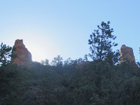
We intended to repeat a hike that some of the party had done in February of 2009. From the trailhead we hiked south for 0.4 miles on Turkey Creek Trail before turning southeast onto a well-traveled social trail. Our hike leader in 2009 had told us it was Twin Peaks Trail. I have since learned that some maps show it as Twin Pillars Trail. As we continued along the trail we could see, looking southwest, two prominent peaks (below left) that could have given the trail the name Twin Peaks. On the other hand, looking straight ahead, silhouetted against the morning sun, we could see two buttes (below right) that could be called pillars protruding above the ridgeline. These formations could easily have resulted in the name Twin Pillars.

Twin peaks 
Twin pillars
Because, in addition to these formations, we also visited Turkey Trail Sinkhole on this hike I decided to title it the Twin Pillars, Twin Peaks & Turkey Creek Sinkhole hike, covering all bases so to speak.

About 0.4 miles from where we had turned from Turkey Creek Trail, we came to a fork in the trail we took the left fork and continued for another 0.3 miles, coming out at a saddle (below left) overlooking Verde Valley School on the other side of the ridge. The twin pillars shown above were to right of the saddle and the left was marked by a rocky mound (below right), rising another 200 feet above the saddle.

Saddle as we approached
North side of saddle
We had a great view to the north from the saddle at Twin Pillars. In the below photograph, Capitol Butte is barely visible through the branches of a tree, Wilson Mountain is shown on the horizon left of center with Airport Mesa just below it, Cathedral Rock is visible just right of center and Twin Buttes is shown at right with Munds Mountain looming above it on the horizon.

View to the north-northeast from the gap above Verde Valley School

We spent some time snacking and enjoying the view from the gap before retracing our steps back down the trail to the fork. At the fork we turned southwest toward the twin peaks we had seen in the distance. About 100 yards from the fork we entered a wash with a wide, flat, solid-rock floor and followed it upstream for an estimated 40 yards before leaving it on the other side. We then found ourselves climbing steeply along the spine of a ridge that sloped down from the twin peaks. We found several patches of manzanita just ready to burst into full bloom. Following Dolly's example I munched on several of the juicy buds, finding them surprisingly tasty. They were pleasingly sweet with just a slight tart flavor to add some character. No wonder honeybees are so fond of manzanita blossoms.
Except for a short, relatively level, grassy stretch along Turkey Creek Trail, starting about 3.6 miles into our hike, the trail led us through a mix of junipers, pinon pines, scrub oak and manzanita. Other than the grassy stretch, the only exception to this mixture of desert plants were a couple of open rock ledges the trail crossed on the way up the slope below the twin peaks. The below photograph, taken at one of these rock ledges, illustrates the glorious views available to us from the trail. Is it any wonder that we dallied along the way? Bear Mountain is shown on the horizon at left, closer in is seen Scheurman Mountain and Capitol Butte looms just right of center. The mountains in the Red Rock-Secret Mountain Wilderness form the horizon between Scheurman Mountain and Capitol Butte and Wilson Mountain is seen on the far horizon just right of Capitol Butte.

View from the trail leading up the slope to Twin Peaks

As we trudged along the trail toward the peaks, a group of seven teenagers passed us for the third time. We assumed they were boarding students from the nearby Verde Valley School out to explore the area. They seemed bent on exploring all of the side trails along the way and were obviously traveling much faster than our normal, comfortable pace. Although we had noted several cars already parked at the junction of FR 216B and Verde Valley School Road when we started our hike and found even more, along with a couple at the Turkey Creek Trailhead itself, when we returned, we met no one else on the trail other than the group of teenagers and a lone biker.
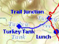
As already noted this hike was intended to roughly duplicate a 2009 Skyliner hike on what our leader called Twin Peaks Trail. However, in addition to starting at Verde Valley School Road for today's hike rather than at Turkey Creek Trailhead where we started in 2009, we made two other deviations from the GPS track. First, as we approached the base of the easternmost of the twin peaks, we had left the trail in 2009 to pass higher along the slope of that peak (below left, blue track) and then descended to rejoin the trail in the pass that lies east of both peaks for the trip down the slope to rejoin Turkey Creek Trail. The trail crossed the creek, which was dry as usual, twice on the way down. We stopped for lunch at the wide, bare slab of stone that formed the creekbed at the second crossing. From there, it was just another 0.2 miles to the Turkey Creek Trail junction and our second deviation from my six year-old GPS track. In 2009 we had turned west on the trail and hiked 0.3 miles to Turkey Creek Tank (below right, blue track) and returned before continuing on our loop hike.

Deviation at Twin Peaks 
Deviation at Turkey Tank
We were now more interested in visiting Turkey Trail Sinkhole. For me this was the last of seven Sedona area sinkholes to be visited, the other six having already been included in various Skyliner hikes. The seven Sedona area sinkholes are all listed below in clockwise order:
  1. Devils Kitchen Sinkhole
  2. Mitten Ridge Sinkhole
  3. Devils Dining Room Sinkhole
  4. Turkey Trail Sinkhole (5th largest of the seven)
  5. Nolan Draw Sinkhole
  6. Red Canyon Sinkhole (largest of the seven)
  7. 4543 Sinkhole (smallest of the seven)
These are all described in detail by Paul A. Lindberg in Sedona Sinkholes and Groundwater Flow: The Geologic History of Their Evolution, Coconino and Yavapai Counties, Arizona, published in 2010 by the Arizona Geological Survey as Contributed Report CR-10-C1.

This sinkhole has a relatively small opening as shown in the below photograph.

Small, 5 feet by 10 feet, opening to Turkey Trail Sinkhole
According to Lindberg, the small opening shown above widens below to an opening of 25 feet by 85 feet. He reports that the depth from the rim to the ”bottom of collapse breccia” is 75 feet.

There were remnants of an old fence around the perimeter of the sinkhole, apparently left over from when the area was pastured. The below group photograph was taken from the northeast side of the sinkhole, looking across it to hikers standing on the southwest side. There was an intact section of fence behind the photographer but, as can be seen, no fence remained on the other side of the opening where the hikers are lined up.

Left to right: (front row): Dolly Yapp, George Everman and Daisy Williams; (back row): Jim Manning, Beverly Sass, David Beach, Terry Johnson, Anita Jackson, Roger Fenske, Lila Wright and Dave Healey - the author and one other hiker are not shown
This loop hike was 5.5 miles in length. The highest elevation was 4331 feet and the total ascent was 1160 feet. On the below map, our GPS Track is shown in red. The two short blue sections of track highlight the deviations between today's hike and the 2009 GPS track..


1 http://www.azgs.az.gov/publications_online/contributed_reports/cr10c.pdf