Twelve Skyliners
gathered at 0800 on 19 March 2016 for the last winter hike of the
year. Tomorrow would be the first day of spring, the earliest since
1896. The Vernal Equinox marking the event actually would occur
today at 2040, making tomorrow the first full day of the spring
season.
Leaving
Cottonwood, we drove 4.7 miles east on SR 260 and turned right on
Forest Road 147 (This forest road may not be marked but the turnoff
is almost directly across the highway from Thousand Trails Road which
is marked.) Shortly after turning onto FR 147, an old road leads off
to the left. It is only a stub, being a remainder of Old SR 279
(since replaced by SR 260). FR 147 then turns to the right and ends
at a fork, the left fork being FR 361 and the right being FR 360. We
chose the right fork, heading northwest, because it crosses Wilbur
Canyon and then turns up the north rim of the canyon, forming the
first leg of our loop hike.
 Since
passing the turnoff that I said was a stub of Old SR 279 we had
actually been following the course of that old road, at first for a
short distance on FR 147, then after the fork, on FR 360. We now
continued across Wilbur Canyon on FR 360/Old SR 279 and parked at a
fork in the road where FR 360 turns to run in the southwest
direction along the rim of the canyon. The old SR 279 Road (see
magenta track at right) continues straight ahead, now
becoming FR 9604D, a designation it keeps as it continues across
Black Canyon and on to a junction with FR 359 (Ogden Ranch Road),
which it crosses and continues as Old SR 279, now a paved road, until
it reaches East Arrowhead Lane in Verde Village 7. There it connects
with Camino Real which runs on into Cottonwood to end at Main Street
(SR 89A) just 0.2 miles from the intersection of SR 89A and SR 260.
Since
passing the turnoff that I said was a stub of Old SR 279 we had
actually been following the course of that old road, at first for a
short distance on FR 147, then after the fork, on FR 360. We now
continued across Wilbur Canyon on FR 360/Old SR 279 and parked at a
fork in the road where FR 360 turns to run in the southwest
direction along the rim of the canyon. The old SR 279 Road (see
magenta track at right) continues straight ahead, now
becoming FR 9604D, a designation it keeps as it continues across
Black Canyon and on to a junction with FR 359 (Ogden Ranch Road),
which it crosses and continues as Old SR 279, now a paved road, until
it reaches East Arrowhead Lane in Verde Village 7. There it connects
with Camino Real which runs on into Cottonwood to end at Main Street
(SR 89A) just 0.2 miles from the intersection of SR 89A and SR 260.
Leaving
our cars parked at the junction of FR 360 with FR 9604D, we donned
our packs and headed up the Wilbur Canyon rim on FR 360. Although we
would ascend about 750 feet as we followed FR 360 toward the Black
Hills, we had 3.5 miles in which to do it and the slope was gradual.
We scarcely noted that we were climbing.
 |
The steepest and roughest section of FR 360 running up the Wilbur Canyon rim
|
Although
the day had started out just a bit chilly, the sun was now bearing
down and we were all in shirtsleeves. The warm sun and the fact that
spring was upon us meant that we should be seeing wild flowers, so we
started looking for them. Unfortunately, except for patches of
blackfoot daisies, flowers were few. I did find one particularly
attractive clump of daisies (below
left) and a somewhat faded verbena
(below right)
as made our way up the road.
 |
| Blackfoot daisy Verbena |
 |
| Junction of FR 360 (left fork) and FR 9710H (right fork) |
The left fork in the
road shown in the above photograph is FR 360 which continues for
another 0.8 miles, crossing Wilbur Canyon and ending at a place
called Goat Camp Springs. Wilbur Canyon, itself continues
west-southwest for about another mile and then turns to run south to
its origin below Cherry Peak in the Black Hills.

Before
continuing our hike, we stopped in a shady spot at the junction of
the forest roads for a short rest, a snack and to pose for the group
photograph shown here (below). The
author, acting as photographer, does not appear in the group
photograph but is shown separately (left),
lounging under a tree.
 |
| Left to right: Dolly Yapp, Floyd Gardner, Jim McGinnis, Ellen McGinnis, Betty Wolters,Karl Sink, Joanne Hennings, Collene Maktenieks, Jim Gibson, Daisy Williams and Jim Manning |
From
the junction, FR 9710H led us 0.3 miles west southwest before turning
northwest by north for 0.1 mile to the junction with FR 9604C. At
this point FR 9710H becomes ATV Trail 514 (note, however, that the
Prescott National Forest Motor Vehicle Usage Map
shows FR 9710H extending for another 100 yards and also shows ATV
Trail 514 as ATV Trail 509).
In
another deviation from the Motor Vehicle Usage Map,
which shows our intended return path, FR 9604C, as open to motorized
vehicle traffic with camping permitted all along the way, the road is
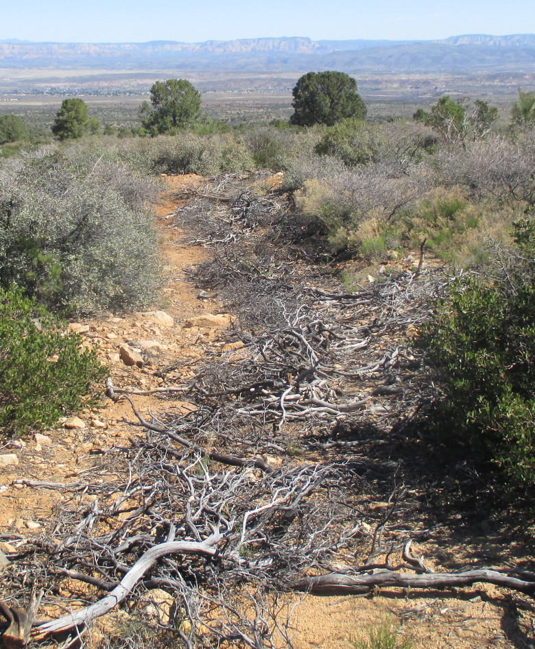
now blocked off and closed to all motorized vehicles. At the
beginning of the closed section of road, the roadbed is filled with
brush cut from manzanita shrubs, as shown in the photograph (left).
This closure didn't, at
first, appear to be a serious problem for us as we were on foot, not
using motorized vehicles. We just continued on our way, following
the old roadbed as closely as possible. Hiking did become a bit more
difficult as the manzanita was supplanted by catclaw plants growing
closely alongside the old road. These plants are vicious, seemingly
reaching out to snare the unwary passerby. Once caught by the
plant's grasping, clawlike hooks, any attempt to pull loose is met by
even deeper penetration. The victim's only recourse is to stop and
patiently release the claws one by one. Even then it is not uncommon
to find that, while working to free an arm or leg, another part of
ones anatomy has been ensnared.
As we descended the
mountain, plant growth changed and thinned. We left the manzanitas
behind and were surrounded by scrub oak, ceanothus and other desert
plants. The larger junipers appeared to have been removed some time
ago, probably in an attempt to encourage the growth of grass for
grazing. The plants that had been cut and piled on the old roadbed
changed to reflect what was available and also became more sparse.
Our view stretched
across the Verde Valley to the Mogollon Rim in the distance. Below
is shown a view looking north across the upper valley toward Sycamore
Canyon with a slice of the Black Hills to the left and a bit of the
Mogollon Rim to the right
 |
| View looking across upper Verde Valley toward Sycamore Canyon |
We
also saw a few more flowers. Shown below are a solitary desert
marigold (left)
and a desert hyacinth (right)
 |
| Desert marigold Desert hyacinth |
 |
| Alternating pits and humps used closing a section of FR 9604C to motorized traffic |
Climbing
in and out of the pits and over the humps made hiking a bit tedious;
on the other hand vegetation had now thinned out so that we could
just walk alongside the old road a large part of the time.
When we reached Goddard
Tank Two the road closure ended and the remaining 1.8 miles of FR
9604C back to FR 9604D, being used to access the tank, was now in
good condition.
Just
one mile below Goddard Tank Two, where an overhead powerline crosses
the road we found the other (unmarked) end of ATV Trail 514 (or 509).
We could have taken that trail from the top and avoided the closed
section of FR 9604C. However, it would have been 2.1 miles farther
than the way we came.
 When
we arrived at the end of FR 9604C where it joins FR 9604D (old SR
279) we were just 0.3 miles from our cars and could see them clearly
on the far bank of the wash we had looped around on this hike. As a
reminder of its past import-ance as a major thorough-fare we noted a
small section of pavement (right)
still existent on the Old SR 279 roadbed.
When
we arrived at the end of FR 9604C where it joins FR 9604D (old SR
279) we were just 0.3 miles from our cars and could see them clearly
on the far bank of the wash we had looped around on this hike. As a
reminder of its past import-ance as a major thorough-fare we noted a
small section of pavement (right)
still existent on the Old SR 279 roadbed.
We
were soon back at our vehicles and ready to head home. I had driven
my pickup because I intended to return home by way of Old SR 279. By
that route it was only about 3.8 miles to my home in Verde Village 7.
The
total hike distance was 8.2 miles, the highest elevation was 4209
feet and the total ascent was 919 feet.
Our
GPS track is shown in red on the included map (below).

No comments:
Post a Comment