Driving Familiar Roads and Invoking the Past
Day 1 (23 September 2016)
Not everyone understands the urge to travel just for the sake of traveling, rather than to see specific sights. For that reason when I decided to retrace some of the old routes I have traveled in the past, I explained it by saying that I intended to visit some of the places where my ancestors lived in East Tennessee and also see the fall colors.
The idea of viewing fall colors was actually very attractive but I was a little early and the season in East Tennessee had been too dry for really great colors. As for following up on my ancestors, I had a general idea as to where some of them were buried and hoped to find gravestones. Unfortunately, most of the gravestones had deteriorated over the years and few names were still discernible for the period of interest. However, I enjoyed very much driving through the areas where they lived.
Retracing previously traveled routes was a very rewarding experience because I was now traveling with no specific schedule and was thus able to pause and investigate anything that interested me along the way. I made motel reservations one day ahead of time, always staying at locations where I could cancel at the last minute in case I wanted to go a different route.
My first day's travel would be along the Mogollon Rim, primarily along AZ Hwy 260. This was a route that I had traveled numerous times while working as a loss control consultant for CNA Insurance Company. It was an alternate route from Cottonwood, AZ to Albuquerque, NM where I did a lot of work. I also traveled this way to service the sawmill, ski resort and casino on the White River Apache Reservation. AZ 260 starts in Cottonwood at an elevation of about 3400 feet, passes through Camp Verde, rises to the Mogollon Rim and connects with AZ 87 at an elevation of about 7000 feet.
It was 0900 by the time I had loaded all my gear and was ready to start my trip on 23 September 2016. Rosemary used my camera to take the following photograph as I was preparing to leave.
 |
Loaded and ready to go
|
I drove through Camp Verde and started the climb to the Rim, passing by the looming formation of Thirteenmile Rock Butte and briefly stopping at Apron Tank where the old General Crook Wagon Trail passes close to the highway. According to the map, Apron Tank extends to both sides of the highway. The part shown here (below left) lies on the south side of the road. A pedestrian/equestrian gate allowing access along the old Crook Trail on the north side of the highway is also shown (below right).
 |
| Apron Tank Access gate on Crook Trail |
Continuing on past Apron Tank, I climbed another 1000 feet and reached the Mogollon Rim at the AZ 260/AZ 87 junction just about an hour after leaving home.
From the junction of the two highways, AZ 260 runs with AZ 87 for about 28.7 miles to Payson. Following convention, the mileposts along this stretch of road continue with the AZ 87, the north-south highway, numbering scheme. What is interesting to note is that the last mile marker on AZ 260 before the junction is number 251 (posted just 0.9 miles before the junction) and that the next AZ 260 mile marker is 260 (posted just 0.1 mile after the Payson junction of the two roads). Needless to say, this makes it difficult to measure travel distance along AZ 260 by reference to milepost markers. When traveling this way in the past in the area, I was confused several times by the difference between my recorded miles and what was indicated by the mile markers.
Although I have referred to this day's drive as being along the Mogollon Rim, much of it is actually below the rim. Just about four miles after reaching the rim the road dips sharply down to the tourist town of Strawberry, tucked close under the rim but about 1200 feet lower. From there the road continues southeast through Pine, another small tourist town, to Payson. Payson is located about seven miles south of and around 2000 below the rim. There the two highways, AZ 260 and AZ 87 separate, with AZ 260 heading northwest back toward the rim and then following closely below it before ascending at the Mogollon Rim Visitors Center, while AZ 87 heads south toward the Phoenix area.
From the visitor center, I continued east atop the rim for another 45 miles, passing through the small communities of Heber-Overgaard and Clay Springs to Pinedale. There, I made a short detour south on Pinedale Road to see the Pinedale Covered Bridge. A Wikipedia entry proclaims this to be the “the only covered bridge in Arizona.” 1 This claim, however is disputed by another online source 2 which lists at least a dozen such bridges. The bridge at Pinedale, shown below, is located on Pinedale Road about 0.5 miles south of AZ 260.
 |
Covered bridge located on Pinedale Road, Pinedale, AZ
|
I left the covered bridge behind and continued on to Show Low, AZ where I had booked a room for the night.
After checking into my motel and unpacking my computer to record the days events, I discovered that I had failed to pack my infrared mouse. I could, of course, have used the built-in mouse on my laptop; however, I find that extremely awkward and there was a Walmart nearby, so I headed out to purchase a replacement mouse. As I drove down the main street, I noted a large number of people lined up along the road in lawn chairs as though for a parade. Being fairly sure that that was not a welcoming event for me, I asked the clerk at Walmart what was going on. She had no idea; however, another shopper informed me that they were all lined up for an antique car show. Apparently, the car show was to start with a drive down Main Street just as I was returning to my motel. I made a very leisurely return trip surrounded by a sea of vintage automobiles. If anyone noted that my 2006 Ford Ranger was not exactly an antique, they were kind enough not to say anything.
After returning to the motel I downloaded all the pictures I had taken that day from my camera to a folder on my laptop named with the day's date. I then copied the GPS file from the unit mounted in my truck. I then copied that folder to a separate USB drive. I repeated this procedure each day for the entire trip.
The main road through Show Low carries US 60, AZ 77 and AZ 260 traffic. My travel on AZ 260 ended at the junction with US 60 and I would follow that US highway on to Socorro, NM. Arizona 260, on the other hand, turns south and continues along the Mogollon Rim to Indian Pine (not actually a town; it has a Pinetop mailing address) where the White Mountain Apache Tribe's Hon-Dah Casino and Conference Center is located. From there AZ 73 runs south through the reservation to White River and Fort Apache and then turns west to connect with US 60 near Carrizo. While still working, I had traveled this route numerous times while visiting the Fort Apache Timber Company at White River.
But back to AZ 260 at the Hon-Dah Casino. From its junction with AZ 73 it continues east along the rim through McNary and Eagar to end at a junction with US 191 a little over two miles east of Eagar (southeast of Springerville). I used this section of highway during my travels to service tribal facilities; the tribe's Sunrise Park Resort, accessed by way of AZ 273 about half way between McNary and Eagar.
The trip from Cottonwood to Show Low is shown on the included map (see below).
Driving Familiar Roads and Invoking the Past
Day 2 (24 September 2016)
But enough about roads traveled in the past. The next morning I left the Mogollon Rim behind and traveled east across the relatively flat Colorado Plateau on US 60 toward Springerville, about 48 miles away. From Springerville it is still another 14 miles to the New Mexico border. The highway runs through open rangeland with scattered ranch buildings. The surrounding terrain consisted of low rolling hills, the crest of each hill providing another far-reaching view of the open country that lay ahead.
My first planned stop in New Mexico was at Pie Town, a small community located some 20 miles from the Arizona border, just as the road starts its descent from the eastern edge of the Colorado Plateau to the Plains of San Agustin. I stopped for a piece of pie at the store shown below, one of at least two such establishments in the small town. I chose a small cherry pie, my favorite, and had the waitress prepare half of it to go.
 |
Store in Pie Town, NM
|
The road crosses the continental divide at Pie Town, continues about another 10 miles through an area broken by low but well-defined mountains, to West Pass. Crossing through the pass, it enters White House Canyon, a long open canyon that slopes down about 700 feet in a ten-mile stretch ending at the small community of Datil, perched at the edge of Cibola National Forest. The photograph below shows the view ahead as the road makes its way down the canyon above Datil.
 |
US Highway 60 in White House Canyon, Cibola National Forest, New Mexico
|
From below Datil, the Plains of San Agustin on which the National Radio Astronomy Observatory's Very Large Array Radio Telescope is located are laid out to the east.
 |
The Plains of San Agustin from just east of Datil
|
The Very Large Array Radio Telescope is located on the San Agustin Plains between the community of Datil and the town of Magdalena. The partial overview of the array shown below was compiled from a series of photographs taken from near the visitors center.
The antenna are mounted on rails in a Y configuration, as can be seen from the below photograph from Wikimedia Commons; the legs can be extended by moving them closer together or farther apart along the rails from the center or hub.
 |
Partial overview of the Very Large Array Radio Telescope
|
 |
VLA Array photograph from Wikimedia Commons 3
|
Special transporters are used to reconfigure the array by moving to different positions, basically closer to or farther from the hub of the array. The below photograph is available on Wikimedia Commons.
 |
VLA Transporter from Wikimedia Commons 4
|
The 27 dish antennas of the VLA Radio Telescope collect invisible radio waves emitted by objects just as a camera collects visible light waves. These radio waves are processed into digital images. The signals collected by the individual antennas are processed and sent to a central supercomputer so that the antennas work together, acting as one “impossibly-large antenna” the size of entire VLA array of 27 antennas. Moving the antennas in and out along the tracks of the Y zooms the array, producing images with varying degrees of detail. 5
The photographs below, taken at the visitor center, provide additional specifications, electronics, mechanical & rail system details.
 |
Antenna specifications
|
 |
Antenna (electronics)
|
 |
Mechanical details
|
 |
The rail system
|
A virtual tour of the facility is available online 6.
I had driven past the observatory a number of times while working in New Mexico and had even paused alongside the road to view the antennas; however, I was usually on my way to an appointment somewhere else in the state and this was the first time that I had stopped at the visitor center. It was well worth the time.
As I left the VLA behind and continued east on US 60, my mind drifted to a 1977 trip down this road with my two daughters, Julia and Diana and a friend of theirs, Janine Holmes. Diana was then 7 years old, Julia was 8 and Janine was 9. We were stopping in Magdalena for a visit with a distant relative. Aunt Annabelle's brother, Albert Roby, had married my mother's first cousin, Cecil Beatrice Brown, so the relationship was indeed rather distant. But I had spent a lot of time with Cecil and Albert Roby while homeported in California. The following is quoted from my book A Little Work and some Luck, page 100, published in 2011. 7
Meanwhile, ashore in the Long Beach area, my mother’s first cousin, Cecil Beatrice (Mamaw) Roby and her husband Albert (Papaw) lived in a nearby suburb and I started to spend a lot of time with them. They were dedicated churchgoers and I usually attended a small Baptist Church with them, eventually becoming a member of the church. I really couldn’t bring myself to fully accept all of the church teachings. However, I really liked the people in the congregation, thought that they were making a positive difference in the community with their youth programs, and what I didn’t totally agree with, I could just be quiet about. There was always some group activity, for instance all day outings in the nearby mountains, scheduled for any given weekend, if not by the Robys then by a church group.
I had become acquainted with Aunt Annabelle through my close relationship with Mamaw and Papaw Roby and it would have been unthinkable to pass through Magdalena without stopping to see her. In any case, she lived alone and always welcomed company. Although Aunt Annabelle, already elderly in 1977 was now long dead, I decided to stop and photograph her old house. I found it, as shown below, still standing, little-changed from its condition in 1977.
 |
Aunt Annabelle's house in Magdalena, New Mexico
|
I didn't linger in Magdalena, just snapped my photograph of the old house and continued on my way. The town itself is located just at the northern end of the Magdalena Mountains and the road to Socorro led through a gap between the mountain range and a smaller formation labeled Granite Mountain, which appears to be an outcropping of the Magdalena range. However, it might instead be associated with the Bear Mountain range located to the north. In any case the road led to Socorro and that is where I intended to bed down for the night.
Arriving in Socorro about the middle of the afternoon, I checked into my motel, downloaded the photographs I had taken that day and then went is search of a place to eat dinner. There were several likely restaurants nearby, but I noted a Domino's Pizza restaurant nearby and decided to give it a try. I bought a vegetarian pizza to go and enjoyed a nice dinner in my room.
The trip from Show Low, Arizona to Socorro, New Mexico is shown on the included map (see below).
Driving Familiar Roads and Invoking the Past
Day 3 (25 September 2016)
The next morning I left the motel, drove about 10 miles south on Interstate 25, exited at San Antonio and crossed the Rio Grande going east on US 380. I drove through a swath of irrigated fields in the Rio Grande valley, continued across miles of wide-open grazing land where I paused to photograph the view ahead and followed the road up Hale Canyon in the foothills north of the Oscura Mountains. From there the road ran across another plain with an elevation of about 6000 feet where it intersected with and then followed the northern boundary of White Sands Missile Range to the top of Chupadera Mesa at Taylor Canyon, (Signs are posted warning that the road may be closed for missile tests) which it then followed down the other side to another plain north of Tularosa Valley. Crossing this plain the road climbed an outlying ridge and, as shown below, from there I could see across the Malpais with its Valley of Fires Recreation Area to the Sacramento Mountains beyond Carrizozo.
 |
Looking across the Malpais to the Sacramento Mountains beyond Carrizozo
|
At the bottom of the ridge, the road enters the Malpais (rough country underlain by dark especially basaltic lava 8). Roadside parking is available at the western edge of the lava field. The Valley of Fires Recreational Area (a designated U.S. Fee Area) is located at the eastern edge of the field.
I stopped first at the roadside parking area and climbed into the field for a closer look. I had stopped at the El Malpais National Monument near Grants, New Mexico, some 150 miles northeast of this location. However, I had never stopped before at the Carrizozo Malpais. Shown below are a general view of the lava rocks (below left) and a close up photograph of a layered, distorted rock (below right).
 |
General view of lava rocks Close-up of layered, distorted rock
|
I left the roadside parking area, and drove to the eastern edge of the field and checked out the Valley of Fires Recreational Area. I got there on a “Fee-Free” day, perhaps because it was Sunday, so I drove in and looked around. Day use fees normally range from $3 for a vehicle with one occupant to $10 for 10 or more. Developed campsites are $12 ($18 with electricity). Toilet facilities and a gift shop are provided. The lava field is shown as seen from the recreation area.
 |
The Carrizozo Malpais as seen from the Valley of Fires Recreation Center
|
The below NASA photograph 9 shows the Carrizozo as seen from space
 |
NASA image created by Jesse Allen, using Landsat data provided by the
United States Geological Survey. Caption by Michon Scott.
|
The same NASA site also provided the below information:
In south-central New Mexico, some 25 kilometers (15 miles) north of the brilliant white gypsum deposit that includes White Sands National Monument, a charcoal-brown scar undulates across the arid landscape. The scar is the Carrizozo Malpais, a massive lava flow left over from volcanic activity that occurred several thousand years ago. Stretching roughly 75 kilometers (47 miles), Carrizozo is one of Earth’s longest known lava flows from the Holocene Epoch (the geologic time span since the end of the Pleistocene Ice Age).
The enhanced Thematic Mapper on NASA’s Landsat 7 satellite captured this photo-like image of Carrizozo Malpais on May 18, 2003. The flow varies in width from 1 kilometer (0.6 miles) along its slender neck to 5 kilometers (3 miles) at either end. Within its curving borders, the Carrizozo lava flow has a uniform dark color, thanks to its basalt content. Basalt tends to flow easily, and this lava flow is described as a pahoehoe flow—advancing through lobes or toes that separate from a cooled crust. The high point on Carrizozo is Little Black Peak. This is a cinder cone—a simple type of volcano made from congealed droplets and blobs of lava that erupted from a single vent.
The Carrizozo lava flow originated from a shield volcano with a low, broad profile resembling an ancient warrior shield. The lava’s composition enabled it to flow easily down the Tularosa Basin, an area of depressed rock in southern New Mexico. Geologists suspect that this massive lava flow occurred in a single episode that lasted 20 to 30 years, and date the surface of Carrizozo at roughly 5,200 years old. An older, less conspicuous lava flow emanated from Broken Back Crater to the north.
Near the lava flow’s northeastern end is the town of Carrizozo. Both southeast and northwest of the lava flow, the landscape appears dark, but this result not from volcanic rocks but from vegetation-lined hills 10.
My curiosity about the Malpais satisfied, I continued east on US 380. Leaving the Malpais and the town of Carrizozo the road passed south of the Vera Cruz Mountains, followed Indian Canyon to a high point called Indian Divide at an elevation of about 7000 feet, descended on the other side descended along South Salado Creek to Oso Creek and followed it on to Capitan.
Capitan with a 2010 population of 1489 is located in Lincoln County, New Mexico in a pass between the Capitan Mountains to the north and the Sacramento Mountains to the south. It is the site of the Smokey Bear Historical Park which contains Smokey's grave, and is located on the Billy the Kid Trail, an 84.3-mile scenic drive that will take you through the country where Billy lived.

Smoky the Bear (
right) originated in 1945 when the Forest Service produced it's first fire prevention poster bearing the picture of a bear. In 1950 a badly-burned black bear cub was rescued from a forest fire in the Capitan Mountains. Named Smokey, he became the real-life version of Smokey Bear and lived in the National Zoo for 26 years until his death in 1976.
The historical park is a small, compact area located in the middle of town. However, in addition to Smokey's gravesite, shown below, it has a surprising variety of neatly-labeled trees, grasses and shrubs.
 |
Smokey The Bear gravesite
|
I have never been too enthralled with the legend of Billy the Kid. As an historical figure, he appears to have been no more than a ne'er-do-well killer whose reputation was burnished by reporters. But the scenic drive trail (left) named after him deserves consideration on its own merits. If one starts at Capitan, the trail leads east along US 380 to Hondo, follows US 70 west to Ruidoso Downs and then NM 49 north back to Capitan. This loop (red track) constitutes 68.2 miles of the trail. To drive the remaining segment, go east on US 380 for about 4.3 miles and then turn south onto NM 220. This is a 16.1 mile segment (copper track) that runs through Fort Stanton and then connects with NM 48 north of Ruidoso Downs. I have driven all of the Billy The Kid Trail except the 16.1 miles through Fort Stanton in the past while working in the area.
I paused on the way out of Capitan to snap a photograph of a historical marker (below left) which provides a brief history of the town. I then drove another 12 miles or so and photographed another historical marker (below right) posted in the town of Lincoln.
 |
Capitan historical marker Lincoln historical marker
|

The Lincoln County War appears to have been a battle ranchers and merchants for control of the county. The merchants, Murphy and Dolan, owners of a mercantile and banking operation supported by a corrupt organization that extended all the way to the territorial capital, controlled the sheriff and court system. Tunstall, an English immigrant set up a ranching operation in 1876, allied himself with rancher McSween, and set up a mercantile store to compete with Murphy and Dolan. Both sides hired gunmen, including then eighteen-year-old William Bonney, aka Billy the Kid (
right 11), who worked for Tunstall. Actual hostilities started in 1878 when sheriff's deputies shot and killed (murdered?) Tunstall. In reaction to Tunstall's death, Justice of the Peace John Wilson swore in employees of Tunstall as special constables. This group, calling themselves the Regulators, went after the men implicated in Tunstall's death. Thus, two legally deputized posses rode at large in Lincoln at war with each other. The Army intervened and defeated the Regulators in July 1878. The regulators quickly left town with Billy the Kid relocating to Fort Sumner, New Mexico where he formed his own gang of outlaws. He was killed by Sheriff Pat Garrett on 14 July 1881
12.
It was only another 60 miles from Lincoln to Roswell and I arrived at my motel in the early afternoon. I quickly checked in and then left for a quick visit to the UFO Museum.
 |
Entrance to the UFO Museum in Roswell, New Mexico
|
The UFO Museum contains everything from the wildest fantasies to hard facts. Shown below are a poster purporting to capture the public's initial reaction to the crash of in 1947 (below left) and an otherworldly rendition of aliens disembarking from a spaceship (below right).
 |
Flying saucer poster Depiction of alien landing
|
In 1947 the United States announced that it had recovered some flying discs. The newspapers reported this as the capture of flying saucers at Roswell, new Mexico. The following day the government issued a correction, saying that what they had recovered was a crashed weather balloon. In 1995 this was corrected to reveal that what really crashed was a device we were using to spy on the Soviet Union, a large balloon with microphone discs suspended from it designed to detect nuclear explosions. This information is all very coherently incorporated into a physics lecture presented by Professor Richard Muller of the University of California, Berkeley. The lecture is available online for those who might be interested. 13
The drive from Socorro, New Mexico to Roswell, New Mexico is shown on the included map (below).
Driving Familiar Roads and Invoking the Past
Day 4 (26 September 2016)
An interim goal for this trip was to visit the Wiseman Cemetery, located near Salem in north central Arkansas. Traveling at my rather leisurely pace, that would be another three days travel. I planned to stop overnight at Wichita Falls, Texas and then at Van Buren, Arkansas on the way. The third night would be spent at Salem.

Today's drive from Roswell to Wichita Falls would be 388 miles, a relatively long drive, and I had no specific stops scheduled. I drove east on US 380 across the Staked Plains
14 (Llano Estacado), passing through Caprock, New Mexico and Plains, Texas and then on through the small Texas towns of Tokio, Brownfield and Tahoka before making a barely noticeable 3-mile, 300-foot descent down the Caprock Escarpment (
left) to the cotton-growing Rolling Plains Region of Texas at Post.
Leaving Post, I found myself traveling across vast fields of cotton, stretching to the horizon in all directions.
 |
Cotton fields in the low plains of Texas
|
Most of the day-long drive was across this cotton-growing region, broken by some hilly country with what appeared to be small cattle-growing operations around the two Salt Fork crossings of the Brazos River. Closer to Wichita Falls I saw some stubble-filled fields from which grain, wheat I think, had been harvested.
While driving across this stretch of country dotted by small towns, some of which didn't even have service stations, I very nearly ran out of gas. I never got low enough for the alarm to sound, but I had begun to worry at one point. After that I changed my rule from “look for a service station at a quarter-tank” to “look for a service station at a half-tank.”

At Haskell, a medium-sized Texas town, about 300 miles from Roswell, I waited for about 45 minutes while a Fort Worth and Denver Train (
right) jockeyed back and forth at a railroad crossing. Other than almost running out of gas, that was the most exciting part of the day.
I arrived at my motel at around 1530, checked my e-mail, saved my day's GPS track and the two photographs taken during the day to my laptop and a backup drive, showered and went to at a nearby Johnny Carino's restaurant. Carino's is one of my favorite restaurants and the meal was ample enough that I had leftovers for lunch the next day. I would place these in a small cooler/warmer that plugs into my cigarette lighter outlet and enjoy a nice warm picnic lunch somewhere in Oklahoma the next day.
The drive from Roswell, New Mexico to Wichita Falls, Texas is shown on the included map (below).
Driving Familiar Roads and Invoking the Past
Day 5 (27 September 2016)
I checked out and left Wichita Falls at 0830 under overcast skies. It really did not look like it would rain; it was just one of those days that hesitated to make a full appearance, keeping the sun hidden as long as possible.
Leaving Wichita Falls behind, I drove northeast on TX 79, driving the guide in my Garmin Nuvi GPS crazy. The device was convinced that the best route to Van Buren, Arkansas, my next stop, was by way of Oklahoma City. I, on the other hand, was determined to take secondary roads that would take me through the foothills of the Ouachita Mountains, completely bypassing the sprawling, congested mess of the Oklahoma City metropolitan area. The GPS took verbal exception every time I made what it considered to be a wrong road. I had long since changed its computerized voice from Jill to Jack, that is from female to male gender. Somehow, Jill just seemed to become a bit hysterical when I turned onto a road she had not recommended. Jack, on the other hand, although still sounding quite disapproving of my unwise navigational decisions, did seem to take them in stride, just calmly directing me to make corrections.

Texas Highway 79, the road I followed from Wichita Falls, crossed the Red River (
right 15) into Oklahoma after about 35 miles; it then continued with the same number for about four miles into Oklahoma to connect with US 70.
I followed US 70 east for about 55 miles to Ardmore where it turned to run southeast. From Ardmore I continued east on OK 199, which ran jointly with US 177 part of the way, for about 23 miles. I then turned north on OK 1 and crossed the Washita River and continued north and east on a series of state and county roads to Atoka where I connected with US 69, a route that would take me all the way to I-40, about 70 miles west of Van Buren, Arkansas where I planned to stay for the night.
About 15 miles north of Atoka, the highway runs through Limestone Gap, a gap in the 70-mile Limestone Ridge, a long, narrow ridge that runs from near Le Flore at the north edge of the Ouachita Mountains and curves, like a languid, drooping finger, around the northeast of the range to end at the Atoka Reservoir north of Stringtown.
It was a few minutes after noon when I crossed the ridge and, remembering the goodies I had saved from yesterdays evening meal, I quickly started looking for a stopping place and, about ten minutes later, found a nice shady side road (below left). There I laid out my leftover bread, olive oil and minestrone soup (below right).
 |
A shady side road A most satisfying lunch
|
I lingered for awhile after lunch, sipping from the thermos of tea I had made at the motel this morning. I was even considering taking a short nap when, with a mighty, clattering roar a train came rushing past on railroad tracks hidden from view by the trees and underbrush lining the road. I think the train must have taken the better part of ten minutes to pass and by then I was wide awake.
I still had about 136 miles to drive and, even if I arrived at Van Buren early, they would likely have a room ready, so I decided to press on. I was stopping at the Holiday Inn Express where Rosemary and I had had an unsatisfactory experience a few weeks previously. Then the fully-booked facility was manned by a single staff member who simply stuck a sign on the counter when he left the front desk for any reason. That evening I discovered that one of the two water heaters had been turned off to save energy. Nothing indicated this and I used the one with cold water for my hot tea, necessitating a trip back to my room for fresh tea leaves. Then the next morning we had to wait for 30 minutes for the single luggage cart to become available.
I had sent a rather blistering report to corporate indicating how poorly-managed the facility was and was curious to see whether any changes had been made. To my amazement, I now found a fully-staffed motel with four luggage carts neatly lined and ready for use. And, when I made my evening tea both pots had hot water. Sometimes complaints do work.
Another reason for staying at this motel was to look again at the tackiest, but most intricately-crafted church sign I have ever seen. Shown below, it stands in front of a nearby Pentecostal Church.
 |
Surely the gaudiest church sign ever created
|
The drive from Wichita Falls, Texas to Van Buren, Arkansas is shown on the included map (below).
Driving Familiar Roads and Invoking the Past
Day 6 (28 September 2016)
Today I would visit Wiseman Cemetery in north central Arkansas where my paternal grandparents are buried. I had located their graves online at Arkansas Gravestones.org 16 and wished to see the actual site. To get there, I could drive north on I-49 to Fayetteville, Arkansas and then take US 412 east to Salem, Arkansas, where I planned to spend the night, before continuing on for another 16 miles to the cemetery. However, after some thought, I decided to drive east on I-40 to Morrilton and then go north on State Roads directly to Wiseman Cemetery before continuing on to my motel in Salem.
I left Van Buren around 0830 and followed I-40 for 124 miles to Morrilton before turning north to follow state highways AR 9, AR 5, AR 56 AR 354 to Wiseman. I could have followed AR 9 all the way, but chose to follow the guidance provided by my GPS. As it were, at about 85 miles from Morrilton, having traversed sections of AR 9 and AR 56, I was back on AR 9 when I reached the junction with AR 354, about 18 miles from the cemetery. My route had taken me through the Boston Mountain foothills, a part of the Ozark Mountain Range, and down to the Salem Plateau on the other side. The Wiseman Cemetery lies about 20 miles at a bearing of 253 degrees true from Hardy, Arkansas (upper right on below map)
 |
Topo relief map – southern end of the Ozarks 17
|

The road had been good and the scenery, woods and fields dotted with, mostly small, well-kept homes, was fantastic. As I traveled farther north into the mountains the wooded areas became more extensive and the homes a little less expansive. In the late morning, I found myself high in the Boston Mountains and sought a side road warm spot on a sunny side road (
right) for a rest stop.

When I had descended from the mountains and crossed the White River at Calico, the wooded areas decreased and the farms became more substantial. Finally arriving at 354 Wiseman, I found that it to basically be just a very small community, anchored by a post office. The Wiseman Cemetery is about a mile away as shown on the map (
left).

My GPS track took me directly to the cemetery and, finding the gates open (
right), I drove onto the grounds and paused for a leisurely lunch before investigating any of the graves. After all the dead were used to waiting.
After lunch I started examining graves to see whether I could find those of my grandparents. Unfortunately, the engravings are badly eroded and I was unable to identify them. I could have likely done so by cleaning the most likely ones and using some kind of solution to make the markings stand out. However, that would have involved more time and effort than I was prepared to devote to the project. I would instead seek permission to use the photographs of their gravestones that I had already found online. Permission was granted and the gravestones for Grandfather James Buchanan Price (below left) and Grandmother Eliza Jane Price (below right) are shown here.
 |
Grandfather James Buchanan Price 18 Grandmother Eliza Jane Price 19
|
Sometime during the day I received a text message, followed by a telephone call from my niece, Melissa, telling me that her father, my brother Clarence, undergoing chemotherapy for lung cancer, had experienced an allergic reaction to a platelet transfusion. This was possibly complicated by a heart condition and he was in the hospital's Intensive Care Unit undergoing testing. They would know nothing until tomorrow, so I arranged to call back then.
I had arranged a motel booking in Cookeville, Tennessee for the following day. That was about halfway to Clarence's home in Arley, Alabama should a trip there be necessary.
The drive from Van Buren, Arkansas to Salem, Arkansas is shown on the included map (below).
Driving Familiar Roads and Invoking the Past
Day 7 (29 September 2016)
On the 29th of September, I checked out of the motel and left Salem a few minutes before 0800. The day started out sunny and pleasant as I headed east on US 412. I pulled off the road in Paragould, Arkansas about two hours later to check on Clarence and learned that he would be released from the hospital later in the day. It still was not clear whether his problem had been entirely due to the reaction to the platelet transfusion or had been exacerbated by something else, pneumonia was mentioned. However, the fact that he was being released from the hospital seemed to refute that idea. In any case, I would not need to make an immediate trip to Arley and could continue with my original plan which involved, after my planned overnight stay at Cookeville, a trip north from Cookeville to visit the area in Overton County where my Great-Grandfather had lived.
Continuing east from Paragould, still following US 412, I crossed the Saint Francis River and entered the Missouri Bootheel. From there the highway ran northeast to Kennett, Missouri, east to Hayti and southeast, becoming I-155 as it crossed the Mississippi River on the Caruthersville Bridge to Dyersburg, Tennessee.
 |
The Caruthersville Bridge which carries I-155 traffic across the Mississippi River 20
|
Traffic was light on the bridge, so I grabbed my camera and, using one hand while I continued driving, snapped a photograph of the bridge superstructure (below left) from the deck bridge. Just across the river on the Tennessee side is located the Dyersburg Welcome Center, the perfect place for a picnic lunch (below right). My lunch today included half a grapefruit, a bagel and hot tea. I had used my own tea leaves to brew a pot of tea at the motel that morning. Everything else was cadged from motel breakfast bars.
 |
Caruthersville Bridge from the deck Picnic at Dyersburg Welcome Center
|
Interstate-155 ended at Dyersburg, but US 412 continued on to connect with I40 at Jackson, Tennessee. From there I was on familiar ground, having traveled I-40 numerous times on cross-country trips.
My only surprise, a very pleasant one, was a new bypass around Nashville. Interstate-840 leaves I-40 just east of Dickson, swings south across the Harpeth River, intersects with I-65 (the Nashville to Birmingham highway) between Spring Hill and Franklin, continues east to intersect with I-24 (the Nashville to Chattanooga between Smyrna and Murfreesboro and then turns north to reconnect with I-40 just west of Lebanon. The road provides a very convenient way to bypass the extreme congestion of Nashville where I-40, I-24 and I-65 and all converge within the city, creating an unholy mess.
The 400-mile trip from Salem, Arkansas to Cookeville, Tennessee, a full day's drive, is shown on the included map (below).
Driving Familiar Roads and Invoking the Past
Day 8 (30 September 2016)
In any case, I would not need to make an immediate trip to Arley and could continue with my original plan which involved a trip north from Cookeville to visit the area in Overton County where my Great-Grandfather James M. Price and Great-Grandmother Lucy Hornsby Price are said to have lived. When they moved there is unclear. However the 1860 United States Census 21 has them still living in Roane County and the 1870 Census 22 shows them in Overton County. The family history says only that:
James M. Price was born in 1815 in Tennessee. On January 1, 1844 (?) he married Lucy Hornsby in Roane County, Tennessee. She was born about 1819 in Tennessee. Dates of death are not known, but they were probably buried near Hilham, Overton County, Tennessee. James served in the Confederate Army in the War Between The States. He was ambushed on the way home, but managed to reach home where he died two or three days later. 23
This account is confirmed in part by a marriage record 24 and his military service record 25. It is contradicted, specifically the part that has him dying a few days after returning from the Civil War, by the 1970 census records which shows him living in Overton County at that time.
Guided only by the family history comment, “they were probably buried near Hilham, Overton County, Tennessee.” I had found a Hilham Cemetery on the map and had decided to visit it and see whether there might be gravestones for some of my relatives. Meanwhile, I had found a death certificate 26 showing that my Great-Aunt Susan Frances Price Garrett had died in 1925 and been buried in Camp Ground Cemetery. Since that was on the way to Hilham, I would stop there first.
Actually Overton County was a part of my territory when I worked in East Tennessee as a Boiler/Machinery Engineer in the late 1980s and early 1990s and I had traveled these roads before. However, I had no idea at the time that my ancestors had lived in the area.

Camp Ground Cemetery
(left) was a nicely-groomed facility and a pleasant place to spend time looking at gravestones, but I found nothing pertaining to Susan Garrett. There were some with badly deteriorated, illegible markings.
But Great-Aunt Susan was not my primary reason for visiting the area and I really had very low expectations for finding any ancestral markers, so I soon moved on. I continued north on TN 136 to Hilham which is really just a crossroads with a few houses and a junk-shop. I stopped and chatted with the proprietor for a few minutes. He was a friendly fellow who appeared to be happy to have someone to talk to, but he knew nothing about any cemeteries and after a few minutes started regaling me with tasteless, off-color jokes.

I soon moved on, deciding to look for any nearby cemeteries on my own. I had seen a Fisk Cemetery on a map I was using, but all I found there was a grammar school and a historical sign
(right) commemorating the nearby site of the “first school for females in the South.”
Between the crossroads with the storytelling proprietor and the Fisk School sign, I had seen a cemetery associated with the Hilham Church of Christ. It seemed the only remaining candidate for a “Hilham Cemetery”, so I stopped and walked among the gravestones. It was soon enough apparent that none of my ancestors were buried there; the earliest gravestone was from the 1950s.
Resigned to not finding any of my ancestor's gravestones, I left the Hilham area and headed for Harriman, in Roane County, where I planned to spend two or three days. I was about 25 miles directly north of Cookeville and I could either drive back there and take I-40 east to Harriman or I could take County Road 84 (the Livingston-Monterey Road). Monterey is a small town perched on the edge of the Eastern Highland Rim about 14 miles east of and some 600 feet above Cookeville. I chose County Road 84 because, having driven it often before, I knew it to be a more interesting drive. It leads down a long, beautiful valley and then climbs sharply up the mountain to the town on the western edge of the rim.
The drive from Cookeville to Hilham, the climb up the Eastern Highland Rim to Monterey, across the Cumberland Plateau and the descent along its eastern escarpment into Harriman, in the Tennessee Valley, is shown on the included map (below).
Driving Familiar Roads and Invoking the Past
Day 9 (01 October 2016)
Harriman, Roane County, Tennessee is located along the Emory River just before that stream merges with the Clinch River and then flows into the Tennessee River at Kingston. The motel I was staying at was located near the Intersection of I-40 and US 27. Here US 27 runs north-south along the foot of the escarpment at the eastern edge of the Cumberland Plateau. Harriman is located about three miles north of the intersection on US 27 and the town of Rockwood six miles to the south. These landmarks are shown on the map below.
 |
Area around Kingston, Rockwood and Harriman, Tennessee
|
My Great-Great Grandfather, John Fox Price, was my earliest Tennessee ancestor. He appears to have settled in Roane County, Tennessee in the early 1800s. John, the son of Meredith and Elizabeth Fox Price, was born in Goochland County, Virginia. However, his parents apparently relocated to Jefferson County, Virginia (now Kentucky) when the state issued land grants there, starting in 1780 27.
Kentucky, then including Jefferson and seven other counties, gained statehood in 1792. The last information I have found concerning Meredith Price is his will which was probated in April 1784 in Jefferson County, Kentucky. 28
John Fox Price is said to have moved to Georgia and married Frances (Franky) Shores there. As already noted, the couple then relocated to Roane County, Tennessee in the early 1800s. Although the exact date of the move to Tennessee is unknown, their oldest child, Selissa, was born there in 1807. Other children were John T., James M. (my Great-Grandfather), Richard Thompson, William J and Sarah. [Additional information on the children of John Fox and Frances Shores Price and their descendants is included my book Familiar Faces and New Places, Appendix, pages viii through xx.] 29
John Fox Price applied for a land grant in 1850 for service during the Revolutionary War, indicating that he was drafted in 1814. He is shown in the 1850 Census as living in Roane County with his wife, Franky, and their youngest child, 27-year-old Sarah. The 1850 Slave Schedule shows him as being the owner of seven slaves ranging in age from one to 44 years of age.
Frances “Franky” Shores Price died 2 January 1851 and, according to family history is “probably buried in Roane County. 30” John Fox Price died in 1857 and, according to family history is “probably buried at Shiloh Cemetery in an unmarked grave. 31” The Find-A-Grave Website also lists him as being buried at Shiloh. 32
On the other hand, one source indicates that Franky's death is recorded in the church minutes of Concord Baptist Church in Meigs County, implying that she is buried there. That is near where they resided and thus does sound feasible. However, it does seem strange that John and his wife would be buried at different locations. To add another wrinkle, the Find-A-Grave Website lists her as being buried at Paint Rock Cemetery 33, still apart from John Fox. Although I had little hope of finding readable markers for such old graves, I decided to at least visit all three locations.
The Shiloh and Concord sites are between between Kingston and Decatur which are connected by Tennessee Highway 58, so I drove the short distance from my motel across the Clinch River on I-40, turned south on TN 58, continued through Kingston and crossed the Tennessee River on the Calvin J. Ward Bridge headed toward Decatur. The Tennessee River flows northwest from Loudon to the junction with the Clinch River at Kingston after which it turns sharply to resumes its normal southwest flow toward Chattanooga. The bridge is located just upstream from the junction.
The land here, lying between the Great Smokey Mountains and the Cumberland Escarpment, is part of the Ridge and Valley Region, composed of ridges and valleys that are part of an ancient thrust and fold belt. The ridges represent upthrust erosion-resistant strata between which the valleys have been formed by erosion. The whole area looks something like a rug that has been pushed up against the Cumberland Escarpment to the northwest from its southeast edge. Tennessee Highway 58 runs southwest parallel to the Tennessee River, following one of these valleys. The valley lies to the east of the river and is separated from it by a long, low ridge. To the east a series of northeast to southwest-oriented ridges and valleys form the “crumpled carpet” space all the way back to the Great Smoky Mountains.
My first stop south of Kingston was at Grigsby Hollow; this is a hollow that runs down the western slope of the ridge, draining into the river. The ridge is bisected here by a road that climbs from TN 58 to the crest and descends down Grigsby Hollow on the other side to connect with River Road. This was where we lived when I got my first real job. The following is quoted from my book A Little Work and some Luck, page 35, published in 2011. 34
Pop and I both got jobs working in the woods for a lumber company owned by a man named Comstock. I believe that Pop was paid 75 cents per hour and that I made 50 cents. Mr. Comstock purchased timber on the stump and had it cut and the logs hauled to a sawmill in Knoxville. Along with other workers, we cut the timber, snaked the logs to a loading area and helped to load them on the company trucks for transport to the mill. I only worked for the lumber company for a short period of time. I think this may have been because I had to sign up for Social Security and the company learned that I was only 15 years old.
I no longer remember just how long we lived in the hollow, but I have determined that my sister, Laroma, was born there in 1948. To reach the site of the small, three-room house we lived in, one turned west from TN 59 onto Grigsby Hollow Road and continued for about 0.7 miles, topping the ridge and descending into the hollow on the western slope. All that remains of the house is the brick chimney (left). The old chimney, although now leaning a bit, still defiantly withstands the ravages of time and gravity.
Perhaps a hundred yards further down the hollow was located a small spring from which we carried the water that we used. Not shown on the map below, this spring flowed into Holt Branch.

Grigsby Hollow and site of our home in 1948 are shown on the map (
right).
As shown on the above map, I turned back just short of Hope Spring. During our time in the hollow, the Carl Grigsby family lived where I turned back today. Carl was a WW2 vet who was receiving assistance from the Servicemen's Readjustment Act while he established his small farm in the hollow. After the Comstock Lumber Company found that I was too young to work for them, I worked for Carl, helping cut timber from his farm and haul the logs to the sawmill at Harriman.

But back to the present, I returned to Highway 58, continued south for 3.6 miles and stopped at Shiloh Baptist Church (
right). This is the modern successor to the original church which was located about a mile south of this location, on the other side of the highway and across Riley Creek.
I had no reason to linger at the church, so after a brief pause, I resumed my journey, passing the Barnard Narrows Road turnoff on the left about 0.7 miles south of the church and continued another 0.4 miles to the old Shiloh Cemetery turnoff. The cemetery has long been abandoned and the access road is now a private drive, blocked by a locked gate as shown in the photograph.
 |
Old Shiloh Cemetery is located just beyond and left of the tall tree
|
The below map shows the spatial relationship of Shiloh Church, Barnard Narrows Road turnoff, old Shiloh Cemetery and the locked gate barring access to it and a private drive (blue track) to a residence on a hill southwest of the old cemetery.
 |
Location of Shiloh Church, old Shiloh Cemetery and other points discussed herein
|
I had anticipated that the cemetery would be inaccessible and, in any case, previous reports of visits to it indicated there was no chance of finding any trace of my Great-Great-Grandparent's graves. However, I did turn onto the road shown by the blue track on the above map and drove to the residence on the hill in an attempt to verify that I had indeed located the right cemetery. I found a friendly lady at home who, while saying she had never visited the site, was aware that it existed and could be visited by contacting the people who lived behind the locked gate.
That was enough to satisfy me and I drove back to Highway 58 and again headed south to Ten-Mile Road which would take me to Upper Concord Road and then to Concord Church. Ten-Mile Road is just 8.8 miles south of Shiloh Church. There I turned left and drove for 3.2 miles to Upper Concord Road, turned right and drove another 0.6 miles to arrive at Concord Missionary Baptist Church. The map below shows the route from the Highway 58 turnoff to Ten-Mile Road and on to Concord Church.
 |
Route from Highway 58 to Concord Church
|
I drove up and down the road searching, without success, for the Concord Cemetery shown on a hill just south of the church.
Based on experience so far, I was sure that even had I found the cemetery, there would be no readable gravestones from the 1850s, so ending my fruitless search for a Concord Cemetery, I returned to the church and stopped for a photograph (below left). Then I retraced my path to nearby Edgemon Cemetery (below right), a community cemetery established in 1841, thinking that Concord might have abandoned their own cemetery in favor of the community facility.
 |
Concord Missionary Baptist Church Sign at Edgemon Cemetery
|
Finding nothing of interest at Edgemon, I returned to Highway 58, continued south to the intersection with TN 68 and stopped for lunch.
After lunch I crossed the river on TN 68 at Watts Bar. The highway crosses atop the TVA's Watts Bar Dam. The dam and associated hydroelectric generating facility were completed in 1942. The dam's five turbines can generate a net 182 megawatts (MW). From 1942 until 1982 a four-unit, 267 MW steam generating plant was located nearby; it was demolished in 2011. The TVA Watts Bar Nuclear Plant is also located here. It has two 1150 MW units; unit one was completed in 1996 and unit two went into service just this past October. West of the river, I turned north on US Highway 27 and followed it through Spring City and Rockwood back to Harriman.
The trip from Harriman across the Clinch River, through Kingston, across the Tennessee River and south to Grigsby Hollow, old Shiloh Cemetery and Concord Church, then back across the Tennessee River and north to Harriman is shown on the included map (below).
Driving Familiar Roads and Invoking the Past
Day 10 (02 October 2016)
Of the three possible Price ancestral burial locations I had identified in the Roane-Meigs County area, I had now visited two. Today, I would first visit the remaining location, Cedar Fork Cemetery, and then continue on to visit some places remembered from my youth.

Leaving the motel at Harriman, I retraced my path of yesterday, following I-40 across the Clinch River and exiting onto TN 58 going south. I passed through Kingston and crossed the Tennessee River on the Calvin J. Ward bridge as I had done yesterday. Today, however, 6.7 miles from I-40, I turned left onto TN 72 (Loudon Highway) and followed it through Bacon Gap which separates Bacon Ridge from Smalley Ridge to Midway High School, continued through a narrow gap in Hurricane Ridge to Stamp Creek Valley and then across Stamp Creek Ridge to the Paint Rock community. The section of road from the junction of Highways 58 and 72 to Paint Rock Cemetery is shown on the map (
left).
As I drove along the section of road described above, my mind wandered to the past. Sometime around 1948 when we were living in Grigsby Hollow and were returning after dark from a visit to my grandparents, our automobile's headlamps failed due to a blown fuse. This occurred somewhere between Bacon Gap and the junction with TN 58. We used a flashlight to navigate for a short distance but, fearing its battery would fail before we got home, stopped and wrapped the blown fuse in aluminum foil.
As we passed Midway High School and entered the gap in Hurricane Ridge, I remembered once stopping at a country store there for a coke and a moon pie. A small event, perhaps, but it was near the end of a long, hot day, we had been working hard and that was enough to cement it in my memory.
My next vivid memory along this road was of a visit to a beer joint atop Stamp Creek Ridge. About 15 at the time, I was in the company of my father and our Grigsby Hollow neighbor, Carl Grigsby. Too young to drink, I just watched everyone else get drunk. I remember that there was a real skinny old man who tap-danced for drinks. Whenever his bottle was empty he would would slide off his barstool and break into his dancing routine. Someone always bought him a drink as a reward. I also remember a discussion about whether certain of the men might go across the road to visit a woman and her daughters, all of whom were said to be of questionable virtue. I never saw anyone leave the joint and cross the road, so it might all have been drunken daydreams.
By the time we left for home both Carl and my father were “three sheets in the wind” as the saying goes. We were traveling in Pops old car and, of course, he was driving. We left the joint with both men singing a hymn, Amazing Grace, at the top of their lungs. Pop was obviously too drunk to drive, but it was his car, so he got behind the wheel. Carl was too drunk to object at first. Soon, however, with the car swinging wildly to the brink of the cliff and back to the bank on the other side as we descended the winding road down the slope of Stamp Creek Ridge, Carl was scared stone-cold sober. He first asked that he be allowed to drive and then, becoming ever more desperate with each wild swing of the car, suggested that “Ellis” needed to learn to drive and that this would be the perfect time. Pop was too busy trying to stay on the road to listen to any arguments and so we continued on our way, miraculously without having a wreck. I don't remember that Carl ever went anywhere with Pop again, certainly not anywhere that drinks would be available.

I had visited Paint Rock Church a few times while a teenager and had more recently visited the cemetery to look for my Uncle Thurlow's gravestone (right). Thurlow, my father's older half brother, served in the Army during WW1 and was killed in France.
Paint Rock Church is shown in the photograph below. Apparently, the smaller building at left is where services are held. The larger, older, structure is likely used for administrative purposes and classrooms. A bit of the cemetery can be seen to the right of the old building.
 |
Paint Rock Baptist Church
|
Below are gravestones for my Great-Great Uncle William J. Price (left), his wife Louise Jane (Pope) Price (middle) and son James E. Price (right).
 |
William J. Price Louisa Jane (Pope) Price James E. Price
|
Leaving Paint Rock traveling south on TN 322 (Sweetwater Road), I crossed Paint Rock Ridge at Pattie Gap, continued south past Cedar Fork, entered Loudon County where the name of the road changed to Cedar Fork Road and came to the junction of TN 322 and Stockton Valley Road. Here I turned onto Stockton Valley Road at a spot we called Dead Man's Curve when I was a child; we sometimes walked this way to school. Continuing for 0.8 miles, I arrived at the junction of Holt Road with Stockton Valley Road. This junction marked the start of a 5.8-mile loop that would take me down Stockton Valley west of Galyon Ridge, through Galyon Gap and back up the other side of Galyon Ridge to complete the loop. This short drive would take me past the place where I was born and several other places still vivid in my memory. I have marked these places on the below map and will describe them in the following paragraphs.
 |
Galyon Ridge Loop Drive
|

Heading down Stockton Valley, I immediately crossed Cherry Branch, a creek that flows east through the old Ambrose Wicker, Frank Snow and Tom Wicker farms. Driving northeast down the valley, I had Polecat Creek across the fields on my left and Galyon Ridge to the right. My first stop was Great-Uncle Jim Wicker's old farm. His daughter Mackleen Wicker Evans (
left) still lives there. I stopped and chatted with her for a few minutes before continuing on my way.

Continuing another 1.6 miles down the valley, I arrived at Galyon Gap, the separation point between Galyon Ridge to the southwest and Snow Ridge to the northeast. There I turned onto Gap Road, passed through the gap, and reached Flatwoods Road, just about a mile from the gap. Another 1.3 miles took me through the Flatwoods (or as we always referred to the area, the “Wilson Woods” because they were once owned by a man named Wilson) to a 90 degree bend (
right) in the road at the edge of my grandfather's old farm.
This was known as the bend where my Uncle Ambrose met the mad sow. Uncle Ambrose, a part-time farmer and part-time mule trader was temporarily crippled, likely from being kicked by a mule, and was hobbling about with the aid of a cane. While visiting my grandfather, he decided for some long-forgotten reason to hobble down to the edge of the woods. At that time hogs were often allowed to run wild and forage for food in the forest. Uncle Ambrose met one of these, an old sow with a litter of pigs, at the bend. She decided he was a danger to her piglets and, and with a terrible screech, went for him. Uncle Ambrose threw his cane at her and outran her back to the house. A clear win for natural medicine.

The old Part-log, part-frame Tom Wicker farmhouse stood just another 200 yards along the road from the bend. It is now long-gone, having burned down sometime after my grandfather retired and moved to town. The entire area was overgrown with a dense stand of pines and other assorted trees a few years ago when I last visited. I think it was then part of a 1200-acre tract of land held by a group of investors to grow timber. The tract has apparently now been subdivided and a new house built down the lane behind a heavy screen of remaining trees (
left). I made no attempt to see what was behind the trees; there was certainly nothing that I would recognize.
The road makes a left turn in front of the old home place, continues straight for another 200 yards and then turns right again. Just at the bend, my grandfather had an old log shop that contained various iron and woodworking tools: a forge for shaping iron along with hand augers, saws and other woodworking equipment. I still have a center table he made in that shop as a gift for my mother when she got married. At the time I was born, we lived in a small house less than 100 yards from the shop. The following is quoted from notes my mother left:
When I found out I was pregnant with Thurlow, my folks wanted me to move closer to home. Grandpa Wicker died in March 1930, before Thurlow was born. Ladell and I moved into his little house that my Dad had built and I had lived in until I was 10 years old. We lived there when Thurlow and Ellis were born.

There is no longer any evidence that a house ever stood on the site (
right), but it was a great spot for a picnic, so I stopped for lunch. The wooded area seen in the photograph was an open field when I was a child, playing Cowboys and Indians in and around the then-vacant house with my cousins. While chasing Indians we found my great grandmother's old spinning wheel tucked away in an associated storage building. I have often wondered what became of that old device.

After lunch I walked a few paces back toward the bend and photographed the spot where the old shop had stood (
left) and a newly-installed gate blocking a lane that once ran down the hill and crossed Cherry Branch by way of a bridge that my grandfather built. The lane then ran past a frame house on the other side and continued up the slope to a barn. We later lived for a period in that old frame house and were living there when my older brother, Thurlow, died of leukemia.
Of Thurlow's death, my mother wrote:
I didn’t want to live there anymore, so we moved a few miles away on the Sharp farm. Ladell and my brother Paul rented a crop there.
I was about five when we moved from the frame house along Cherry Branch to the Sharp farm. I can vaguely remember piling all of our household belongings into a horse-drawn wagon and following a faint track that started at the barn above the frame house and crossed a wooded ridge to come out at a small two-room shack where we lived for the next year. Strangely enough we were still very close to Cherry Branch; it had interrupted its eastward flow and turned around a ridge to empty into Pond Creek.

But enough wool gathering. I continued along Flatwoods Road for about another 200 yards until I came to the lane leading to a house (
right) built by my Uncle Johnie Wicker. It was on land my grandfather owned. Uncle Johnie was employed driving a school bus at that time and I can remember that he counseled me to go to high school, saying that had he only completed high school he could also teach school when he had delivered his load of kids.

About 0.3 miles farther along the road from the lane to Johnie's house, I came to the site of the old Frank Snow farm. The photograph (
left) shows the lane that led to a small rental house about half-a-mile or less from Flatwoods Road; we lived there when my brother Clarence was born in 1941. The Snow vegetable garden was located to the left of the lane and a two-story frame house once stood to the left of the garden.

Another 0.2 miles brought me to the spot (
right) where a split-rail fence stood in the early 1940s. This is a memorable spot to me for the reasons described in my book, A Little Work and Some Luck:
35
Even in winter I never wore normal undergarments. Mommy did bundle me up with an extra pair of overalls and an extra shirt when the weather grew colder. This attire became very useful when we boys – myself, Orvile (my youngest uncle) and the Lones Boys (Dwight and Norman) – decided to take up smoking. The teacher regularly searched our pockets for smoking materials. To counter these searches, I was assigned to carry the bag of tobacco and the papers we used to roll our cigarettes in the pockets of my “under-overalls.” None of us would have even considered incurring the extra expense of purchasing “ready-made” cigarettes. We boys often stopped about half-way home from the bus stop for a toilet break and a cigarette. The spot where we stopped had a split rail fence alongside the road and we all perched on the top rail with our pants down, our butts pointed toward the woods and our cigarettes in our mouths, to do our business. Luckily, there was very little traffic on Flatwoods Road.
I am the sole surviving member of the “split-rail gang.” Dwight Lones died about two years ago. The other two members, Orvile Wicker and Norman Lones, preceded him in death by several years.
A further 0.2 miles up the road from the split-rail toilet site, is located Uncle Ambrose Wicker's old home place. The old house (below left) appears to be well-maintained and still in very good condition. The old barn (below right), meanwhile, is also still standing and shows signs of recent repairs to the roof.
 |
Ambrose Wicker home site Ambrose Wicker barn
|
I can remember once when Uncle Ambrose set up a cane mill (press) and a cooking vat in the yard of the barn to make molasses. The mill consisted of a frame holding three vertical wooden rollers geared together with an iron gear ring on each roller. The center roller protruded through the top of the frame and had a long pole attached to which a mule was hitched. The mule's task was to walk round-and-round in a circle turning the center gear and crushing the cane stalks between the rollers. The cane was cut, striped of leaves which were then stored for winter feed, hauled to the mill and fed between the rotating rollers to squeeze the juice out. The juice was collected by a pan below the rollers and then cooked in the vat to make molasses.
Just past the house, Flatwoods Road turns sharply left, crosses Cherry Branch and ends at Holt Road. Turning right on Holt Road took me, after another 0.2 miles, to the Junction of Holt Road with Stockton Valley Road. This, the attentive reader will remember, was the starting point for my 5.8 mile loop around Galyon Ridge or, as it might better be called, “trip down memory lane.” But before we continue, I must point out the school bus stop (below left) where the split-rail gang gathered in the mornings to wait for the bus. Located just across Holt Road from the end of Flatwoods Road, it was a great spot for the purpose; it had a vine swing that took one far out over the road and safely back to the bank. It also had a fire pit for cold mornings. And finally, about half way along Holt Road before its end at Stockton Valley Road, stands the remains of Charlie Johnson's old barn (below right). Charlie Johnson had married May Kizer, daughter of Maggie Wicker Kizer, my grandfather's sister. Charlie claimed to once have substituted little balls of toe jam (the mixture of sweat and dirt that collected between the toes of farmers between weekly baths) for little black pills her doctor had prescribed. May took them unknowingly and when the placebo worked, Charlie declared that his toe jam had a magical healing effect.
 |
Old School Bus Stop Charlie Johnson's Barn
|

I wanted to visit Fenders Cemetery and photograph the gravestones for some of the people discussed in today's report and, because I had not driven that way for several years, chose the longer route (
right), shown in red. Turning around at the end of Holt Road, I drove the length of it to its intersection with TN 322 and turned west then north to return to Fenders.
Although never very dedicated church goers, the Wickers took full advantage of the Fenders Cemetery when it came time to die. The gravestones shown below are for some of those people discussed above, shown in the order in which they appeared in the narrative.
 |
James (Jim) Wicker and wife Cornelia Ambrose Wicker and wife Gertrude
|
 |
Tom Wicker and wife Nannie Thurlow Price
|
 |
Johnie Wicker Charlie Johnson
|
On leaving Fenders, I once again turned onto Stockton Valley Road from TN 322. This time I continued on past Galyon Gap. For me this was an often-traveled and well-remembered road. It was the route between our home at the Kyle Farm on Foshee Road where we lived during the war years and Grandfather Wicker's farm on Flatwoods Road. About 1.2 miles from the gap, I came to the Fortner Farm. I don't think this farm had an official name and it was not even owned by Tom Fortner, the man who lived there. Rather it was owned by two women who lived and worked in Knoxville. But two boys (Elmer and Carl McCrary, Mrs Fortner's grandsons)) who were about my age lived there and we spent a lot of time together, fishing in Polecat Creek and just generally running wild in the woods.
At the Fortner Farm, I turned left onto Foshee Road and drove past the old Kyle Farm. The old house is long gone and site has been co-opted by a pair of turkeys (below left). The farm itself has been subdivided, so I just continued on to the end of Foshee Road at Big Sandy Road which I followed southwest to reconnect with TN 322 at Cedar Fork (below right), the site of an old church we once attended, traveling there from the Kyle Farm in a horse-drawn wagon. From Cedar Fork, I returned directly to my motel in Harriman.
 |
Old home site co-opted by turkeys Site of old Cedar Fork Church
|
The path I took this Sunday, re-traveling the roads of my youth while remembering those long-ago times, is shown on the included map (below).
Driving Familiar Roads and Invoking the Past
Day 11, 12, 13, 14 and 15 (03, 04, 05 06 and 07 October 2016)
Yesterday's ramble down memory lane while driving the roads of my youth had been a rewarding indulgence; now, however, it was time to return to the present. Because of my brother, Clarence's, relapse, I had decided a visit to his home in Arley, Alabama was in order. I could then stop by to see my sister, Alice, at Dalton, Georgia on my way to the Knoxville, Tennessee area where my sister, Linda, lives.
I left the motel in Harriman on Monday, 3 October and drove south on US 27, still avoiding the interstate system to the extent reasonably possible. Dating back to 1926, US 27 starts at Miami, Florida and runs north through Georgia, Tennessee, Kentucky and Ohio before terminating at Interstate 69 in Fort Wayne, Indiana. I passed through Rockwood, noting in passing the intersection with US 70, where that route begins its ascent of the Cumberland Escarpment to the plateau above. I had traveled that road many times over the years. While serving on active duty at Great Lakes Naval Training Center in the early 1960s and later while traveling back and forth from various ships and stations on the West Coast.
I next passed through Spring City, Tennessee and the junction with TN 68, also a familiar road that leads up the Cumberland Escarpment and across the plateau to end at Crossville to the west. To the east, it takes one across the Tennessee River at Watts Bar through the town of Sweetwater and on to Madisonville. From there it turns south and passes through the mountain towns of Tellico Plains (near where my parents lived for most of the time I spent on active duty), Coker Creek, Farner, Turtletown and Ducktown before ending in Copper Hill, Tennessee at the Georgia State Line.
Continuing south on US 27, I shortly came to Dayton, site of the infamous 1925 “Scopes Monkey Trial”. This famous trial, testing a Tennessee statute which prohibited the teaching of evolution, seems to have been dreamed up in large part as a publicity gimmick with a volunteer defendant who was never actually sure whether he had even taught evolution. The first trial to be broadcast on national radio and with William Jennings Bryan (prosecution) and Clarence Darrow (defense) appearing as opposing counsel, it certainly served its purpose.
As expected the defendant was found guilty and the judge fined him $100 ($1,637.20 in 2016 dollars), but the Tennessee Supreme Court, although finding the statute to be constitutional, overturned the verdict on a technicality. The state constitution at that time prohibited judges from imposing fines of more than $50; the fine should have been decided by the jury. The supreme court also said that the “bizarre case” should not be prolonged and the attorney general declined to seek a retrial.

The Rhea County Courthouse in which the trial was held was placed on the National Registry of Historic Places in 1972 and was designated a National Historic Landmark in 1976. according to a Wikipedia article, “every July, local people re-enact key moments in the courtroom.”
36 A roadside sign (
left) testifies to the lingering benefits of the publicity brought to the town by the Monkey Trial. A good source for further information about the Scopes Monkey Trial is posted at a website created by Professor Douglas Linder of the University of Missouri – Kansas City (UMKC)
37.
Continuing south on US 27, I passed through the town of Soddy-Daisy, home of the TVA Sequoyah Nuclear Generating Station, and crossed the Tennessee River into Chattanooga at Red Bank. There I turned west onto I-24 and looped around Moccasin Bend following the shore of the river. Interstate 24 turns south a short distance after leaving the river at the bend and dips into Georgia to intersect with I-59 (the Birmingham Highway) turns back north to reenter Tennessee, recrosses the Tennessee River at Nickajack Lake and continues on to Nashville. I turned southwest onto US 72 at South Pittsburg, Tennessee and crossed into Alabama at Bridgeport. I continued on US 72 for about 35 miles before turning onto AL 279 at Scottsboro.
As with Dayton, Tennessee and the Scopes Monkey Trial, mention of Scottsboro, Alabama conjures up another famous (or again infamous would be a better word) trial. While a distinction can be made between these two miscarriages of justice, blaming christian fundamentalism for the one and racism for the other, it seems obvious to me that fundamentalist beliefs undergirded both. I can still remember my own grandmother explaining that God intended black people to be servants to others; she even used biblical references to back up her beliefs.
Again, as with the Scopes Monkey Trial, Professor Linder's website is a good source of information on the “Scottsboro Boys” trials. He introduces his subject by stating “No crime in American history-- let alone a crime that never occurred-- produced as many trials, convictions, reversals, and retrials as did an alleged gang rape of two white girls by nine black teenagers on a Southern Railroad freight run on March 25, 1931” 38.
Eight of the nine boys charged were found guilty and sentenced to death in trials that started twelve days after their arrests. A mistrial was declared in the case of twelve-year old Roy Wright; eleven jurors held firm for the death sentence even though the prosecution had recommended life in prison. The case with its many trials, appeals and retrials dragged on for twenty years and resulted in two landmark Supreme Court opinions concerning “the inclusion of blacks on juries” and “the need for adequate legal representation at trial. 39”
Roy Wright, the twelve-year old defendant for whom a mistrial was declared in 1931 was never retried. Rape charges against five of the defendants were dropped in 1937; one defendant, Clarence Norris, was pardoned by Governor George Wallace in 1976; the final three (Haywood Patterson, Charles Weems and Andy Wright) were pardoned by the state in 2013. 40
Leaving Scottsboro behind, I continued on AL 279 for 20 miles, joined US 431 at Guntersville, crossed the Tennessee River once again and connected with AL 69 which, after some 33 miles, ended at US 278 in Cullman, Alabama. I turned west on US 278, continued for about 25 miles to Addison , turned south onto County Road 41, continued for another seven miles, turned left onto County Road 52 and traveled another 0.1 miles to arrive at the at Clarence's driveway.

Shortly after I arrived in Arley, Clarence (
right) and Gayla returned from a visit to the medical center in Cullman. He had received the results of a test that had detected no cancer cells. He was scheduled to return to Cullman the next day to discuss the test results and what follow-up treatment might be appropriate. All in all he and Gayla were quite encouraged. I stayed with them overnight and arose the next morning to leave for Dalton, Georgia for a visit with my sister Alice.

While I was preparing for the trip to Dalton, a bluebird (
left) landed on the truck roof and eyed me expectantly.
Correctly assuming that he was waiting for breakfast, I offered him some crumbs. After first testing my finger and finding it not to his liking, he greedily gulped down the crumbs and flew away.
I followed Clarence and Gayla to Cullman and then continued on my way, reversing yesterday's route through the Alabama towns of Cullman, Guntersville, Scottsboro and Bridgeport to reconnect with Interstate 24 at South Pittsburg, Tennessee. Just after dipping into Georgia, passing the junction with I-79 and returning to Tennessee, I stopped for lunch at a Tennessee Welcome Center not far from the Georgia state line. I had a 400-calorie food bar and an apple, along with hot tea from my thermos, of course.

Screening my picnic table, was a dogwood (
right) that at first seemed to show a bit of fall color. But on second thought, the color may have just been a result of the extreme drought the area was suffering.
Today, after passing Moccasin Bend going east and arriving at the I-24/US 27 junction, I continued east on I-24 and connected with I-75 which I then followed for another 25 miles to Dalton, Georgia.

I settled in at my motel, caught up on the previous day's email, read the paper and then headed for Alice's house. They live just east of Dalton, about eleven miles from the motel where I was staying, in a house they built themselves. The cottage is located in a very picturesque, wooded area with plenty of open space for a garden. I had stopped by more than once while working in the area in the late 1900s to find Alice (
left) and Julius working on what was to be their retirement home.
After visiting with Alice and Julius, we drove into Dalton for dinner. Later that evening her daughter, Connie, and Connie's husband, Andy, visited me at my motel.
The next morning, 5 October, I left at a little after 0900 for the trip to my sister Linda's home in Rockford, Tennessee, a small community just south of Knoxville. Still avoiding freeways as much as possible, I drove just a couple of miles north on I-75 before turning east on US 41 to intersect with GA 71 (Cleveland Highway). This road which becomes TN 60 (Dalton Highway) at the state line, in addition to being almost 30 miles shorter than traveling by the interstate, enabled me to completely bypass the congested area around Chattanooga. At Cleveland, Tennessee, I turned east on US 64 and followed it for about nine miles to Ocoee. There I turned north on US 411, a road that would take me all the way to Maryville, just a few miles from Linda's house at Rockford, Tennessee.
One reason for taking this route was to visit the Nancy Ward Cemetery which lies about four miles north of Ocoee. I had driven this way often but had never stopped at the cemetery; today I had plenty of time to do so.

Nanye'hi (Cherokee for “one who goes about”) was born in 1738 in Chota which was located in what is now Monroe County, Tennessee. Chota was partly submerged after the Tellico Dam was completed in 1979. It was added to the National Register of Historic Place in 1973. The area was raised during construction of the dam and a monument
41 (
right), connected to the mainland by a causeway, now sits directly above the site of the old Chota Longhouse.
Nanye'hi married a Cherokee named Tsu-la (Kingfisher) and fought by his side against the Creeks in the Battle of Taliwa in 1755. When Kingfisher was killed she took up his musket and led the Cherokee to victory. She was awarded the title of Guigau (beloved woman) and sat on the tribal council of chiefs. She married again; this time to Bryant Ward, an English trader. This is apparently when she took the English name, Nancy. 42 There are conflicting accounts of Nancy Ward's parentage. According to a Wikipedia article her father was a member of the Delaware Tribe and her mother was of the Cherokee Wolf Clan.
 |
Fenced burial site at Nancy Ward Cemetery
|
Another source of information about Nancy Ward is The Association of the Descendants of Nancy Ward. The following is quoted from their website:
In her last years Nancy operated an inn at the Womankiller Ford of the Ocoee River in present-day Polk County, Tennessee, near Benton. It was there that she died, in spring of 1824 according to Emmet Starr, but other sources list the year as 1822. She was buried on a small hill nearby, and rests between her brother, Longfellow, and her son, Fivekiller. It is likely that the location was preserved by Jack Hilderbrand, who lived in the area after the Cherokee removal. Her grave was marked by the Nancy Ward Chapter of the Daughters of the American Revolution in 1924 and is preserved today by the State of Tennessee. In 1994 her descendants organized to form The Association of the Descendants of Nancy Ward. 43
There are two gravestones, engraved Fivekiller and Longfellow respectively, in addition to Nancy Ward's, located within the fenced burial area shown above. However, the placement of these markers does not indicate that she “rests between her brother, Longfellow, and her son, Fivekiller” as indicated in the text quoted above. The three markers are visible in the photograph shown here (below left) .44 A close-up of the plaque on Nancy Wards marker is also shown (below right).
 |
Left to right: Fivekiller, Longfellow Plaque on Nancy Ward Gravestone
and Nancy Ward gravestones
|
I individually photographed the remaining two markers, Five Killer (below left) and Longfellow (below right).
 |
Fivekiller gravestone Longfellow gravestone
|
Leaving the cemetery behind, I continued north on US 411, shortly passing an Amish farmer heading up the highway in a horsedrawn wagon. I thought the sight interesting enough to pull off the road and take a photograph as he passed. Wondering whether he might object, I pointed at my camera as he approached; he just waved, smiled and continued on his way.
 |
Amish farmer on US 411 in Polk County, Tennessee
|
I left the Amish farmer behind and continued north, passing through the towns of Etowah, Englewood, Madisonville and Vonore to arrive at the junction of US 411 and US 129 in Maryville. There I followed US 129 to Hunt Road and then turned onto the long familiar route to Linda's home on Nails Creek Road at Rockford. At her house, after turning off Nails Creek Road and crossing the creek itself, I turned to look back at one of the most peaceful views of the entire trip.
 |
Looking down the drive toward Nails Creek from Linda's house
|
It had now become clear to me that there would no spectacular fall colors this year and I had decided to just spend a couple of days with Linda and head back to Arizona. I often forget to take pictures when visiting people, noting the omission only when recalling an event, so this time I photographed Linda on her front porch as soon as I arrived.
 |
Linda standing on her front porch
|
I made reservations at Harriman, Tennessee for 7 October and Linda and I spent two full days just hanging out and catching up.
Because the online reservation center was overloaded due to a severe storm on the east coast, I called the motel directly to book a reservation. That turned out to be a mistake because they made an error and booked me for the night of the sixth instead of the seventh. When I arrived on the seventh, they had charged me for a no-show the night before. But the manager quickly corrected the error.
The path I took on 3 through 7 October on my trip from Harriman, Tennessee to Arley, Alabama, Dalton, Georgia, Rockford, Tennessee and back to Harriman is shown on the included map (below).
Driving Familiar Roads and Invoking the Past
Day 16 (08 October 2016)
At 0730 on 08 October 2016, I said so-long to the nice people at the Harriman, Tennessee Holiday Inn Express and headed west. I turned south on US 27 and drove through Rockwood to the junction with US 70 which I then followed up the Cumberland Escarpment to the Eastern Highland Rim. US 70 which follows Berks Creek as it makes its way up the escarpment to Crab Orchard Gap is not heavily traveled and is a delightful drive. This section of road follows the course of old Walton Road completed in 1801 to “connect Fort Southwest Point on the Clinch River in present-day Kingston to present-day Davidson County.” 45 That road followed “migratory routes carved out by grazing herds such as bison” 46 and later used by Indians. The Tennessee Central Railroad, built in 1890 also followed the route. Still later, Tennessee's first state road, the Memphis-Nashville-Bristol Highway (SR 1), dating back to 1815, took the same course up the escarpment. This 535.6-mile road dating back to 1915, is shown on the map seen below. In 2015 the state installed signs at each county line to celebrate the roads 100th anniversary. The route is otherwise unsigned.
 |
Route of Memphis-Nashville-Bristol Highway (SR 1) 47
|
About 7.7 miles west of Rockwood, the road skirts the Ozone Falls State Natural Area, a 43-acre preserve centered on Ozone Falls, a 110-foot waterfall formed by Fall Creek as it flows south from Crab Orchard Mountain and plunges over a ledge into a gorge below. Ozone Falls is pictured in my book A Year of Travels and A Family Reunion. 48 A brief history of the falls can also be found at TennesseeRiverValleyGeotourism.org. 49
About 24 miles from the Rockwood Junction, at the western edge of Crossville, I came to the junction of US 70 with US 70N. Before Interstate 40 was built, US 70 was the major east-west route running through northern Tennessee. It was augmented by a northern branch, US 70N starting at Lebanon and connecting the towns of South Carthage, Baxter, Cookeville and Monterey and rejoining US 70 at Crossville. A southern branch, US 70S, runs from Nashville through Murfreesboro and McMinnville to rejoin US 70 at Sparta. All three branches of the road are still in use. I continued west on US 70, stopping along the way to photograph some dogwood trees clothed in fall colors.
 |
Dogwood trees dressed in fall colors along US 70 west of Crossville
|
Soon after photographing the dogwood trees I came upon one of those intriguing signs one finds along country roads. It announced in bold lettering that Jesus Never Fails and welcomed passersby to Sunday services at the Neverfail Church (below left). The lettering was red and black on white and the sign had a lighthouse-shaped protrusion at the top. All in all it was bound to catch the eye. Just a few hundred yards farther along the road was another sign advertising the Neverfail Barber & Beauty Shop (below right), located just “½ mile on right.” Do Neverfail parishioners use the barber & beauty shop to ensure they are presentable for church? Is that a requirement for attendance?
 |
Neverfail Church sign Neverfail Barber & Beauty Shop sign
|
At first I thought Neverfail might be the name of a community. However, a search disclosed no such community on any map. It did, on the other hand, reveal the existence of an organization calling itself Neverfail Community Church Ministries that claims to serve “portions of Cumberland, Putnam, and White counties.”

Immediately following the Neverfail signs, posted at the Cumberland/White County line, was one of the SR 1 centennial signs (
left).
The sun was slow in showing its face today. Although the cloud cover was thin and rain didn't appear likely, a light mist hung close to the ground and the sun was effectively blocked until late in the morning.

I stopped for gas in Sparta just before turning onto US 70S. After filling up I observed an abandoned phone booth (
right). Its telephone was long gone, no longer of use after cellphones became prevalent. Such abandoned phone booths became a widespread “sign of the times” with the adoption of wireless phones. In Britain, primarily in London and Edinburgh, I saw a few that had been retrofitted with Automatic Teller Machines. But for the most part they seem to sit empty until someone needs the space.
SR 1 continued with US 70S rather than following US 70 to Nashville, so I continued to follow the course of that old road until I reached McMinnville and left US 70S to take TN 55 which took me about another fifty miles to Lynchburg.
 |
Lynchburg Welcome Station
|
Lynchburg has always intrigued me. It is the home of Jack Daniels Distillery, a major tourist attraction, known world-wide for its production of Tennessee whiskey. Yet it is located in a dry county. The folk there just make it, they don't drink it (at least not legally).
From Lynchburg, I took TN 50 southwest to Fayetteville where I turned west on US 64. It was now after 1100 and the skies had cleared on a warm, sunny fall day, so I started looking for a good place for lunch. The highway west of Fayetteville was a four-lane road with no convenient place for a picnic lunch, so I finally turned onto a side road and drove about 1.5 miles until I came to a sunny spot on a hilltop with a view of a distant farmhouse (below left) in the distance. My lunch today consisted of an apple, a banana and a bagel, all appropriated from the motel breakfast bar and, of course, my thermos of hot tea (below right).
 |
Farmhouse at lunch stop Lunch off US 64 west of Fayetteville
|
About 19 miles west of the spot where I stopped for lunch, I came to Pulaski. This is another town, along with Dayton, Tennessee and Scottsboro, Alabama, whose name recalls acts of infamy. Here, according to author Mark V. Wetherington, of the Filson Club Historical Society, “The infamous Ku Klux Klan (KKK) was organized in May or early June of 1866 in a law office in Pulaski by six bored Confederate veterans (the "immortal six")” 50 Wetherington goes on to note that local Klan dens, feeding on local reactions to political events of the day, “attacked, whipped, and murdered black men and women whenever they found their activities offensive, no matter how innocent or trifling these putative transgressions were.” 51
About 38 or 39 miles west of Pulaski US 64 crosses the Natchez Trace Parkway. The Natchez Trace is a 444-mile long National Park Service maintained, limited access route running between Natchez, Mississippi and Nashville, Tennessee. The route was first used by migrating bison and other wildlife. It was then used by Indians and later by settlers as the “return route for American flat-boat commerce between the territories of the upper and lower Ohio, Tennessee, and Cumberland River valleys” 52 and the port at New Orleans.

At the junction with US 64, I turned south on the parkway (
left) and reduced my speed to the 50 MPH posted for this section of the road. This day I shared the road with about an equal number of other motorists and cyclists.
There are numerous points of interest along the way. These range from informational signs describing the difficulties pioneer travelers encountered along the trace to picnic areas and spots where one can just park for a bit and take a walk in the woods. For those so inclined there are even places to camp for the night. On the parkway, time just seems to slow down to a pace more fitting for an earlier era.
The numerous signs such as the one shown here, describing a difficult section of muddy track through a stand of dogwood trees, make one aware of the difficulties and hazards encountered by early day travelers.
 |
Forest Service sign describing Dogwood Mudhole
|
As for me, I stopped for a walk in the woods and photographed some fall color (below left) and the bark of a persimmon tree (below right).
 |
Fall colors along the Natchez Trace Bark on a persimmon tree
|
Weary pioneer travelers on the long journey home from New Orleans must have needed supplies along the way, as well as a place to stop for the night during inclement weather. These were provided by enterprising merchants. One such establishment, called McGlamery Stand is memorialized by the below sign.
 |
Forest Service sign memorializing McGlamery Stand
|

The 52-mile section of the Natchez Trace that I traveled, from US 64 in Tennessee to US 72 in Mississippi, took me across a corner of Alabama. While in Alabama, I crossed the Tennessee River by way of the bridge (
right) at Cherokee, Alabama. Cherokee is a small community, not even shown on many maps, located just a few miles west of Florence. Bridge repairs were underway at the time and I had a short wait for the automatic traffic signal to change.
The bridge at Cherokee, located just after the river makes a sharp turn to start its long journey north back across Tennessee and Kentucky to join the Ohio River at Paducah, seemed to deserve more than my photograph of backed-up traffic waiting to cross, so I dredged up a better view taken from the river bank.
 |
The bridge that carries the Natchez Trace Parkway across the Tennessee River 53
|
From the bridge it was only about ten miles to US 72 and then another 33 miles across the Mississippi state line to my motel in Corinth. I arrived about 1500, in plenty of time to check my e-mail.
The path I took on 8 October on my way from Harriman, Tennessee to Corinth, Mississippi by way of US and State Highways and the Natchez Trace Parkway is shown on the included map (below).
Driving Familiar Roads and Invoking the Past
Day 17 (09 October 2016)
I had gassed up the truck on arrival the day before, so after eating and brushing my teeth, I was ready to go. By 0710 I was again headed west on US 72 with an open highway ahead and the sun on my back. Most nights during this trip I had stayed in Holiday Inn Express motels. Their rates are reasonable, they offer a good breakfast bar that comes with the room, hot water for making tea is provided around the clock, an exercise room is available and they offer a good rewards program. In planning this day's travel I had found one of their motels located a reasonable distance, 372 miles, ahead in Hope, Arkansas.
I had accordingly programmed my GPS to take me to Hope, but had neglected to give it any interim waypoints, so the device was dead set on taking route US 72 to Memphis and connecting with I-40 to cross the Mississippi River on the Hernando de Soto Bridge. I, on the other hand, was determined to cross the river on the Helena Bridge which carries US 49 traffic. The Helena, a cantilever bridge almost a mile long, replaced a ferry in 1961, just a few years before I reported for duty at nearby Navy Recruiting Substation in Memphis but I didn't have occasion to use it then. Today I would. I turned at the US 72/MS 7 junction to reach the Helena bridge by the route shown below.
 |
Route from US 73/MS 7 junction to the Helena Bridge
|

When I turned from US 72 my GPS started complaining and kept up a steady stream of disapproval all the way through Holly Springs, seemingly becoming ever more frantic as I missed opportunity after opportunity to turn back toward Memphis. After following MS 7 for about 50 miles, I turned south on I-55 at Senatobia, continued for eight miles and turned west on MS 310 at the town of Como. Approximately 16 miles on MS 310 brought me to a town called Crenshaw. At Crenshaw, I turned right (north) on Jones Street and continued for 0.5 miles before turning back west on Crenshaw Road. This route through town (
left) required a little guesswork on my part because, as already noted, I had not properly programmed my GPS and it continued nagging me to take the shortest route to Memphis.
Crenshaw took me 13.4 miles, through the community of Halley and across the Coldwater River, to connect with US 61 which I followed south for 6.1 miles to the junction of US 61 and US 49. From there it was just another 9.2 miles going northwest on US 49 to the Helena Bridge and my GPS had finally decided that it would be acceptable to cross there.

One vivid memory of this trip through upper Mississippi is the wide-spread kudzu (
right), often covering entire stands of trees like a shroud. It sometimes even smothers them to death. Kudzu, an invasive species, has been a part of the south for over a hundred years.
Another eye-grabbing feature of Mississippi, especially at this time of year is the snow-white cotton fields. Much of the crop had already been picked, but this only made the remaining fields such as the one shown below more noticeable.
 |
Unpicked cotton in Mississippi
|
After a quick stop at the Mississippi Hospitality Station (below left), I was on my way across the Mississippi River (below right).
 |
Mississippi Hospitality Station Helena Bridge
|
In Arkansas I continued northwest on US 49 to the junction wih US 79 and turned left onto that highway. At that point my GPS starting complaining again. It wanted to continue on US 49 north to I-40, follow I-40 to Little Rock and then take I-30 to Hope. However, I was determined to avoid that particular, always-congested, section of I-40, so I just turned the volume down and continued on US 79. After heading directly west for a few miles the road turned to the southwest, crossed the White River, passed through Stuttgart, crossed the Arkansas River and entered Pine Bluff. I took US 65 through Pine Bluff and connected with US 270 as shown below.
 |
Route through Pine Bluff from US 79 to US 270 by way of US 65
|
From Pine Bluff US 270 took me another 44 miles, crossing the Saline River along the way, to a junction with I-30 which I then followed for 70 miles to Hope, the longest stretch of interstate yet on this trip.
My 9 October route from Corinth, Mississippi by way of US and State Highways, the Helena Bridge over the Mississippi River and I-30 is shown on the included map (below).
Driving Familiar Roads and Invoking the Past
Days 18 and 19 (10 and 11 October 2016)
October 10 and 11 were essentially just driving across the middle of Texas. Of this 612-mile drive starting at Hope, Arkansas and ending in Hobbs, New Mexico, just 31 miles were in Arkansas and 6.4 in New Mexico.
I left the motel in Hope at about 0730 on 10 October, headed southwest on I-30, crossed the Red River just south of Fulton, entered Texas at the northern edge of Texarkana, continued on I-30 for another 24 miles and then turned west onto US 82. The rest of the trip to Hobbs was along US and state highways.
The route I took across Texas (US 82, Farm Market Road 51, US 380, Texas Highway 67, US 180 and US 180/62) enabled me to completely bypass the large cities of Dallas, Fort Worth and Abilene. Abilene is not often a real problem, but I hate traveling through the Dallas/Fort Worth area. The speed limit on the roads I took was as high as 75 MPH in some sections, even on two-lane roads. There were frequent passing areas where an extra lane had been added so that those of us who were not terribly comfortable driving at such high speeds on two-lane roads could move over and let the rest of the world pass us by. I used them often.
I found myself driving mile after mile through farm and ranch country. The terrain was not without its attractions, lovely meadows and low hills abounded. But essentially each mile was much like the last.

After traveling about 164 miles on US 82 I reached Gainesville, turned south on I-35 and then, after just 1.2 miles, right onto Farm Market Road 51 (
map at left).
FM 51, connecting Gainesville and Decatur was just 37 miles long, ending at a junction with US 380. This road would take me almost 65 miles to the town of Graham where I planned to stay for the night. The drive was uneventful, with light traffic and the same sort of terrain I had traveled through all day. It made me long for the ridges and valleys of the Tennessee Valley or the mountains of Northern Arizona. Finally, as I approached Graham, I saw a few windmills mounted on a low ridge ahead. They at least broke the long monotonous drive.
I arrived in Graham at around 1400, checked into my motel, reviewed my email, took a nap and then went in search of a place to eat. The desk clerk directed me to a very nice local restaurant located a little over two miles away on the town square. The restaurant offered a wide variety of entrees, even including vegetarian meals. I was pleasantly surprised at finding such a place in what otherwise appeared to be a rather drab, if busy, ranching and farming community.

The next morning, I drove about two miles further west on US 380 and turned to the southwest on TX 67. After about 7.5 miles I stopped to read a state historical marker (
right) near the Brazos River and found myself to be in a place called Tonk Valley.
Reading this sign reminded me of my own ancestors who took up what had previously been Indian lands in Tennessee. Great Grandfather John Fox Price moved to Roane County, Tennessee around 1800 and settled south of the Tennessee River at what was then the Rhea County line. Considering later boundary changes it would now be the Meigs County line.
Another 23 miles from the Brazos River along TX 67 brought me to US 80 just east of Breckenridge. Turning west on US 180 I followed it for some 228 miles, stopping along the way for an occasional roadside break or for a better look at the scenery.
At my first such stop, I photographed a beautiful stand of sage grass (left) sporting brownish-purple tops above the green stems and leaves below.
Later I stopped to view another group of windmills, similar to those I had seen yesterday, visible in the distance across the pastures ahead.
 |
Windmills on the horizon
|
My next stop was for lunch at a roadside picnic area. Before spreading my lunch I looked around and investigated a nearby sign which identified a distinctive peak in the distance.
 |
The peak described by the sign is shown in the background
|

I spread my picnic lunch out on the table (
right) and enjoyed it in solitary splendor, interrupted only by the occasional passing of a vehicle on the nearby road. Following lunch, I spent some time relaxing with a hot tea while studying the road atlas.
A little over 75 miles west of the picnic area, at the small town of Seminole, US 180 joined US 62 and ran concurrently with it for about 67 miles to the New Mexico Border. Strangely, on one map I consulted the highway is just labeled as US 62 in Texas and just as US 180 in New Mexico. I guess one could say that the labeling is at least half right in both states. To get to the Holiday Inn Express where I was staying, I turned on Navajo Blvd on the outskirts of Hobbs and followed it to the north side of town. This is shown by the red track on the below map. The blue track shows the best route to return to US 62/180 on the west side of Hobbs. That was a route I had used often while working in the area and I knew it well.
 |
Route taken through Hobbs, New Mexico
|
The route I took on 10 and 11 October from Hope, Arkansas to Graham, Texas and on to Hobbs New Mexico by way of US and State Highways and is shown on the included map (below).
Driving Familiar Roads and Invoking the Past
Day 20 (12 October 2016)
I left the motel in Hobbs, New Mexico a little after 0800 on 12 October and headed west to Silver City on the other side of the state. The familiar route out of town, shown in the next to last map above, took me from the motel back to the junction labeled “Joe Harvey/Lovington Hwy/County Rd” on the map. This road, essentially a truck route, leads along the western edge of Hobbs to connects with US 62/180 heading west.
Turning onto US 62/180, I continued west for twelve miles to the junction with NM 529. US 62/180 turns to run southwest from this junction through Carlsbad, past Carlsbad Caverns, around the southern tip of the Guadalupe Mountains and on to El Paso. That was another familiar route from my time inspecting oil field facilities, but not the one I had planned for today. Instead I turned onto NM 529, a connector road between US 62/180 and US 82. US 82 would then take me through the towns of Artesia and Hope to the Rio Penasco, a river that US 82 generally follows up the eastern slope of the Sacramento Mountains to a town call Mayhill. At Mayhill the road leaves the river and follows James Canyon to Cloudcroft at the mountain crest. From there it makes its way down the steep western slope of the Sacramentos by way of Bailey, Fresnal and Dry Canyons to end at a junction with US 54/70 in the outskirts of Alamogordo.

Much of the area between Hobbs and Artesia is dotted with oil fields. The pumps (
left), especially numerous as the road passes south of Maljamar, continues through Loco Hills and descends to Artesia, look much like chickens pecking for grain scattered in the barnyard by a farmer.
I stopped in Artesia for gas, just across the highway from the Navajo Refinery. According to The Center for Land Use Interpretation 54, this refinery, owned by HollyFrontier Corporation, “has a capacity of 100,000 barrels per day” and produces “gasoline, diesel, and jet fuel.” I paused to photograph the refinery while standing under an overpass at the service station.
 |
Navajo Refinery in Artesia, New Mexico
|

Another 21 miles brought me to Hope where US 82 starts its scenic, 51-mile run (
right) up the mountain along the Rio Penasco to Mayhill at the mouth of James Canyon. As I drove I saw dry hills to my right and lush, green meadows to the left.

Mayhill is a small unincorporated community, located at the juncture of James Canyon and the Rio Penasco and surrounded by Lincoln National Forest. In addition to a post office and a service station/convenience store offering free coffee, Mayhill sports two rather picturesque buildings. One is Dianne's Family Cuts (
left), apparently a barber and beauty shop, with posted open hours of 9 to ?, Tuesday through Friday.
The other building that I found noteworthy was the largest building in town, a two-story rock structure that houses the Mayhill Cafe and Motel. The smaller building at right is the post office.
 |
Mayhill Cafe and Motel – post office at right
|
From Mayhill, it is another 18 miles and a 2000-foot climb to Cloudcroft at the Crest of the mountain. The road is well laid out and the climb did not seem that steep. Or perhaps I was just too involved with the scenery along the way to notice a steep climb. Looking across the meadows at the bottom of the canyon to the hills on the other side, I could see traces of coming fall colors (below left) on the deciduous trees clustered on the ridge top beyond a rim of conifers that lined the meadows. Then as I approached the turn of the road at top that would bring me into Cloudcroft, I came upon a golden cluster of aspens (below right).
 |
A promise of fall across the meadow Aspens at Cloudcroft
|
At Cloudcroft I found myself in the midst of some sort of festival that included a dumpster painting contest. A number of artists were busily engaged in painting scenes on several dumpsters. These paintings, all railroad oriented, included what appeared to be a caboose with a man waving from inside (below left) and a steam locomotive (below right). An artist was also painting a passenger train but I was unable to photograph it.
 |
Train caboose Steam locomotive
|
I didn't linger very long in Cloudcroft. Although it is a pleasant enough place, I was focused on reaching Las Cruces in time for lunch. Because of having spent a lot of time in and around that area while still working, I knew where the restaurants were and wouldn't need to drive around looking for a place to eat. With lunch on my mind, I drove past one last painted dumpster (below left), this one bearing a picture of railroad workers and paused to check a road sign previewing the descent ahead (below right). Then I was on my way down the mountain.
 |
Working on the railroad Preview of the road ahead
|

From Cloudcroft, US 82 heads north to wind its way around the head of Mexican Canyon and then descends into Bailey Canyon and follows it to Fresnal Canyon. The road then follows Fresnal, passing through a short tunnel (
right) along the way, to Mill Ridge.

Here, as Fresnal Canyon makes a distinct turn to the northwest, the road crosses over Mill Ridge and drops into Dry Canyon. Both the crossing into Dry Canyon and the turn of Fresnal are shown here (
left). Through the saddle where the road crosses Mill Ridge one can see a bit of Alamogordo and the white sand dunes beyond.
The road continues down Dry Canyon to the Tularosa Basin below. Located within the basin are White Sands Missile Range, Holloman Air Force Base, the city of Alamogordo and White Sands National Monument. US 82 ends at the northern edge of Alomogordo at a junction with US 45/70. Turning left at the junction Would have put me on US 70 which goes through downtown, so I continued straight through the junction by way of a north-south US 45 bypass along the western edge of town. The bypass is the best route through the area whether heading south to El Paso on US 45 or west to Las Cruces on US 70. It largely avoids the main part of town and the two highways connect again at the southern edge of town. I took the bypass on this trip and then turned west on US 70 where the two roads crossed.
The US 70 highway leads past the entrance to Holloman Air Force Base and the turnoff to the White Sands National Monument Visitors Center before climbing out of the valley to cross the San Andres Mountains to the west. I needed nothing from the Air Force Base and despite a glowing description of the sand dunes by the Forest Service, I decided to drive on by, contenting myself with a drive-by photograph. The Forest Service describes the dunes as follows:
Great wave-like dunes of gypsum sand have engulfed 275 square miles of desert, creating the world's largest gypsum dunefield. White Sands National Monument preserves a major portion of this unique dunefield, along with the plants and animals that live here. 55
 |
White sand dunes in the Tularosa Basin of New Mexico
|
I crested the San Andres Mountains, descended down the western slope into the Mesilla Valley and arrived at the junction of US 70 with I-25.
Although not a large city, Las Cruces can be difficult for those not familiar with the area. The route I took through town, dictated largely by my desire to eat at Chilis on Telshore Drive. is shown below. Otherwise I could have continued south on I-25 to connect with I-10, a longer but quicker route.
 |
Route through Las Cruces from the US 70/I-25 junction to I-10 going west
|
It was almost 1400 when I finally arrived at Chilis, a lot later than I had intended. However, I was served quickly and was soon on my way again with leftovers for my evening meal in Silver City.

When I left Chilis, I drove straight through town on Lohman (which became Amador) and turned south on Motel Blvd very near the I-10 interchange. Once on the interstate I continued west for about 57 miles to Deming and took US 180 north to Silver City. On the road to Silver City I saw signs for the Mimbres Valley and later found that I had crossed the river itself, dry or subsurface at that point, just before leaving Luna County and entering Grant County. I had read that an agriculture-based Mimbres Indian culture flourished in this valley before 1000 CE and a little research disclosed an example of their pottery, a macaw in the center of a pot (
right)
56.
I arrived at the motel in Silver City at around 1600 and found that they had Mimbres Valley organic apples available for their guests. The apples didn't look very impressive, being rather small and having a dull color that I really can't describe. But they made up in taste for those shortcomings. On the other hand, I saw no evidence of modern pottery making.
The route I took on 12 October from Hobbs, New Mexico through the New Mexico oil fields, up the Sacramento Mountains to Cloudcroft, down into the Tularosa Basin and over the San Andres Mountains to Las Cruces in the Mesilla Valley and on to Silver City, New Mexico by way of Deming is shown on the included map (below). Most of the trip was on US highways but also included some travel on I-25 and I-10.
Driving Familiar Roads and Invoking the Past
Day 21 (13 October 2016)
This would be the last day of my three-week road trip and I was anxious to get home. I had originally planned to continue north on US 180 through the Apache National Forest to connect with AZ 260 at Eagar for the trip home. However, I had never driven AZ 188 past Theodore Roosevelt Lake and decided instead to drop down to Lordsburg and take US 70 to its end at a junction with US 60 at Globe, continue on US 60 to Claypool and then turn north on AZ 188. This would take me past the lake to a junction with AZ 87 (the Beeline Highway) which would then intersect with AZ 260 at Payson.
The motel breakfast bar opened at 0630 and I was in my truck and headed south on AZ 90 shortly thereafter. I mistakenly thought that there would be a service station at the junction of AZ 90 and US 70, 45 miles ahead, so neglected to gas up before leaving Silver City. Alas, on arrival at the junction I was faced with a large expanse of nothingness and had to drive on in to Lordsburg to get gas.

Gassed up and back on the road I soon encountered a Welcome to Arizona sign (
left), one of many that the state had scattered about several years ago. It appeared that someone, not exactly ready to welcome just anyone, had obliterated the word “you,” leaving the question of just who was welcome a bit obscure. Nevertheless, assuming the welcome must certainly include me, I continued on toward Globe
The road entered the Gila Valley at its junction with San Simon Valley and followed it northwest through through Safford and entered the San Carlos Indian Reservation east of San Carlos Lake. Starting just below Safford, the fields along the Gila River were irrigated and mostly dedicated to growing cotton.
On the reservation, the road left the Gila Valley to climb a low ridge north of San Carlos Lake. I stopped on the ridge to photograph Mount Triplet, located just north of the lake, before descending to cross the San Carlos River on the other side.
 |
Mount Triplet on the San Carlos Indian Reservation
|

In my travels on Indian reservations I had often noted the distinctive arrowhead-shaped signs (
right) often seen on reservation roads. Finally I found an explanation for them that sounds reasonable. According to a Wiki devoted to WAZE (a GPS mapping site)
57 the signs designate BIA roads (or reservation roads that tribes have entered into the BIA system in return for BIA maintenance) and are open to the public.
I passed the Globe Municipal Airport on my left and was soon at the junction with US 60 on the outskirts of Globe. US 70 ends here and I continued straight ahead on US 60 to the junction with AZ 188 (below left) at Claypool. I turned sharply to the right there and followed AZ 188 along Miami Wash to Pinal Creek, passing the old mine tailings ponds (below right) and the colorful, scarred hills in the distance.
 |
Junction with AZ 188 at bottom of Tailings ponds and scarred hills
grade
|
The road follows Pinal Creek for about five miles toward Salt River and then climbs the south end of Salt River Mountain before descending on the other side to the shore of Theodore Roosevelt Lake.
 |
Theodore Roosevelt Lake seen from AZ 188 near the dam
|
The lake is a southeast-northwest oriented body of water with Salt River entering at the southeast end and the dam located about midpoint of the southwest-facing side. Theodore Roosevelt Dam (below left) was originally built between 1905 and 1911 and expanded during the period 1989 to 1996. It impounds the Salt River and, although mainly intended for irrigation and flood control, it also has a hydroelectric generating capacity of 36 megawatts 58. The Roosevelt Lake Bridge (below right), built to take traffic off the top of the dam, was completed in 1990 and is located just upstream of the dam. At 1080 feet, it is the longest two-lane, single-span, steel-arch bridge in North America 59. The picture of the dam was taken from the bridge as I crossed the lake.
 |
Theodore Roosevelt Dam Roosevelt Lake Bridge
|
From the northwest end of Theodore Roosevelt Lake it was about another 24 miles up the course of Tonto Creek to the road's end at a junction with AZ 87 (the Beeline Highway) and then an additional 16 miles to the junction with AZ 260 in Payson. I stopped in Payson for lunch and then retraced my track of 23 September back to Cottonwood on AZ 260.
My 13 October route from Silver City, New Mexico to Cottonwood, Arizona by way of NM 90, US 70, US 60, AZ 188, AZ 87 and AZ 260 is shown on the included map (below).


 And
shortly thereafter we saw a tree with two trunks that had trapped the
branches of a tree of another type of tree between those two trunks
(right). Or had this other tree
wrapped its branches around the taller two-trunked tree?
And
shortly thereafter we saw a tree with two trunks that had trapped the
branches of a tree of another type of tree between those two trunks
(right). Or had this other tree
wrapped its branches around the taller two-trunked tree?
 We
ate lunch at the location of the tree that had been shattered into
many pieces by a lightening strike (left).
This view of that tree looks very much like the photo in Ellis's
scouting report which he had taken of this same tree.
We
ate lunch at the location of the tree that had been shattered into
many pieces by a lightening strike (left).
This view of that tree looks very much like the photo in Ellis's
scouting report which he had taken of this same tree. When
I had finished my lunch I noticed a blackened area (right)
on the other end of the piece that I had been sitting on while
eating. If this image is magnified then little shiny specks within
the black area can be seen beneath the bent splinter of wood. Maybe
they are crystallized bits of tree sap?
When
I had finished my lunch I noticed a blackened area (right)
on the other end of the piece that I had been sitting on while
eating. If this image is magnified then little shiny specks within
the black area can be seen beneath the bent splinter of wood. Maybe
they are crystallized bits of tree sap?
 The
drivers continued on back to the beginning of the trail to retrieve
the remaining vehicles while the rest waited at the intersection.
While Karl, Betty, Jim Gibson, Frank and myself waited we had time to
venture out to the edge of the Mogollon Rim to take in the view down
off the rim and out to the way beyond (left).
The
drivers continued on back to the beginning of the trail to retrieve
the remaining vehicles while the rest waited at the intersection.
While Karl, Betty, Jim Gibson, Frank and myself waited we had time to
venture out to the edge of the Mogollon Rim to take in the view down
off the rim and out to the way beyond (left). Also
take a look at the photo of Karl looking out from the rim (right).
Also
take a look at the photo of Karl looking out from the rim (right).
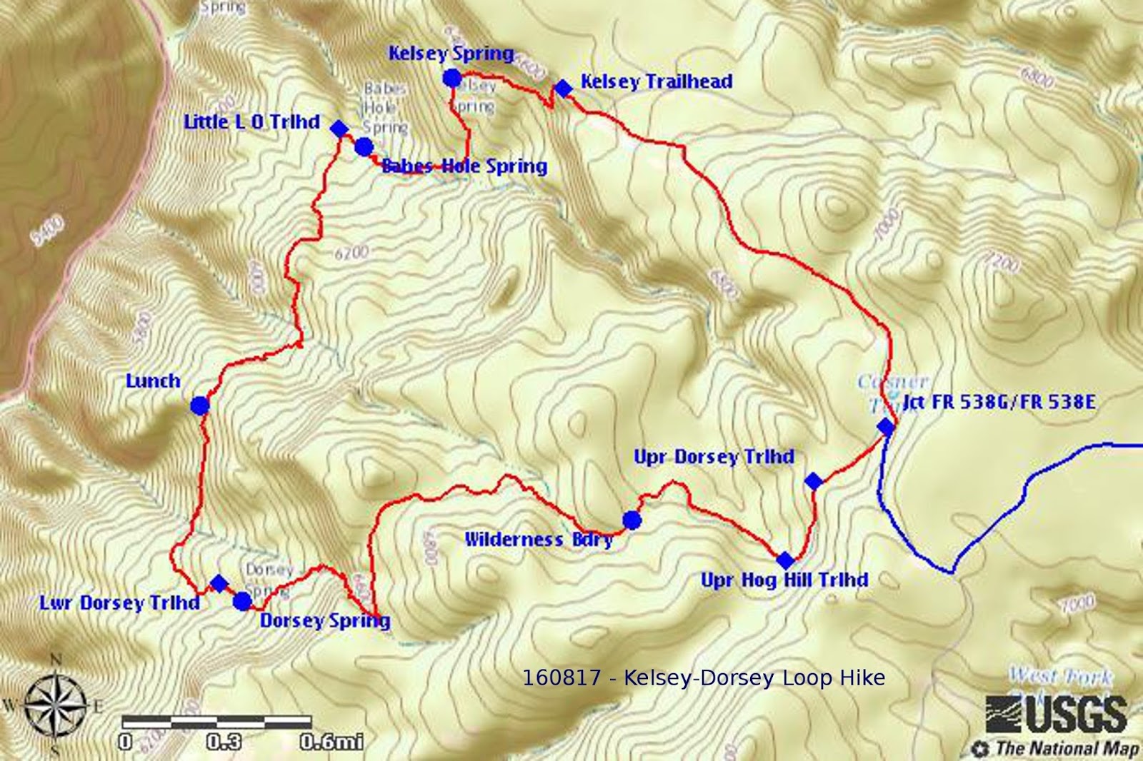


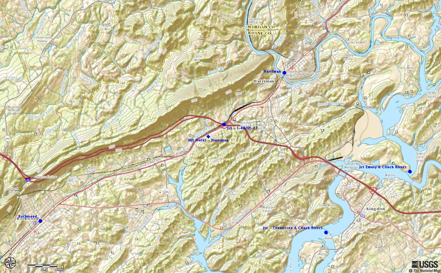


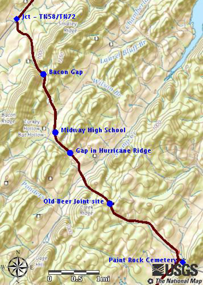


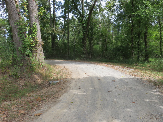


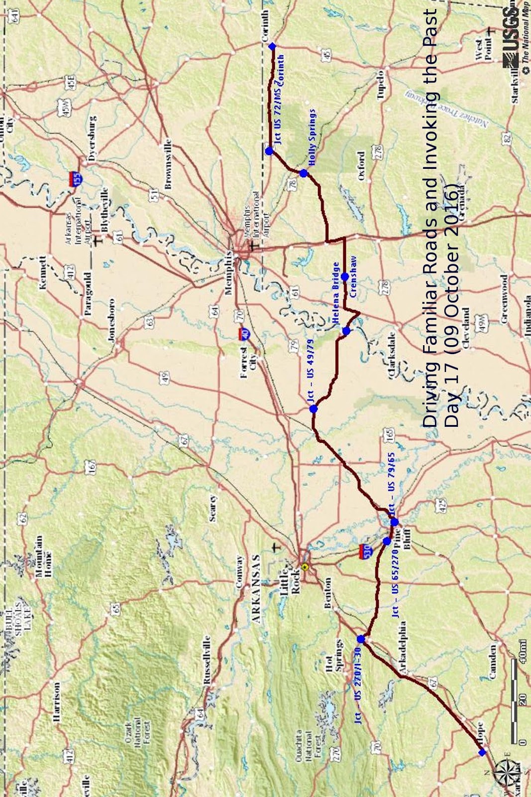


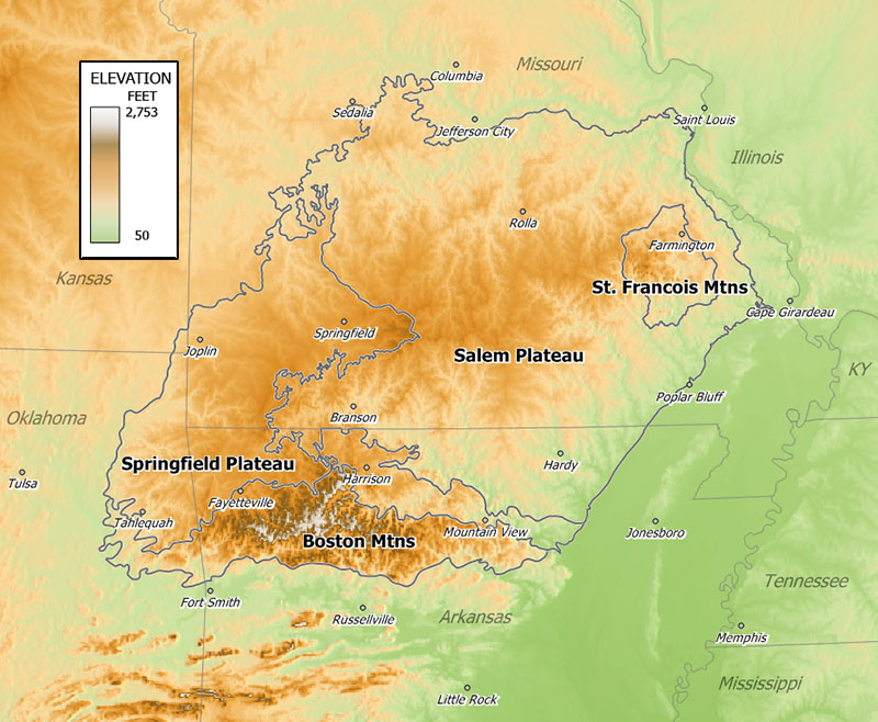