Because
of family members visiting over the holidays, I did not go on this
hike. Instead, so that we might have some record of the hike for use
in the future, Lila carried my GPS to record the track and provided
text and pictures for the report.
The
hikers parked at the intersection of Middle Verde Road and FR 119A
(also known as Granada Wash Road). This is 3.5 miles from I-17. But
be aware that the most recent Coconino National Forest Motor Vehicle
Map shows that FR 119A begins just 0.3 miles from I-17, thus
including the paved Middle Verde Road all the way to Granada Wash
Road.
Lila's
camera battery did not work and she didn't replace it until the
hikers stopped for a snack break at the top of Granada Wash. She
then had one of the hikers take a group photograph.
 |
| Left to right: Leon Girdner, Lila Wright, Loren Pritzel, Joann Hennings, Daisy Williams, Mark Purcell, Anita Jackson, Collene Maktenieks, Gary Jacobson, Betty Wolters, Jim Manning and Joyce Arregui – photograph by Name Withheld |
Lila
noted that there were 14 hikers in the group, two of whom are not
shown in the photograph.
There
was no sign identifying Granada Wash, or Granada Wash Road (now FR
119A) but one of the hikers thought it was Granado Wash. Lila later
checked her map and could not find a name for the wash. She did,
however, discover that Granado means pomegranate tree1,
and also sometimes means noble.
In fact the name of the wash turned out to be Granada (not Granado),
and she also found that granada means pomegranate fruit
and could also mean hand grenade.
2,
3
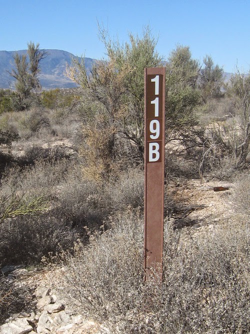 About
0.3 miles along from the place where the hikers stopped for a snack,
they came to the junction of FR 119A with FR 119B (right).
FR 119A turns to the northeast and continues on to connect with
Cornville Road at the Cornville Road/Beaverhead Flat Road junction.
According to Leon Girdner who grew up in this area, what is now FR
119A was once part of the main road between Camp Verde and Cornville.
About
0.3 miles along from the place where the hikers stopped for a snack,
they came to the junction of FR 119A with FR 119B (right).
FR 119A turns to the northeast and continues on to connect with
Cornville Road at the Cornville Road/Beaverhead Flat Road junction.
According to Leon Girdner who grew up in this area, what is now FR
119A was once part of the main road between Camp Verde and Cornville. About
1.2 miles after turning onto FR 119B, the hikers crawled under a
fence (left), luckily one with a
smooth bottom strand, and bushwhacked up to the summit of a small
hill to eat lunch with a view. Hikers are shown at lower left, the
summit is at upper right.
About
1.2 miles after turning onto FR 119B, the hikers crawled under a
fence (left), luckily one with a
smooth bottom strand, and bushwhacked up to the summit of a small
hill to eat lunch with a view. Hikers are shown at lower left, the
summit is at upper right.
Looking
north, they had a good view past Cornville and the red rock country
to the snow capped San Francisco Peaks. To the northwest they could
see across Oak Creek, the Verde River, Cottonwood and Jerome to the
Black Hills beyond.
 |
Looking past Cornville and the red rock country to the San Francisco Peaks
|
 |
Looking across Oak Creek, the Verde River, Cottonwood and Jerome
|
The
view directly west showed another slice of the Black Hills on the
horizon. In the photograph below, Mingus Mountain is just right of
center. Black Canyon, where we plan to hike next week, is located
just to the left of Mingus.
 |
The Black Hills on the horizon
|
 On
the return hike, several members of the party forsook the road part
way down Granada Wash in favor of traveling down the streambed
(right). Lila reported that the
bottom of the wash was sandy and that the walking was easy with only
a few small rock ledges that were easily descended.
On
the return hike, several members of the party forsook the road part
way down Granada Wash in favor of traveling down the streambed
(right). Lila reported that the
bottom of the wash was sandy and that the walking was easy with only
a few small rock ledges that were easily descended.
The
below photograph shows
an overview of the streambed down the wash with sections of the
forest road visible to the left and a bit of the Black Hills visible
in the distance.
 |
Looking down Granada Wash
|
The
detour down the streambed added only 0.2 miles and about 5 minutes to
the hike.
The
total hike distance was 8.7 miles, the highest elevation was 3670
feet and the total ascent was 1195 feet.
The
red GPS Track on the included map (next page)
shows the hike in; the blue track shows the detour made on the return
hike.

1http://www.spanishdict.com/translate/granado
2http://dictionary.reference.com/browse/grenade
3http://www.spanishdict.com/translate/granada
No comments:
Post a Comment