We
hiked on Kelsey Trail in Sycamore Canyon on 2 May 2015. Leaving
Cottonwood at 0600, we drove through Sedona on Hwy 89A, continued up
Oak Creek Canyon to turn left onto Forest road 535 between mile
markers 390 and 391. We followed FR 535 for about 5 miles and then
turned onto FR 536 and continued for around 4.5 miles before turning
onto FR 538. We then followed FR 538 for approximately 5.5 miles to
its junction with FR 538G.
Today
we planned to hike on Kelsey and Little LO Trails to Geronimo Spring
and the site of a homestead where Leon Girdner, who hikes with us on
occasion, lived as a child. Leon was unable to join us today, but he
did provide the name of a relative who lives in Flagstaff. We were
to meet that individual and some of his friends at the FR 538/538G
junction at 0830. On arriving at the junction a few minutes late,
Lila called the number provided by the Flagstaff contact to determine
whether he had continued on toward the trailhead, about 1.7 miles
from the junction. Unfortunately his cellphone was turned off and
she got no answer, so we continued on hoping to meet at the
trailhead.
We
had been warned that FR 538G was rough and we did find it unsuitable
for other than high clearance, 4-wheel drive vehicles. One of our
hikers, having driven a regular pickup because we were camping out
and he intended to sleep in his vehicle, had to park before we
reached the Kelsey Trailhead. But that wasn't a problem as we had
room for him in another vehicle and would be returning this way
before we camped for the night.
We
found the trailhead deserted when we arrived and waited for a short
while, still hoping to meet with the party from Flagstaff. Lila
tried calling again and still got no answer. We finally started our
hike just after 0900. Later, we determined that the Flagstaff group
had shown up at the appointed meeting place after we left, being even
later than we were, and waited for us there until 1000.
We,
meanwhile, after spending some time arranging our packs and
investigating the area around the trailhead, passed through a stile
and started our hike down Kelsey Trail into Sycamore Canyon. The
stile was built on the model of a kissing gate but instead of a
swinging gate to prevent the passage of cattle, it depends on a
narrow opening and a 180 degree turn.
 |
Stile at Kelsey Trailhead. A sign-in box is shown at right
|
 About
0.5 miles from the trailhead we came to Kelsey Spring, marked by a
wide green, seep area and a clump of wild irises (right).
About
0.5 miles from the trailhead we came to Kelsey Spring, marked by a
wide green, seep area and a clump of wild irises (right).
A
metal tank is provided near the upper edge of the seep area to
provide a wildlife watering hole.
The
trail was mostly clear and easy to follow as it descended into
Sycamore Canyon. We did, however, come to one relatively short
section that required a bit of care as it dipped into a wide wash and
followed the rocky bottom for awhile before emerging on the other
side.
 About
0.8 miles below Kelsey Spring and shortly after crossing the wash, we
came to Babes Hole Spring (left).
This spring is encircled by a rock wall to prevent its being filled
in by collapsing dirt walls and has boards placed across the top to
protect it from debris that might fall from above.
About
0.8 miles below Kelsey Spring and shortly after crossing the wash, we
came to Babes Hole Spring (left).
This spring is encircled by a rock wall to prevent its being filled
in by collapsing dirt walls and has boards placed across the top to
protect it from debris that might fall from above. An
opening, obscured by the covering boards, allows water to flow freely
from the spring to collect in a pool (right)
just below the spring. Wildlife is indeed endowed with an unusual
amount of water in this area.
An
opening, obscured by the covering boards, allows water to flow freely
from the spring to collect in a pool (right)
just below the spring. Wildlife is indeed endowed with an unusual
amount of water in this area.
Not
more than 130 yards from Babes Hole Spring, we came to the junction
of Little LO Trail with Kelsey Trail. From here one could continue
south along the slope of Sycamore Canyon for about 2.9 miles to
connect with Dorsey Trail. From that point one could return to the
rim following Dorsey Trail or, using a series of trails, continue on
down the canyon toward Taylor Cabin and Sycamore Basin and even on to
the mouth of Sycamore Canyon at the Verde River.
Not
being ambitious enough to embark on such an extended venture, we
turned onto Little LO Trail and descended to the bottom of the canyon
at the junction of Sycamore Canyon and Little LO Spring Canyon, about
1.5 miles away. This was the steepest part of our hike but the trail
is well-developed. and not overly difficult. As we descended we
could look across the canyon to the rocky cliffs on the other side of
Little LO Spring Canyon.
 |
Bare rocky cliff across the canyon from Little LO Trail above Geronimo Spring
|
On
arriving at Geronimo Spring, located within the mouth of Little LO
Spring Canyon about 300 yards upstream from the juncture with
sycamore Canyon, we found that early settlers had left their mark in
the form of domestic irises and an apple tree.

As
was true of the other two springs we had visited, camping within 200
feet was forbidden. However, a sign pointed toward a camping area
located downstream. Although we didn't intend to camp there, opting
instead to drive closer to the hike we had planned for the next day
and camp at our vehicles, we followed the sign on to the junction
with Sycamore Creek. There we found a long flat meadow stretching up
the creek.
We
hiked for a short distance up the meadow where we found bits of old
fencing, some sections of iron piping that may have been used to
bring water from the spring, an old rock wall, the bottom section of
an old discarded wood-burning stove and another patch of domestic
irises, this time with a single, lingering white blossom. While this
must have been, in some ways, a very appealing place for the Girdners
to homestead, it was also extremely isolated.

Although
still short of midday it was turning hot when we headed back up the
steep trail from Geronimo Spring. We had decided that we would hike
until noon and stop along the trail for lunch. About a mile up the
trail, just a few minutes before noon, we found just the right spot,
a tree-shaded place that was swept by a gentle, undulating breeze.
While
still on Little LO Trail we passed a group of hikers heading down to
camp near Geronimo Spring.
In
addition to the irises already shown, we saw many other very
attractive flowers along the way. Some of these are shown below.

We
arrived back at the parking lot sometime after 1330, loaded our gear
and drove south toward Taylor Cabin Trailhead where we planned to
hike the following day.
Our
round-trip hike to Geronimo Spring and the Girdner homestead site was
4.4 miles in length. The highest elevation was 6647 feet and the
total ascent was 1514 feet.
The
area around Geronimo Spring and the Girdner homestead site is shown
on the map insert shown below. The red line is our GPS track in and
out.
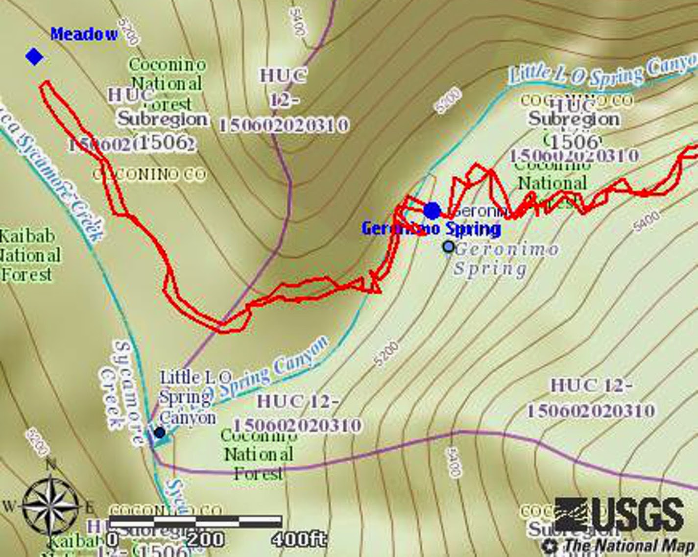
Showing
the area around Geronimo Spring and the site of the Girdner Homestead
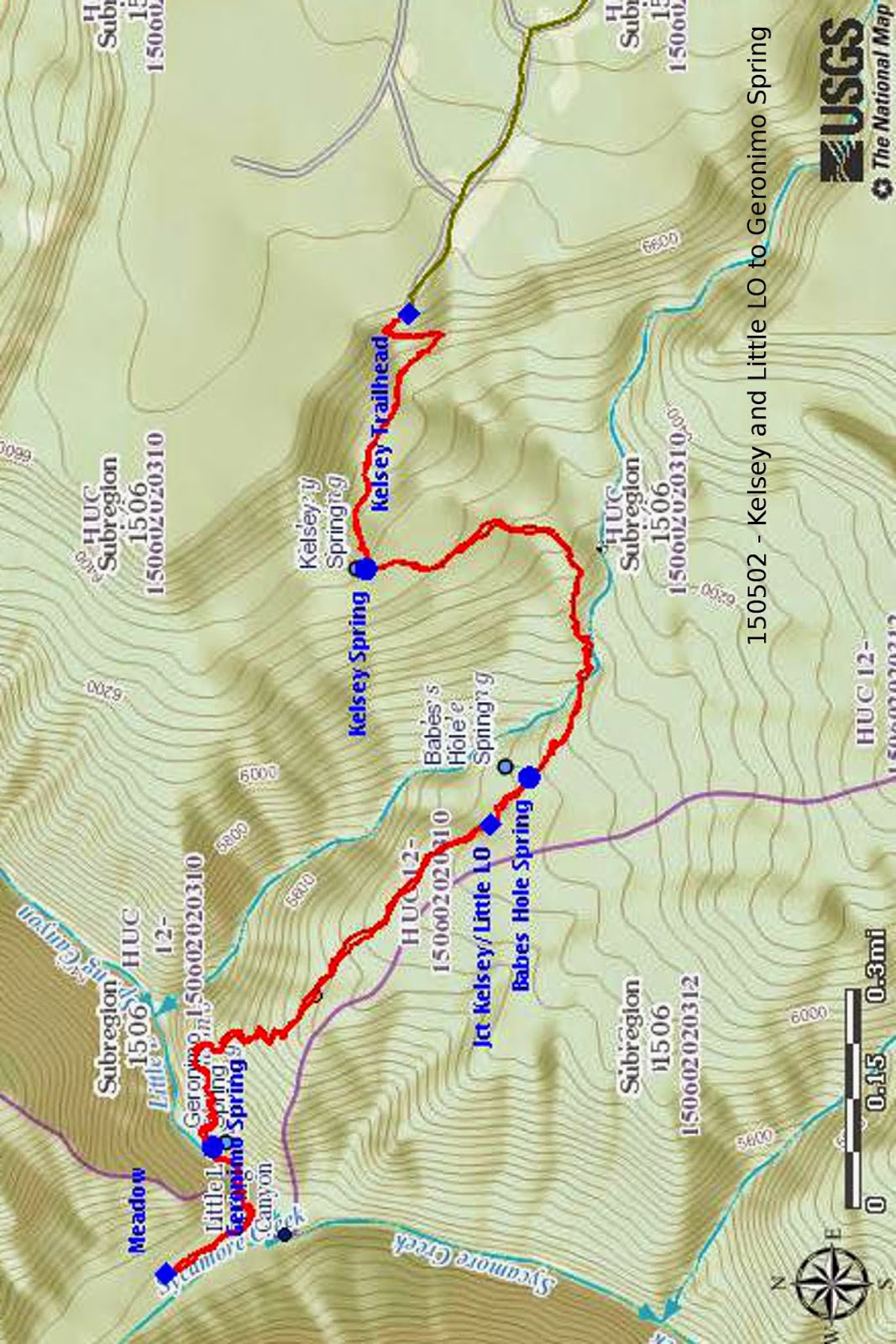
Our
complete GPS track for the hike is shown in red on the included map
(next page). The green track seen
leading to the Kelsey Trailhead is a section of Forest Road 538G.
Accompanying
me on this hike were: Lila Wright, Jim Manning, Karl Sink, Chris
Jensen and Dave Beech.
No comments:
Post a Comment