Monday, May 22, 2017

Ellis Health Update - 170522

Background

I am undergoing treatment for Stage 4 Mesothelomia Lung Cancer. The problem started with chest pains on 2 January 2017 after I returned from my workout at the gym. A trip to the emergency room resulted in a CT (computed tomography) scan that revealed a mass in my right lung. A later biopsy indicated it was mesothelioma; a sample was sent to the Mayo Clinic for a second opinion; Mayo concurred in that diagnosis and I was sent for a PET (positron emission tomography) scan at the Verde Valley Medical Center clinic in Sedona, the nearest facility with a PET machine. Following the PET scan I was referred to the Arizona Oncology Center Sedona facility in the same building. I saw Dr Anthony at the oncology center who discussed treatment options and recommended chemotherapy consisting of the following two drugs: Pemetrexed and Carboplatin, treatment I am now undergoing.

Two previous posts touch on this subject they are shown at:
and

Current Status
I underwent my fifth chemotherapy session on 17 May 2017. The doctor was happy with the associated lab results.

The laboratory results are meaningless to me. However, the most pertinent in my case (based on the doctor's emphasis) seems to be my Hemoglobin level, so I looked that up online at the Mayo Clinic website. Low hemoglobin results in anemia, a condition which is somewhat normal for me.

The specific parts of the test he seems most interested in are the HGB (Hemoglobin, the oxygen-carrying component within the red blood cells) and the HCT (volume of red blood cells in a specific volume of blood).
The lower HGB level for continuing the treatment I am undergoing is 7 g/dl.

On the 21 April test, my HGB reading was 9.9 g/dl, so I increased my intake of blackstrap molasses (for iron) and Potato chips (for sodium) and the 15 May test results showed an HGB level of 10.4 g/dl.

With the chemotherapy port in place (installed at the time of the last treatment), the treatment on 17 May went smoothly.

I have been having a problem with my eyes watering recently. The doctor called it “easy lacrimation” and suggested an antihistamine such as Benadryl. He said that should also help me to sleep during the three-day period surrounding chemotherapy treatments during which I take a steroid (Dexamethasone).

I normally have a couple of down days following chemo sessions, days on which I really don't have any pain, but just feel listless. These listless days are usually the second and third after treatment. This time was no exception. The first day after treatment, I went for a 2.5-mile walk and still felt good. The second day, still feeling good in the morning, I walked 4.7 miles and that may have been a bit too much: because by early afternoon I was really dragging. My listlessness continued through another day.


This morning, 22 May, the doctor's office called to tell me to start taking two iron tablets each day. Hopefully that will help with the anemia. Later in the morning, I got out and walked about a mile before spending most of the rest of the day watching pre-recorded TV shows with daughter Diana who is visiting for the week. I think that I am now ready for some more substantial activity and Diana and I have a 2.5-mile walk scheduled for tomorrow morning.

Friday, May 12, 2017

Ellis Health Update - 170512

At the Tuesday, 25 April visit with the oncologist we reviewed the results of the CAT scan taken last Monday along with the lab tests from the last blood draw (Friday, 21 April).  The blood tests all showed my white cell count to be OK but that I am still anemic as usual.  The doctor didn't seem worried about the anemia, but maybe I will increase my intake of salty potato chips and blackstrap molasses just in case.  The really good news is that the tumor is shrinking and in anticipation of that, based on results of the previous blood tests (the last previous to this Mondays tests), he had added something (he called it bone cement) to fill in the defects left in my rib as the cancer retreats .  Based on these results he recommended continuing the tri-weekly chemo for another nine weeks.  My next office visit and chemo is set for 17 May at 0930.

A  chemo session was originally scheduled to immediately follow the Tuesday, 25 April doctor visit; however, my blood vessels absolutely refused to cooperate.  The nurses successfully inserted needles in five different locations (pretty much without pain, I might add), but my body had apparently learned that they were trying to insert a foreign substance and just refused to accept it. That meant that the installation of a port to facilitate injections would be necessary.  The nurses said that if we could get a port installed the next day at the hospital in Cottonwood and still get to the Oncology Center in Sedona by 1400 they would do the chemo the same day.  That was important to me because I must take a steroid (dexamethasone) twice a day -- the day before, day of, and day following each chemo session.  I get little or no sleep on the days that I take the steroid and by delaying the chemo only one day, I could just continue the steroids for one more day rather than start a new three-day regimen of sleepless nights.

The surgeon at cottonwood saw me late in the day on the 25th (the day for which the chemo session was originally scheduled) and got us scheduled for surgery to install the port (Bard Power Port on right chest with a lead to an artery near the heart) early in the morning of 26 April. When he installed the port he left it ready for chemo and we were in Sedona early enough that the treatment was completed and we were home a little before 1400 on the 26th.

On arrival back home, we were faced with a sprinkler leak where I had apparently damaged the system while planting flowers the day before. That took about 45 minutes and when finished I was feeling spry enough that I finished clipping the already-bloomed irises except for the few alongside the backyard steps/walkway that were still in bloom. The exercise did me good after being confined to hospital beds, wheelchairs, car seats and chemo-treatment chairs for almost eight hours.  The only good part of that confinement was that I knew nothing from the time they wheeled me into surgery until they were ready to take me out again and that I managed to get in a couple of quick naps while undergoing chemo. With the port in place, the chemo went very smoothly.

The few days following the port installation and chemo session, were pretty rough. I had diarrhea for two days and, a severe reaction to the anesthesia used during the surgery to install the port. I did not feel up to resuming my daily walks for several days. After that I recovered nicely and even went for a 3.2-mile walk to Tavasci Marsh with the Skyliners Wednesday walking group on 10 May. I blame most of the problem on an adverse reaction to anesthesia and expect the chemo session scheduled for next week to go smoothly.

Before completing and posting this report, I waited for the doctor's visit report. Arizona Oncology has a website that should make such information available. However the website provides nothing resembling office visit reports. They do complete the reports in a timely fashion and I thought that I had requested that they mail me a copy as soon as it was completed. However, I apparently failed to make clear what I wanted and, after waiting a week, I called to find that they had not understood what I wanted. To make matters even worse, they really did not understand what I was calling about and I had to call again the next week. Finally, after talking directly to the doctor's assistant, I received the report in the mail today, just five days before my next scheduled visit.


Wednesday, May 10, 2017

Hike to Tavasci Marsh


Lila Wright, leader of the Skyliners hiking group, recently added a separate weekly hike that she calls a “walk” to the regular October through May schedule of hikes. The regular hikes are still scheduled for Saturdays. The weekly walks, however, are scheduled for Wednesdays, thus allowing those who wish to participate in both activities to do so.

Today, 10 May 2017, the Wednesday “walk” was scheduled to be along the river starting at the old Jail in Cottonwood and ending at Tuzigoot Bridge. However, the day was a little chilly and that trail would be largely shaded by the trees growing along the river. Because of this, she switched hikes and we hiked from Tuzigoot National Monument to Tavasci Marsh instead, delaying the hike along the river until next Wednesday. Never having been to Tavasci Marsh before, I was pleased with the change.

We carpooled from the Safeway parking lot in Cottonwood through Old Town, turned onto Tuzigoot Road and were shortly at the Tuzigoot National Monument parking area. There is a $10.00 per person charge for entering the monument but, luckily no charge for parking. We were thus able to park there for free, skirt the monument entrance, and hike along a concrete walkway that leads about 0.35 miles from the north end of the visitors center down the spine of a ridge to an overlook on the west side of the marsh. We turned off the concrete walkway about 0.1 miles from the visitor center onto what was once a section of Tuzigoot Road and descended the ridge.

This overlook and the concrete walkway to it are described in an article posted at gjhikes.com1. That article notes that there is a $5.00 fee for persons over the age of 15. Our leader told the ranger at Tuzigoot what we were doing and we did not pay a fee, perhaps because we were not going all the way to the overlook on the west ridge. The same article also notes that the marsh is named after the Tavasci family who “ran a farm there from 1928 to 1991.”

Biologist and local resident Doug Von Gausig, is quoted in a 23 April 2001 article in the Verde Independent Newspaper as follows:

"It was a cattle pasture," He explains. "A dairy reclaimed it as pasture land and that destroyed Tavasci Marsh for 50 years." 

According to Von Gausig when Arizona Game and Fish along with the land's owner Phelps Dodge allowed the beaver dams to return, the marsh slowly, "recreated itself in a natural fashion. They created a new habitat that had to gather new species."2

The following photograph of the concrete walkway to the marsh overlook on the west ridge was taken looking back toward the Tuzigoot Visitors Center. The walkway is almost completely hidden from the parking lot.

Looking back toward visitors center and parking lot from concrete walkway
A number of plants growing along the walkway were identified by signs. Some of these are shown below along with identification and usage information.

Catclaw Acacia (right). This is a plant with claw-like thorns that you will never forget if you stumble into one while on a hike. The associated sign includes the following information: “On long journeys, ancient travelers relied on the fruits for food. The green seed pods can be eaten fresh or dried, or ground into flour to make mush, cakes or bread. The branches make good drumsticks and furniture. Bees that feed on the blossoms produce a delicate and distinctive honey.”

Four-Wing Saltbush (left). The associated sign provides the following information: “Named for the four-winged bracts on its fruit, this common high desert shrub provides food and medicine and is burned during ceremonies. The leaves, young shoots, seeds, and fruit are edible.” The sign goes on to say that the ashes from burned leaves make a baking soda that fortifies “baked goods with calcium and minerals.” Additionally, it says the leaves can relieve pain when chewed and applied to insect stings.

That use of saltbush leaves reminded me of an old folk remedy from my childhood. Grandmaw chewed tobacco leaves and applied them to bee stings when we children got too close to Grandpaw's bee hives. What made this use of tobacco leaves so memorable was that Grandmaw was adamantly opposed to the chewing of tobacco, declaring it to be the nastiest of habits, and would not allow the men in the family to do so in her house. She would have no nasty spittoons scattered about the premises and would not allow anyone to spit tobacco juice in the fireplace. Strangely enough, we later learned that she put aside a couple of hands of tobacco leaves each year and kept them hidden in the back room along with a small silver knife. She would then, on rare occasions, quietly sneak into the backroom, use the silver knife to cut a dainty plug and chew away to her heart's content. We never did find out where she expelled the chewed leaves and the juice except, of course, on those occasions when it was for medicinal purposes.

But enough of this trip down memory lane. One other plant that was identified along the walkway to Tavasci Overlook was Mormon Tea (right). The sign in this case was so far from the plant being identified that one could choose from several different plants. In other words had we not already known what Mormon tea looked like, we would not have learned to identify it from this sign. According to the sign, “Southwesterners add the dried stems of this shrub to hot water to brew a popular and tasty tea. Slightly bitter to the taste, it is a mild stimulant similar to coffee. Medicinally, Mormon tea is an antihistamine and relieves cough and allergy symptoms.” I have tasted Mormon tea and can attest to its slightly bitter taste. I did not find it unpleasant; however, I prefer green tea. As to the medicinal properties, I have never tried using it as an antihistamine.

As already noted we followed the concrete walkway for only about 0.1 mile and and turned down a dirt trail (an old road) to descend the ridge. This was the only part of the hike that was not essentially level. Even here the descent was only around 35 feet in about 150 yards.

We were traveling almost directly south as we descended the ridge. At the bottom we turned generally northeast and continued for about 0.3 miles to very near the southwest corner of the marsh. The trail then made a sharp turn to the south (actually ,at first, a bit to the southwest) and continued for 0.5 miles before turning back north to the southeast corner of the marsh where we found the below sign.

Sign posted at the edge of Tavasci marsh
In effect our track had formed the shape of a large jug about half-a-mile deep with an opening at the top that was about a tenth-of-mile wide. In looking at old maps, I determined that the top of the jug was once closed by a section of Old Tuzigoot Road, shown by the short straight yellow line in the map below map.

The trail takes the form of a large jug with a quarter-mile opening at the top
I am not sure whether it would still be possible to follow Old Tuzigoot Road directly across the neck of the bottle, The marsh may have reclaimed that section of road. In any case, the walk around the bottle was a pleasant stroll along a level section of trail, so there was really no great incentive to shorten the hike.

About 0.2 miles beyond the Tavasci Marsh welcome sign, we came to the east overlook, a sturdy, recently-built platform from which one could view the marsh and the wildlife it supports. Unfortunately, at the time of our visit wildlife was scarce. We saw only a couple of redwing blackbirds. However, I understand that the marsh is normally a great place for bird watching. We paused for a time at the outlook looking out over the marsh.

Across the way we could see the west over-look (telephoto view, left) at the end of the con-crete walkway. It was perched high on the ridge west of the marsh as opposed to being at the very edge of the marsh as was true of the one where we stood.

The photo-graph shown here (right) shows a bit of the marsh and a corner of the east overlook platform located at its very edge.

Before leaving the viewing platform, I took a series of photographs that I could stitch together into a panoramic view of the marsh.

Panoramic view of Tavasci Marsh
On the return trip just past the southernmost tip of the trail (that is just past the bottom of the jar), several of the hikers broke off and followed the Old Tuzigoot Road along the river to the river access point (boat ramp) near Tuzigoot Bridge. One member of the breakaway party carried my GPS so that we would have a recorded track for that route. They came out at the large parking area provided for the river access point. The trail ends at the posts shown in the photograph (left), taken from the parking lot.

The included map (below) shows the track from the visitor center to the east overlook (heavy red track), the route along the river to the river access point (light red track) and other points of interest mentioned in this report.


The hike from the visitor center to the east overlook and then on to the river access parking area was 3.5 miles. The highest elevation was 3380 feet and the total ascent was 218 feet.


1http://www.gjhikes.com/2013/03/tavasci-marsh-overlook.html

2 https://www.verdenews.com/news/2001/apr/23/the-bird-man-of-tavasci-marsh

Wednesday, April 12, 2017

Kachina Trail


On Saturday, 03 September 2011, nine hikers from Cottonwood and Sedona, hiked on Kachina Trail between Snowbowl and Weatherford Trail. Three hikers left Cottonwood and stopped at Coco’s in Flagstaff for breakfast, four left Cottonwood and drove straight to Snowbowl and two left Sedona and drove straight to Snowbowl.

From Flagstaff, we took US-180 W and followed it about 7.0 miles before turning right onto Snowbowl Road. After another 6.2 miles on this road we arrived at the parking lot for Kachina Trail at the Snowbowl. The Kachina parking lot is located on the right just a few yards beyond the left turn into the Humphreys Trail parking lot. It is a long, narrow lot and we drove to the back end to park near the Trailhead.

The trail leads from the end of the parking lot immediately into a mixed aspen and conifer forest, a most pleasant place to hike on a hot summer day. We noted a sign at the trailhead proclaiming Kachina to be a “more difficult horse trail.” We decided that it must be so classified because of the ancient rock slides the trail navigated along the way.

Near the beginning of Kachina Trail at Snowbowl
The trail would its way through the forest, ascending and descending the small ridges along the slope of the mountain and crossing rocky areas along the way. Except for a few rocky portions the trail was fairly easy and we found that the elevation change for its entire length was less than 600 feet – 528 as measured on my GPS. However, because of the ridges we climbed a lot more than that.

Shortly after starting the hike we entered the Kachina Peaks Wilderness and then came to an opening in the forest made for a power line. We stopped there for a group photograph, courtesy of George and “Wally the tripod.” I really haven’t learned to use the time delay feature on my camera; however, George has it down pat and we always get a shot of the entire group (photographer included) when he is along.

Left to right: (standing) Miriam Sterling, Lila Wright, Betty Wolters, 
the author, Gordon Bice, Name Withheld; (kneeling) Akemi Tomioka, 
Kwi Johnson and George Everman – Photo by George with “Wally”
As we continued along the way, we had glimpses through the trees of Flagstaff and the country to the southwest of us laid out below. George, always on the alert, found a variety of mushrooms along the trail and lagged behind to examine them. There were also a number of flowers to be seen as we hiked and George and Akemi took time to examine a particularly handsome New Mexico Verbena (left – by George or Akemi) more closely.

About 2.5 miles from the trailhead we at a small meadow for a snack and a rest break.

George decided to explore arrangements for shelter should he ever be stranded in the area and found himself a handy hollow log.

George nicely sheltered from the elements- photograph by Akemi
Following our snack break, we hiked about another 1.5 miles and stopped again for a breather and to try our hands at a group art project. Each member of the group contributed an etching for the tree fungus art shown below. (NOTE: Once the etchings are made, and the fungus is allowed to dry, they become permanent and are often sold in tourist shops.)

Skyliner group art – photograph by George
Most of the party wanted to turn back at that point; however, I wanted to make a GPS track of the entire trail. After some discussion George, Akemi, Kwi, Gordon and I continued on while the others turned back.

The trail continued on through the forest, now interspersed with more frequent open meadows. We passed through areas that were filled with lush, waist-high ferns. The trail itself was pretty well trodden; however it was so overgrown by ferns and grasses that one could easily miss it looking from an angle.

Looking across a meadow along Kachina Trail
The trail joins Freidlein Prairie Road, now nothing more than a trail, about 0.3 miles short of Weatherford Trail. The sign (right) shown here is directly across the old road where Kachina joins it and the turn is obvious. We saw some faint signs that something might have been dragged along the old roadway sometime in the recent past. Otherwise, there were no signs of anything but foot traffic, so I suppose it must be closed to vehicle traffic further down the slope.

Just a few minutes later, we came to our goal, the end of Kachina Trail at Weatherford Trail, about 1.7 miles from Schultz Tank. It was just after noon and a good time to stop for lunch. I ate rapidly and then settled in for my noon nap, while the others rested and admired the scenery.

Ellis and the noon nap – photograph by George
George awakened me after 30 minutes as we had arranged and we packed up and headed back. I soon became aware that we were short a hiker and was told that Kwi had headed back to join the group that had turned back earlier. We try to discourage people from hiking alone; however, it didn’t seem to be a problem in this case as the trail was clearly defined and it would seem impossible to get lost. But, when we got back to where Kachina Trail turned off from Freidlien Prairie Road, two of our party marched blithely past the turnoff and we began to worry that Kwi might have done the same. We later found another spot where the trail turned to climb up a rocky ridge that one could easily have gone astray. We used cell phones to contact the rest of the party and found that she had not yet joined them. Fortunately, by questioning hikers we met traveling in the other direction we soon learned that Kwi was still on the trail ahead of us, and she did join that group about the time they reached the trailhead.

This was an 11.4-mile round-trip hike. The highest elevation was 9341 feet and the total ascent was 2256 feet.

Our GPS track is shown on the included map (below).


Wednesday, March 22, 2017

Weatherford Trail


Buoyed by a sunny forecast, five of us gathered at the Safeway parking lot in Cottonwood at 0500 on 16 July 2011 for a hike on Weatherford Trail. We drove to Flagstaff and stopped at Denny’s for breakfast. After breakfast we continued on into Flagstaff, took US-180 W and followed it about 3.2 miles before turning right on Schultz Pass Road. We followed Schultz Pass Road about 5.3 miles to the trailhead parking lot at Schultz Tank. The turnoff to the parking lot is on the right (south) side of the road. We arrived at the trailhead at about 0740. A toilet is provided at the parking lot.

Donning our gear we found a sign (right) on the north side of the lot marking the Weatherford Trailhead. The trail started out at a gentle slope that varied very little all the way to our destination at Doyle Saddle. NOTE: A very short distance up the trail from the parking lot we crossed an old road. On the north side of this road, a sign says Weatherford Trail while on the south side it is signed as Schultz Trail. Go figure.

About 2 miles (by GPS; 2.4 according to signage) from the parking lot the Kachina Trail leads in from the left. We continued on up the mountain on Weatherford, and shortly entered the Peaks Wilderness area.

We paused along the way for an occasional rest break and after a couple of hours for a snack break and a group photograph (below). We had a long way to go and so didn’t linger for very long. The trail continued its gentle slope along the old road that, according to the forest service, originally carried passengers to the peaks via Model T Fords. Higher up the trail became pretty rocky. Gordon described it as walking on egg-sized marbles. It is really not too bad as long as you step carefully, and it does maintain the same gentle slope all the way.

Left to right: Donna Goodman, Gordon Bice, Dolly Yapp and Betty Wolters
Gordon and I had hiked on ahead a short distance and waited for the rest of the group to catch up. I took the below photograph as the rest of the group were arriving.

Left to right: Betty Wolters, Dolly Yapp and Donna Goodman at rest stop
We had, according to my GPS, come 5.8 miles from the trailhead. Hearing this, Dolly and Betty, declared that as they had only signed up for an eleven mile round trip hike, this was enough, and they would stop to eat lunch start back.

Our hoped for destination was Doyle Saddle where we would be able to look down into the Inner Basin and up to Humphrey's Peak. So, leaving Dolly and Betty eating lunch, Gordon, Donna and I pressed on, hiking another 1.9 miles according to the GPS before reaching Doyle Saddle. By the time we arrived it was 1220; we were tired and ready to eat. We could see Humphrey's Peak ahead and Dona and Gordon were able to pick out where they had been on a hike on Abineau Trail earlier this year. The inner basin was below us but we really couldn’t see much of it from the saddle. We ate lunch, I took a nap and shot a few photographs and we headed back.

From Doyle Saddle - Humphreys Peak (against the sky at upper left)
From Doyle Saddle – Looking back toward Flagstaff. Weatherford
Trail is seen to the left in this photo
We didn’t note what time we left Doyle Saddle; however since I did manage to get in a nap and we spent a bit of time enjoying the view we must have spent most of an hour there. I will estimate that we started back down about 1315.

The far-off views all along Weatherford Trail were spectacular now that we were facing down the mountain and we were torn between looking far away and watching our step on the loose, round pebbly surface of the old tourist road the trail follows.

We stopped often just to look without the bother of switching our view to look where we were stepping. The below photograph, with a view of Flagstaff and beyond from just below Doyle Saddle, was taken during one of these stops.

View looking out over Flagstaff – Taken from Weatherford Trail just
below Doyle Saddle
We arrived back at the trailhead at 1645 to find Betty and Dolly waiting for us. According to the sign at the trailhead, the distance to Doyle Saddle is 6 miles and our round trip hike would have been 12 miles. However, the one-way distance as measured by my GPS was 7.8 miles, making it 15.6 miles round trip. I don’t know which measurement is more accurate; however, my feet were telling me to go with the GPS reading. The highest elevation was 10877 feet and the total ascent was 3138 feet.

The GPS elevation readings were 8047 feet at the trailhead and 10877 at Doyle Saddle, an elevation difference of 8030 feet.

Our track is shown on the included map (below).


Red Rock Park to Gooseneck Bend


On 12 March 2011, fourteen Skyliners traveled north from Cottonwood on 89A and turned on Lower Red Rock Loop Road. We drove the entrance to Red Rock State Park, turned and parked alongside the road at the Lime Kiln Trailhead across from the park entrance. George and Akemi had traveled from Sedona and were waiting for us there. The below plaque is mounted at the trailhead.

Plaque mounted at Lime Kiln Trailhead at Red Rock State Park
From the trailhead Lime Kiln Trail first runs to the southeast parallel to Lower Red Rock Loop Road for about 0.1 miles, crossing a wash along the way, and then turns sharply up the slope of Scheurman Mountain. The trail climbs around 400 feet in 0.9 miles to cross a lower ridge on the south slope of Scheurman Mountain and then descends to cross Lower Red Rock Loop Road heading generally west. About 1.0 mile from Red Rock Loop Road, where Lime Kiln Trail follows a dirt road, we came to a fork in the road. At this point, we took the left fork, leaving Lime Kiln Trail. This fork is marked as 9845H, although the marker is a metal stake, partly hidden in the bushes and cannot be read until you pass it and look back. After following Road 9845H for about 0.1 miles from Lime Kiln Trail, we came to Horse Trail A. This trail actually crosses the road at this point; to continue toward Oak Creek at Gooseneck (sometimes called Horseshoe) Bend we turned left onto the horse trail. A metal stake bearing the letter A identifies the trail.

About 0.25 miles from 9845H, Horse Trail A enters an old road. We continued along this road going uphill to arrive at a saddle in the ridge overlooking Oak Creek above Gooseneck Bend. At the saddle in the ridge, we left the old road and continued on the horse trail going downhill to the southeast toward Oak Creek. About 0.25 miles from the saddle in the ridge and just above Oak Creek, the Indian ruins were visible in the cliff across a wash to our right. At this point, we could either (1) turn off the trail to the right and find a place to cross the wash and climb the hill to the cliff or (2) continue down the horse trail to a fence, apparently designed to keep stock from entering Oak Creek, and follow that up the hill to the cliff. We chose the second option.

Note the rock wall built under the overhang. This could be either 
Indian Ruins or a latter day fake?
At the bottom of the hill, part of the group made the steep climb up the hill along the fence to reach the ruins. The rest of the group continued straight ahead and found a nice lunch spot at the foot of a cliff alongside Oak Creek. We all ate lunch, some at the ruins, some alongside the creek, before heading back

After eating my lunch at the ruins, I made my way directly down the steep slope toward the creek rather than follow the fence back. I then walked up a dry wash alongside the creek to join the rest of the group before starting back. Along the way I found the below pictured log fabricated by some industrious beaver. Following lunch we all gathered for a group picture before heading back.

Left over building material from a beaver construction project
Left to right: The author, Daisy Williams, Dolly Yapp, Name Withheld, Miriam 

Sterling, Marvin Alt, Jim Manning, Unable to contact, Donna Goodman, 
Connie Woolard, Bill Woolard, Akemi Tomioka, Jan PreFontaine, George 
Everman, Lila Wright and Fran Lind – photo by George with time delay
The photograph below shows Oak Creek at the apex of Gooseneck Bend where most of the group stopped for lunch.

Apex of Gooseneck Bend in Oak Creek – photo by George
According to my GPS file, we hiked 6.6 miles. The elevation change was around 530 feet. Those who retraced the entire hike route on the return trip ascended a total about 1050 feet. For those who returned part of the way by hiking along Lower Red Rock Loop Road, and thus did not climb back across the foothill of Scheurman Mountain, the total ascent was around 750 feet.

Our GPS track is displayed on the included map (below).


Friday, March 3, 2017

The Neighborhood Walk


As most of you know, I was recently diagnosed as having lung cancer (mesothelioma, stage 4).

After my second session of chemotherapy, I was feeling well enough that I decided to incorporate a walk around the neighborhood in my daily schedule. I walk the same 1.5-mile route each day, starting at the mailbox on the street in front of our house and heading south on S Arroya Vista Drive.

The walk takes me past Mescal Drive, the street that fronts our property on the south, across Christina Draw, past Brook Hollow Drive and to the south end of S Arroya Vista at the top of the hill. There the street turns right (west), becoming Meadowlark Drive. The view from our house to the end of S Arroya Vista Drive is shown here (below).

Looking from our mailbox across Christina Draw and on to the end 
of S Arroya Vista Drive at the top of the hill.
Although it is not immediately obvious from the above photograph, a substantial wash runs down Christina Draw and under S Arroya Vista Drive. The wash is normally dry; however, it drains a large section of the eastern slope of Mingus Mountain south of Allen Spring and north of Black Canyon. Heavy heavy rains on the mountain above can turn it into a raging monster of a stream. The below photograph was taken in March 2007.

Christina Draw Wash in March 2007
The distance to the turn onto Meadowlark Drive is 0.2 miles. Meadowlark Drive then leads along a level ridge for a short distance before descending to end at Christina Draw Wash, about 0.4 miles upstream from the S Arroya Vista Drive crossing. The view while walking west on Meadowlark extends to the top of Mingus Mountain.

View looking west on Meadowlark Drive – Mingus Mountain on the horizon
Just 0.3 miles from Arroya Vista Drive Meadowlark comes to an abrupt end (right) at the wash.

There, I was faced with a dilemma. If I turned back here, my walk will be only about a mile long. And all of that would be on paved surfaces. I really wanted to walk a bit farther and wanted to include some distance along a rougher surface to give my ankles a workout. Nothing is more irritating to me than a sprained ankle.

After examining the wash and determining it to be open and relatively easy hiking, I decided to give it a try.

Christina Draw Wash from the end of Meadowlark Drive
The wash turned out to be the most interesting part of the walk. It is open and free of large boulders all the way from Meadowlark to Brook Hollow Drive, a distance of 0.3 miles. Below Brook Hollow it tends to close in a bit with overhanging growth and a less open path. Since it is rattlesnake season and I would be traveling alone, I decided to avoid the section between Brook Hollow Drive and Arroya Vista Drive, leaving the wash at Brook Hollow.

The wash , except perhaps for changes in stream flow caused by the construction of houses in recent years, remains in its natural state with the exception of some erosion prevention measures along a single property.

Rock wall built for erosion protection along Christina Draw Wash
On my way past that property, I found the owner out working in his back yard and stopped to chat. Angel Vargas, a widower, has lived there and battled the wash for some thirty years. Angel served in the Navajo Army during the Korean War and in the National Guard; he retired from the Navajo Army Depot in Bellemont in the 1980s.

The stone wall seen above roughly corresponds with the location of the bank when he moved in. His battle continues as he reinforces the bank with various materials salvaged from a variety of sources, including discarded WWII practice bombs (left) from the Army depot where he worked.

In the photograph below a line of these old practice bombs can be seen serving as the base of a section of retaining wall.
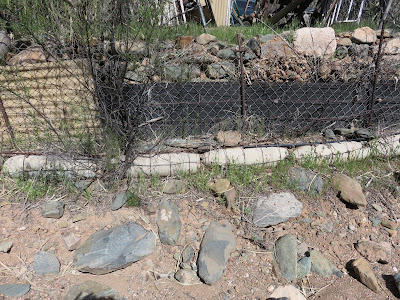

Practice bombs serving as the foundation for a section of Angel's retaining 
wall
Angel's accumulation of treasures rescued over the years include an old 6-cylinder engine and a horse-drawn turning plow, both once used on the Alvarez Ranch in Sycamore Canyon where Angel grew up.

Old 6-cylinder engine
Old horse-drawn turning plow
The engine could have been used to drive a water pump for irrigation. The owner of a small portable sawmill where I once worked as a teenager used an engine very much like this one to power his mill. AS for the old turning plow, I spent many youthful hours following behind one of those pulled by a team of mules.

Another memory from long ago was brought to mind by an old horse-drawn scoop. I used one of these when I was about 14 years old to clean out a pond on our farm.

A horse-drawn scoop
I really do not look back on the days Angel's collection of equipment called to mind with a lot of longing. I never learned to actually enjoy such work. At the time, I thought it was just because I was rather lazy. However, in retrospect, I think that I just wasn't interested. The best thing I can say is that such hard labor led me to join the Navy.

Angel's front yard, in contrast to the collection of artifacts in the back yard, is quite neat and orderly.

Angel's front yard
High on the bluff just across the wash from Angel's home is a large house (right) that is presently for sale and he is making an effort to, in his words, “clean up my back yard” so as to present a better view to prospective buyers. In my opinion almost everything he has collected has long since entered the status of “artifact” and can by no means be called junk. I call the place Angel's Museum; I certainly hope that he doesn't go too far in his clean-up efforts.

My feelings about “junk” may be influenced by memories of my Grandpaw Wicker's junk yard. Grandpaw was a farmer, a carpenter and a sawmill operator who also owned a thresher that he used during wheat and oat harvesting season to thresh grain for other farmers, collecting a toll for the service.

He bought all of his equipment second hand and repaired and maintained it himself. He seemed always to have a tractor, a truck or some other piece of equipment under repair. When something was simply beyond its useful life, it was never completely discarded but was instead moved to a location under a large oak tree that was called the “junk pile.” There it would reside just in case some part of it became useful for repairing some other piece of machinery. As a result I have always thought of old machinery as stuff that might be useful someday.

From the wash at Angels Museum, the bridge where Brook Hollow Drive crosses the wash is clearly visible. Our house can also be seen beyond the bridge.

Brook Hollow Bridge across Christina Draw Wash 
– Price home visible in the distance
The bridge marks 0.8 miles of my 1.5-mile walk. If I turned right (east) on Brook Hollow at the bridge, another 0.2 miles would bring me back home. However, still wanting more than a one mile walk, I turn left (west) and walk to the end of the street.

Heading west on Brook Hollow Drive
At the end of Brook Hollow Drive, I pause for a view across a wash (unnamed) and the houses along Quail Run to Mingus Mountain.

View to Mingus from the end of Brook Hollow Drive
I then retrace my steps for about 100 yards and turn left (northeast) on Agua Fria Drive.

Looking northeast on Agua Fria Drive
Agua Fria Drive is 0.3 miles long, running from Brook Hollow Drive to Del Mar Drive. Del Mar Drive then runs for 0.1 miles from Agua Fria Drive to Mescal Drive. From the junction of Del Mar and Mescal, it is just another 50 yards to the Mescal Drive side of our house.

Our house seen from Mescal Drive
The total walk as shown on the map (below) is 1.5 miles long; the highest elevation is 3560 feet and the total ascent is 266 feet.

The Neighborhood Walk
Eventually I decided to extend my walk and found that by turning right on Acoma Drive when I reached the end of Brook Hollow Drive and continuing to the end of that street and returning, I could extend the hike distance to an even two miles. Then, a little additional experimentation disclosed that by taking S Arrowhead Ln from Del Mar back to Brook Hollow and then proceeding to S Arroya Vista and back home I could extend the walk to 2.3 miles. This is shown below.

2.3-mile walk route