Wednesday, March 23, 2016

Hike to Thirteen-Mile Rock Butte


On 21 March 2016, Jim Manning led a hike that included the author and six others to the top of Thirteen-Mile Rock Butte. We left Cottonwood at about 0800, drove east on SR 260 through Camp Verde and parked alongside the highway just 16.2 miles from the I-17/SR 260 interchange in Camp Verde.

Thirteen-Mile Rock, a marker on the General Crook Trail, is actually located about a tenth of a mile west of the parking area and we briefly paused there, in a spacious, graveled area, to read a sign posted by the Camp Verde Historical Society in conjunction with the Coconino National Forest. The sign identifies and explains the significance of the rock. The inscription reads:

Each mile was marked on the trail from Camp Verde to Camp Apache by the soldiers under General George Crook.

First traveled in 1871, the road was improved and used by wagons in 1873. It was the principal supply route from Fort Whipple at Prescott to Camp Verde and Camp Apache.

The following information is from an Arizona State Parks online article titled General Crook Road1:

In 1871, General George Crook came to Arizona Territory as Commander of the Department of Arizona. His orders were to subdue the Indians of the Territory and place them on reservations. General Crook realized at once that in order to accomplish this goal he must be able to move troops and supplies into the haunts of the Indians with swiftness and surprise.

In August of that year, General Crook left Fort Apache with a unit of cavalry troops to locate and mark a supply road from Fort Apache to Fort Whipple in Prescott. As they moved westerly across the Mogollon Rim, then called Black Mesa, Crook realized quickly that he must stay close to the edge of the escarpment, otherwise, when he moved north, he encountered deep and rugged canyons. It was rough going but the trekkers found water in small lakes. Crook pushed on, and in early September of 1871, he reached Fort Whipple in Prescott. Actual construction of a road started in the spring of 1872. By 1873, supplies began moving by pack train from Fort Verde to Fort Apache. One year later in September 1874, the first wagon supply train left Fort Whipple for Fort Apache. Martha Summerhayes, the first woman to travel over the road, was on that trip. She later wrote the book, Vanished Arizona, telling of her experiences on the road and describing her travels in Arizona Territory.

During the next twenty-two years, Crook Road was used by troops patrolling across the Territory and the northern boundary of the Apache Reservation. The road was in continual use for thirty-two more years, until the Rim Road was built in 1928.

But our purpose on this hike was not primarily to hike on a section of General Crook Trail; it was rather to ascend to the summit of Thirteen-Mile Butte. To do this, we would first ascend the ridge that lies behind the butte, connecting it with the Mogollon Rim escarpment, and then follow the ridge back to the butte summit which towered some 500 feet above us on the north side of SR 260. Along the way, we would follow old roads, including parts of Crook Trail, and cow paths and also do some straightforward bushwhacking along the spine of the ridge.
Leaving the 13-Mile Rock sign behind, we continued about another tenth of a mile to our parking area, arriving at about 0840. We parked for the hike at a wide shoulder between two rocks on the south side of the highway. Just across the road is an access point for Crook Trail, as well as for Strawberry Road2, a later but now abandoned road, that paralleled Crook Trail up the ridge at a more gentle gradient.

Crossing the road, we scrambled up the steep, rocky slope on the other side and crossed a fence. A pedestrian gate was once provided at this spot; however it has since been removed and is lying on the ground, having been replaced by fixed strands of barbed wire. Nevertheless, the fence was easy enough to crawl through and we soon found ourselves on the other side.

From this point, the hiker can take the abandoned Strawberry Road, heading in a northeast direction, and hike up the ridge at a rather gentle slope. On the other hand, General Crook Trail can be accessed by climbing around some large rocks straight ahead. One then travels northwest for about 0.1 mile before turning to the northeast at a higher level along the ridge. If this route is chosen, one arrives at another decision point as shown in the photograph (right) after climbing a further 0.1 mile.

We chose the easier route and followed Old Strawberry Road up the slope, passing numerous old bits of broken culvert along the way. One of these (left) was composed of two-foot sections fitted together to form the desired length. None of the several culverts we saw were still in operation, having either been washed out or filled in at the uphill side. There were no signs of the road ever having been paved and I think it may have preceded an old General Crook Trail Road that was in turn replaced by SR 260.

We saw a few flowers along the way. Among them a colorful stand of Indian paintbrush (below left) and a ceanothus shrub in full bloom (below right).

                               Indian Paintbrush                     Ceanothus shrub

From the old road we could look down on 13-Mile Tank, long breached, and now certainly dry. Thirteen-Mile Spring, possibly still a water source, is located about 0.2 miles below the spring.

Thirteen-Mile Tank

After 1.6 miles on Old Strawberry Road we came to the top of the ridge, the point at which Crook Trail joins the road and is contiguous with it for the next 1.1 miles going east. But that was not our route; we left the trail and walked about a 100 yards directly to the edge of the ridge for a view into Black Mountain Canyon and the rugged mountains to the north.

Looking to the rugged mountains across Black Mountain Canyon

Returning to Crook Trail we turned southwest, soon making another detour, this time on a dead-end road, for another look to the north. About 0.2 miles, not counting the two detours, from the intersection of Old Strawberry Road and Crook Trail, we came to a fork (right) in the road we were following. The path to the left was Crook Trail; however, we chose to go right because the official trail is, as can be seen, quite rocky and wherever the other trail ended we had only to continue along the crest of the ridge to reach our goal. That turned out to be a good decision because the smooth dirt road continued for a good distance and when it did end we found ourselves hiking through open, grassy country broken only by scattered junipers.

Had we taken the rocky Crook Trail, we would have come to another fork about 0.5 miles ahead. I photographed this fork (below left), along with the remains of a sign (below right) identifying the left fork as the easier route down the slope, on a December 2014 hike. Having hiked the upper trail in 2008, I chose the lower trail for the 2014 hike, finding it much easier. Since we had chosen a route for today's hike that bypassed this section of Crook Trail altogether and were anyway continuing on to Thirteen-Mile Rock Butte Summit, we had no choice to make.

                               Original Trail to right;             Sign once posted at the fork
                                  easier trail at left

That detour from the trail added an extra 0.1 miles to our hike but allowed us to avoid most of the rocky upper trail. We returned to the official Crook Trail at a trail marker (left) just 0.9 miles after leaving it and just before we dipped into a saddle that rose on the other side to Thirteen-Mile Rock Butte Summit.

Continuing southwest on upper Crook Trail, we came, after another 0.1 miles, to the place where the trail turns sharply down hill, joining first with the easier lower Crook Trail and then finally with Old Strawberry Road where we started our hike. However, saving that for later we left the trail and continued on our southwest course, now following old cow paths. Luckily there were not too many trees with low growing branches of the sort that cows tend to use for brushing flies off their backs, so we had little trouble following these readymade paths all the way to the summit. The top of the butte has two separate high spots, lined up in a northeast to southwest direction. We climbed first to the north-easternmost high spot, beyond the rocks shown in the photograph (below), still about 120 feet below the summit, and stopped there for an early lunch, eating just before 1100. Somehow, the cows had found way up and around the rocks shown below to reach the grass above.

Ascent to the northeastern part of the butte.

After lunch, we continued across a small saddle to climb to the summit, which rises to an elevation of 5520 feet. We found a survey marker (right) mounted in a rock outcropping at the highest point. No elevation was engraved on the marker but my map indicated it was 5520 feet and my GPS read the elevation as 5516 feet. From this position we had a view all the way from Pine Mountain in the southwest to Black Hills in the west and on to the San Francisco Peaks in the north. Having recently hiked some new trails in the Black Hills Mountain Range, l was particularly interested in the comprehensive view of that range, anchored in the northwest by Woodchute Mountain and in the southwest by Pine Mountain. As shown in the photograph (below), Mingus Mountain, Copper Canyon and Squaw Peak all stood out prominently in between those two anchors. With a pair of binoculars one could make out the antlike progress of vehicles making their way along the interstate highway as it snakes its way up Copper Canyon.

Looking across Verde Valley to the Black Hills

I watched closely for any flowers that might be found on the way back and did note a few such as Wright's deervetch (below left) and goatsbeard (below right).

                               Wright's deervetch                  Yellow goatsbeard seed

Growing at the very top of the butte, near the survey marker, we saw a banana yucca (below left) that was in the process of opening up. On the way back to the saddle where would rejoin Crook Trail for the descent we found a verbena plant (below right) growing alongside a line of rocks that apparently formed part of the foundation of an ancient fortification.

                               Banana yucca                           Verbena

I had been a little disappointed in the number and quality of flowers we had found on the hike so far but, after we rejoined Crook Trail and started our descent back to our cars, we saw a few more. Such as the milkweed antelope horn (below left), standing all alone awaiting the first monarch butterfly of the season and one fairly decent clump of mallow (below right) growing at the lower fork between the original Crook Trail and the “Later Wagon Reroute.”

                               Antelope horn                           Mallow

The hike had gone pretty much as Jim had planned and we were back at our cars by 1245, having hiked 5.1 miles as recorded by my GPS. Our maximum elevation for the hike was 5552 feet, recorded at the point where Old Strawberry Road joins with Crook Trail atop the ridge, and the total ascent was 1195 feet.

To properly display our GPS track for this hike and place the different trails discussed in the report in perspective, I have included parts of GPS tracks from three separate hikes on the included map (following). The first track, recorded on 21 March 2016 and shown in red, follows the route we took on this most recent hike; the second track, recorded on 4 December 2014 and shown in green, follows the lower wagon road and the third track, recorded on 10 May 2008 and shown in blue, follows the part of the original Crook Trail not included in either of the other two hikes.


1 http://azstateparks.com/trails/historic/trail_08.html

2Garmin's Topo U.S. 24K Southwest map. Available at: http://www.amazon.com/Garmin-MapSource-Southwest-Topographic-Coverage/dp/B001RYK0JE

Monday, March 21, 2016

Wilbur Canyon North Rim Loop


Twelve Skyliners gathered at 0800 on 19 March 2016 for the last winter hike of the year. Tomorrow would be the first day of spring, the earliest since 1896. The Vernal Equinox marking the event actually would occur today at 2040, making tomorrow the first full day of the spring season.

Leaving Cottonwood, we drove 4.7 miles east on SR 260 and turned right on Forest Road 147 (This forest road may not be marked but the turnoff is almost directly across the highway from Thousand Trails Road which is marked.) Shortly after turning onto FR 147, an old road leads off to the left. It is only a stub, being a remainder of Old SR 279 (since replaced by SR 260). FR 147 then turns to the right and ends at a fork, the left fork being FR 361 and the right being FR 360. We chose the right fork, heading northwest, because it crosses Wilbur Canyon and then turns up the north rim of the canyon, forming the first leg of our loop hike.

Since passing the turnoff that I said was a stub of Old SR 279 we had actually been following the course of that old road, at first for a short distance on FR 147, then after the fork, on FR 360. We now continued across Wilbur Canyon on FR 360/Old SR 279 and parked at a fork in the road where FR 360 turns to run in the southwest direction along the rim of the canyon. The old SR 279 Road (see magenta track at right) continues straight ahead, now becoming FR 9604D, a designation it keeps as it continues across Black Canyon and on to a junction with FR 359 (Ogden Ranch Road), which it crosses and continues as Old SR 279, now a paved road, until it reaches East Arrowhead Lane in Verde Village 7. There it connects with Camino Real which runs on into Cottonwood to end at Main Street (SR 89A) just 0.2 miles from the intersection of SR 89A and SR 260.

Leaving our cars parked at the junction of FR 360 with FR 9604D, we donned our packs and headed up the Wilbur Canyon rim on FR 360. Although we would ascend about 750 feet as we followed FR 360 toward the Black Hills, we had 3.5 miles in which to do it and the slope was gradual. We scarcely noted that we were climbing.

The steepest and roughest section of FR 360 running up the Wilbur Canyon rim

Although the day had started out just a bit chilly, the sun was now bearing down and we were all in shirtsleeves. The warm sun and the fact that spring was upon us meant that we should be seeing wild flowers, so we started looking for them. Unfortunately, except for patches of blackfoot daisies, flowers were few. I did find one particularly attractive clump of daisies (below left) and a somewhat faded verbena (below right) as made our way up the road.

Blackfoot daisy                      Verbena
 At about 1000 we reached the junction with Forest Road 9710H, which we would follow for 0.4 miles to connect with FR 9406C for the trip back down the mountain.

Junction of FR 360 (left fork) and FR 9710H (right fork)
The left fork in the road shown in the above photograph is FR 360 which continues for another 0.8 miles, crossing Wilbur Canyon and ending at a place called Goat Camp Springs. Wilbur Canyon, itself continues west-southwest for about another mile and then turns to run south to its origin below Cherry Peak in the Black Hills.

Before continuing our hike, we stopped in a shady spot at the junction of the forest roads for a short rest, a snack and to pose for the group photograph shown here (below). The author, acting as photographer, does not appear in the group photograph but is shown separately (left), lounging under a tree.

Left to right: Dolly Yapp, Floyd Gardner, Jim McGinnis, Ellen McGinnis, Betty Wolters,Karl Sink, Joanne Hennings, Collene Maktenieks, Jim Gibson, Daisy Williams and Jim Manning
From the junction, FR 9710H led us 0.3 miles west southwest before turning northwest by north for 0.1 mile to the junction with FR 9604C. At this point FR 9710H becomes ATV Trail 514 (note, however, that the Prescott National Forest Motor Vehicle Usage Map shows FR 9710H extending for another 100 yards and also shows ATV Trail 514 as ATV Trail 509).

In another deviation from the Motor Vehicle Usage Map, which shows our intended return path, FR 9604C, as open to motorized vehicle traffic with camping permitted all along the way, the road is now blocked off and closed to all motorized vehicles. At the beginning of the closed section of road, the roadbed is filled with brush cut from manzanita shrubs, as shown in the photograph (left).

This closure didn't, at first, appear to be a serious problem for us as we were on foot, not using motorized vehicles. We just continued on our way, following the old roadbed as closely as possible. Hiking did become a bit more difficult as the manzanita was supplanted by catclaw plants growing closely alongside the old road. These plants are vicious, seemingly reaching out to snare the unwary passerby. Once caught by the plant's grasping, clawlike hooks, any attempt to pull loose is met by even deeper penetration. The victim's only recourse is to stop and patiently release the claws one by one. Even then it is not uncommon to find that, while working to free an arm or leg, another part of ones anatomy has been ensnared.

As we descended the mountain, plant growth changed and thinned. We left the manzanitas behind and were surrounded by scrub oak, ceanothus and other desert plants. The larger junipers appeared to have been removed some time ago, probably in an attempt to encourage the growth of grass for grazing. The plants that had been cut and piled on the old roadbed changed to reflect what was available and also became more sparse.

Our view stretched across the Verde Valley to the Mogollon Rim in the distance. Below is shown a view looking north across the upper valley toward Sycamore Canyon with a slice of the Black Hills to the left and a bit of the Mogollon Rim to the right

View looking across upper Verde Valley toward Sycamore Canyon
We also saw a few more flowers. Shown below are a solitary desert marigold (left) and a desert hyacinth (right)

Desert marigold           Desert hyacinth
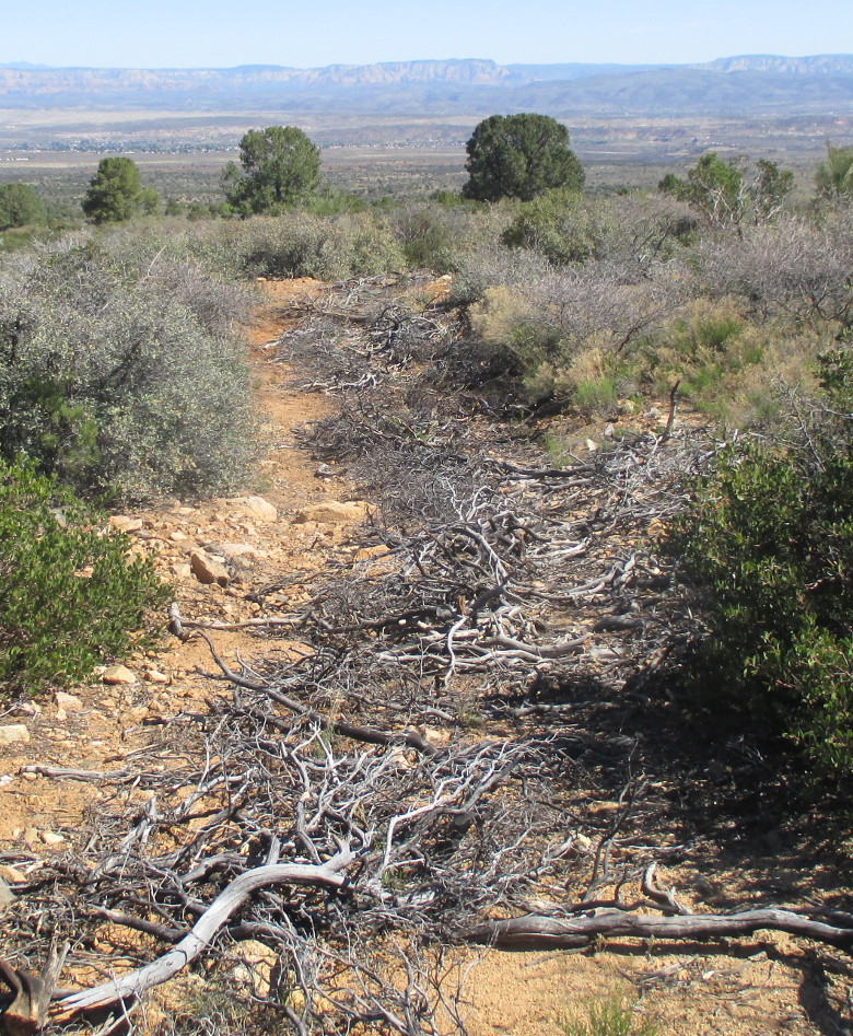
A total of 2.2 miles of FR 9604C, from its start at the intersection with FR9710H to Goddard Tank Two, was closed off. Near the lower end, when vegetation to cut and place in the roadbed had become very sparse, the Forest Service had used an entirely different, but very effective, technique. They had simply used some sort of power shovel to scoop large buckets of soil from one track of the road and deposit them in the adjacent track. They had alternated scooping from one side to the other, so that each track of the road now consists of alternating humps and pits. Each pit in a track is matched by a hump in the adjacent track. This alternating hump and pit pattern can be seen in the photograph (below).

Alternating pits and humps used closing a section of FR 9604C to motorized traffic
Climbing in and out of the pits and over the humps made hiking a bit tedious; on the other hand vegetation had now thinned out so that we could just walk alongside the old road a large part of the time.
When we reached Goddard Tank Two the road closure ended and the remaining 1.8 miles of FR 9604C back to FR 9604D, being used to access the tank, was now in good condition.

Just one mile below Goddard Tank Two, where an overhead powerline crosses the road we found the other (unmarked) end of ATV Trail 514 (or 509). We could have taken that trail from the top and avoided the closed section of FR 9604C. However, it would have been 2.1 miles farther than the way we came.

When we arrived at the end of FR 9604C where it joins FR 9604D (old SR 279) we were just 0.3 miles from our cars and could see them clearly on the far bank of the wash we had looped around on this hike. As a reminder of its past import-ance as a major thorough-fare we noted a small section of pavement (right) still existent on the Old SR 279 roadbed.

We were soon back at our vehicles and ready to head home. I had driven my pickup because I intended to return home by way of Old SR 279. By that route it was only about 3.8 miles to my home in Verde Village 7.

The total hike distance was 8.2 miles, the highest elevation was 4209 feet and the total ascent was 919 feet.

Our GPS track is shown in red on the included map (below).


Sunday, March 13, 2016

Windmill Mountain Hike


Windmill Mountain, rising to 4849 feet at its highest point, is not a very impressive sight from a distance. Cockscomb and Doe Mountain to the northeast are both slightly higher and sport attractive red cliffs as opposed to Windmill Mountain's drab juniper-covered slopes. It does rise slightly higher than nearby Rosies Volcano, 1.7 miles to the east and Windmill Mountain has one very attractive feature that makes a climb to its summit worthwhile: standing apart from other formations in the area, it has spectacular 360 degree views.

We had considered a hike on the mountain for some time and George Everman and I did an initial scouting hike last November, climbing up the southwest slope from Forest Road 525. That, however, turned out to be a very short hike, only 1.3 miles round trip, and all of it was bushwhacking through scattered junipers and thick stands of cactus. From near the top we could see that a series of old roads, apparently used by ranchers to service tanks in the area, led in from the area of the Sedona Wastewater Plant located on SR 89A.

A few days later while returning home from a hike in the Sedona area, we stopped at the entrance to the wastewater treatment plant and hiked about half a mile along an old road just to make sure we could access the mountain from that point. We decided that we could do so and scheduled the hike without further ado.

When we gathered on 12 March 2016 at the Cottonwood Safeway parking lot, the sky was cloudy and a chill wind was blowing. But the weather forecast promised clearing skies starting about noon and we pressed on undeterred. Leaving Cottonwood, we drove north on SR 89A and turned right onto Forest Road 9845A, directly across the highway from the entrance to the wastewater plant. A spacious parking area is located alongside the forest road at the junction with SR 89A, so we parked there and crossed the road to start our hike.

The actual entry to the wastewater facility is set back several yards from the highway and a parking area is provided to the right of the entry gate. We didn't park there because one of our hikers told us that a friend had recently been ticketed for parking in that area.

In the below photograph, the entry gate to the facility is shown at left, the graveled parking area is shown to the right of the driveway, behind the white street address sign, and the dirt road that we would follow to start our hike is shown in the foreground at right.

Start of Windmill Mountain hike at 7500 W SR 89A (Sedona Wastewater Treatment Plant). The dirt road at right is the start of the hike.
I had laid out a track that would allow us to follow an old road up the mountain as far as possible. That turned out to be a distance of 1.3 miles from where we parked. We then followed a track I had drawn along the spine of a ridge, running in the northwest-southeast direction, that ascends at a moderate slope to reach the relatively flat area on top of the mountain at the northeast corner. I had chosen the spine of the ridge because the cactus that grows profusely all over the mountain would likely be less dense there and because it a less steep ascent. As it turned out we were able to follow the track almost exactly, deviating only to avoid thick stands of cactus and a few large rock ledges.

As we approached the point where we would leave the old road and hike up the ridge spine, we paused to look at some familiar nearby landmarks. Lined up from the left (right) are Doe Mountain, the Cockscomb and Rosies Volcano.

We saw a couple of deer moving horizontally along the slope as we approached the mountain and found deer tracks just about everywhere we looked. Near the top of the mountain we flushed a cottontail rabbit from his hiding place in a tangle of brush and cactus.

There was a lot of desert hyacinth in bloom, usually only a single stalk at a time, although I did note one spot where several bunched stalks had pushed up together from behind a rock. Unfortunately, the blooms were not yet well-developed enough for a good photograph. There were also a few banana yucca plants (left) scattered among the cacti.

The wind was blowing steadily during the first part of the hike and, looking for shelter, we chose a spot just below the rim for a snack break. That seemed to work well enough; however, when we climbed on up to the rim after our break, we found that the wind had died down and the sun was struggling to break through the cloud cover.

The essentially flat top of the mountain is a roughly oval-shaped area, orientated almost north-south but with the top bulging to the northeast as though pulled by some unseen force. The area, varying in elevation by no more than about 50 feet, measures about 440 yards long and 120 yards wide at its greatest dimensions. It was covered with grass, isolated patches of scrub oak and scattered junipers. Prickly pear cactus was also present, though growing in smaller, more widely-scattered patches than we had contended with on the climb to the summit.

As expected we had a commanding view in all directions; however, because of the scattered junipers growing on the mountain top, not in all directions from the same point. I thought the most appealing view was to be had looking north-northwest. In this photograph (below) the view extends from Black Mountain at the left to Oak Creek Canyon at the right.

Looking north-northwest from the top of Windmill Mountain
I wondered how the mountain came to be named Windmill. We saw nothing indicating that a windmill had ever existed at the top of the mountain. That does not, of course, mean that one did not once exist there or further down on its slope. Other uses of the name in the area, according to the USGS National Topo Map, are Windmill Ranch which lies about 1.6 miles miles west by southwest of the summit and Windmill Tank about one mile away in the east-southeast direction.

It was too early to eat lunch at the summit, especially as we had just eaten our midmorning snack, so we decided to gather for a group photograph and then head back down the mountain. In the below photograph the hikers are posed with the red rock flanks of Bear Mountain, below a still-cloudy sky, showing in the background.

Left to right: Anita Jackson, Jim Manning, Daisy Williams (front), Joanne Hennings, Roger Fenske, Dolly Yapp (front), Karl Sink, Lila Wright, Collene Maktenieks (front), Jim Gibson (rear), Karalee Schmidt and Mary Beth Hopperstead
I had laid out a return path down the south slope of the mountain that, according to the map I was using, Arizona Topo, downloaded from GPSFileDepot1, would lead us to an old road which would in turn connect us to the route we had followed at the start of the hike. At that point we would be just one mile from where we had parked and could simply retrace the path we had followed before.
As fate would have it, we came immediately to one of the most sturdy, well-constructed barbed wire fences I have ever seen. The wires running between the steel posts had regularly-spaced wooden spacers and boulders were affixed to the bottom wires to hold them tautly in place. We could, with a bit of effort, have crossed the fence and followed the track I had drawn; but the entire south slope was steep and covered with dense patches of cactus. As it really didn't seem to make much difference what route we took, we just followed the fence line down the mountain, deviating often to find a path between clumps of cactus.

We soon realized that we should simply have returned by the route we had used on the way up the mountain. But that would now mean climbing back to the top, so we forged ahead, gathering cactus spines along the way. One particularly nasty spine inserted itself into my boot through the leather upper just above the sole. It was placed so that it only bothered me when I put my foot down at a certain angle, so I just lived with it for the remainder of the hike.

When we arrived at the foot on Windmill Mountain, it appeared that we would need to cross the fence after all to connect to the old road I had identified on the Arizona Topo map. I crossed the fence by lying on my side close to it, lifting the bottom wire, pushing my back, under the wire and then simply rolling over. This is my favorite method for crossing fences. Usually I can accomplish it without even removing my pack. About half of the group followed me across at this spot.

Jim Manning, on the other hand, noting a power line that crossed the fence about 100 yards away, investigated and found a service gate. He, along with the rest of the group, simply walked through the gate. We regrouped on the other side and set a course to intersect my hand- drawn track at the closest point.
This required us to climb to the top of a small knob across which the old road shown on my map ran. On arriving at the top of the knob we found that the old road simply wasn't there and there was no indication that it had ever existed. I was disappointed and quite surprised, as I had even verified the route using another map, Desert Southwest, from the same source. I later noted that Garmin's Topo U.S. 24K Southwest map shows the road running in a different area. But we had already crossed that track and found nothing, although Lila later told me that she had noted what was likely a part of that road running along the ridge east of our course as we neared the spot where we stopped for lunch. I will just call the road I was trying to follow a “ghost road.”

The red track on the included map shows our track to the summit and my advice to anyone hiking to the summit of Windmill Mountain is to return the same way. The blue track running between the summit and the point labeled “End of ghost road” is my intended return route. The copper-colored track, running down the mountain between the blue and red tracks is our actual return route. Finally, the short magenta track running between the labels “Lunch at ghost road” and “Rejoin track” is a part of the ghost road as well as being part of our return route.

The total hike distance was 4.5 miles by the route we actually took. Had we returned by the same route we took on the way to the summit, it would have been 4.8 miles. That extra 0.3 miles is well worth doing to avoid the steep, cactus-infested south slope of the mountain. The highest elevation, as recorded by my GPS, for this hike was was 4643 feet and the total ascent was 899 feet.


1 https://www.gpsfiledepot.com/

Friday, March 11, 2016

From Squaw Peak Road to Salt mine Road


There are a number of interesting trails in the southeast section of the Black Hills Mountain Range south of Copper Canyon (the canyon followed by Interstate Hwy 17 going south from Camp Verde). I have hiked some of these trails beginning in early 2008 when I first started carrying a GPS to record my hikes with the Skyliners. I have written reports and recorded GPS tracks for the following hikes:

Chasm Creek #164
Tompkins Trail #513 (partial)
Ryal Canyon Trail #521
Goat Springs Trail #542
Lower Cedar Bench Trail #540
Oxbow Trail #163
Pine Mountain Verde Rim Loop (multiple trails)

We, Lila Wright and I, looked at the trails in the area while we were preparing the Skyliner's April 2016 schedule. We had two empty slots to fill on our schedule of weekly hikes. I did some online research, primarily using HikeArizon.com1, as the Prescott National Trail descriptions are more noticeable for their lack of information than anything else. Usually they just provide the starting point, the ending point and the length of the trail. HikeArizon.com (HAZ), on the other hand, usually provides trail descriptions along with downloadable GPS tracks.

It appeared that we could complete our April schedule quite nicely by splitting Trail 511 at Box T Spring and hiking it in two separate sections. An alternative would be to hike on one section of Trail 511 (Box T Trail) on one weekend hike then complete the part of Trail 513 (Tompkins Trail) that we had not already hiked on the second open date. Because these trails were new to us we would need to scout them before actually leading hikes on them.

Our first thought was to do the two hikes on Trail 511 and we decided to scout what appeared to be the most difficult section of Trail 511 first. That was the section between Box T Spring and Salt Mine Road. From the available data, that appeared to involve hiking 2 miles on a forest road to reach Box T Spring and then hiking 7.1 miles on Trail 511 to its end on Salt Mine Road. The rest of this report describes our 2 March 2016 scouting hike on that selected portion of Trail 511

Leaving Cottonwood at 0700, Lila, Karl Sink and the author drove on SR 260 through Camp Verde, continued past I-17 for 0.7 miles, turned right on Oasis Drive and followed it for 0.4 miles, turned right onto Salt Mine Road and continued for 2.2 miles before again turning right and passing through a gate to park one of our two vehicles at position N34 31 30.6 W111 51 53.2. The wire gate was open and the end support piece to which the gate wires were attached was broken; we could not close it behind us as instructed by a posted sign, so left it as was. We then drove in the second vehicle back to I-17, entering at the General Crook Trail Intersection, and drove south to the SR 169 Exit. There, instead of turning west toward Dewey-Humboldt, we turned east onto Forest Road 732 and drove 2.9 miles to park at the junction with FR 9602G.

Forest Road 732 (also shown on some maps as FR 68D or even as SR 169), although dirt, was in first class condition for the first 2.5 miles. At that point it crossed a cattleguard and turned down a short, steep hill, becoming a lot rougher as it descended. It was still usable by a regular passenger vehicle; it would just require a bit of care. As we made our descent down the hill, we could see a thriving community, shown in the photograph (below), and a section of our road (denoted in the photograph by a red arrow) as it climbed the far side of a wash that empties into Cienega Creek. The dwellings and other buildings were nestled closely alongside Cienega Creek. I saw power lines between the various buildings in the community but no line leading into the area and at first assumed they operated a privately-owned generator. However, I did locate the supply line on a later hike.

Community of Flowerpot? - at least some of the buildings in the right half of the photograph are located on Bald Hill Ranch

The name of the community is unclear. Garmin's Topo U.S. 24K Southwest map displays the name “Flowerpot” at a point just 0.4 miles to the northwest and shows a Flowerpot Tank about 2 miles directly west. On the other hand, the location where the tank is situated is labeled Flowerpot Ranch on the National Topographic map.

Adding even more confusion, going straight ahead at the bottom of the hill, where the forest road turns left on entering the community, would take one through a gate (right) into Bald Hill Ranch. This appears to be the ranch headquarters. Bald Hill Peak, presumable the source of the name, lies over three miles south by east from this point.

After the short, rough section passing through the community, the road becomes fairly smooth again and follows along a short, pleasant stretch of Cienega Creek that actually has flowing water, apparently year round. The water emerges from the streambed at a clump of sycamore trees, flows strongly for a short distance and then is reabsorbed into the thirsty creekbed. Just as the traveler enters this oasis-like area, Forest Road 9602G originates, heading sharply up the steep bank on the left to make its way to Box T Spring.

Beginning of FR 9602G to Box T Spring. The road seen at left, running past the cattleguard, is FR 732 heading back to I-17; FR 9602G runs directly up the hill. Note that the sign indicates the distance back to I-17 is 4 miles. It is really only 2.9 miles.
We parked our vehicle here and started our hike up FR 9602G to join Trail 511 at Box T Spring. A 4-wheel drive vehicle could easily handle this road, although there are some areas of close-growing brush that might add a few scratches to one's paint job. There was some climbing along the way as the road descended into and climbed out of washes and we encountered a few stretches of loose rock, making walking difficult. The distance to the spring turned out to be 2.0 miles as advertised. The road actually intersects Trail 511 about a 100 yards west of the spring and we didn't even see it on the way through. We did investigate the spring more closely a week later while scouting the rest of Trail 511. On first approach, no spring was visible, just a large rectangular metal tank setting in an open grassy area. However, a closer look disclosed that the tank actually formed part of the spring. There are no above-ground pipes feeding water to the tank; it has apparently been fitted over the mouth of the spring so that the water flows into the bottom of the tank and fills it up before overflowing from the top as shown in the below photograph. I suppose it is possible the spring might be located farther up the mountain and the water piped underground to the tank. But we saw no signs of that.

Box T Spring – the tank is fitted over the opening of the spring

There were no cattle in the area when we passed through on this 2 March scouting hike and we saw no wildlife other than a few birds.

However, when we again visited the area a week later, we did see a jackrabbit. He seemed entirely undisturbed by our presence and loped on down the trail in a leisurely fashion, giving me time to take my first ever jackrabbit photograph (left).

We left the spring following Trail 511 up the mountain to Box T Tank. The trek up the mountain was along a steep, well-defined trail that was littered with loose rock much of the way. We found a few flowers along the way and I stopped to photograph a particularly striking patch of Indian paintbrush (right) hiding under some brush.

We climbed over 800 feet in 1.7 miles to reach the tank. With still another hundred feet to go before we reached the summit, we paused to look at the tank before continuing our climb. The tank, shown below, is actually located about over 100 yards from the trail.

Box T Tank

Look closely at the photograph above and you can see a fence that crosses the tank in line with the dead tree, neatly dividing it approximately in half and permitting watering from two different pastures.

Leaving the tank behind we climbed the remaining 100 feet in the next 0.2 miles and were at the summit of the Black Hills Range. The elevation was 5867 feet, we had climbed over 1200 feet and hiked 4.1 miles. From here we would descend 2574 feet to the end our hike at an elevation of 3293 feet.

After a short rest stop we started our descent, at first descending quite rapidly along a trail that was littered with loose rocks (below left), eventually leveling off to a more moderate descent with fewer rocks (below right).

After the first 0.4 miles of steep rocky trail, we found ourselves descending at a somewhat more leisurely pace along the upper slope of Allen Canyon. None of us had seen the Verde Valley from this perspective before and we paused occasionally to try and pick out points of interest that were familiar to us. About 1.2 miles from the summit at an elevation of 5362 feet, we passed along the brow of a high ridge that separates Allen Canyon from Ryal Canyon. It was now time for lunch and this looked like an ideal spot, so we detoured a few yards to a good viewing area and stopped to eat.

After lunch I managed to get in a quick nap and take photographs to stitch into a panoramic view across Verde Valley to the Mogollon Rim. In the scene below, looking northeast down Allen Canyon, the San Francisco Peaks can be seen at left and Wingfield Mesa at right.

Looking across the Verde Valley from a ridge between Allen Canyon and Ryal Canyon. The elevation is 5362 feet
As we continued our trail turned at first northwest and then north and finally east as we descended into Ryal Canyon at the spring. Some maps refer to it as just Spring, others call it Ryal Water. I supposed it would be accurate enough if one were to just call it Ryal Spring and be done with it. The descent into the canyon, like the initial descent from the summit, was quite steep and the trail surface was composed of gravel or small rocks. I slipped twice and sat down heavily. Luckily I am practiced in the art of sitting down suddenly and as always
managed to do it with grace and little damage. Lila and Karl are shown here (left) picking their footing carefully as they descend Trail 511 just above the junction with Ryal Canyon Trail #521.

From their Junction, Trails 511 and 521 run together for a few yards down toward the stream below Ryal Spring. There Trail 521 ends while Trail 511 continues along the bank of the stream for a few yards and crosses the stream at a tidy, well-constructed little bridge.

Bridge over the stream below Ryal Spring

I had hiked to Ryal Spring with the Skyliners before. However, we had just accessed the stream where Trail 521 ended and never even saw the bridge. Now, following Trail 511, we crossed the bridge, climbed out of Ryal Canyon, crossed over the dividing ridge and followed along the Allen Canyon side of the ridge down the mountain. Along the way we passed an old mine site that I could not identify in the literature. A gorgeous stand of California poppies was growing on the bank below the mine works and they continued along the trail for a considerable distance, culminating in the dense stand seen here (above right).

The trail now descended steeply from the mine site (left) and was covered with loose gravel, again making travel pretty precarious. Ceanothus (white lilac) shrubs lined both sides of the road and were in full bloom, enveloping the area with a distinctive lilac-like scent.

An excellent example of the ceanothus is shown here (below left) along with a hardy desert hyacinth (below right), the hyacinth thrusting its way out of a safe spot between two rocks while the ceanothus stands boldly alone.

Still about 2.2 miles from the end of our hike and a little over half a mile above Cottonwood Spring, the trail turned to follow in an easterly direction along the spine of a gently-sloping ridge. It then turned north to descend the flank of the ridge, crossed the wash and climbed out the other side heading northwest. It then turned north by east in a straight line to where we were parked just 0.4 miles ahead.

I have described the twists and turns of the lower portion of the trail in some detail because there are several places where one can go wrong in this area. The trail follows along old roads, signage is nonexistent and there are several side roads that would appear to be a more direct route. It is best to refer to a good map or, as in our case, a GPS track to avoid wrong turns.

When we arrived back at our vehicle, we found that the gate had been repaired, using a short length of iron pipe and duct tape to bind the two pieces of the broken post together. It worked well and looked quite sturdy.

We decided that this section of Box T Trail #511 was not a good candidate for a Skyliner hike and that I should go ahead and write a report describing our this scouting hike for inclusion in the Skyliner library of reports. That meant, of course, that we would need to scout both of the other alternatives discussed at the beginning of this report, the section of Trail 511 from Joe Best Spring to Box T Spring and the section of Trail 513 from Box T Spring to the end of a 12 February 2008 hike on Trail 513 hike that ended above Tompkins Tank. For scouting purposes we combined those two alternatives into a single hike which Lila and I did on 9 March 2016. That hike is the source of the description of Box T Spring included above.

Our GPS track is shown in red on the included map (below). The track includes the short side trips (to inspect Box T Tank and to a view point at lunch) we made along the way. The total hike distance was 9.9 miles, the highest elevation was 5867 feet, the total ascent was 1675 feet and the total descent was 3047 feet.


1 https://www.bing.com/search?q=hikearizona.com&qs=LC&pq=hike&sc=8-4&sp=1&cvid=2C5EB71C71A3474ABB18206F0595E19E&FORM=CHRDEF

Monday, March 7, 2016

Aerie-Cockscomb Loop


The Aerie-Cockscomb Loop is well-used by both bikers and hikers and we had been advised a couple of days before our scheduled hike that the Sedona Mountain Bike Festival would be underway on 4-6 March 2016. Our hike was scheduled for the 5th, right in the middle of the festival. We gave some thought to rescheduling. However, it was too late to change the notice in the newspaper, so we chose to forge ahead. The trails were, after all, intended for multiple use.

From Cottonwood we drove to Sedona, turned left onto Dry Creek Road, drove 2.9 miles to the stop sign at the junction with Boynton Pass and Long Canyon roads (Boynton Pass Road to the left; Long Canyon Road to the right), turned left onto Boynton Pass Road, continued for 1.6 miles to a stop sign, turned right onto Boynton Canyon Road and continued for about 0.1 mile before turning into the Boynton Canyon Trailhead parking lot on the right.

We arrived at the parking area around 0830, early enough to be sure we would have no trouble finding parking space. Generally speaking, the trailheads around Sedona start filling rapidly after about 0900. The Aerie Trailhead (right) where we started our loop hike is located at the toilet facility, just across the driveway from the more prominent Boynton Canyon Trailhead.

We had expected to share the trail with a large number of bikers and were a bit surprised to find that we had the trail to ourselves for the first 1.4 miles when the first biker passed us. After that lone rider, biker traffic slowly picked up, increasing steadily for the remainder of the hike. We were a rather large group, 13 in number, and were pretty well spaced out. Knowing that passing us all would otherwise be a very tedious affair for bikers, we passed the word down the line each time we met one and all stepped off the trail until the biker or bikers had passed. The words “biker ahead” brought back an old memory from my time on the USS Hornet. While practicing for the 24 July 1969 Apollo 11 splashdown, we steamed around in circles in the Pacific Ocean searching for pieces of plywood previously tossed overboard and shouting out “chips ahoy” each time we spotted one.1

But back to the present. After leaving the trailhead, we had paused briefly for a group photograph (below) using the yawning mouth of Boynton Canyon for the background.

Left to right: Loren Pritzel, Karl Sink, Jim McGinnis, Ellen McGinnis, Lila Wright, Collene Maktenieks, Joanne Hennings, Jim Gibson, Beverly Sass, Daisy Williams, Akemi Tomioka and George Everman
We crossed Boynton Pass Road and then a dirt road before coming to our first trail intersection. There are a lot of crisscrossing trails in the area and these, at least in our case, required frequent use of a map or GPS track to make sure we took the correct path. The weatherproof plastic map signs (below) posted along the way were very helpful.

Donated maps posted at many trail intersections in the area
The trail junctions were uniformly and reliably signed as shown in this photograph (left). The signs varied a bit in size, depending on the lettering required, and in age but they were all similar in style and all were firmly planted so as to remain pointing in the correct direction.

Doe Mountain, which we circled in a counterclockwise during this hike, is shaped roughly like a triangle with points to the northeast, southeast and southwest. Our path, following Aerie Trail led us, on a dogleg course, partway up its northeast slope to an elevation of about 4730 feet. From there we had an excellent panoramic view of Red Rock Country to the northeast. Unfortunately, the sun was in our eyes and did not provide good lighting for photography. However, we soon rounded the northeast corner of Doe Mountain and had an excellent view to the northwest from Mingus Mountain, hidden behind the tree at left, across Woodchute Mountain on the horizon, to the forbidding shape of Bear Mountain to the right.

Looking northwest from the east slope of Doe Mountain
A little farther along the slope of Doe Mountain as we turned toward the pass between the mountain and the Cockscomb Formation, we could see across Verde Valley to Black Mountain and Casner Mountain and between them the mountains beyond Sycamore Canyon.

Looking across Verde Valley from Aerie Trail – Black Mountain is at the left, Casner Mountain is right of center with the faint red splotch of Robbers Roost along its slope and Loy Butte is seen at right across the shoulder of Bear Mountain.
It was interesting as we walked along to consider how the maze of trails we observed had come into existence. It appears that the older sections of trail follow the course of old roads that were intended to move people and goods from place to place. These, although generally following land contours, did give some consideration to the shortest distance from point to point. Newer trails, on the other hand, appear to have been designed more for the trail experience than to connect any specific points, winding often through washes and around hills that could have been avoided.

As previously noted, biker traffic increased throughout the hike and we encountered an estimated total of somewhere between 125 and 150 along the way. This, however, turned out to be no problem as most of the riders were in groups of four to six and passed quickly, with a courteous greeting, when we stepped off the trail. Sharing the trail with the bikers today was even less trouble than during an October 2014 hike to Cathedral Rock. The numerous bikers on that hike were also quite courteous but had seemed to be traveling singly rather than in groups and so had to be contended with individually.

As for other hikers, I remember only a man with a dog, a single woman hiker who passed us along the way and two women who apparently hiked only a short way on the trail before turning back.

After we rounded the south side of Doe Mountain and headed north along its eastern slope, we once again had panoramic views of the Red Rock Country to the northeast. This time the lighting was much more favorable and I snapped several photographs for a panoramic view.

Looking into Dry Creek Canyon and the mountains beyond. Capitol Butte is shown at right and Chimney Rock is barely visible between the butte and the tree at the right edge
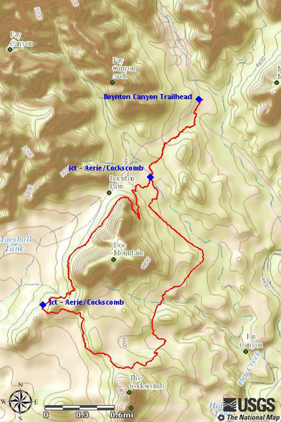
Our GPS track for this hike is shown in red on the following map. The total hike distance was 7.2 miles, the maximum elevation was 4728 feet and the total ascent was 777 feet.


1 Price, Ellis F, At Sea & Ashore During Vietnam. Createspace, 2011, Print, Page 73